
Yesterday’s Weather
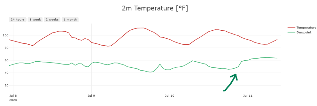
Except for eastern New Mexico, the rest of the region was suppressed due to high pressure and dry westerly winds that lowered surface dew point temperatures during the day, though more surface moisture moved in during the night. Tucson dewpoint temperature dropped to 42°F yesterday afternoon, but increasing to 65°F by 3am this morning.
A Mesoscale Convective System (MCS) developed just south of the border yesterday and moved southwest to the Gulf of California. It was responsible for the push of moisture into Arizona overnight.
Analysis
A tropical upper-tropospheric trough (TUTT) is in central Mexico near Aguascalientes moving slowly west. Another TUTT has moved into the southeast Gulf of Mexico, but the center seems to be elongating as it moves westward.
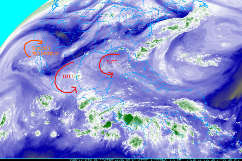
At 250mb, the monsoon ridge of high pressure has moved into Pacific Ocean southwest of San Diego and the ridge axis extends eastward to a col in southern Louisiana and then across north central Florida. The high has been pushed south in the eastern U.S. due to several troughs, one moving off the east coast and another dropping east out of the Rocky Mountains (shown by the darker blue to yellow colors reflecting drier air in the water vapor imagery).

The high pressure ridge at 500mb is centered over the south of San Diego with the ridge axis extending east to central Texas. Winds are from the west at 20 kts across the northern part of the region becoming light and variable with the ridge axis by the international border. Warm air is advecting eastward across the region north of the ridge axis.

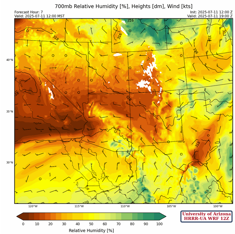
At 700mb, dry air is advecting into the state from California and will spread actross the region the next few days and spread into northern Mexico. This will scrape out a lot of moisture from the region.
Today
New Mexico is expected to see thunderstorms in the east, with a potential for strong microbursts with gusts of up to 50mph in southeast New Mexico along the Texas border. Strong storms in the northeast may also have microbursts associated with them.
Despite high dewpoints and another push of convective available potential energy (CAPE) into the state, storms are not expected in Arizona. Strong convective inhibition (CIN) will prevent anything from firing off, as it did yesterday, and we won’t reach the near surface temperatures needed for spontaneous convection (106°F for Tucson, 112°F for Phoenix).

Tomorrow
More widespread thunderstorms are expected in New Mexico tomorrow, with storms over the mountains throughout the state. Strong microbursts with gusts of up to 50mph are possible in central New Mexico. Some isolated storms are possible over the White Mountains and Cochise County in Arizona tomorrow.
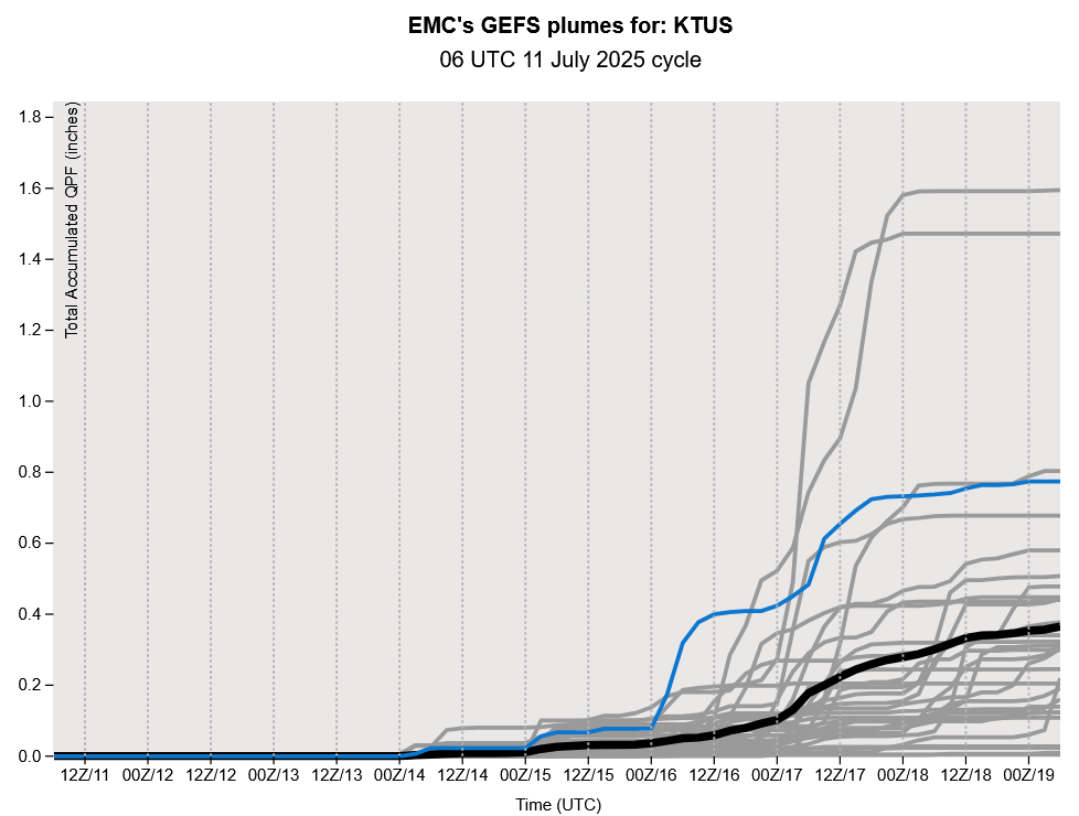
Total accumulated precipitation for the next two days is pretty bleak, other than southeast New Mexico given the chance of thunderstorms there tomorrow.

Outlook
Storms come back into the forecast for Arizona on Sunday as 500mb flow shifts to the northeast, with widespread light rainfall expected over the southeast. Strong microbursts winds will hit the southern third of New Mexico, west of El Paso westward to southeast Arizona, withs gusts up to 50mph. Without much rain yet this monsoon, there is a threat of dust storms in the same areas, as the soil mositure is still dry.
Discussion written by Pat Holbrook