
Yesterday’s Weather
Yesterday’s weather was pretty close to what was predicted. Low level moisture in Arizona that moved in the morning met dry air resulting in drying out of the lower levels. Tucson maximum dewpoint temperature was 61F in the morning and ended up in the middle 40s in the afternoon. The satellite picture below shows the low-level water vapor the region with the monsoon flow in New Mexico.
Convection along the spine of the Sierra Madre mountains in Mexico showed less intensity. The best storms were in the Ruidoso/Mescalero Reservation area in south centeral New Mexico, but they dissipated after they came off the mountains.
Analysis
At 250mb, the trough has moved a little further south today, with stronger westerly flow in our region. There is also an upper-level low along the tropical upper tropospheric trough (TUTT) in the Gulf of Mexico moving westward.
At 500mb, temperatures have cooled off and the winds remain strong and westerly.

At 700mb, the moisture axis has shifted only slightly further to the east in New Mexico. Arizona also has cooled down further and has slightly higher dewpoints, but not high enough to do anything.
In the sounding from Empalme near Guaymas, Mexico is shown below. Notice the low-level moisture below 900mb. Visible and low-level water vapor satellite pictures show this moisture moving northwards and should make its way into southern Arizona tomorrow morning. This may also bring some convection into northern Mexico later today.

Today
Today will be similar to yesterday, except the winds will be weaker. More widespread thunderstorms are expected in the eastern half of New Mexico. Thunderstorms around southeast New Mexico may contain strong winds, with peak wind speeds around 40mph.
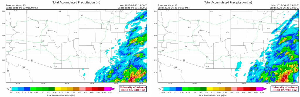
Total accumulated precipitation through to sunrise tomorrow shows areas in southeastern New Mexico and west Texas with more than 1.5 inches.
Temperatures will be slightly cooler in New Mexico and Arizona. A red flag warning remains in effect for northeastern Arizona. There is also a wind advisory currently in effect for southeastern New Mexico.
Tomorrow
The moisture moving northward from Guaymas should make its way into Arizona by 12 noon local time. This should punch up the Colorado river but mix out during the day. This moisture should bring some thunderstorms into the mountains of southeastern Arizona and scattered across the mountains throughout the entirety of New Mexico.
Warmer temperatures begin to creep back into Arizona, but New Mexico will remain around the same temperatures. Winds will also be very similar to the day before. The sounding for San Simon at 3pm local time below shows strong CAPE and weak CIN. This inverted-v sounding indicates strong microburst potential, with 800 [J/kg] DCAPE.


Outlook
The axis of the monsoon moisture is shifting further west, bringing additional thunderstorms to eastern Arizona. New Mexico will continue to receive lots of precipitation over the next few days. The upper-level low along the TUTT in the Gulf of Mexico will continue to travel westward, eventually weakening in Mexico. This may aid convection in central Mexico and push moisture northward and aid in the monsoon circulation. While storms begin to form in southeast Arizona, New Mexico will accumulate quite a bit of rainfall over these next three days looking at the accumulated precipitation totals through to midnight on Tuesday evening.

Discussion written by Pat Holbrook