
Yesterday’s Weather
Yesterday’s HRRR-UA WRF 12Z forecast was excellent with the formation and movement of the thunderstorms in southwest Arizona and the Kingman area. The storms that formed west of Tucson to Ajo and southern Maricopa County were constrained in their movement. The atmosphere north of the storms did not have Convective Available Potential Energy (CAPE) due to low-level dry air moving into the state on strong southeast winds. Outflow from the storms did increase surface dewpoint temperatures into the 60°F range overnight in parts of the lower deserts.
The 24-hour accumulated precipitation forecast from yesterday’s HRRR-UA WRF 12Z (below, left) is compared to the equivalent observations from MRMS (below, right). The location of precipitation in both states was excellent. On the accumulated precipitation map, the lower precipitation totals in the V-shaped cone is from radar beam blockage at the Tucson site. In this area only the tops of the storms can be seen by the radar beam. The model underestimated the precipitation amounts in central and western Pima County, where training of storms occurred (one “train car” or thunderstorm cell after another).

Analysis
Surface dewpoint temperatures have dropped in southern and southwest New Mexico due to the east wind flow. Dewpoints have increased in portions of Pinal and Maricopa counties due to the thunderstorm activity yesterday.

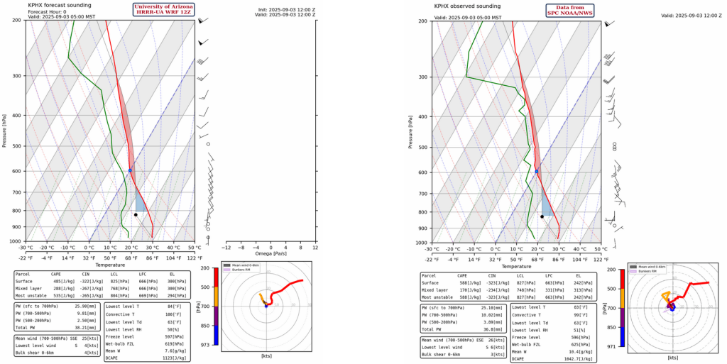
The observed sounding at Phoenix from 5am and the HRRR-UA WRF 12Z model initialization are very similar today. The tropopause is at 48,000 feet (250mb), so thunderstorms would be able to grow to that level with the strongest updrafts (this will be more impactful for Thursday more than today, as there’s an inversion near Tucson and not enough Convective Available Potential Energy (CAPE) in Phoenix, read more on this later).
The GOES-19 visible satellite picture from this morning shows mid-level clouds over the northern half of the state, while mid- to-high-level clouds are over the southeast. The high clouds in southeast Arizona come from a Mesoscale Convective System (MCS) over northwest Mexico yesterday that has now dissipated.

Hurricane Lorena is still moving northwest parallel to the Baja Peninsula. The radar reflectivity of the hurricane from Cabo San Lucas, Mexico, is below and shows a well-defined eye with tight spiral bands around the center.
The National Hurricane Center forecast track for Hurricane Lorena is below.
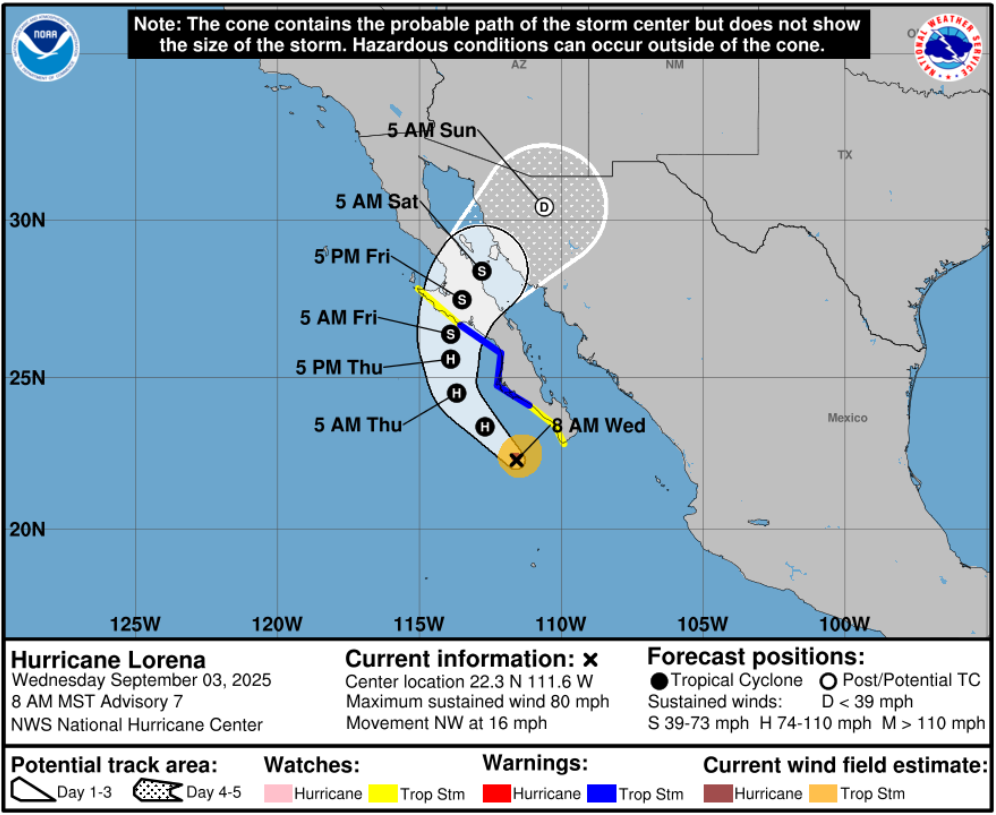
There is still a large difference between the different global modeling systems; the GFS model forecast (below, left) keeps the storm circulation intact as it encounters increasingly strong westerly winds aloft. The ECMWF forecast (below, right) strips the thunderstorms from the hurricane near the tip of the spur of the Baja and what remains of the low-level circulation moves west into the Pacific. Both scenarios will bring rain, but the GFS forecast will bring much heavier rain to southern Arizona, while the ECMWF would spread scattered storms into the state. Since the HRRR model is initialized using GFS data any inaccuracy with the GFS will also impact the HRRR. So, until the track and strength of the storm becomes clearer the amount of rainfall forecast from Arizona has significant uncertainty.

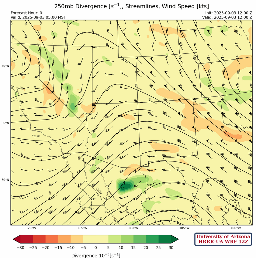
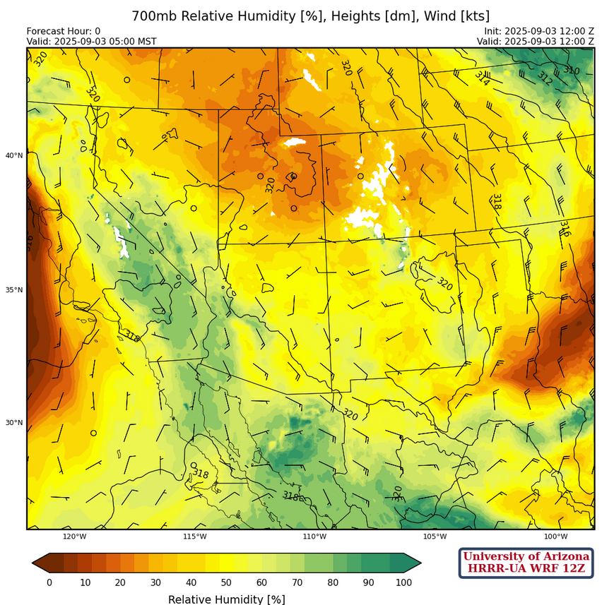
At 250mb, the high-pressure ridge is in central Mexico with a trough in eastern California. Southern Arizona will be in weak upper-level divergence by this afternoon.
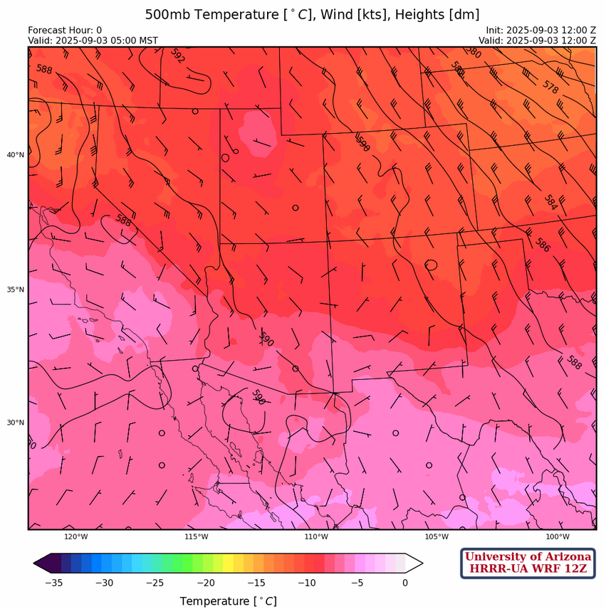
The wind speed in Arizona at 500mb has weakened significantly from the 20 knot east winds yesterday to southeast at 5 to 10 knots. This will slow storm motion and raise the potential for heavy rain/flash flooding with stronger storms in central and western Pima County today.
At 700mb, moisture extends from north/central California southeast to northwest Mexico. The winds in southeast Arizona are expected to weaken during the day and the drying seen yesterday from Tucson to Phoenix will lessen today.
Today
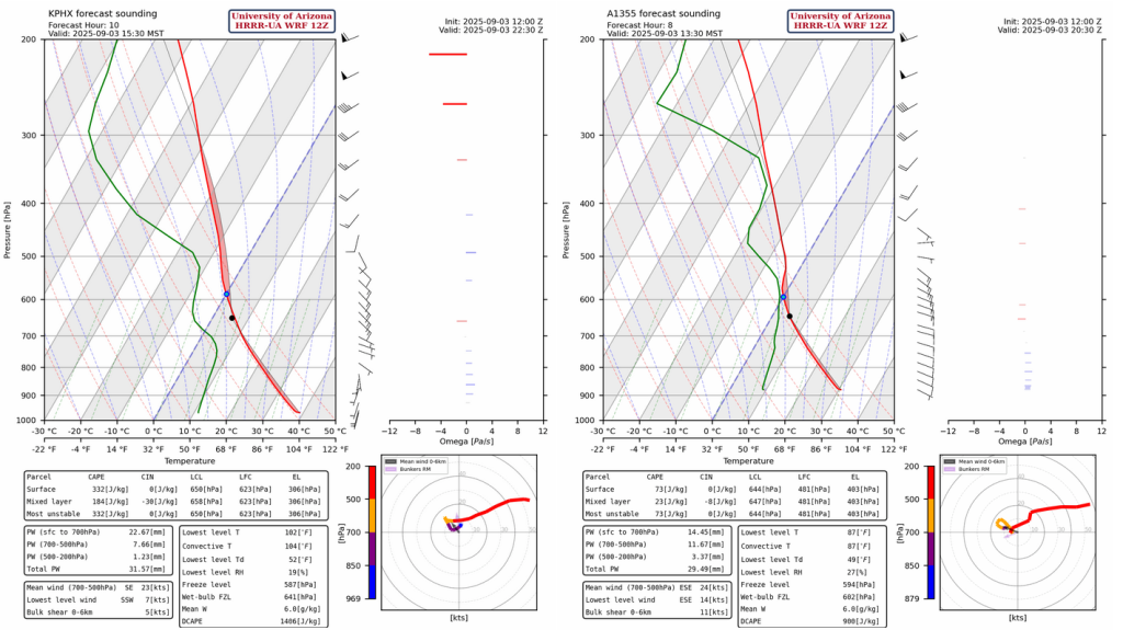
The forecast sounding for Phoenix at 3:30pm (below, left) is the time of the daily minimum Convective Inhibition (CIN), and mixed-layer CAPE is forecast to be ~180 [J/kg] during this time. Wind flow is from the southeast, so any storms that form should be in the mountains north and east of Phoenix. The forecast sounding for Nogales at 1:30pm (below, right) seems to have a mid-level cap (inversion) near 520mb which prevents thunderstorms forming. The forecast sounding for Tucson is more similar to the one for Nogales.
The HRRR-UA WRF 12Z radar reflectivity forecast shows storms form in the mountains near Tucson and Nogales and move westward to Ajo and eastern Yuma County by evening. Other storms will form across the northern part of the state and move northwest and weaken by midnight. No strong winds are predicted in the region today.
Tomorrow
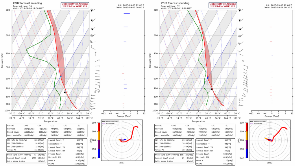
The forecast soundings for Phoenix at 5pm (left) and Tucson at 1:30pm (right) are show below. Regardless of which model (GFS or ECMWF) is correct about the exact track of Hurricane Lenora, Arizona should be in a favorable upper air environment for thunderstorms tomorrow afternoon as there is divergence at 250mb. Both the GFS and ECMWF model have the circulation from Lorena approaching Arizona by Thursday evening, though just remenants of circulation in the ECMWF, meaning there will be positive vorticity advection which is favorable for thunderstorm development. Wind gusts will be about 45mph and will help push the storms up to Phoenix by evening.
The radar reflectivity forecasts a significant precipitation event for Tucson tomorrow from thunderstorms before the arrival Lorena. The forecast accumulated totals for Phoenix could be greater, increasing the potential for flash floods anywhere from Tucson north to Casa Grande and Phoenix.
Outlook
The precipitation from the outer bands of Lorena is forecast to move into southern Arizona during the evening hours of Thursday and advance north. Rainfall from Lorena will then move into southern Arizona and New Mexico Thursday night into Friday. Rain will exit Arizona during the day Saturday and remain over New Mexico into Sunday.
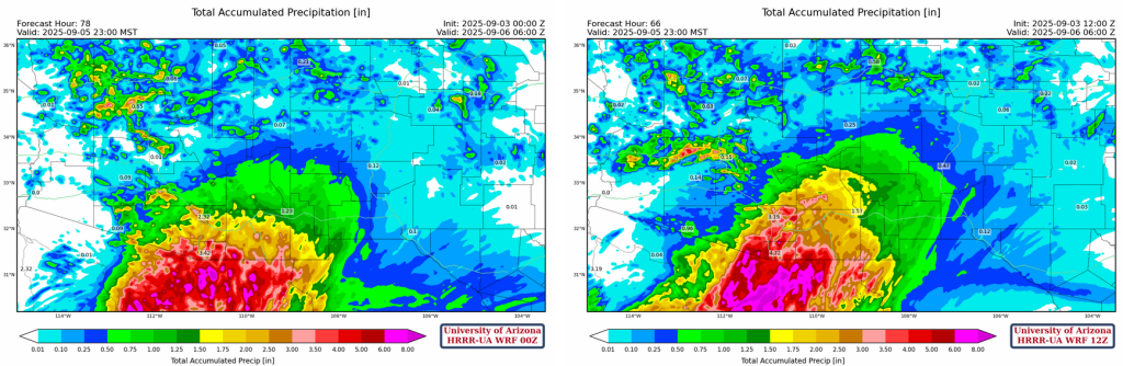
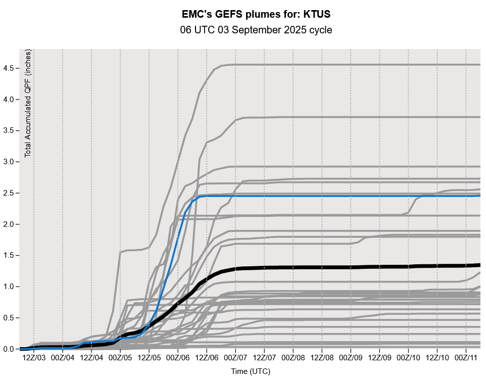
The HRRR-UA WRF forecasts below have significant precipitation totals over the next 72 hours (>3″), though these forecasts are mainly reflecting the GFS forecast of Lorena’s track. The accumulated precipitation forecast for Tucson is ranges from 1.25 inches from EMCWF forecasts, to over 3 inches with the GFS. Since 1894 there have been six precipitation events this time of year in Tucson that caused over 2.5 inches.
The GEFS plume forecasts below show the wide range of rainfall predicted for Tucson. The ensemble mean is 1.32 inches which is very close to the ECMWF forecast.
Discussion written by Pat Holbrook and Patrick Bunn