
Yesterday’s Weather
Yesterday, thunderstorms developed in northern Pima County at 5pm and moved slowly northwest along I-10. The storms were able to flourish in a low Convective Available Potential Energy (CAPE) acting like Pacman eating the available CAPE as they moved northwest. Outflows are visible in the radar reflectivity below, and their collisions helped in getting the first vertical push up into the low CAPE environment. Storms arrived in the Phoenix metro area around 10pm and continued westward to Wickenburg and Wenden finally dissipating around 4am.
Yesterday’s HRRR-UA WRF 12Z 24-hour accumulated precipitation forecast (below, left) is compared to the equivalent observations from MRMS (below, right). The 12Z forecast missed the storms from Tucson to Phoenix, as did later runs (15Z, 18Z, 21Z). It took until the 00Z forecast for the precipitation to be represented in the forecast, but even that didn’t have as much precipitation as what actually fell in Phoenix.

Here are the Rainlog gauge observations for Phoenix (top) and Tucson (bottom) metro areas.

Even the cloud camera picked up the storm in the north/north west part of Tucson.
Analysis
We’re back to the tale of two states however this time Arizona has the moisture and New Mexico is dry. Fortunately, the flow is from the south and any dry air in New Mexico will not affect Arizona over the next few days.

The observed sounding from Phoenix at 5am (below, right) shows over 1.5 inches (39mm) of precipitable water with winds of 10 knots or less below 500mb. The HRRR-UA WRF 12Z initialization sounding (below, left) is very similar to the structure of the observed sounding. Like yesterday the convective temperature of 98°F may not be achievable, but with so much moisture above 700mb outflows could give the near surface push for thunderstorms to initiate. Pacman may be active again.

The latest forecast from the National Hurricane Center (NHC) shows Tropical Storm Lorena weakening and dissipating off the west coast of the Baja Peninsula. It’s a stark difference from yesterday’s cone. The text below is from the NHC discussion:
“The GFS model and all of NHC’s consensus guidance (including the HCCA, Google DeepMind, and TCVE) have come onboard to the solution that the ECMWF, UKMET, and CMC models have been advertising for the past couple of days, which shows Lorena slowing down and dissipating offshore, to the west of Baja California.”
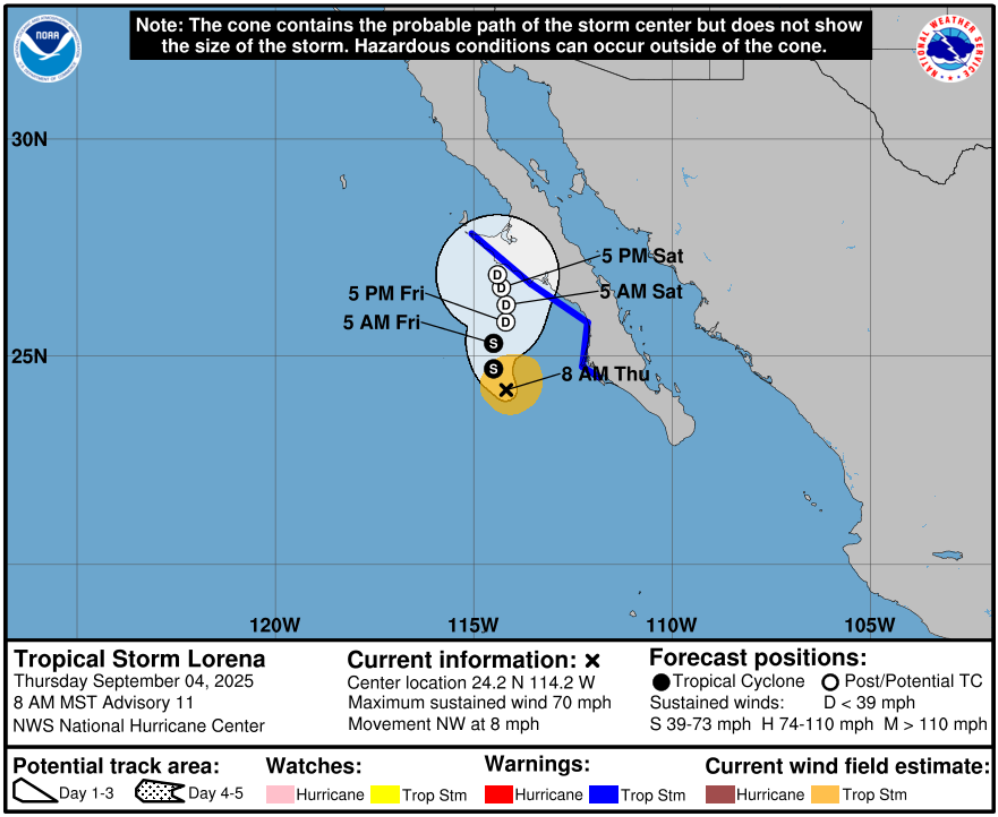
Yesterday, there were two distinct scenarios being forecast by the ECMWF and GFS global modeling systems. Today both models, except for minor variations, are in-sync and favoring the ECMWF prediction from yesterday. Both modeling systems likely ingest similar observations, though there’s not good coverage in this area of the globe and the ECMWF uses a sophisticated 4DVAR data assimilation method to incorporated the observations into the forecast initialization. Also, the ECMWF model is run at a smaller grid-spacing (about 14km vs GFS’s 27km), and it uses a more traditional spectral dynamic core. The GFS uses the more recently developed, computationally efficient, FV3 finite volume dynamic core.
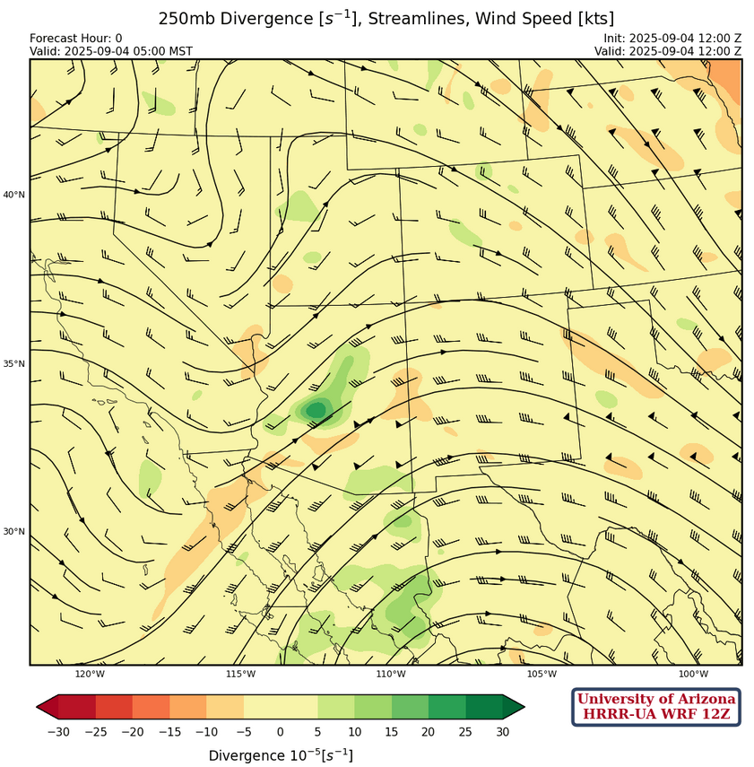
At 250mb, a trough is moving into Arizona today providing some divergence aloft over southeast of the state as it moves east.
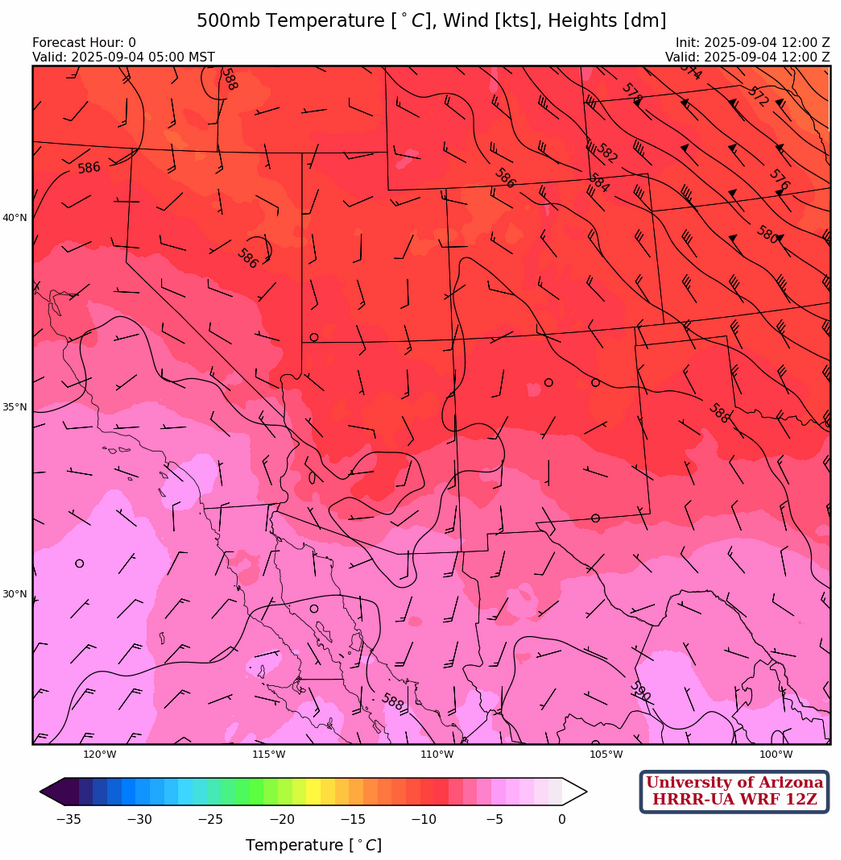
It is still cold aloft at 500mb with temperatures of –8°C at Phoenix. Such cold temperatures will support storm development this afternoon.
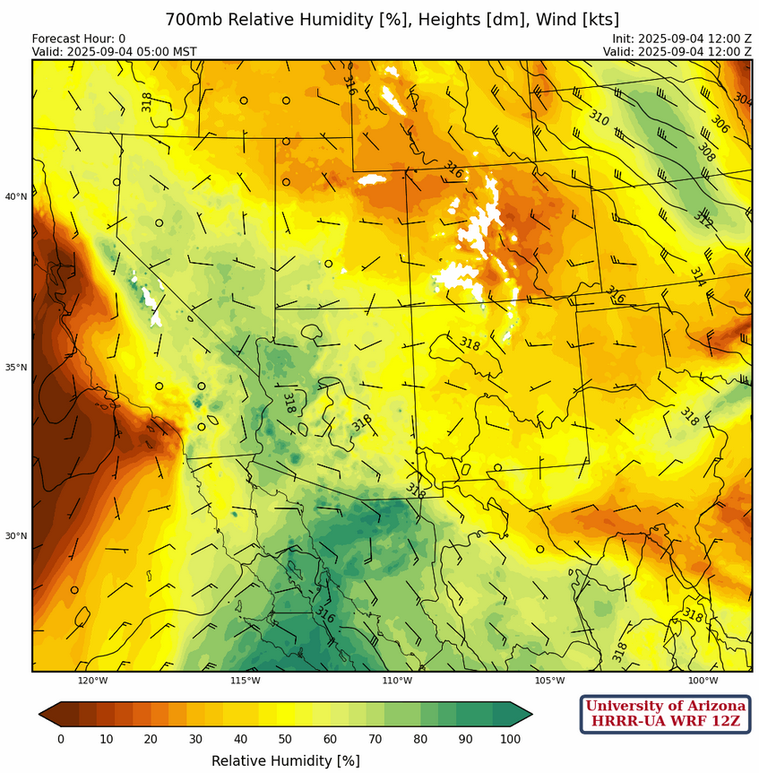
At 700mb, dewpoint temperatures are above 6°C west of a line from Tucson to Flagstaff then further west into central California. Even higher dewpoint temperatures are in northwest Mexico extending down the Gulf of California.
Today
The forecast soundings for Phoenix at 5pm (below, left) and Tucson at 1:30pm (below, right) look very similar to each other today. Both have a little Convecitve Inhibition (CIN) to overcome, but higher CAPE values that what was available for yesterday’s storms. The boundary layer winds are weak, so movement of storms will be very slow and mostly due to propagation.
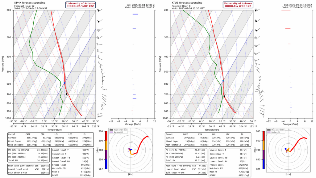
The question for today is what locations will get enough clear-sky to reach the convective temperature? (about 99°F in Phoenix and 86°F in Tucson). Storms that do form in and around Tucson in the early afternoon will move west and avoid the areas from Casa Grande to Phoenix that had storms overnight. The light rain in the forecast radar reflectivity for Cochise County and western New Mexico, shown by the HRRR-UA WRF 12Z below, is a result of Tropical Storm Lorena’s circulation.
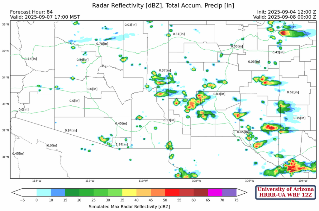
Tomorrow
What’s left of Lorena’s mid-level circulation passes by to the south of Arizona and the storms that form on the Mogollon Rim tomorrow afternoon will move southwest. Although not indicated by the forecast radar refelctivity, Phoenix and Casa Grande may also get stronger storms, given just a slight miss in forecast location.
Outlook
On Saturday, westerly winds will begin the process of ending the monsoon season. Storms form along the Mogollon Rim east into New Mexico, and some may push into Phoenix in the evening, but they should be much weaker and scattered.

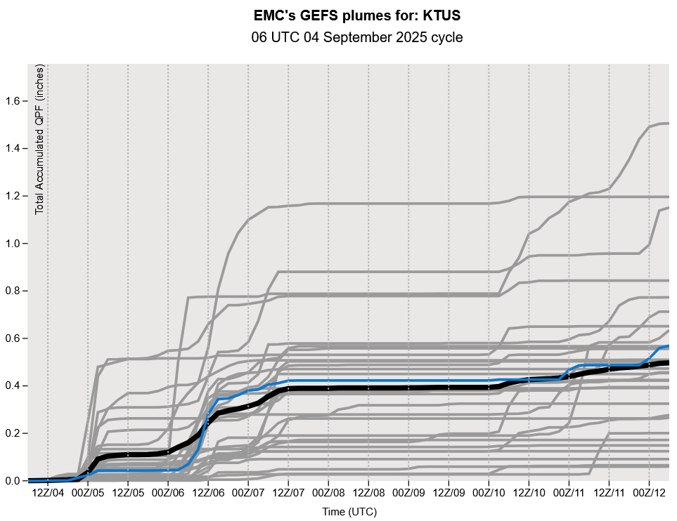
The GEFS plume forecast shows the monsoon is done on or around September 7th. The precipitation the following weekend, if it occurs, will be due to a cold front.
The forecast radar refelctivity for Sunday at 5pm shows the diminished storm activity.
Discussion written by Pat Holbrook and Patrick Bunn