
Yesterday’s Weather
Yesterday was a cloudy day for most of Arizona as we had day 1 of what is forecast to be a 3-4 day weather event as result of a low-pressure trough combined with tropical storms in the East Pacific. More details on the set up later, but the infrared satellite images show a sustained band of clouds coming into the region from the southwest. Showers were imbedded in this band of cloud, and the annotated lightning data shows where the updrafts were.
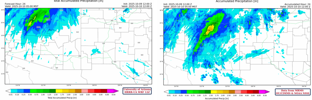
Shown below are the 24-hour accumulated precipitation forecast from yesterday’s HRRR-UA WRF 12Z (left) and equivalent observations from the MRMS system (right). A reasonable forecast in terms of intensity and spread of the precipitation accumulation, but the positioning was off with the maximum observed accumulations for the day in the Tonto River Basin at the intersection of Gila Yavapai, and Coconino counties, near Payson.
Analysis
A low-pressure trough is currently off the west coast, and a high-pressure ridge is centered over Chihuahua, Mexico, south of Big Bend, Texas. These two features have set up a jet of southwesterly flow across the region. Adding to the mix is tropical storm Prescilla, which has dissipated since the image shown below (valid for yesterday at 6pm). Despite the weakening of Prescilla, its clockwise (anti-cyclonic) outflow is advecting moisture into Arizona and will continue to do so as it fizzles out moving northeast.

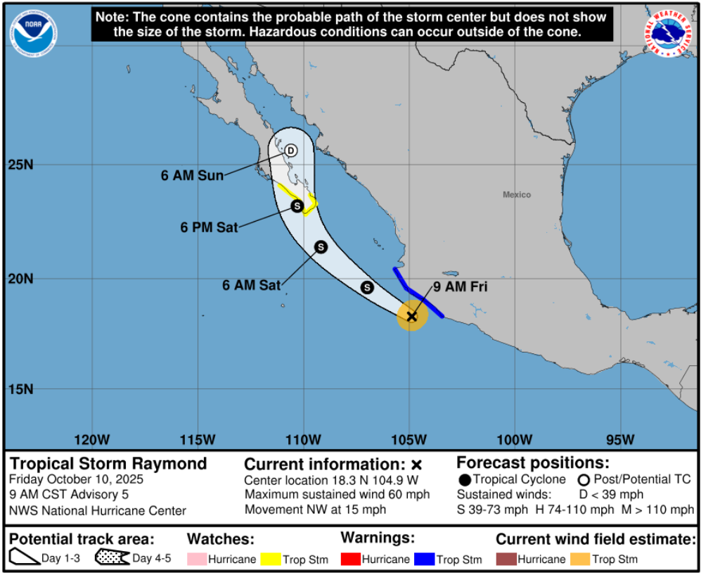
Also, another tropical system, Raymond, is forecast to push north in the wake of Prescilla, though further east, crossing the Baja Peninsula on Saturday night. This will push even more moisture north. Earlier this week, there were some wild forecasts for Southern Arizona, particularly from the GFS global model. The global models struggled with the exact timing of the trough moving through and the movement of dissipating Prescilla and Raymond causing some insane precipitation totals; I saw 14” for Nogales on a forecast on Wednesday. As we have approached closer to the event, forecast uncertainty has reduced, and the models have generally backed off in the total accumulated rainfall forecast.
Today through to Sunday the trough will move east, causing positive vorticity advection ahead of its path. Today and tonight, the southwesterly moving band of clouds from Prescilla outflow will continue, and the main impacts will be in Northern and Western Arizona. This is a slow moving synoptic-scale feature, so the band of clouds will slowly push south-east into Southern Arizona on Saturday with the main impacts forecast for the evening and early hours of Sunday morning. The upper-level divergence forecast for tomorrow, green contours shown below, illustrates a favorable environment for thunderstorm development where the streamlines are difluent. Combine this to moisture in place from the remnants of Prescilla and all the ingredients are there for a significant precipitation event. The NWS has a flood watch issued for most of the state for the next 36 hours.
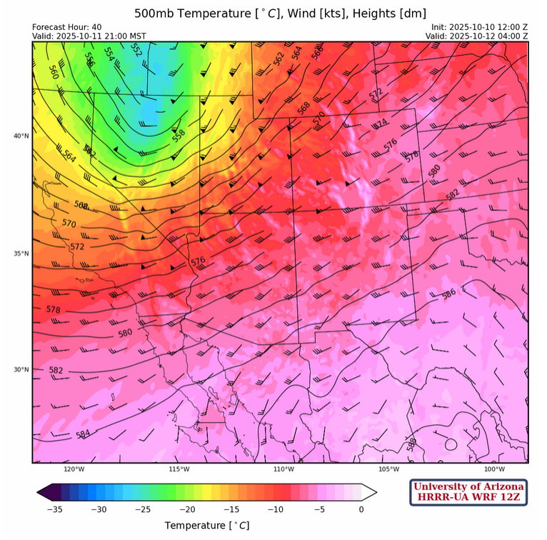
The 500mb forecast for tomorrow at 9pm shows the cold-core trough over Nevada, the ridge in Northern Mexico, and the southwesterly flow they are setting up across Arizona. Waves in the forecast lines of thickness in Northern Mexico indicate a prime location for thunderstorms.
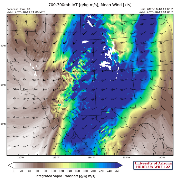
The integrated water vapor transport forecast for tomorrow at 9pm has a spectacular amount of moisture (>260 [g/kg m/s]) being advected into the Arizona/New Mexico and north into Utah, Wyoming and Colorado all from the combination of the trough moving through and the tropical storm moisture.
Today
The radar reflectivity for this afternoon shows a band of showers passing over Prescott, Flagstaff, and into Navajo and Apache counties. Overnight thunderstorms, embedded in this cloud feature, organize and are forecast to produce 1-1.5” of rain in these locations. The flow from the southwest will be orographically enhanced as it moves onto the Colorado Plateau.
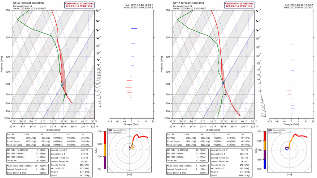
The forecast soundings for Flagstaff and Phoenix (below) show enough Convective Available Potential Energy (CAPE) in Flagstaff for thunderstorms, but a temperature inversion just above 800mb at Phoenix prevents any storm development despite a good amount of precipitable water 40mm (1.5”).
Tomorrow
The forecast soundings for tomorrow evening for Tucson (left) and Phoenix (right) at 6:30pm show an impressive 800 [J/kg] of CAPE for Tucson and over half that for Phoenix. That, coupled to precipitable water over 40mm at both locations, means thunderstorms are possible in the afternoon and likely into the evening.

The forecast radar reflectivity for tomorrow shows the cells are less organized in the afternoon than the forecast for today in Northern Arizona and they are moving fast, therefore, reducing the flooding potential unless there’s training of storms where isolated cells hit the same region over and over again. By the early hours of Sunday morning, a band of showers moves into SE Arizona, associated with outflow from Raymond. This band is more organized and has greater potential to cause flooding for Santa Cruz and Cochise counties.
As mentioned earlier, the precipitation accumulations have backed-off considerably over the past week, and there are still tomorrow morning’s forecasts to come. Still 0.25”-0.5” accumulations are predicted for Tucson and Phoenix metro, and greater amounts on the mountain to the northeast of both cities. The exact amount will depend on how many thunderstorms directly hit either city. These forecast amounts are still enough to cause flooding if rainfall is widespread in the metro area and the persistent nature of this event will aid in that likelihood.

Outlook
On Sunday, the system will continue to track east and continue to affect Cochise County and east into New Mexico. Remnant moisture from Raymond will come into play, though the forecast for Raymond is still quite uncertain at this lead time. Precipitation totals are in the 0.5”-1” range for El Paso, with much greater totals south into Northern Mexico.

Discussion written by Pat Holbrook and Patrick Bunn