
Yesterday’s Weather
Storms formed on the Mogollon Rim in the afternoon and, with a push from easterly winds aloft, swept west and southwest into Maricopa, Pinal, and western Graham counties. The storms then moved into western Arizona before weakening. This was mostly a high wind event as gusts near 60 mph occurred in these counties along with blowing dust. The rain that fell was not too heavy away from the mountains as the storms moved quickly west. Southern Arizona saw only light showers along the international border associated with a mid-level cloud deck. Additional storms developed overnight in far western Arizona and have moved into California.
The 24-hour accumulated precipitation forecast from yesterday’s HRRR-UA WRF 12Z (below, left) is compared to the equivalent observations from MRMS (below, right). Let’s break this down into the areas where the model did well first: New Mexico, southern Arizona, and far northern Mexico.

However, in the rest of Arizona, the model forecast developed storms in the White Mountains and Mogollon Rim around 2pm, but did not predict the intensity or the movement of the storms into the low desert areas correctly (as shown by the radar comparison below; forecast left, observations right). Without in-depth analysis, we can only speculate why the model performed poorly. Not having an Albuquerque sounding at 12Z (5am), where temperatures at 500mb were close to -8°C, was likely a factor.
Analysis
The surface dewpoint observations show there has been an increase in moisture from Nogales to Phoenix, and west into California associated with the thunderstorms and outflows in these areas. It is a little bit drier in eastern New Mexico compared to the weekend, and easterly surface winds are present from El Paso west into Arizona which is usually bring dry air west.

Both the observed sounding at Phoenix from 5am and the HRRR-UA WRF 12Z initialization are similar with the model initialization showing slightly more precipitable water than the observed sounding (~2mm). The mid-level wind speed is still higher than normal and thermal wind is from the southeast around 18 knots.

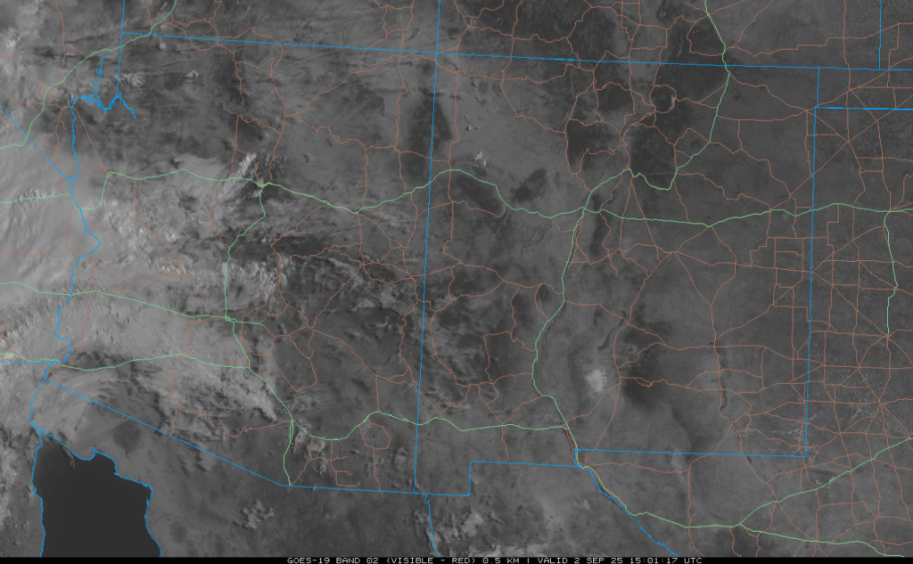
The GOES-19 visible satellite image from this morning shows a cloud-free New Mexico and increasing cloud cover across the western half of Arizona with showers and thunderstorms in western Arizona and California.
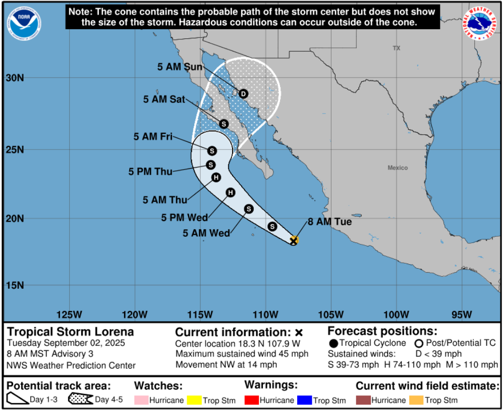
To the south, Tropical Storm Lorena is moving northwest at 18 knots and will intensify to a hurricane by tomorrow. There is a significant difference between the ECMWF and the GFS forecast position of this tropical system by Thursday night. It’s odd, the GFS brings the storm into Mexico on Sunday, while the ECMWF strips the mid-level moisture from the storm and the low-level center moves west into the Pacific. The forecast track is slightly changing at each new initialization, and slight changes in the direction and track can mean Tucson gets rain versus it missing to the east of Tucson. In general through, the ECMWF brings more rain scattered over Arizona, whereas the GFS has more rain following the predicted track of Lorena. The National Hurricane Center forecast is below.
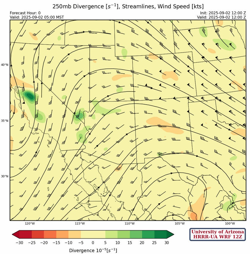
At 250mb, the sub-tropical ridge is now over central Mexico, with a trough off the west coast. Wind speeds have dropped about 10 knots across the region.
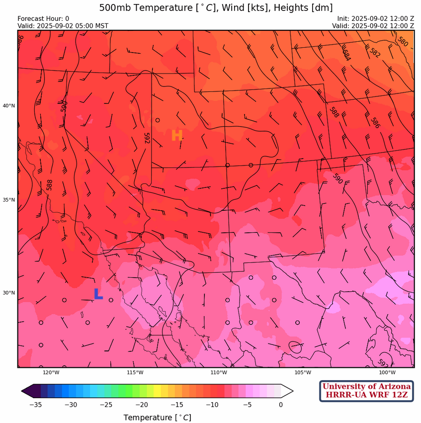
The ridge is over Utah at 500mb this morning with easterly flow across the region. Low pressure is south of San Diego and is moving west.
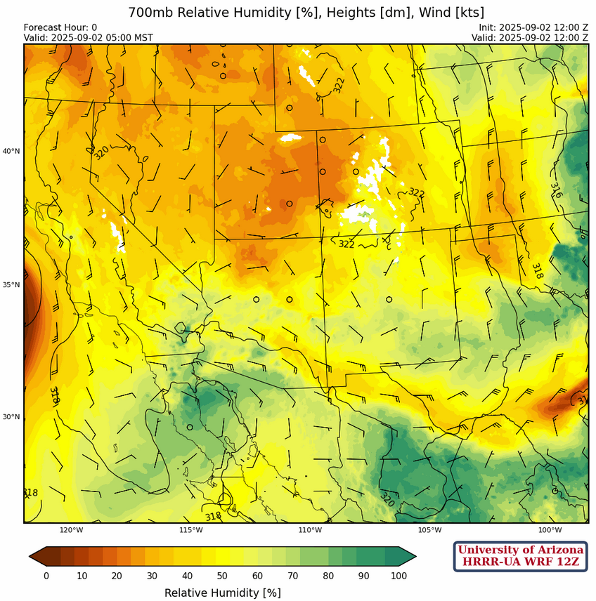
At 700mb, dry air continues to move into New Mexico and to the eastern half of Arizona in the wake of the storms yesterday. The 700mb dewpoint temperatures at both Phoenix and El Paso are -1°C compared to yesterday when the dewpoint temperatures at Phoenix and El Paso were +1°C and +6°C, respectively.
Today
The HRRR-UA WRF 12Z forecast soundings for Tucson at 2:30pm (left) and Phoenix at 5:30pm (right) show low amounts of Convective Available Potential Energy (CAPE) at the time when Convective Inhibition (CIN) is at it’s daily minimum. Knowing that 700mb dewpoint temperatures are low, neither of these soundings would support thunderstorm development today.

To our south, the forecast sounding for Nogales at 2pm (below, left) has a little CAPE and no CIN this afternoon. Storms that develop there are probably meant for central Pima County, as the easterly mid-level flow would push them west as indicated by the forecast sounding for Lukeville at 5pm (below, right) that has much more CAPE and would support strong thunderstorms.

The HRRR-UA WRF 12Z forecast radar reflectivity shows thunderstorms developing in a band from Nogales to just west of Tucson then west to central Pima County and almost to Yuma. The storm motion will be to the west or southwest as the storms will not move into the area with the lower dewpoint temperatures (the Sun Corridor between Tucson and Phoenix). The strongest wind gusts, up to 50 mph, will be in western Pima and southwest Maricopa counties and near the Colorado River near Lake Havasu City.
Tomorrow
Tomorrow is forecast to be a replay of today as there is not much difference in the location of the moisture across the state. A slight increase in moisture is forecast for the Mogollon Rim and the forecast radar reflectivity shows storms along the mountains and in central and western Pima County.
Outlook
The exact track of Tropical Storm Lenora will have a big influence on the impacts it will have on Arizona. Regardless of the track, upper-level divergence should be at its best on Thursday afternoon/evening and storms are forecast to develop in the Tucson area and move northwest to Phoenix with strong gusty winds and blowing dust.

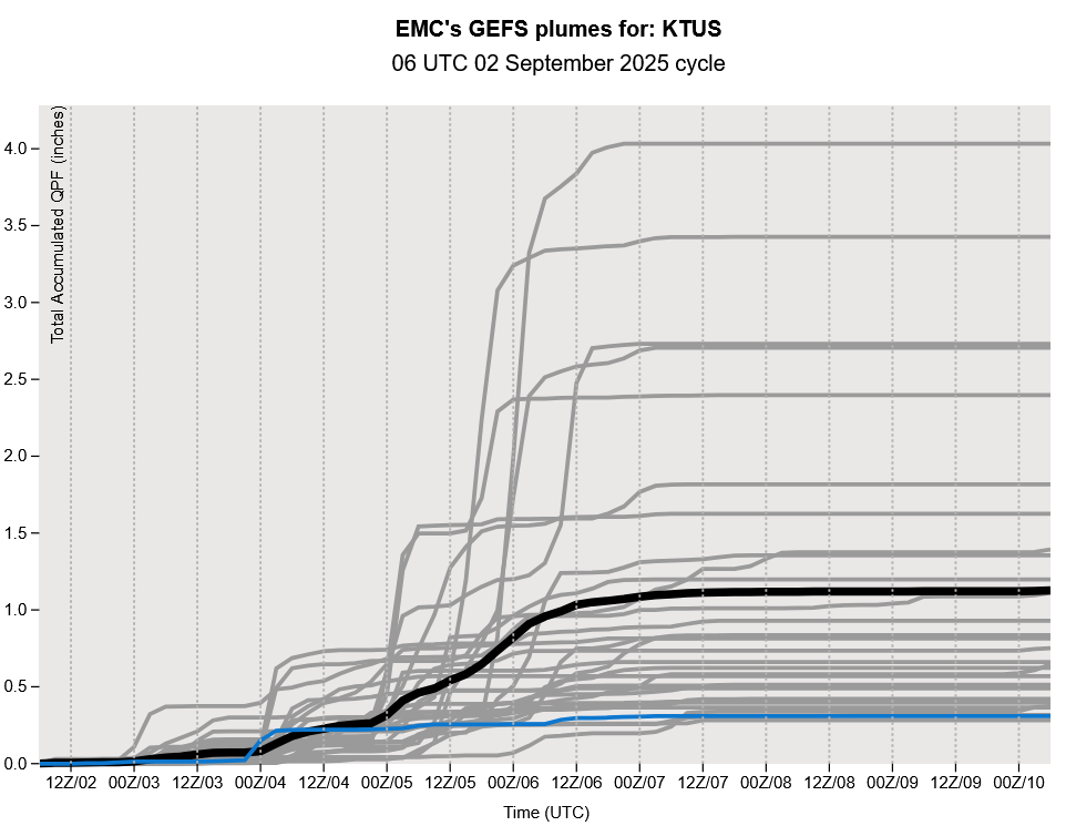
The GEFS plume forecast shows impacts from Tropical Storm Lorena are extremely uncertain as a wide variety of precipitation amounts are predicted. In general, the closer to the center of the storm, the higher the forecast precipitation amount. The good news is that there are a few more days to prepare for the storm and in that time forecast track uncertainty should reduce.
Discussion written by Pat Holbrook and Patrick Bunn