
Yesterday’s Weather
Yesterday, Tucson was hit with a strong microburst as captured by our cloud camera. The sub-tropical high, or monsoon ridge, is well to our south in Mexico so we are not in a monsoon flow pattern. Instead, Arizona was in a region of weak upper-level divergence, between two troughs, one off the west coast and one impacting the mid-west. This coupled to the moisture in place and the synoptic scale push from remnants of tropical storm Mario aided in thunderstorm development yesterday. It was highly uncertain as to whether the storms could develop in spite of the mid-level cloud cover, but the favorable wind shear meant storms that persisted on the Catalina mountains eventually propagated to the south.
The Rainlog 24-hour precipitation totals show that around 1.5” fell in mid-town Tucson, and Marana got over 0.5” and Oro Valley over 0.25”.

Shown below are the 24-hour accumulated precipitation forecast from yesterday’s HRRR-UA WRF 12Z (left) and observations from MRMS (right). The doughnut hole around Tucson, was the big miss in the forecast and elsewhere the main activity was along the Arizona/Mexico border and in the higher elevations of New Mexico.

Zooming into just Pima County, we see the forecast totals for the Catalina’s and central Pima County were reasonable, but the storms in western Pima County and Tucson metro were missed in the forecast.

Model forecasts earlier in the week captured the event better, but closer to the event the forecasts backed off. The animation below shows the precipitation accumulation forecasts through to 8pm yesterday. The best forecast being from HRRR-UA WRF 12Z on Tuesday 16th, so the day-ahead forecast.
Today
The atmosphere is likely worked over from the storms yesterday, so there are less chances of a similar event today. The HRRR-UA WRF 12Z forecast sounding shows there is enough precipitable water and Convective Available Potential Energy (CAPE) today, but the mid-level wind means storm propagation will be to the north-east.
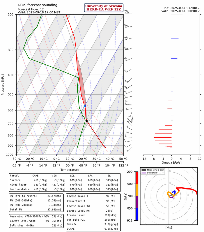
The best chance of storms reaching Tucson will be from cells forming on the Tucson mountains and south to Green Valley, moving north/east in the early evening.
Tomorrow
Tomorrow the outflow from remnants tropical storm Mario comes into the region from the southwest. It aids in storm development between Phoenix and Flagstaff, and the White Mountains, tomorrow morning. There are greater chances of precipitation for the Tucson metro area tomorrow, as an isolated cell in this southwesterly flow could result in a direct hit to the Tucson metro area.
The 48-hour precipitation accumulation forecast from HRRR-UA WRF 12Z, shows over 1” of rain for the complex terrain near Prescott and also on the Mogollon Rim. Slightly less for the mountainous regions of southeast Arizona. The stronger CAPE, compared to today, means storms will initiate on the mountains and the southwesterly flow will propagate them away from the mountains. The strong flow means flash flooding is less likely, unless there’s training of storms, where cells form over the same area repeatedly.

Discussion written by Pat Holbrook and Patrick Bunn