
Yesterday’s Weather
Thunderstorms formed about where the model forecast yesterday given the observed radar reflectivity shown below, though there were stronger storms in the White Mountains and northern New Mexico.
An isolated storm popped up in northeast Tucson and dropped a couple of tenths in a small area.
The main story was the heat with high temperatures well into the triple digits across most of the state and overnight low temperatures staying high. Phoenix “cooled” off to a overnight low of 93°F, while Tucson at the airport was 81°F and on UofA campus 80°F.

Analysis
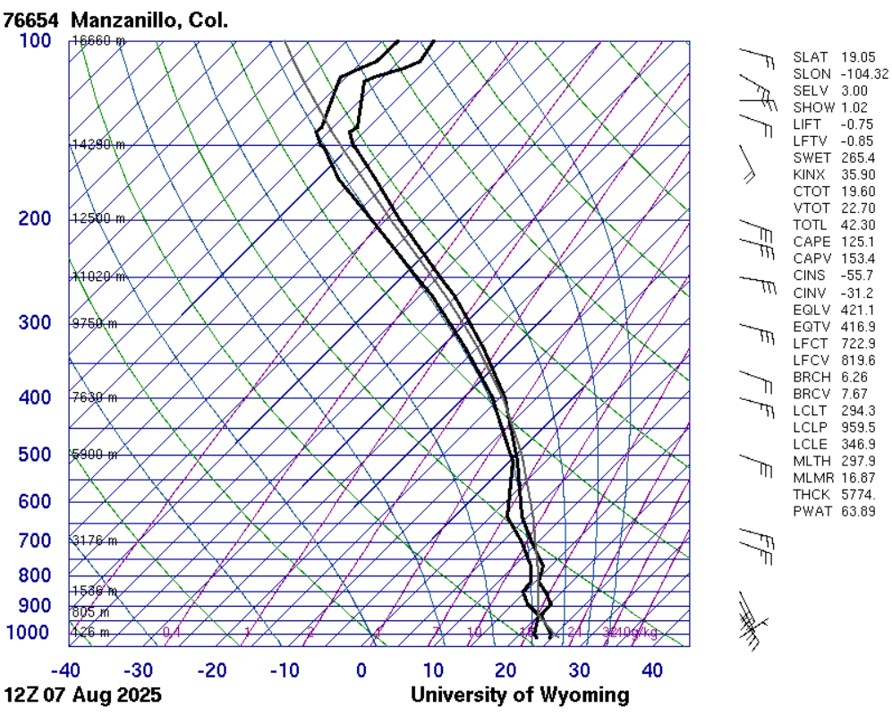
The sounding below is from Manzanillo, Mexico, which is about 60 miles northeast of the current location of tropical storm Ivo. The precipitable water is 63mm (2.4 inches) and while that much precipitable water won’t get into Arizona, the cyclonic (anticlockwise) flow around the storm will push a significant amount of moisture to the north.
A gulf surge is still not showing up in the soundings from Mazatlán, Empalme (Guaymas), or La Paz. Mazatlán shows almost 3 inches of precipitable water and significant cooling from 700mb to the surface (below, left), this is due to thunderstorms along the coast that moved into that area. Will this help initialize the surge? We will find out tomorrow if the surge is up to the Empalme (Guaymas) area.

The National Hurricane Center has a public advisory for tropical storm Ivo (shown below). It’s currently 300 miles from Acapulco, with sustained winds of 45 mph, and a movement speed west at 24mph. A relatively fast speed for a tropical system, over 500 miles in a day.

Ivo will become a Hurricane as it passes well to the south of the southern tip of Baja.

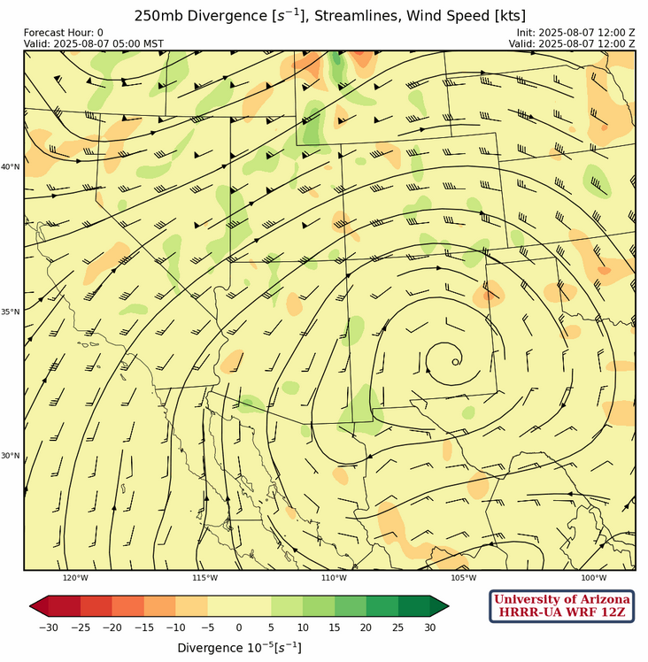
At 250mb, the sub-tropcial ridge is now over southeastern New Mexico with another trough dropping into Oregon and northern California. Winds are southerly across Arizona, 10 knots in the southeast and 30 knots in the northern part of the state. New Mexico has westerly winds at 20 knots across the northern part of the state turning to easterlies underneath the ridge.
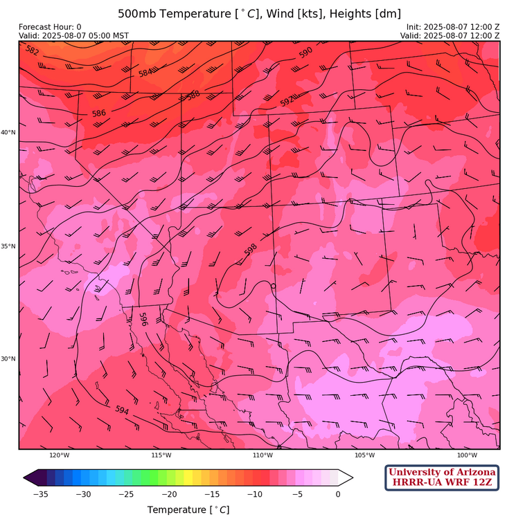
The ridge at 500mb is vertically stacked with the 250mb ridge over southeast New Mexico with generally southerly to southwest winds around the ridge axis that extends across the middle of the region. The cooler temperatures indicated from Yuma to Phoenix and north to Flagstaff is a real feature as soundings show temperatures at -8°C.
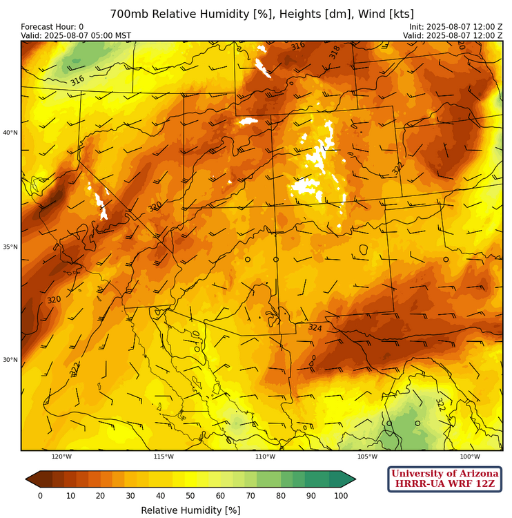
At 700mb, a plume of dry air from west Texas into northern Mexico is consistent with obervations as Midland, Texas had a dewpoint temperature of –13°C this morning. The dry plume may suppress storms in southeast Arizona this afternoon, but the spine of the Sierra Madre’s, specifically the west side, should have strong storms which move up to the international border overnight. That said, the overall pattern today is less storms than yesterday.
Today
The forecast radar reflectivity for this afternoon looks just like yesterday with storms in the mountains, north of the ridge axis, and a somewhat suppressed atmosphere in southeast Arizona. There will be strong wind gusts associated with the stronger storms, shown in the 10 meter wind speed forecast below.
Tomorrow
HRRR-UA WRF 12Z forecasts show a surge of moisture moving into southern Arizona tonight. This may be a result of a large thunderstorm complex developing on the spine of the Sierra Madre’s this afternoon moving west, and thus initializing a surge. The 10 meter wind speed forecast shows strong southerly winds up the Gulf of California.
Radar reflectivity and wind speed forecasts for late afternoon tomorrow shows storms developing in southeast Arizona and moving west. They seem to stop just west of Tucson, possibly due to less convective available potential energy (CAPE) over the low desert regions as a result of cooling in the boundary layer from the surge.
Outlook
On Saturday evening, the forecast gets more complicated as the trough over the intermountain west, currently to our northwest, brings southwesterly flow. The radar reflectivity forecast on the left below is for Sunday morning at 3am and thunderstorms east and north of Tucson extend to cover most of New Mexico. Sunday night forecast, below on the right, show storms develop near Prescott and Flagstaff in response to the trough dropping southward. Some storms up by the Grand Canyon, hopefully helping with the wildfire.

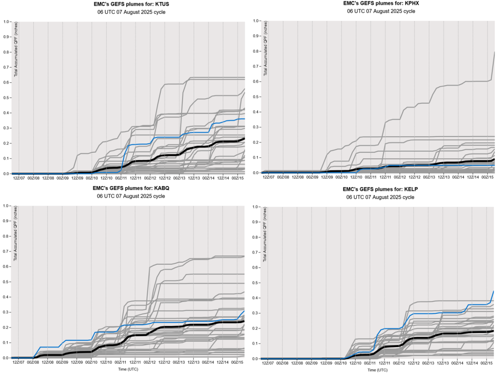
The GEFS plume forecast below for Tucson shows chance of precipitation almost every day from Saturday through to August, 15th, showing that we are heading back to a more active monsoon period!
Discussion written by Pat Holbrook and Patrick Bunn