
Yesterday’s Weather
New Mexico was still the focus of the convective activity especially across the central portion of the state where the jet stream dynamics were the most favorable. Storms also formed in southwest New Mexico and southeast Arizona. A flash flood watch remains in effect for most of New Mexico through Wednesday. A few showers were also in the Tucson metro, but very little precipitation reached the ground. The western two thirds of Arizona was mostly clear with southerly winds gusting to 30 mph in the higher locations.

Analysis
The upper level water vapor satellite image below shows the tropical upper tropospheric trough (TUTT) and upper lows along the TUTT forming off the east coast of Florida down to Mexico City. A developing tropical system south of the Gulf of Tehuantepec shows the beginning of an upper-level anticyclone over the tropical system. The anticyclone will aid in the development of the tropical system as its outflow intensifies once its interacts with the circulation of the TUTT low to the north. This storm system should push moisture northward, as suggested in longer range model forecasts around July 4th.
At 250mb, strong southwest winds are still dominating the region. But the core of the polar jet has moved farther north, meaning the favorable synoptic dynamics of yesterday have passed.

At 500mb, temperatures over Arizona have cooled off slightly, but remain the same over New Mexico. The wind remains strong from the southeast.

At 700mb, the moisture axis is from Chihuahua northward to central New Mexico where it connects with a front and the moisture streams northward to the North and South Dakota. The front/moisture is shown on the upper level water vapor satellite image extending east to New York.
Today
The simulated radar reflectivity forecasts from UA WRF with HRRR initializations show that although the storms are in the same general location as yesterday’s storms, there is a decrease in intensity and areal coverage from yesterday.
The total precipitation image below that shows the storms mainly on the mountains. Arizona, except for the far east near Springerville, remains dry and even the surface winds are weaker than yesterday as the trough, and associated jet, moves out of the region. Temperatures are starting to rise again as the moisture is leaving.

Tomorrow
Even fewer storms in New Mexico forecast for tomorrow as the flow of monsoon moisture weakens. There are actually a few more storms in the White mountains, but little precipitation expected on the ground. Still, all of these storms will produce lightning, therefore have the potential to start fires.
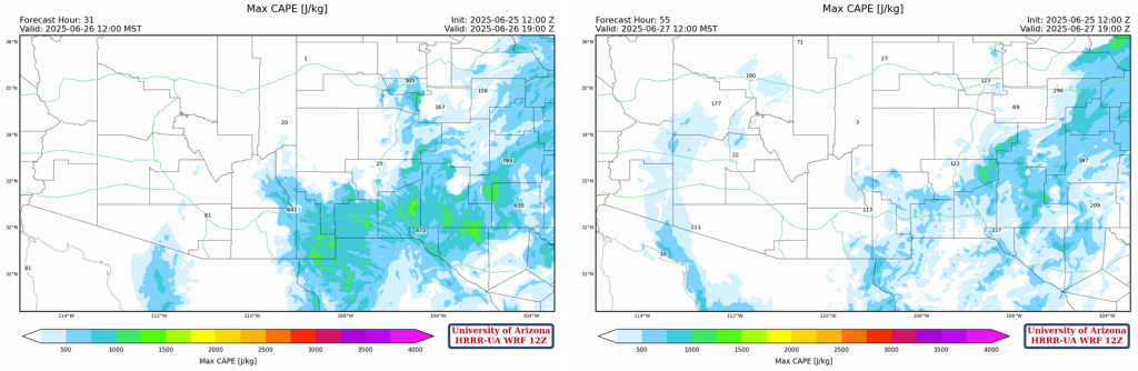
Outlook
The models continue to agree upon a warming trend over the next week, with an increase temperature of 2 degrees F. New Mexico will also dry out over these days, with decreasing rain chances throughout the week. The CAPE maps below are for Thursday and Friday at noon. The CAPE values off the Gulf of California on Friday is not a gulf surge as it will mix out into the dry air throughout the day.
Discussion written by Pat Holbrook