
Yesterday’s Weather
The satellite imagery animation from yesterday shows convection start in the early afternoon, with thunderstorms first on the Tohono O’odham Nation Reservation moving east to I-19, then two rounds near Phoenix: first to the northeast, then to Phoenix’s southwest. Anvil tops were blowing northeast.
At 10pm yesterday the observed composite radar reflectivity (below, left) shows thunderstorms forming mostly north and east of interstate 10 in Phoenix and by 3am (below, right) storms were in northwest Pinal County.
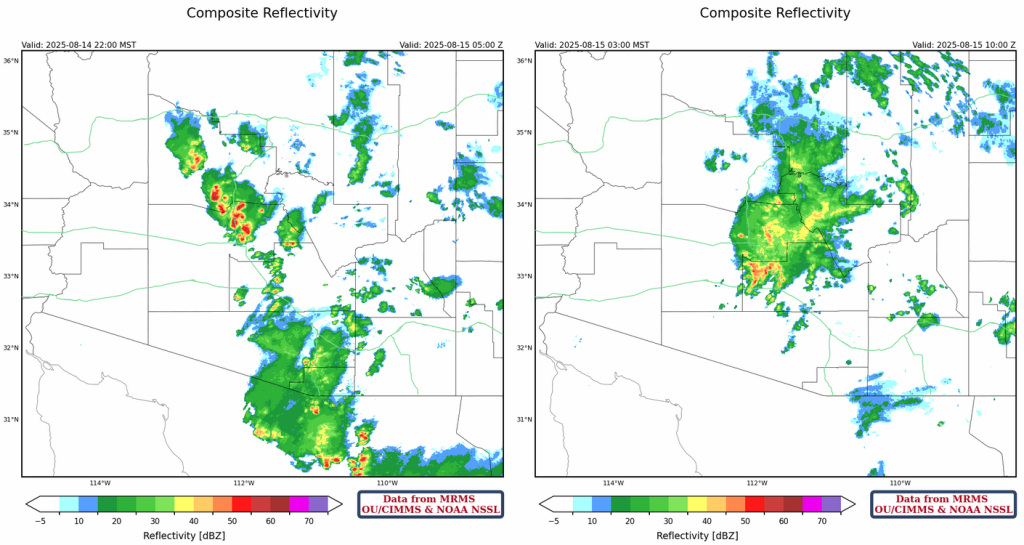
Rainlog data shows the precipitation in and around Phoenix, but note that only one rain gauge had data in Pinal County.
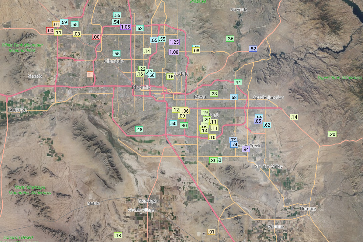
Further south, the greatest rain totals were along the I-19 corridor from Nogales to just south of Tucson. In Tucson metro, only light rain fell during the night around 4:30am.

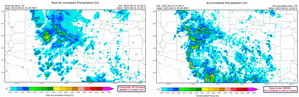
The MRMS 24-hour accumulated precipitation product (below, right) gives a good overall view of the observed precipitation totals where there aren’t Rainlog gauges (on the mountains and remote deserts). From this product, the 1.5″+ inches of rain that fell in northwest Pinal County stands out.
Analysis
The satellite image for this morning shows a broad area of clouds over central/eastern Arizona and western New Mexico is being pulled northward across Arizona.

The moisture surge is not a gulf surge, as is a result of the trough in California and monsoon moisture that was already was in-place in Mexico. Note the 50°F and 60°F dewpoint temperatures are much further north today.

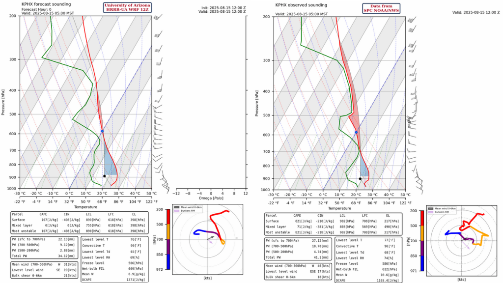
The Phoenix observed sounding for 5am this morning (below, right) is difficult to interpret as the storm activity may not reflect the area around the sounding. Compared to the HRRR-UA WRF 12Z initialization (below, left), both soundings have a similar structure as far as moisture and precipitation. The model has smoothed out the winds above 450mb as this was affected by the storms, and does not have the moisture around 700mb associated with the clouds. But, remembering that the model sounding represents the area in general and the observed sounding is just one point in space, the model initialization is good.
The tropical upper tropospheric trough (TUTT) axis is indicated on the GOES19 water vapor satellite imagery below, with a TUTT low over the southeast Gulf of Mexico and an anticyclone over Hurricane Erin.

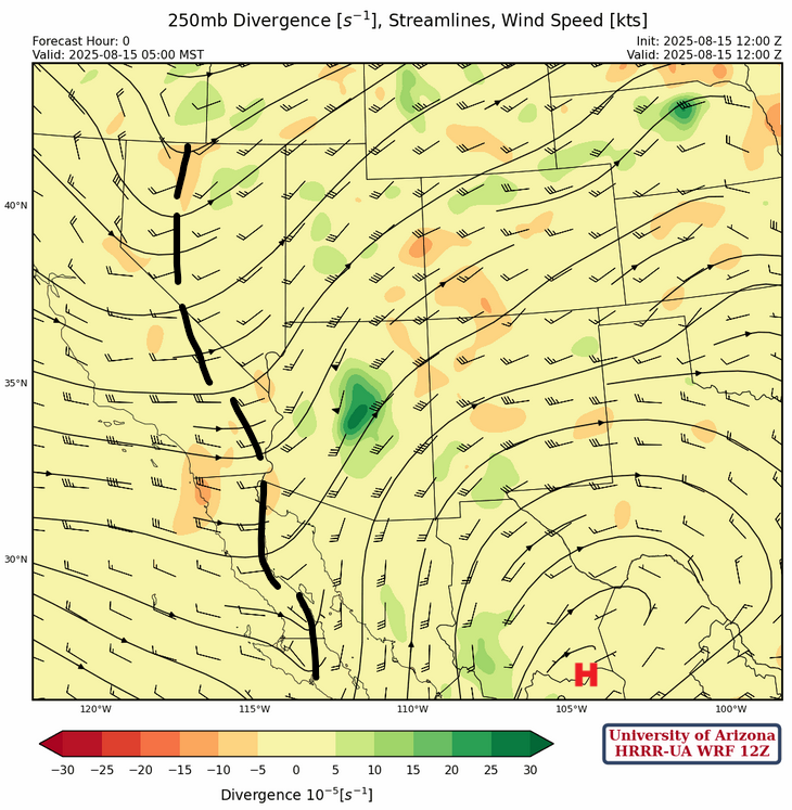
At 250mb, a trough extends from northern Nevada southward to the Gulf of California and the ridge south of the Big Bend of Texas. Winds are southwest with a 50 knot jet max over central Arizona.
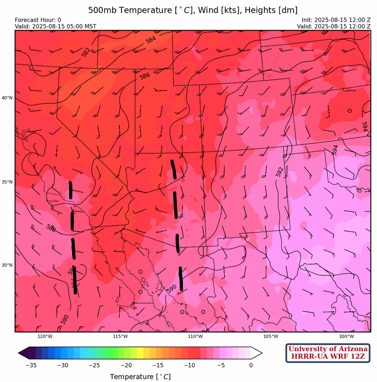
A couple of short-wave troughs are rotating through the long-wave trough at 500mb as shown below. High pressure is located over Kansas with broad southerly flow over New Mexico and east of the trough in Arizona. Temperatures aloft are close to –9C west of the trough in Arizona.
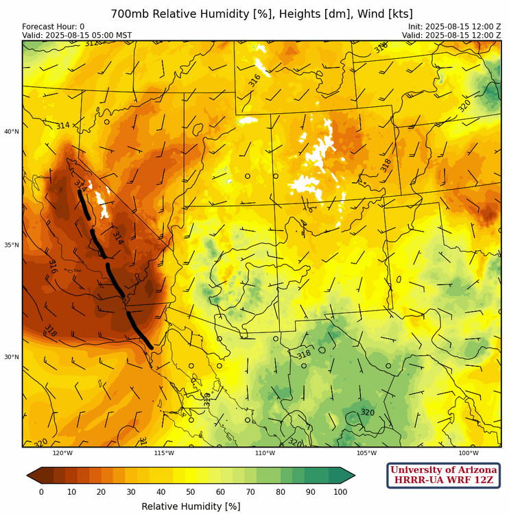
At 700mb, a trough is over southern California and northern Baja with dry air in California and moist air in Arizona. This trough does not move much for the next few days and moisture increases over the region due to convection. The tropical system off the Texas coast moves northwest to the Midland/Southeast New Mexico area in the next 72 hours.
Today
The forecast soundings for Tucson and Phoenix this afternoon at 4pm are below. They show that the atmosphere will not need hot temperatures to initiate thunderstorms. Also given this environment, storms can occur either day or night and contain heavy rain as movement will be slow and the possibility of training of storms (one after another in the same location) is likely.

The location of precipitation will be influenced by cloud cover and this morning the Tucson area is clearing out and the sun is shining. The cloud cover comparison, shown below, has the HRRR-UA WRF 15Z cloud cover clearing so is likely the better forecast today.

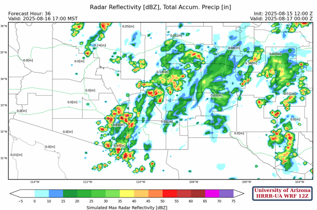
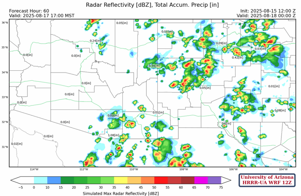
Still the general pattern of the radar reflectivty forecasts for HRRR-UA WRF 12Z and 15Z are similar for the Tucson area; convection starting in the early afternoon and rainfall starting before sunset. Similar to yesterday, storm tops will move to the the northwest, and Phoenix and Flagstaff get thunderstorms in the early evening (about 8pm on).
The main thing is the accumulated precipiation totals have backed off compared to the forecasts from the past two days, particularly in Pinal and Graham county. HRRR-UA WRF 15Z has rain for Tucson area ranging from 0.1″ to 0.5″, with the greater totals further south and west of the metro area in areas of higher elevation.

Tomorrow
A Mescoscale Convective Vortex (MCV) will be in southwest New Mexico tomorrow afternoon, with the thunderstorm activity focused in the cloud free area around the edge of the MCV. These thunderstorms may move into the Phoenix area during the evening.
Outlook
Model forecasts hint at some dry air moving into western Arizona from the trough in California. But this will probably not shutdown thunderstorms. The forecast radar reflectivty for Sunday show some thunderstorms on the Sky Islands in central Arizona eastward to New Mexico. For New Mexico, the added complexity in the forecast is the tropical system moving into far southeast New Mexico Sunday and it could enhance precipitation late Sunday into Monday in that area.
The GEFS ensemble plume forecasts for Tucson (left) and El Paso (right) below indicate the next couple of days will be the best chance of rain for Tucson. As for El Paso, the high variability on the 17th/18th maybe uncertainty attached to the influence of the tropical system by Brownsville.

Discussion written by Pat Holbrook and Patrick Bunn