
Yesterday’s Weather
The infrared satellite images show the initialization and progression of thunderstorms across western New Mexico and into Arizona. A dry air mass was over both eastern New Mexico and western and far northern Arizona, thus fewer storms. The storm movement was toward the west around 15 knots, south of the ridge center that is just south of the four corners. The thunderstorms in Arizona moved further west yesterday compared to Tuesday, and storms made it into Tucson, but only to the outskirts of Phoenix. Most of the storms ended around midnight and devolved into lingering showers.
Rain guage observations from Pima County Regional Flood Control show that little if any rain fell in central and eastern Tucson, but storms that developed over the Catalinas moved west and dropped quite a lot of precipitation. Parts of Marana and Oro Valley got about 0.5″. The lightning that was produced by the cell over Marana was particularly impressive.
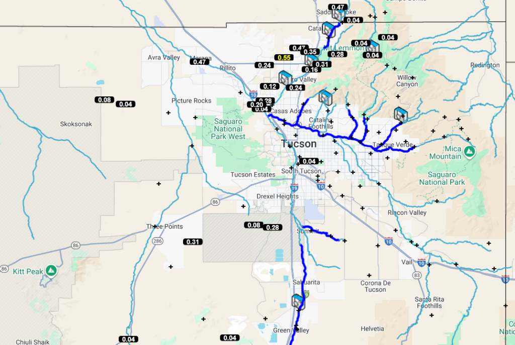
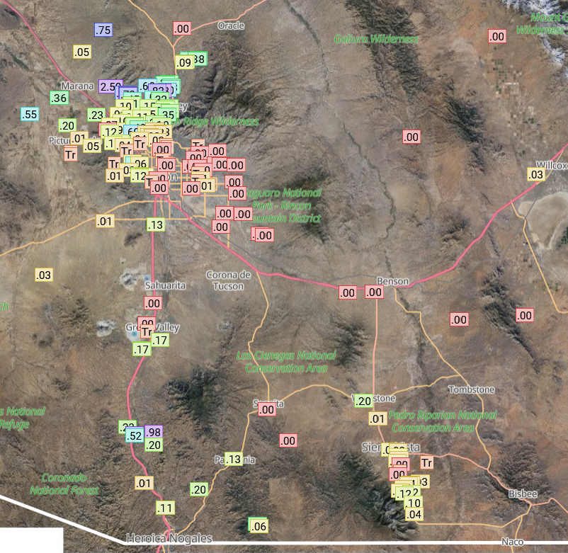
The Rainlog data for southeast Arizona shows rain also fell along I-19 south to Nogales and in the Sierra Vista area.
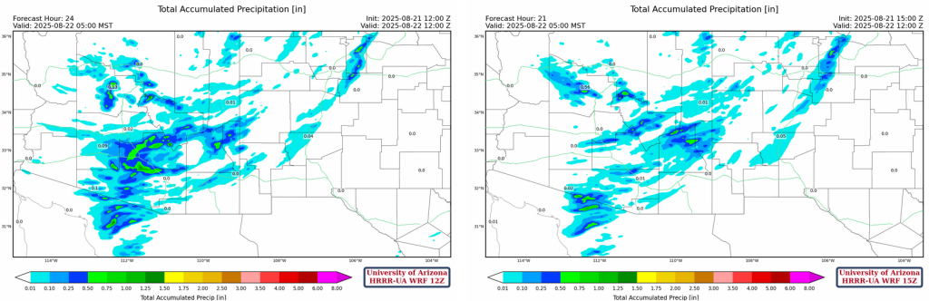
The forecast from yesterday (HRRR-UA WRF 12Z, left) is compared to MRMS 24-hour accumulation data below (right). A good forecast in terms of the spatial distribution of precipitation, though some of the greatest totals were a little weaker in the forecast.

Analysis
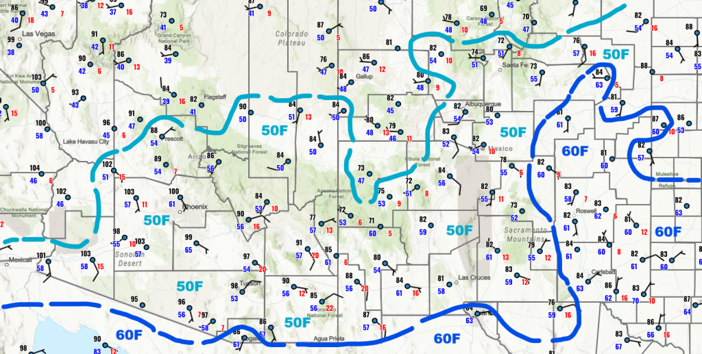
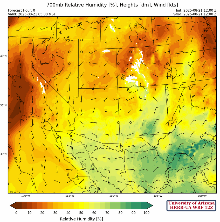
The 50°F isodrosotherm has been suppressed south in southeast Arizona as a reflection of the dry low-level moisture rotating around the high pressure center to the north. Dewpoint temperautre increases have occurred from Phoenix southward to central Pima county because of last night’s storm activity.
The low-level moisture satellite images below show the dry air wrapping around the high south of the four corners region. The good news is that we are still moist at the 700mb level across central and eastern New Mexico allowing storms to develop on the mountain there and into Arizona. The net effect is that over the course of a few days the mid-level moisture will be depleted due to mixing leading to more isolated storms. Today should therefore be the best day for thunderstorm in central Arizona.
The observed upper air souning for Phoenix at 5am (below, right) shows precipitable water has increased to 1.75 inches which is consistent with the HRRR-UA WRF 12Z model initialization (below, left). The easterly winds in the 700 to 500mb level will force storms to move off the mountains into Phoenix in the evening.

The tropical upper tropospheric trough (TUTT) seems to have broken in two as the anticyclone associated with Hurricane Erin has disrupted the TUTT circulation. The TUTT low in the Atlantic has moved northwest while the TUTT low along the east coast has drifted eastward. The remaining TUTT low in Mexico hasn’t moved much.

The high pressure ridge at 250mb is just south of the four corners with the TUTT and TUTT low far to the south. Anticyclonic flow dominates the region.

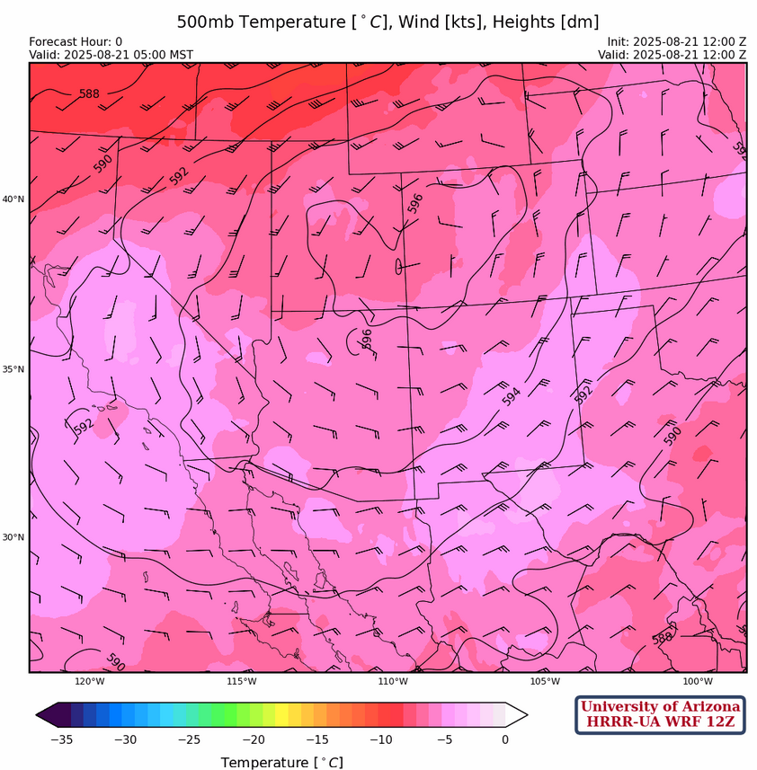
At 500mb, the center of the ridge is just to the north of the four corners with general easterly flow across the region. Temperatures are around –5°C across the Arizona and New Mexico, and this is not forecast to change significantly over the next few days.
Some drying is indicated in the 700mb initialization in eastern New Mexico. But, the 4°C dewpoint line at this level extends from central New Mexico to north of Phoenix then to east of Yuma and south from there into Mexico. This high of dewpoint temperature is good for thunderstorm formation in the mountains and them being pushed off the mountains given the eastly flow we have set up by the four corners high.
Today
Comparing the forecast soundings for Phoenix at 2:30pm (left) and Tucson at 3:30pm (right) shows Phoenix is forecast to have Convective Avaiable Potential Energy at 1200 [J/kg] while the CAPE in Tucson is less than 300 [J/kg]. The CAPE forecast in Phoenix is the highest it’s been forecast so far this season! The total precipitable water for Phoenix is forecast at 1.5″ (39mm) and that is between the 75th and 90th percentile of the climatology record for this day of the year.

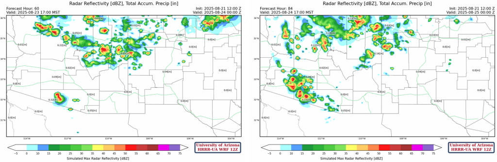
A squall line forms in Pinal County and moves west to the California border overnight. The strongest part of the storms stays just south of Phoenix and just north of Tucson, but both cities are close enough that any slight change in the forecast movement/location of the storms could result in a significant heavy rainfall event. Also, outflow from the storms will likely create dust storms or a haboob.
The precipitation totals through 5am from the two most recent UA WRF forecast (HRRR-UA WRF 12Z and 15Z) shows the heaviest rain just south of the Phoenix metro southward across Pinal County and into Pima County.
Tomorrow
The heavier precipitation shifts further west and north while lighter rain is in southeast Arizona and southern and Eastern New Mexico. Phoenix is still at significant risk of strong thunderstorms in the metro area then the thunderstorms will again move to the California border.
Outflows from the storms near Ajo will merge with outflows from Maricopa County near and west of the Palo Vere nuclear power plant with significant amounts of blowing dust from there to California.

Outlook
The low-level dry air will push the storms away from southern Arizona with the focus of precipitation in northern Arizona and New Mexico. There may be some storms in western Pima and southern Maricopa counties (Gila Bend) both Saturday and Sunday.
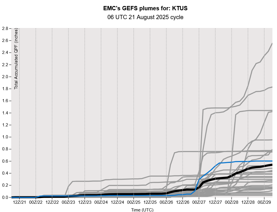
After a mostly quiet and hot weekend, precipitation is forecast to return next week looking at the GEFS plumes forecast for Tucson.
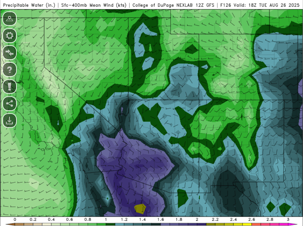
The precipitable water from the long-range GFS forecast shows moisture baclk in the region early next week.
Discussion written by Pat Holbrook and Patrick Bunn