
Yesterday’s Weather
Subsidence combined with a very dry-low level atmosphere forced most of the thunderstorms north of I-10 from Phoenix west to the California border and agreed well with the forecast. The low-level water vapor satellite loop shows dark blue to white shaded areas where storms were favored, while the yellow/red areas are too dry to support storms. Low-level pushes of moisture near the northern Gulf of California resulted in some storms in that area too. Overnight rotation of the moisture about the high pressure ridge has pushed the moisture boundary about 100 miles to the south in New Mexico and north about half as much in Arizona.
The gridded 24-hour accumulated precipitation map from MRMS is below on the right and shows most precipitation was less than a quarter inch with isolated one-inch amounts in the mountains. The precipitation in the Phoenix metro area was more like sprinkles, while the Prescott Valley had up to a half inch.

Analysis
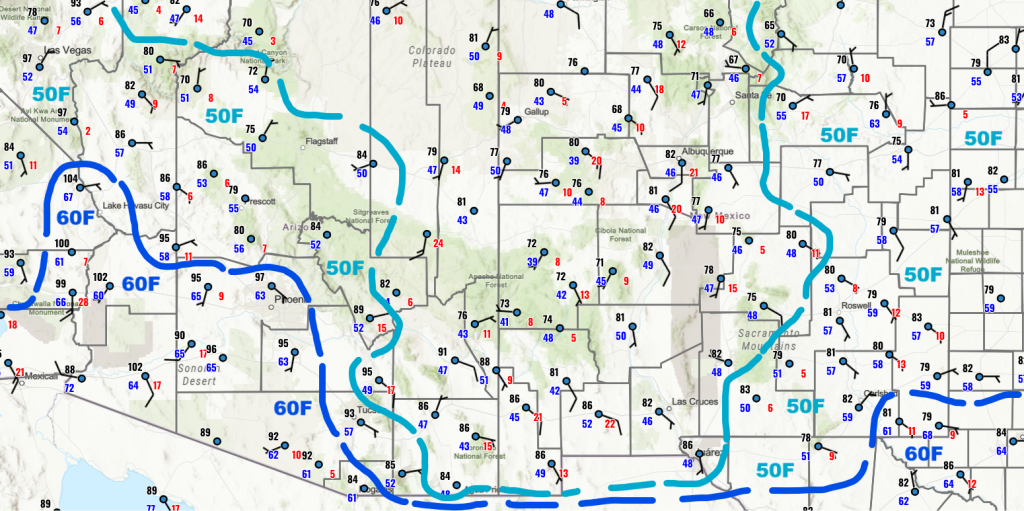
Looking at the surface dewpoint temperature observations from this morning, significant drying of the near-surface atmosphere has occurred, especially in eastern and southern New Mexico extending into southeast Arizona.
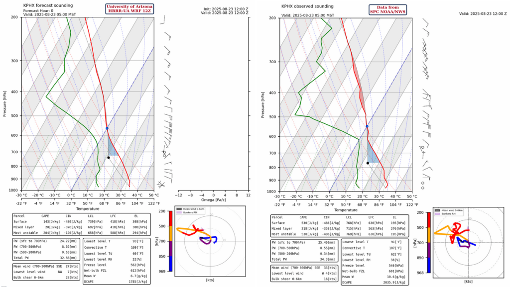
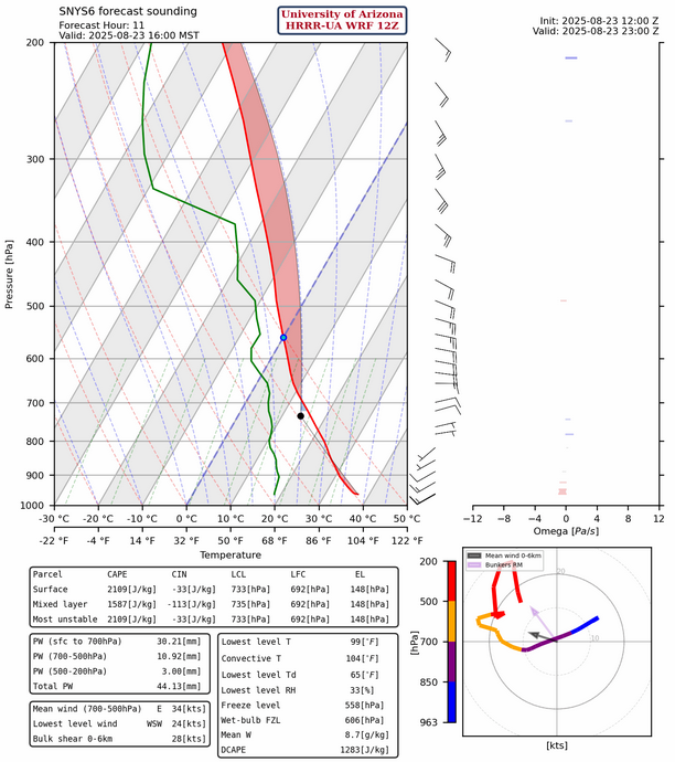
The observed sounding from Phoenix at 5am (below, right) shows less of a subsidence inversion than yesterday and precipitable water is a little higher than the HRRR-UA WRF 12Z initialization (below, left). This sounding would indicate thunderstorm development especially on the Mogollon Rim north of Phoenix and the thermal wind will have the storms moving to the northwest.
The visible satellite picture below shows mid-level clouds left over from last night’s convection rotating clockwise (anticyclonic) about the high pressure ridge center.

The tropical upper tropospheric trough (TUTT) axes has two branches, one over the southeast United States extending west to the central Baja and the other in the Atlantic and Caribbean Sea. The lows on the TUTT axes are annotated.

At 250mb, a trough is in the Pacific off the west coast of California. The TUTT to our south spans from Texas to the Baja. These two troughs may combine over the next few days. The high pressure ridge has stayed in about the same location as yesterday, but is being pushed on by the troughs. The high pressure subtropical ridge will eventually move eastward into Texas in a few days.

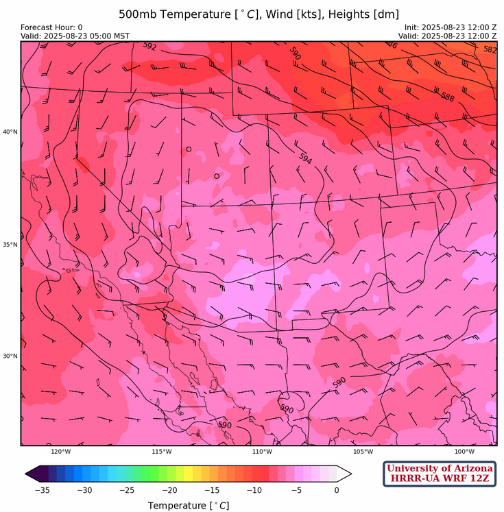
The ridge at 500mb has moved a little further north into southern Utah. Wind speeds have decreased underneath the ridge, so storm motion will be a little slower today. Warmer air is over southeast Arizona and will inhibit convection there. By tomorrow, cooler air from northeast New Mexico will move over southern Arizona.
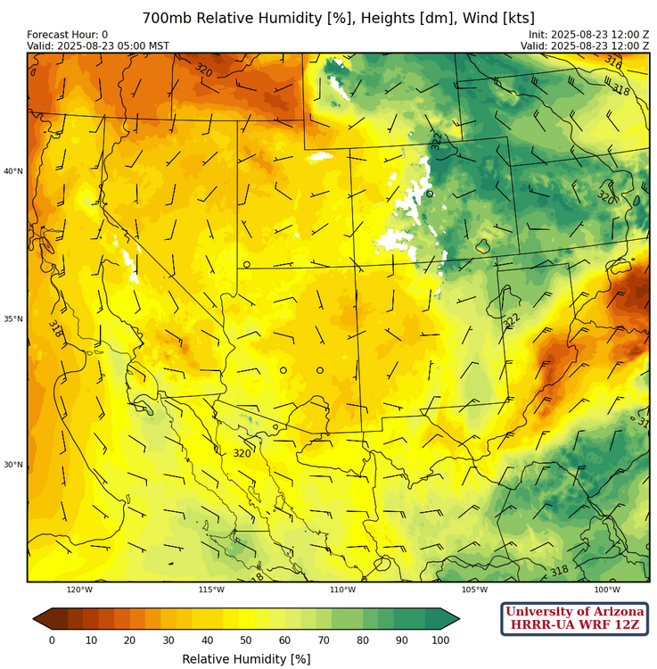
At 700mb, there has not been much change since yesterday and dewpoint temperatures at this level are around 4°C across the region. Given that the subsidence will be less today in some areas, we should see more storms especially west of Tucson.
Today
The forecast sounding for Phoenix at 4pm this afternoon shows some Convective Available Potential Energy (CAPE); likely enough for thunderstorms north of the metro area in the mountains, but probably not enough in the metro area itself. Tucson still has too much subsidence forecast to get thunderstorms today (at 500mb on the 1pm forecast sounding below, right).

Lukeville sounding has plenty of CAPE and storms will probably develop in the Sells area and move west.
The HRRR-UA WRF 12Z forecast radar reflectivity for today has storms across northern Arizona and in central and western Pima County.
Tomorrow
The location of the storms is forecast to be in about the same places as today, with an increase in intensity in northwest New Mexico. The difference is the ridge weakens, and overnight storms develop in southeast Arizona. The thunderstorms move westward across the region with some storms in Phoenix on Monday morning. Some of the storms may be aided by the surge of moisture in western Arizona.
Outlook
By Monday afternoon thunderstorms develop across northern Arizona, northern New Mexico and especially in central Pima County. Outflow boundaries from the Pima County storms will aid in late afternoon and evening storms across the low deserts. From Tucson east into Cochise County, it does not appear moisture moves into the area, but outflow from storms may increase low-level moisture anyway.

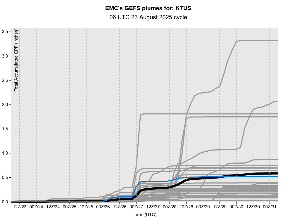
The GEFS plume forecast predicts a few days of precipitation through mid-week (26th to 28th August), but a drying off again for the following weekend. Note the scale is exaggerated by some heavy rain from a few members. But the mean precipitation of a half inch is believable, though uncertainty is high this far out into a forecast. We will probably have another round of storms next week as the monsoon winds down.
Discussion written by Pat Holbrook and Patrick Bunn