
Yesterday’s Weather
Yesterday, storms formed in the mountains mainly along the moisture axis, annotated in orange, from northern Sonora through southeast Arizona then into northern New Mexico. Strong winds aloft blew the tops off the storms eastward making it appear there was more areal coverage than there actually was. The lightning data supports this interpretation with strikes mainly on the west side of the cirrus anvils.

The HRRR-UA WRF 12Z forecast (left) captured the precipitation features well, although a little too heavy with precipitation in eastern Pinal County. 24-hour accumulated precipitation observations from MRMS are on the right.

Analysis
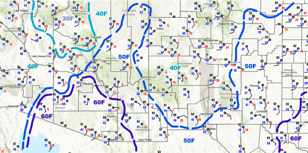
More moisture is in southern Arizona with 60°F dewpoint temperatures returning in Pima, Pinal, and Santa Cruz counties. Yesterday, storms that formed entrained the dry lower dewpoint temperature air from the lower deserts, restricting them from moving into the valleys. Today that problem does not appear to exist.
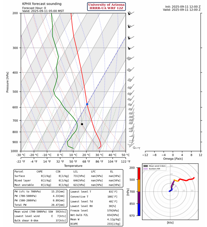
The observed sounding from Phoenix at 5am is missing today, and the Tucson sounding will not be launched until later this morning. The Guaymas, Mexico sounding is available and had a little over 2 inches of precipitable water compared to less than an inch in the HRRR-UA WRF 12Z initialization for Phoenix below. It’s difficult to understand the upper air situation in the region with this data.
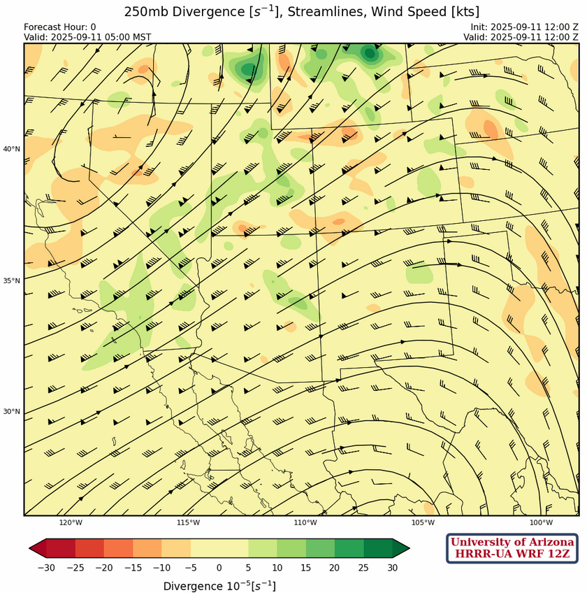
At 250mb, the low-pressure trough has moved into northwest Nevada with the high-pressure ridge remaining in west central Mexico. Southwest flow continues across the region with windspeeds around 40knots in southeast New Mexico increasing to 85knots in northwest Arizona. Maximun winds in the jet stream over southern Nevada is 105 knots.
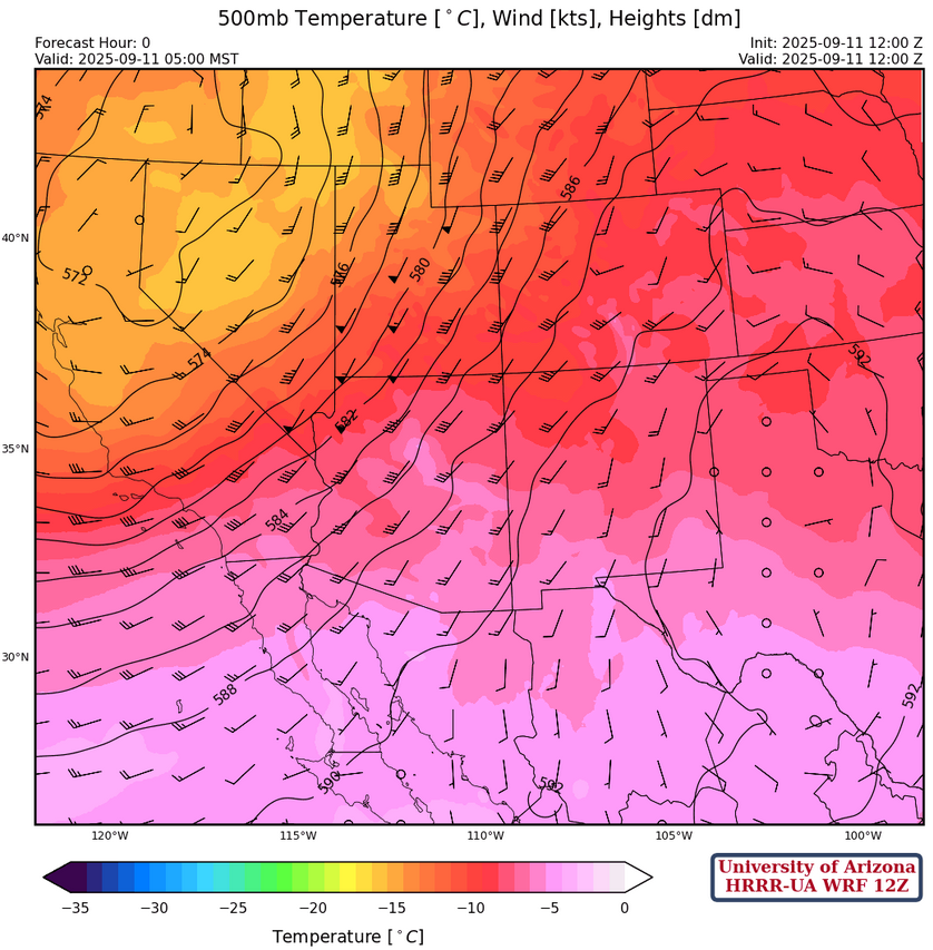
The overall wind speed has increased 5 to 10 knots in the region at 500mb, although the wind direction remains the same. The ridge and trough have moved eastward with the ridge near yesterday’s forecast position near Abilene, Texas.
At 700mb, the moisture axis may be a little farther west than shown below but overall, the model initialization looks good. Moisture increases during the day with the development of storms.
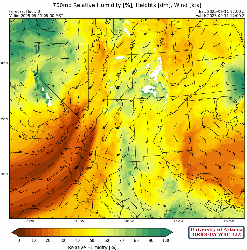
This morning’s GOES-19 visible satellite picture shows scattered clouds moving northward. Of note are the clouds along the east coast of the Gulf of California extending northward to Gila Bend, indicating moisture advecting into the area that’s not in the model forecast.

Today
The HRRR-UA WRF 12Z forecast sounding for Phoenix at 4:30pm (left) and Tucson at 3pm (right), like yesterday, show no Convective Inhibition (CIN) and plenty of Convective Available Potential Energy (CAPE) for storms to develop this afternoon and evening. The limiting factor for Phoenix is the wind direction is not favorable for the metro area but should be good for the mountains to the east and north. Tucson has a little bit of a cap (inversion) near 500mb with an extra 6mm of precipitable water compared to Phoenix. Mid-level winds are southerly meaning for storms to reach Tucson metro they need to form on terrain to our south, the Santa Rita’s, and move north.

The HRRR-UA WRF 15Z radar refelctivity forecast for this afternoon shows the storms in the Tucson metro area and staying east of Phoenix today. Tucson is forecast to get two round of thunderstorms moving north, around 5-6pm and again 8-9pm. The gusts are not too high, generally in the 30 to 40mph range.
Away from the Tucson metro area, there is a threat of heavy rain in eastern Pima County near the Rincon and Catalina mountains extending northward into eastern Pinal and western Graham counties. The high surface dewpoints in Pima and Pinal counties may indicate the storms will build farther west than the model forecasts and may result in heavier precipitation. The model forecasts the heaviest rain up to 1.75 inches on the mountains, but could be over 2+ inches if the surface moisture values remain high.

Tomorrow
Tomorrow, the moisture axis shifts east and so do the storms. Graham, Greenlee, and Cochise counties will have storms in the afternoon through to midnight with a couple inches of rain on the mountains. The rain extends east into central New Mexico.

Outlook
Except for dips in the jet stream, low-pressure systems moving through or cut off lows, Arizona is finished with the monsoon this year.
Discussion written by Pat Holbrook and Patrick Bunn