
Yesterday’s Weather
Model forecasts did a reasonable job yesterday, with storms from the Mogollon Rim to the White Mountains and even showed less activity in Graham and Cochise Counties.

The storms in Pima and Santa Cruz Counties did not have much vertical depth thanks to the strong mid-level easterly winds and convergence aloft. Overnight low-level moisture pushed back into the state.
Analysis
Joining the situation today is another tropical upper tropospheric trough (TUTT) which is off the spur of the Baja. The TUTT in the Gulf of Mexico is in about the same location in the northwest of the Gulf. The TUTT in the Atlantic has weakened and moved northward with a shear zone extending southward into the central Caribbean Sea then to the TUTT in the Gulf of Mexico, and then to the new TUTT off the Baja coast (shown by the TUTT axis below).

At 250mb, anticyclones are in Georgia and in Mexico southwest of the Big Bend, and well off the west coast of the United States. A shear axis extends northward from the low across southern Arizona and is moving slowly west along with the low. This will put southeast Arizona in divergent flow this afternoon (shown by green contours below).
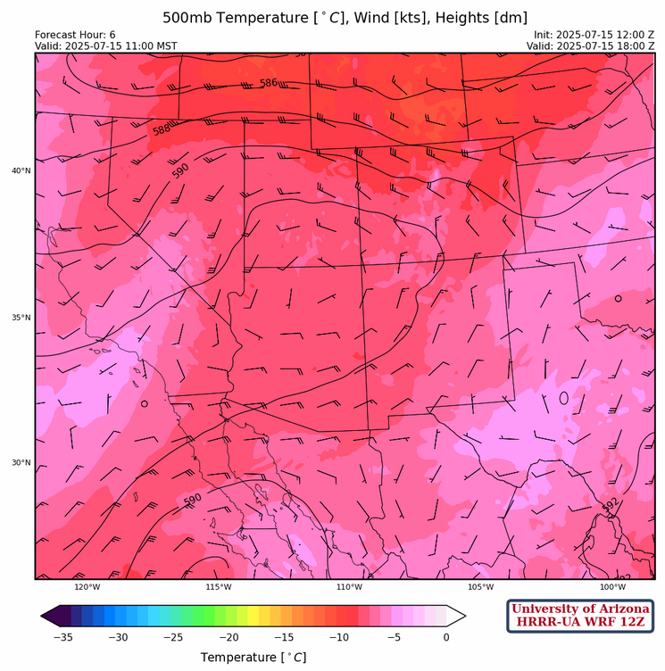
The upper low at 500mb is off the west coast of Baja and flow around the low is from the northeast at 25 knots. A ridge axis is from southern California to northern Arizona then east to Oklahoma. The winds should weaken during the day as the low moves further west.
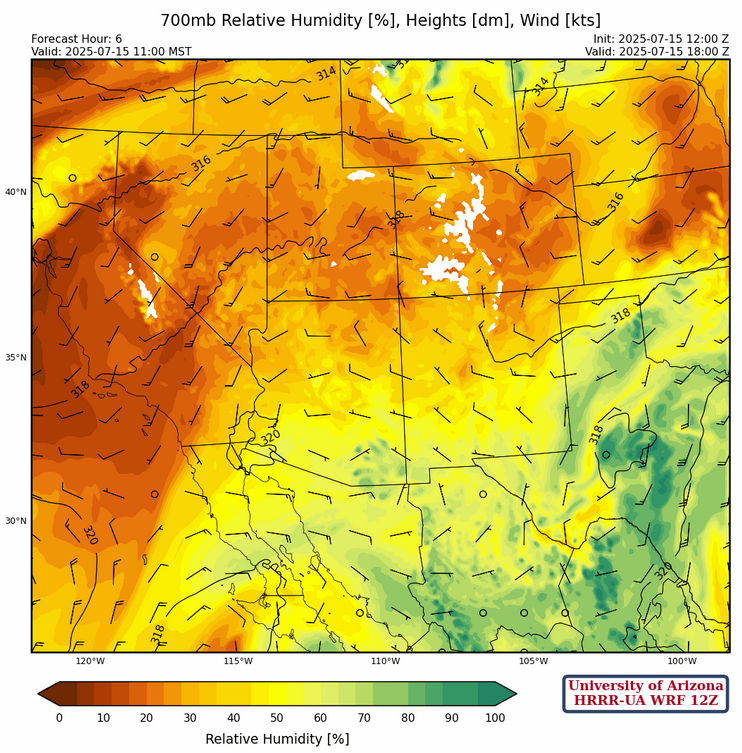
At 700mb, winds are generally light from the west across the region with an axis of higher relative humidity values running from the Sierra Madre mountains in Mexico northward to southeastern Arizona. The ridge is over Big Bend and there’s low pressure southwest of the spur of Baja.
Today
The model forecast soundings below are for 5am and 2:30 pm at Tuscon. The mid-level winds weakening, combined with divergence aloft, and typical daytime heating means thunderstorms will fire on the mountains and move westward.

The HRRR-UA WRF runs for 12Z yesterday (left) and today (right) valid for this afternoon are consistent with the storms in southeast Arizona as well as the White Mountains and Mogollon rim.

Oddly enough Tucson airport has 1.2 inches of rain in the HRRR-UA WRF 12Z run and 0.3 inches in the latest HRRR-UA WRF 15Z. The best thing to say is that somewhere in the city both totals will happen.

The 250mb divergence forecast this afternoon is also favorable for deep convection as flow is over-the-top of the ridge axis.

Overnight tonight some of the storms push up into Phoenix with the GFS (right side below) more generous than the HRRR (left side below).
Those concerned about a dust storm/haboob; today should be the best day for it.

Tomorrow
It looks threatening, but the valleys should be pretty worked over by today’s storms. Except for storms on the mountains of the Mogollon Rim, and southwest of Tucson, they should be quickly shut down due to the lack of CAPE in the valleys. Maybe there will be enough rain to help put out the fires in the Grand Canyon.

Outlook
Mid-level flow will be from the southeast, and this is not favorable for organized convection until Friday. Only isolated mountain storms are expected on Thursday. GEFS plumes are equally split between no significant precipitation for the next week, versus a low-grade monsoon bringing less than an inch.

Discussion written by Pat Holbrook and Patrick Bunn