
Live weather forecast briefing
The recording of the live weather forecast briefing is available here.
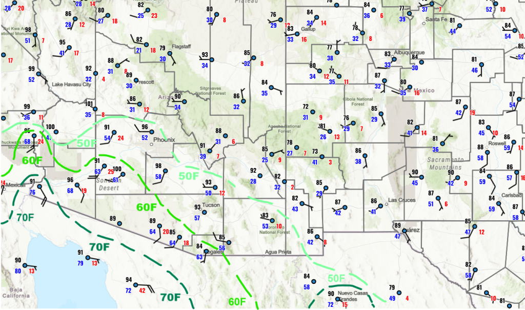
Yesterday’s Weather
Poor Ivo; it reached tropical storm status, but was overshadowed by two Mesoscale Convective Systems (MCSs) moving northwest up the east side of the Gulf of California. The northern MCS appears to be associated with the northern push of surge moisture. Wind gusts from the thunderstorms were over 40 mph. Both MCS’s are supported by strong upper-level divergence. The storms on the Baja peninsula itself also point to a surge at this location, as the storms would not exist without deep moisture.
Dewpoint temperatures along the international border increased last night and this moisture may not mix out and could be reinforced by surge moisture, so this should be a prime location for thunderstorms today.
Analysis
Surface dewpoint temperatures in Tucson increased from midnight in the high 40s, well into the 60s around sunrise. Now mixing has started, due to solar heating of the Earth’s surface, the surface dewpoint temperature is now 57°F.
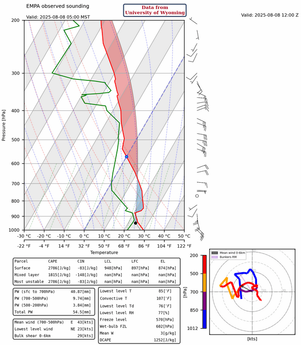
Spot the surge in moisture in the observations taken on UofA campus below.

The Empalme (Guaymas), Mexico, sounding shows the gulf surge below 850mb. A moist boundary layer profile, 25kts near surface winds from the south/southeast, and almost 2 inches (54mm) of precipitable water.
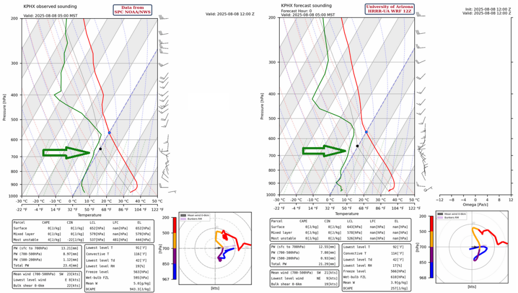
Soundings for Phoenix also shows the beginning of the surge below 900mb. The HRRR-UA WRF 12Z initialization for Phoenix (below right) does show the surge, but it is light on water vapor between 900 and 600mb compared to the observed sounding (below left). The result is that precipitable water from the observed sounding is about an inch while the model is 0.1″ less. Still, the 900-600mb profile is drier in the forecast, and just a small difference can make all the difference.
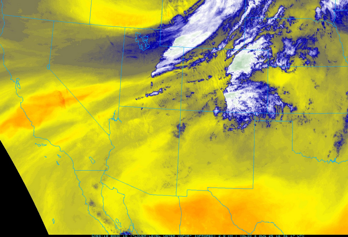
The low-level water vapor satellite image this morning shows a synoptic scale trough in Idaho. This is drawing the surge moisture northward.
The high pressure ridge at 250mb over New Mexico has moved east into west Texas. The model forecasts are having difficulty resolving the anticyclone associated with Ivo with it being too far north of the model position. The trough in Idaho and the circulation around the high in Texas has resulted in westerly winds over the region, 30 knot wind speeds in the north dropping to less than 10 knots in the south.
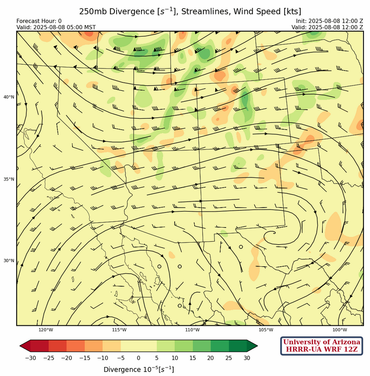
At 500 mb, the ridge axis extends west to east from north of Yuma to the White Mountains then across central New Mexico with eaaterly winds across southern Arizona and westerlies to the north.
The ridge at 700mb is in two locations this morning with a center over Yuma and another center further east over north Texas. A ridge axis is between the two centers. Westerly winds are north of the ridge axis with easterly flow underneath the ridge axis, except in southeast Arizona where the wind flow is from the north.
Today
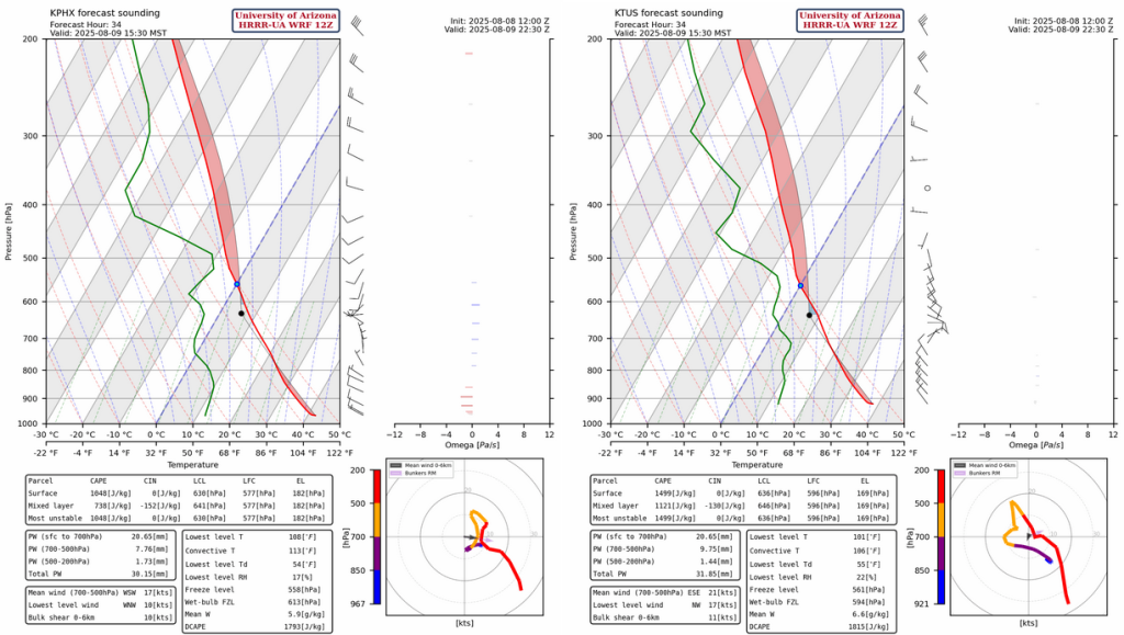
The HRRR-UA WRF 12Z forecast soundings for Nogales at 4pm and Tucson at 2pm is shown below. Mixed layer convective available potential energy (CAPE) is over 1000 [J/kg] at Nogales (left) and 600 [J/kg] at Tucson (right). Both soundings would support storms, but will the storms move into the valley in Tucson?

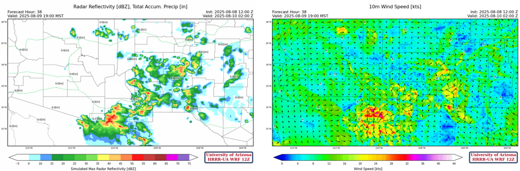
The forecast radar reflectivity loop keeps the storms south of Tucson metro area as the dewpoint temperature drops to 51°F. The net effect of the upslope afternoon winds is a big negative for thunderstorm formation in the valleys.
Overnight, more surge moisture moves into Arizona again, as shown in the dewpoint temperature forecast below. Some showers and thunderstorms form at night and move from the Tucson area northwest toward Phoenix by morning.
Tomorrow
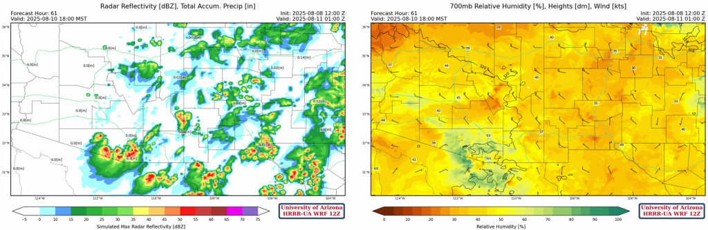
The overnight convection may spoil the potential for storms in Phoenix and Tucson tomorrow, due to a cooler temperuatures in the boundary layer. The HRRR-UA WRF 12Z forecast soundings for Phoenix (left) and Tucson (right) are shown below.
Cooler temperuatures in the boundary layer does not affect the entire area, as storms form further east with heavy rain and strong wind gusts in
Outlook
The trough to the north creates a northwest wind flow with thunderstorms developing over the eastern half of Arizona and most of New Mexico. Motion will be from the northwest.
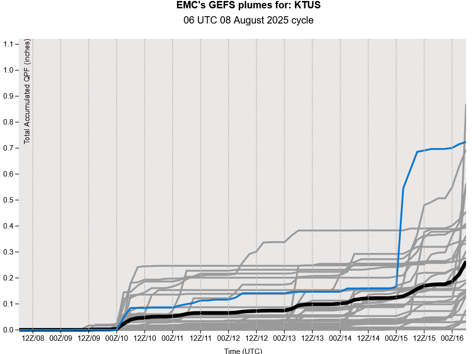
As for the GEFS plume forecast, it dry’s out after this weekend’s storms until next weekend.
Discussion written by Pat Holbrook and Patrick Bunn