
Yesterday’s Weather
The reference to Groundhog Day was because yesterday was essentially a repeat of Saturday with a few exceptions. In Arizona the winds were lighter and temperatures lower than Friday. Strong thunderstorms in eastern New Mexico (see satellite picture below) moved off the mountains producing hail and heavy rain in spots. The monsoon axis was pushed eastward in response to the large trough over the intermountain region to the north. The state of Arizona remained high and dry. The moisture push northward from the Gulf of California slowed, but this is rather typical during the day and should resume overnight.
Analysis
At 250mb, the trough remains around the same location as yesterday, with strong southeasterly winds. There is also high pressure in Texas, but only at 250mb. The tropical upper tropospheric trough (TUTT) low has traveled farther west, but is still over the Gulf south of Louisiana.

At 500mb, temperatures have cooled down, and a low has formed over central California. Effectively the portion the original trough moved northeast, but the trough axis remains in about the same location. For summer, the –8C temperature at Phoenix would easily start storms but we are still lacking moisture.

At 700mb, the winds over Arizona are strong and southerly with weaker winds over New Mexico. The moisture axis has traveled further to the east, centering around Lubbock, TX. Low pressure over California at 700mb is stacked with the low at 500mb.
Phoenix sounding still has no CAPE, but at least some moisture to the south is moving into the region. As forecast by the models, moisture is pushing into southeast Arizona along the Colorado River with surface dew point temperatures now rising into the mid 60s. Surface dew point temperatures have also increased into the mid 50s in southern and southeast Arizona along with mid-level clouds across Cochise County.

In New Mexico, surface dew point temperatures are in the mid 50s to low 60s, and moisture there is rather deep with 15C dew points at 850mb and at 700mb it is a whopping 8C. These type of moisture values required the issuance of a flash flood watch across eastern New Mexico and west Texas.
Today
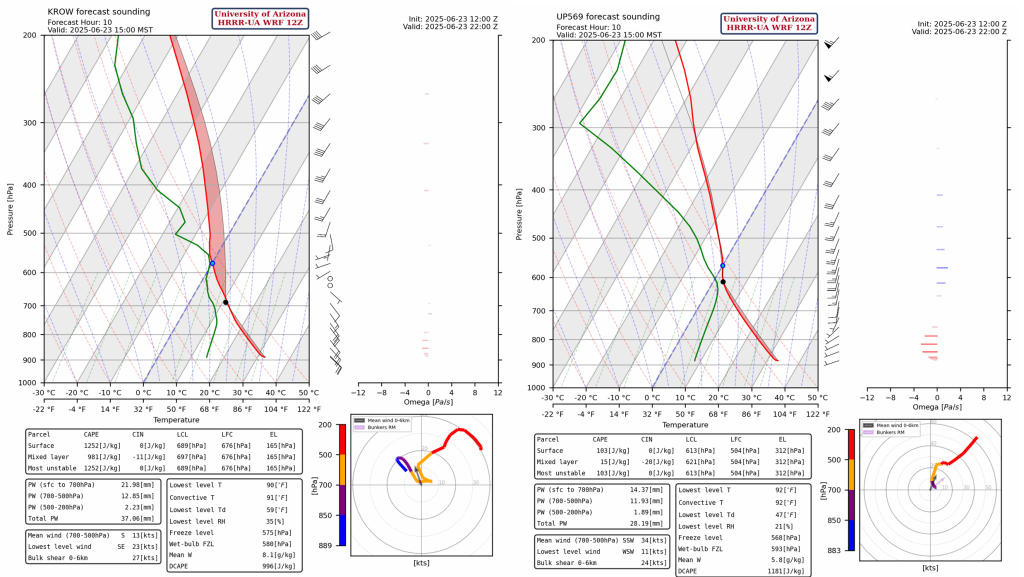
The surface moisture in Arizona that was moving in from the south will mix out, and only southeast Arizona will have enough moisture for storms this afternoon. The Roswell forecast sounding at 3pm below shows plenty of surface-based CAPE. The sounding for San Simon doesn’t have any CAPE, but convection will only initiate at high elevations east of San Simon in Cochise County.
The result of this moisture is shown below in the simulated radar reflectivity (left) and total accumulated precipitation (right).
The CAPE forecast below (left) shows most of the convection in eastern Arizona will be rather weak, and stronger storms with the higher CAPE values in New Mexico. The 10m wind speed forecast (below, right) shows potential for microbursts associated with some thunderstorms over New Mexico.
Tomorrow
Forecasts indicate the monsoon moisture axis shifting further west into Arizona. The HRRR-UA WRF 12Z shows some nocturnal storms forming in western Cochise and eastern Pima counties in the early morning hours and moving northward into eastern Arizona.
Not much actual rain reaches the ground with these storms as shown below precipitation accumulation out to midnight tomorrow evening. But these storms should produce lightning in these areas for the first time.

Outlook
In general, comparing the HRRR-UA WRF and GFS-UA WRF forecasts for later in the week, thunderstorms are traveling further west into Arizona for HRRR-UA WRF, but both models agree on high precipitation accumulation in the region of Roswell, NM. Most of the rain in southeast Arizona is expected on Tuesday and Wednesday, but note how the lower desert to the west is still dry. Moisture with the monsoon flow is mainly mid-level moisture and mixing during the day will not allow the storms across the desert regions.

These forecasts are a little too far out for us to have any confidence in them, so be sure to check back in over the next two days to see how the forecast situation will develop.
Discussion written by Pat Holbrook