
Yesterday’s Weather
New Mexico was mostly suppressed in terms of convection except for the far southeast, but storms were much weaker than previous days. In Arizona, storms extended from northwest Arizona (producing heavy rain and flooding in Yavapai County) southeast to the Mogollon rim and then to the White mountains. Thunderstorms did not move very far off the mountains as the easterly surface wind suppressed the storms over the valleys. Storms did develop in central and western Pima County in a deeper moisture axis and moved westward. As the evening progressed, storms developed in Pinal County as elevated CAPE was not affected by the boundary layer. These storms produced very little rain.
Analysis
At 250mb, the trough off the coast of California has advanced further onshore. Strong southerly winds associated with this trough have made their way into Arizona and New Mexico is experiencing strong westerlies.

A tropical upper tropospheric trough (TUTT) has moved back to the east off the coast of Florida and Georgia. The TUTT mentioned in yesterday’s discussion, south of the Yucatan Peninsula, has disappeared. However, another TUTT has now formed further to the east out in the Atlantic.

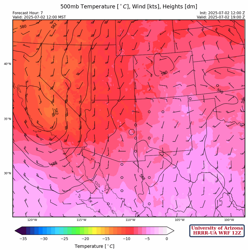
At 500mb, the cutoff low has advanced slightly further into California. Light and variable winds are over Arizona and southerly winds are over New Mexico. Temperatures in Arizona have not changed and are still cooler than normal.
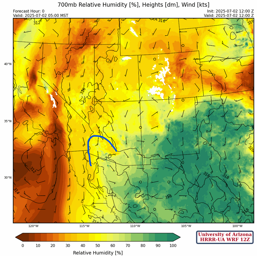
At 700mb a tongue of moisture, annotated in blue below, extends up the Gulf of California and into Arizona. This axis of moisture is where mid-level based showers and thunderstorms have formed overnight.
Today
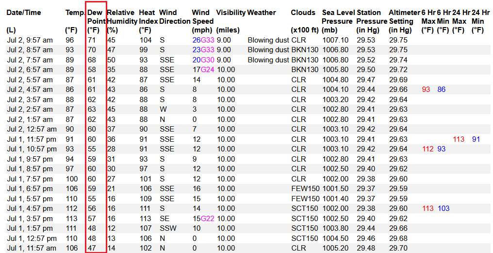
Today brings flooding risks to Arizona. Southerly winds, the dynamic lifting ahead of the upper-level trough in California, and moisture from the gulf surge in combination bring thunderstorms to the mountains in the western half of the state. Here’s the most recent observations from Yuma showing evidence of the gulf surge; the dewpoint temperautres increase from high 40s at noon yeserday to the low 70s this morning.
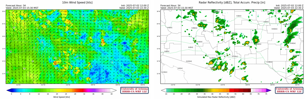
Some of these storms may travel off of the mountains and into the valleys. The dynamic lifting from the upper-level trough could cause storms to train over the mountains along the Mogollon Rim, where new storms form upstream of previous ones, causing many storms to potentially hit the same location over and over. Mircrobursts are also expected with many of the storms, with strong winds traveling towards Phoenix potentially casuing blowing dust if it arrives before the rain. Southeastern New Mexico is also expected to receive rain today starting in the afternoon and into the evening, mostly staying over the mountains. Some storms could move into the valleys and produce flooding. Similarly to yesterday, we’re favoring the HRRR-UA WRF from 12Z forecast below on the left, as it seems to handle the movement of thunderstorms off the terrain and to the west better. Rainfall will likely arrive in the early afternoon for Tucson and mid to late afternoon in Phoneix.
Accumulated precipitation totals from the most recent four HRRR-UA WRF are shown below. For Phoenix metro totals range from 0.1 to 0.7 inches and totals for Tucson metro could be from 0.2 in to 1.3 inch.

Tomorrow
By Thursday, isolated thunderstorms form over the mountains with better coverage in Northern Arizona and eastern New Mexico. The monsoon circulation has shifted south of the region. Only a few microbursts will be associated with storms.
Outlook
As the trough swings by to the north, mid- and upper-level temperatures will warm. At 500mb today it’s –8C then warms to –5C by Friday. Model forecasts also show 700mb drying at the same time. There should be enough low-level moisture for thunderstorms over the mountains, but few will make it into the valleys. The GEFS plumes for Tucson and Albuquerque in the images below indicate the dry trend will continue through the early part of next week.


Discussion written by Pat Holbrook