
Yesterday’s Weather
The satellite picture below shows the extent of the thunderstorms from yesterday. The anvils were quite extensive.
The HRRR-UA WRF 15Z from yesterday was the best forecast of the UA WRF ensemble members as it predicted warming in a layer between 400 and 500mb that would limit deep convection. The tops of the storms blew to the north making most locations in Tucson only receive anvil rain.

Some of the mountains did get over an inch of rain, but Tucson valley precipitation was closer to a quarter of an inch.
Analysis
This morning a few mid-level based showers, and a thunderstorm or two, are in the mountains east of Phoenix and in western New Mexico. The clouds have decreased since yesterday covering eastern Arizona and western New Mexico. Southeast Arizona only had a few clouds that have burned off after sunrise and now there’s just a few on the mountaintops as convection is already starting. This is a much better cloud field than yesterday and will allow for more surface heating and stronger convection.
The tropical upper tropospheric trough (TUTT) to our south is stationary south of the Baja Peninsula, while the TUTT in Texas is centered east of Midland. The TUTT in the Atlantic, has moved west and is near the Barbados islands.

At 250mb, a trough has dropped into the Pacific northwest resulting in southerly winds at 40 to 50 knots over western Arizona decreasing to 10 to 20 knots of Western New Mexico. The circulation from the TUTT centered in Texas is over eastern New Mexico and covers the eastern part of the state with northerly winds.

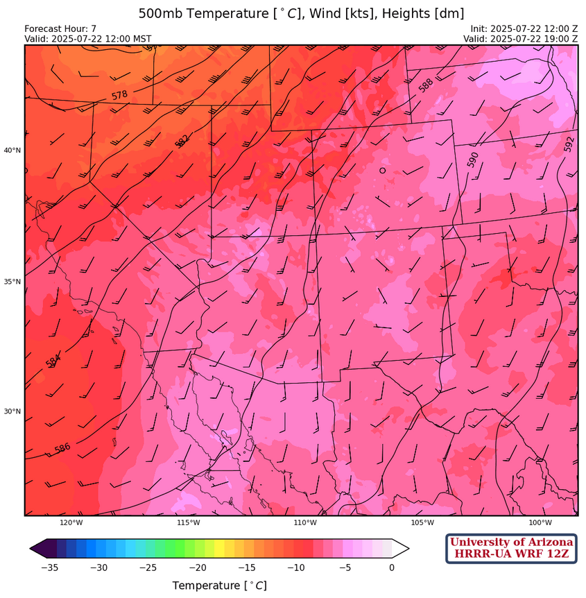
At 500mb, southerly winds are across both states with the warmest air in northwest Arizona. In southeast Arizona temperatures cooling which is again favorable for deep convection. The trough in the Pacific northwest is in Oregon and Washington.
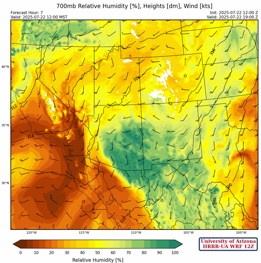
At 700mb we still have a fair amount of moisture today across most of Arizona and New Mexico, the dry air moving in from California will begin to limit convection tomorrow.
Today
Storms will form on the mountains of southeast Arizona, the eastern part of the Mogollon Rim, the White Mountains, and most of New Mexico. The heaviest precipitation in Arizona will be in and near the mountains with only light amounts in the valley.
Central and northern New Mexico will be affected by the TUTT centered in Texas with strong divergence aloft and storms moving into the valleys. Localized heavy rain in Albuquerque and Santa Fe is possible (0.5-1″), and also in the eastern third of New Mexico. The precipitation axis is also a little further to the northeast compared to yesterday, away from where the international border is. South into Mexico is void of storms, which is a reflection of the dry air moving into the state from the west.
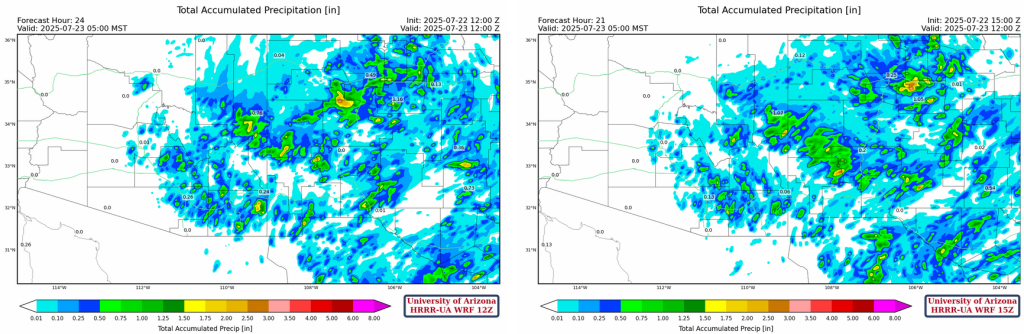
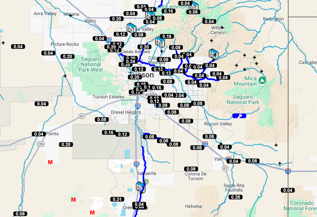
Precipitation totals from the most recent HRRR-UA WRF forecasts show Tucson airport getting about 0.1-0.2″, so we expect these type of totals for the Tucson metro area. Whether there will be a direct hit on the airport or not is sheer luck (or unlucky depending on your current Monsoon Fantasy score).
Tomorrow
Storms shift even further north and east as the incoming dry air results in 30°F dewpoint temperatures in the deserts of Arizona. Storms that form in New Mexico will be mostly near mountains with less coverage than today.

Outlook
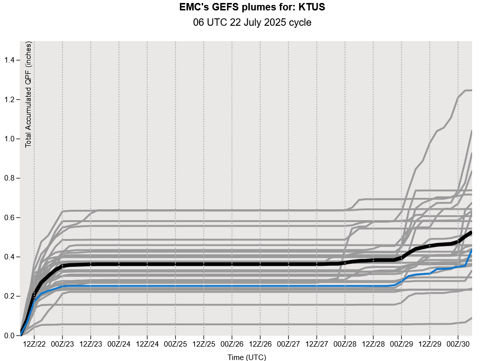
Only New Mexico has precipitation on Thursday as the monsoon circulation has been cut off by the dry air moving in from the west coast. The GEFS plume forecasts show that we are out of the “monsoon business” until next week, with temperatures heading to above normal. The good news is that both the long-range forecasts from GFS and ECMWF show the moisture coming back into the region next week.
Discussion written by Pat Holbrook and Patrick Bunn