
Yesterday’s Weather
Yesterday’s observed composite radar reflectivity from MRMS (below, right) shows the bulk of the storms were in the mountains. The thunderstorms did not move into the valleys where it either rained recently (Phoenix), or surface heating was limited by cloud cover yesterday (Tucson). The southern half of Cochise County had light rain most of the day as did southwest New Mexico. Overnight, thunderstorms in southern Nevada moved into northwest Arizona this morning with locally heavy rain.
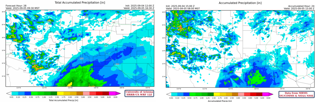
Shown below are the 24-hour accumulated precipitation forecast from yesterday’s HRRR-UA WRF 12Z (left) and observations from MRMS (right). The forecast rainfall totals associated with the tropical storm may be a tad high, but Bisbee received 0.60 inches and Janos, Chihuahua had 0.75 inches. The precipitation was from the sheared tops of Lorena and the rain falls at a low rate over a long period of time usually not leading to flash flooding. Also, the Doppler Radar at the Tucson site has significant beam blockage to the southeast and therefore it can only see the tops of the storms in that area. Yuma had a severe thunderstorm with nearly an inch of rain, that wasn’t in the forecast. Perhaps the activity in western Pima County that was forecast was miss-placed.
Analysis
A lot of moisture remains in Arizona from Lenora and a trough passing by to the north. Although southern New Mexico moisture has increased, the eastern and northern half of the state remains similar to yesterday.

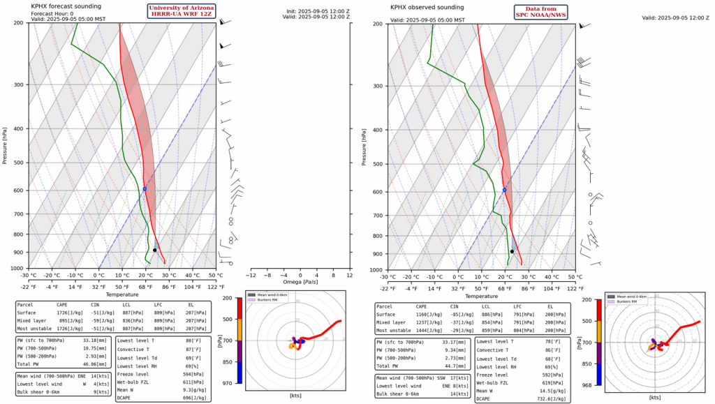
Both the observed sounding and forecast initialization for Phoenix this morning at 5am captured the increase in precipitable water and the northerly wind flow near 500mb. The forecast daily maximum temperature should reach the 86°F convective temperature, as temperatures are already in the low 80s at 9am. The soundings represent an unstable atmosphere that just needs a little heat or outflow vertical push to initiate thunderstorms.
The GOES-19 visible satellite at 9 am this morning shows the thunderstorms still moving southeast from west of Flagstaff to Prescott, then to near Blythe, California. The storms continue to move southeast and should assist in the development of storms in the Phoenix metro area this afternoon. Most of the middle and high clouds from Lenora have moved into New Mexico.

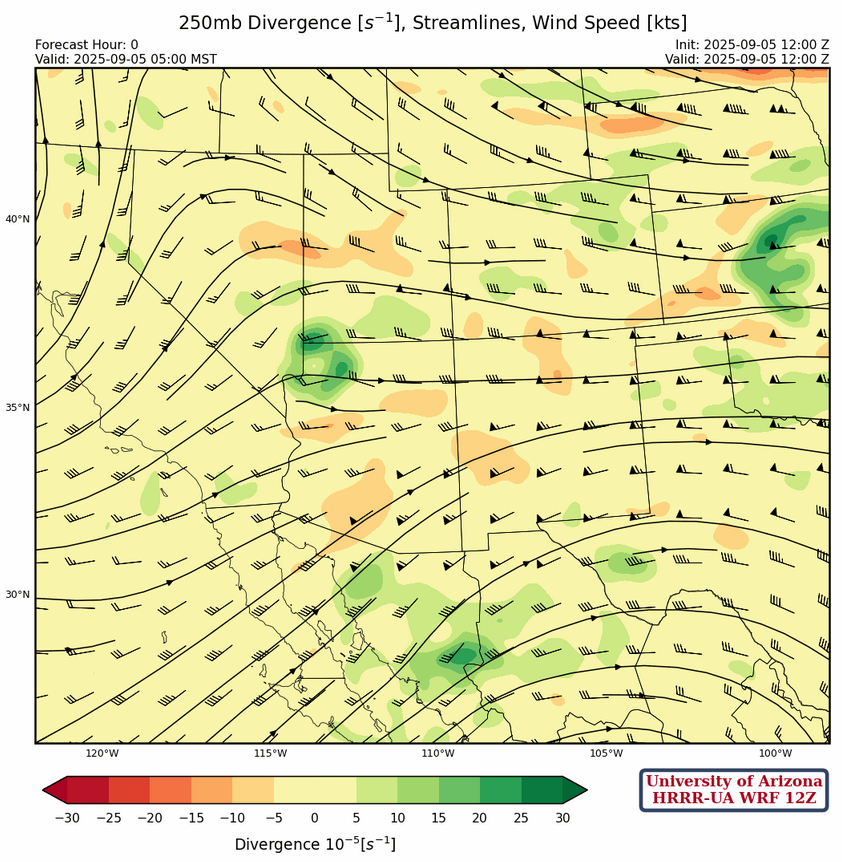
At 250mb, the region is caught between the trough off the west coast of California and the high pressure ridge in central Mexico. This pattern does not change much over the next few days although the 50+ knot winds over the southern part of the region shift north to northern Arizona and New Mexico over the weekend.
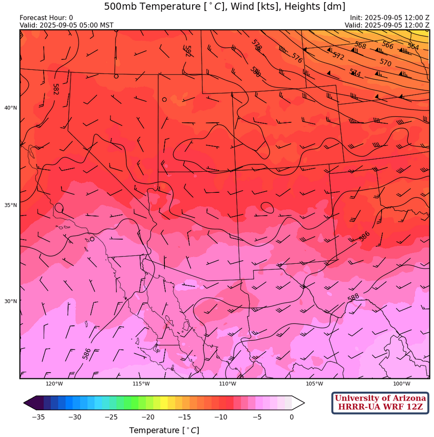
The flow at 500mb is becoming more northerly today, backing to westerly tomorrow. The temperatures aloft are still cold, about -9°C, and will warm over the next few days.
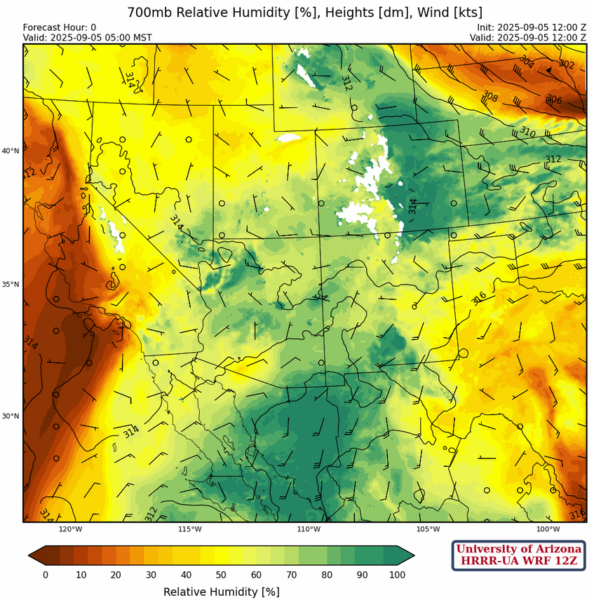
There is still plenty of moisture across the state at 700mb with dewpoint temperatures at or above 4°C. With weak wind flow today, moisture will remain in the region and slowly decrease beginning Sunday.
Today
The forecast sounding for Phoenix at 1pm (below, left) is more unstable than the forecast sounding for Tucson at 2pm (below, right).

Storms in western Arizona continue to advance east and they have not been captured well by forecast models. These storms should move into the Phoenix metro area in the early afternoon. Showers are already forming over the mountains around Tucson and there does not seem much limiting the storms moving into the valleys during the afternoon and evening. The only issue is the shear from the mid-level to upper-level (Lorena outflow), which could be too strong for deep convection and cut the updrafts off.
The HRRR-UA WRF 15Z forecast shows the storms approaching Phoenix, but the forecast has them disspate and move north east of Phoenix. The storms are stronger in the observed radar than the forecast and since it will only be a couple of hours before it reaches Phoenix not much weakening is expected despite the forecast. Tucson is still iffy as storms should form on the mountains and could drift into the valleys.
Tomorrow
One last day for this monsoon season with an increase in storms over southeast Arizona and New Mexico, though they will be scattered. Dry air will then move into western Arizona.

Outlook
Models have consistently forecast a major drop off in storms on Sunday as the westerlies bring in dry air (and warm air aloft) across the region. Only a few storms near the mountains are expected.

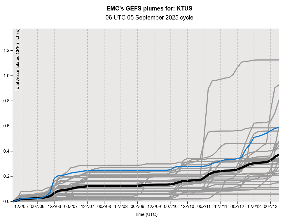
The GEFS plume forecast shows some storms are possible next weekend, though they are a result of a trough in the westerlies. Though this system taps monsoon moisture, dynamically speaking they’re not monsoon thunderstorms.
Discussion written by Pat Holbrook and Patrick Bunn