
Yesterday’s Weather
The forecast panned out fairly well as the axis of moisture was orientated from southwest to northeast across New Mexico. Most of the storms were on and near the mountains. Development of storms in Cochise County did not happen because of the strong upslope dry winds from the low desert areas. The combination of the hot temperatures and strong winds made it seem like a blast furnace.
To the south in Mexico there was an impressive blow up of storms along the spine of the Sierra Madre mountains. The moisture was probably from former hurricane Erick combined with divergence from the anticyclone over that part of Mexico. Models underestimated the CAPE associated with the storms.
Outflow from last night’s thunderstorms has been pulled northwards by the upper level trough and has brought moisture into eastern Arizona and New Mexico. But as the low-level water vapor satellite imagery shows it is still very dry to the west (red colors).
Analysis
At 250mb, the trough has moved further into our region, strong westerly winds aloft with more of a southerly component than the previous days. The anticyclone associated with former hurricane Erick moved further into northern Mexico last night, which was responsible for some thunderstorms in that region. There is divergence associated with the upper level trough to the north, but not much around here.

At 500mb, there is a stronger southerly component to the winds than at 250mb, temperatures aloft still remain very warm.

At 700mb, the moisture axis has shifted slightly further to the east in New Mexico, bringing storm chances into the region over the mountains. Arizona remains dry and warm. The green colors show high relative humidity values where monsoon moisture is coming up from Mexico into New Mexico today, with a strong moisture gradient dividing Arizona/Sonora and New Mexico/Chihuahua.
Today
Overall, a very similar pattern from the past few days. Thunderstorms are expected in New Mexico over the mountains, more to the east than previous days.
The forecasting sounding for Roswell, New Mexico shows strong CAPE and weak CIN from a mixed layer parcel, showing a strong thunderstorm potential. These thunderstorms may also travel into the valleys. Temperatures will once again cool off in Arizona, with around a 5 degree F drop.

Strong winds will blow across the state this afternoon, sustained winds will be around 20mph with gusts of up to 40mph in eastern New Mexico and the northern half of Arizona. Due to the winds and dry weather, there is a red flag warning currently in effect for the north half of Arizona and northwest New Mexico.
Tomorrow
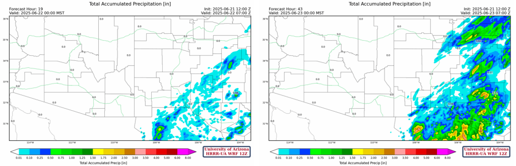
More widespread thunderstorms are expected in eastern New Mexico. Total accumlated precipitation to midnight tonight versus midnight tomorrow night shows the uptick in rainfall for New Mexico.
Temperatures will slightly drop, less than 5 degrees F, again for both Arizona and New Mexico. The winds will also be weaker tomorrow. The upper-level trough will remain in roughly the same position.
Outlook
The upper-level trough will remain around the same location for the next few days. New Mexico will recieve quite a bit of rain over this period. As for the Arizona monsoon, the GFS has been more aggressive with moisture values, but has been backing off with the past few model runs. Due to this, we are siding with the more conservative HRRR and ECMWF models, which predict a slight potential for light rainfall next week.
Discussion written by Pat Holbrook