
Yesterday’s Weather
A Mesoscale Convective Complex (MCC) developed in northern Sonora yesterday afternoon with other storms in the White mountains and western New Mexico.
By 11pm the MCC collapsed, and a strong outflow/gravity wave pushed into Arizona. The wave reached Tucson by midnight, Phoenix by 2:30am, and moved into California in the early morning hours. If any convective available potential energy (CAPE) was available in the boundary layer, the relatively cool air in the wave gave the vertical push needed for thunderstorms to develop in its wake and caused light showers.
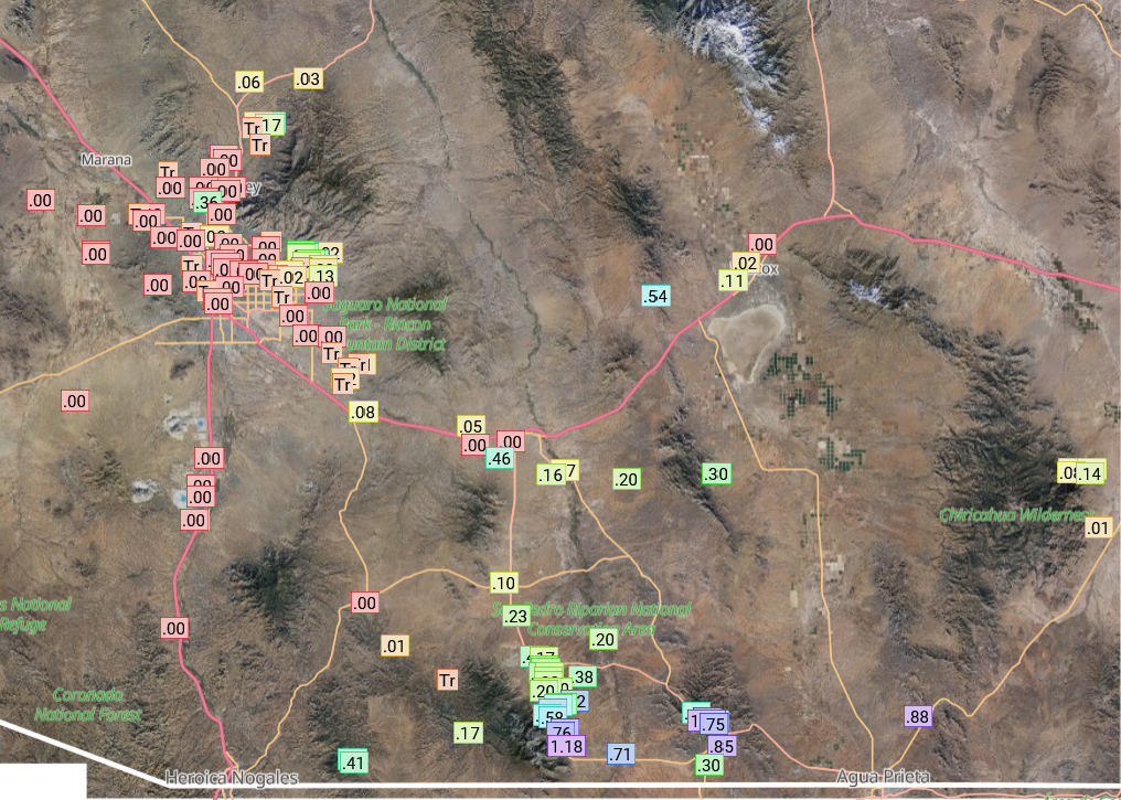
The precipitation totals were generally light as shown by gauge data from Pima County Regional Flood control and Rainlog.org, but extended from the Arizona border northwest to Tucson and Phoenix (where a few drops fell at the airport, trace recorded).

Some locations in southwest Cochise County had over an inch of rain.
Analysis
The outflow from the MCC increased the surface moisture up to Flagstaff and along the Colorado River, but decreased moisture in southeast Arizona. This reflects the mixing in the boundary layer, though total moisture in the boundary layer has not changed.

Tropical upper tropospheric troughs (TUTT) are marked on the upper level water vapor satellite image from this morning shown below. Compared to yesterday a new TUTT low west of Haiti. Tropical storm Ivo is still moving west away from Mexico.

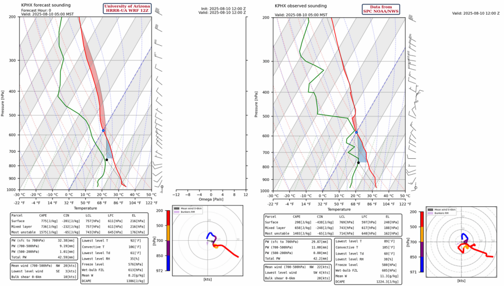
Upper air soundings for Phoenix, forecast initialization (below, left) and observed (below, right), have over 1.6″ (42mm) of precipitable water this morning with moisture assistance from the outflow from the MCC; that’s the positive. On the negative side, is over -200 [J/kg] of convective inhibition (CIN) and the forecast storm motion is from the northwest. Storms will form on the Mogollon Rim, but we will need some strong outflows to get them into Phoenix metro area.
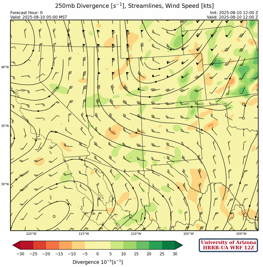
At 250mb, a strong trough extends from Wyoming into northern Arizona. Other features at 250mb include a ridge off the Oregon coast, a low off the coast west of Los Angeles, and a ridge west of the spur of the Baja. The flow over the region is from the west to northwest at 20 to 30 knots. Winds weaken and turn northerly over Mexico between the ridge and the Texas TUTT low.
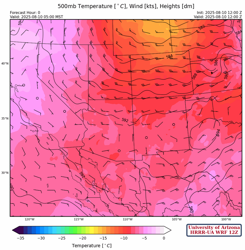
West winds of 15 to 25 knots are at 500mb over northern Arizona/New Mexico between the ridge axis in the central part of the two states and the trough over Wyoming. Light mostly easterly winds are in southern Arizona and New Mexico.
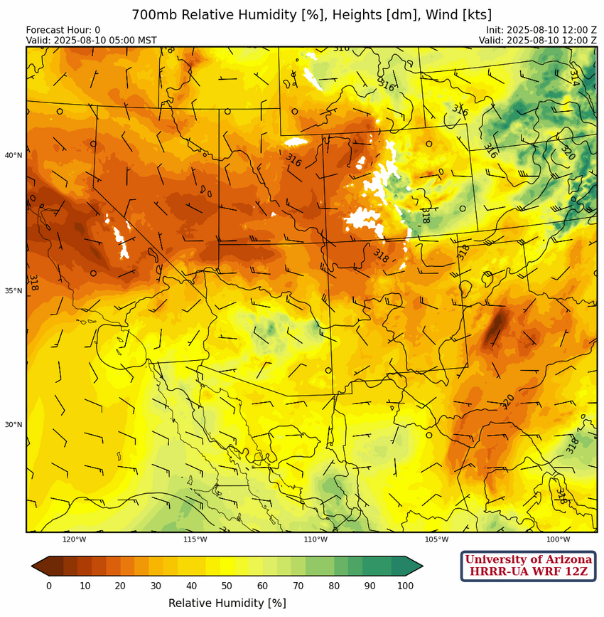
Increased moisture content can be seen across the southern half of Arizona at 700mb. Flow is from the west to northwest across central and northern part of the region turning northerly in southern Arizona.
Today
The HRRR-UA WRF 12Z forecast sounding for Phoenix at 4pm (left) and Tucson at 7pm (right) is shown below. Both soundings are at the time of lowest CIN. Thermal wind at Phoenix is from the west at 5 knots while Tucson its almost zero. Either profile would be more susceptible to outflows and merging outflows initiating storms. The weak flow increases the potential for heavy rain.

The radar reflectivity forecast shows the convective initiation starting in the early afternoon on the Mogollon rim and other terrain features with thunderstorms blowing to the southeast. Back building of storm against this southeast flow is forecast to have storms entering the Tucson metro area at but the evening about 8pm.
HRRR-UA WRF 12Z forecast 10-meter wind speed is below and the strong winds near Phoenix may initiate thunderstorms in the metro area, while the winds to the south of Tucson move north into Tucson about an hour later, causing the back building of storms seen in the radar forecast.
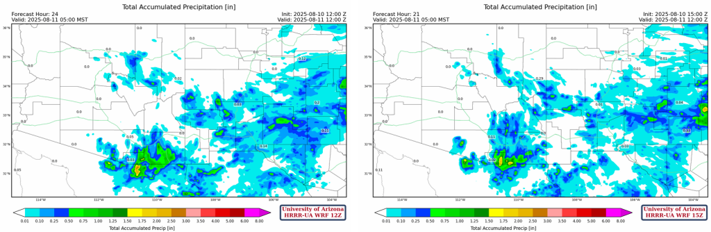
24-hour accumulated precipitation totals are shown from the two most recent HRRR-UA WRF forecasts. 0.5″-1.0″ in parts of Santa Cruz and Cochise county, but a lighter amounts in the Tucson valley; 0.05-0.1″ forecast for the Tucson airport.
Tomorrow
Tomorrow forecast soundings for Phoenix show too much CIN to support thunderstorms. As for Tucson, both afternoon and evening will have thunderstorms close by as shown in the radar forecast below. This represents a decrease in precipitation from today’s forecast.

Outlook
On Tuesday, another ramp up in thunderstorms is forecast from the White Mountains to Tucson, and east into New Mexico. Heavy rain, blowing dust, and strong gusty winds will be associated with the storms.

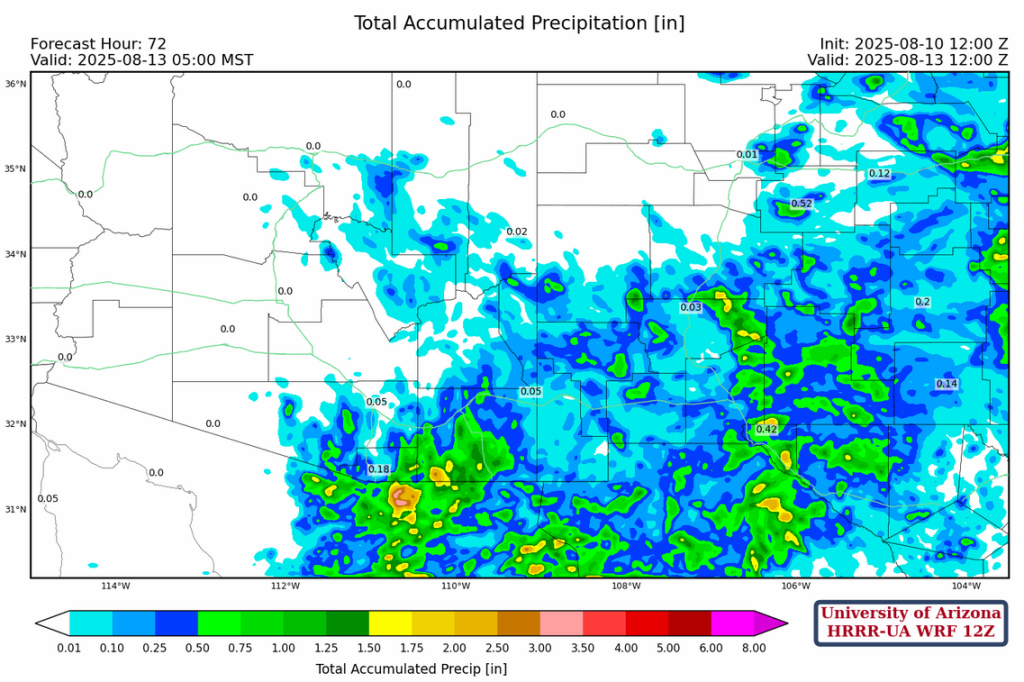
Total precipitation through Wednesday morning at 5am. Something is better than nothing!
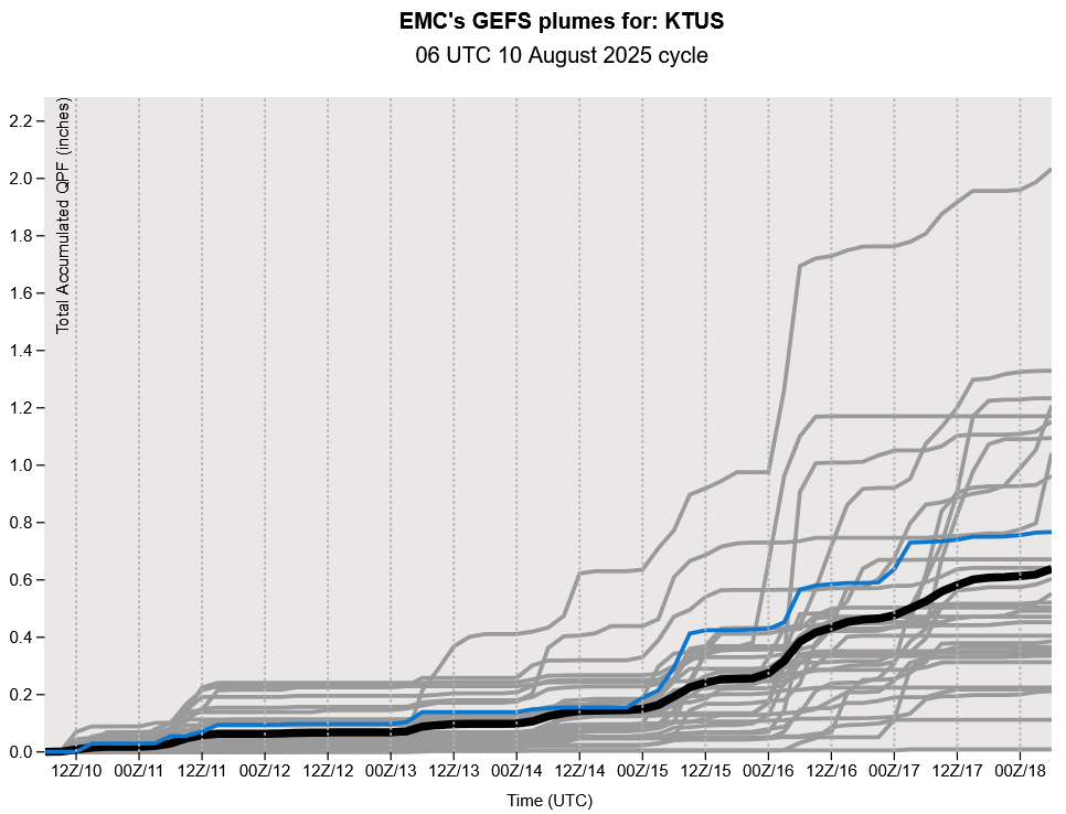
The GEFS plume forecasts are shown below with an uptick in precipitation compared to yesterday, as heavier precipitation is expected next weekend (note the y-axis scale has changed to 2.2 inches).
Discussion written by Pat Holbrook and Patrick Bunn