
Yesterday’s Weather
Yesterday there were two areas where storms formed: northern Arizona to northern New Mexico and in southwest Arizona near Lukeville/Ajo west to Yuma. The rest of the state was dominated by the subsidence around the high pressure ridge centered over the four corners region. The visible satellite imagery and lightning strike data shows where the thunderstorms were located.
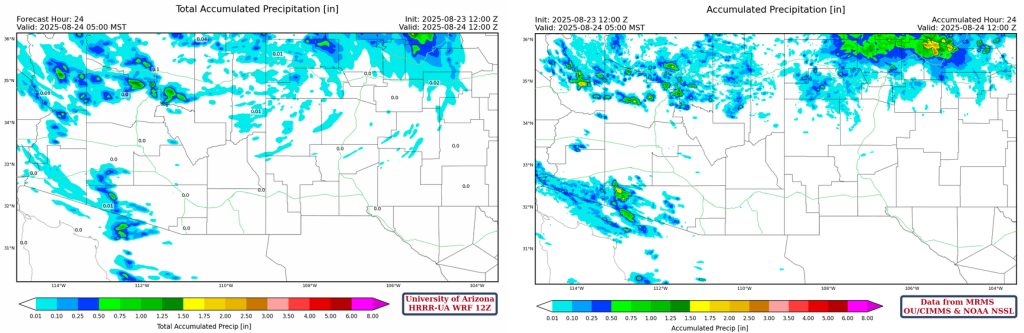
Ajo measured 0.4 inches and the Yuma area also had rain in the buckets like what is shown in the gridded 24-hour accumulated precipitation map from MRMS below. To the north, Kingman had .03 inches, but a RAWS site in the mountains had over a half inch of rain. They even had rain in the Grand Canyon with Phantom Ranch recording .03 inches.
Analysis
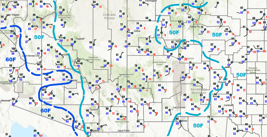
Dry air at the surface is over the southern half of New Mexico extending into southeast Arizona. The rest of Arizona has dewpoint temperatures in the 50°Fs and 60°Fs.
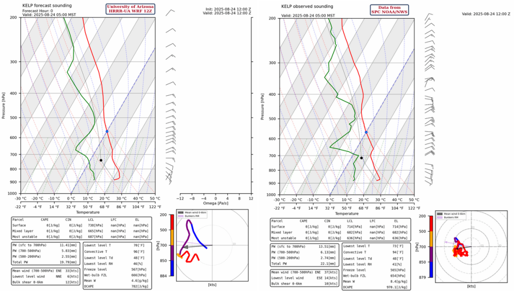
The 5am observed sounding at Phoenix is available, but there is low level contamination which gives an unrealistic precipitable water value. Shown instead, the El Paso sounding from 5am this morning has a subsidence inversion at 400mb and a precipitable water value less than an inch.
The visible satellite image this morning shows showers and thunderstorms in northern and southwest Arizona. Mid-level clouds are in eastern Arizona and the northern half of New Mexico.

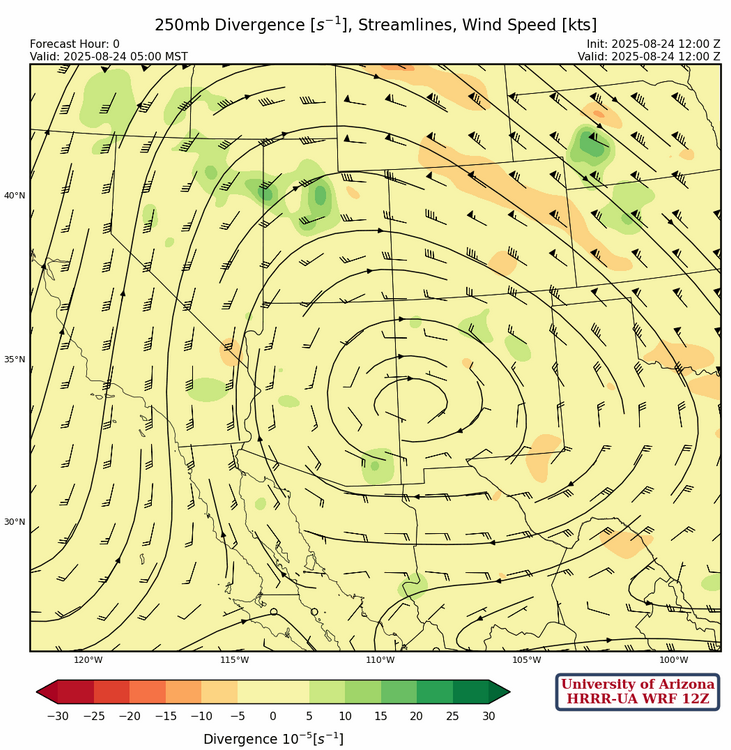
The tropical upper tropospheric trough (TUTT) and associated low pressure centers are shown below. The two ridges in the tropics are related to developing tropical systems.

At 250mb, the ridge is beginning to move back towards Texas and will be in the Texas hill country in a couple of days. A trough is in the Pacific Ocean west of the Baja Peninsula and the retreating ridge will increase southerly winds aloft over Arizona ending the subsidence inversion. Upper-level divergence will become more favorable for thunderstorm activity Monday and Tuesday.
Temperatures have already cooled a couple of degrees at 500mb and should remain about the same over the next few days except in areas where there is induced cooling due to the thunderstorms. Winds have weakened a little and will become from the southeast to south as the ridge shifts eastward.
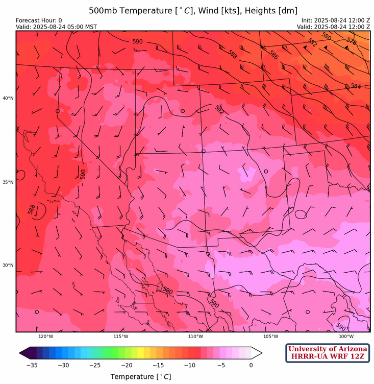
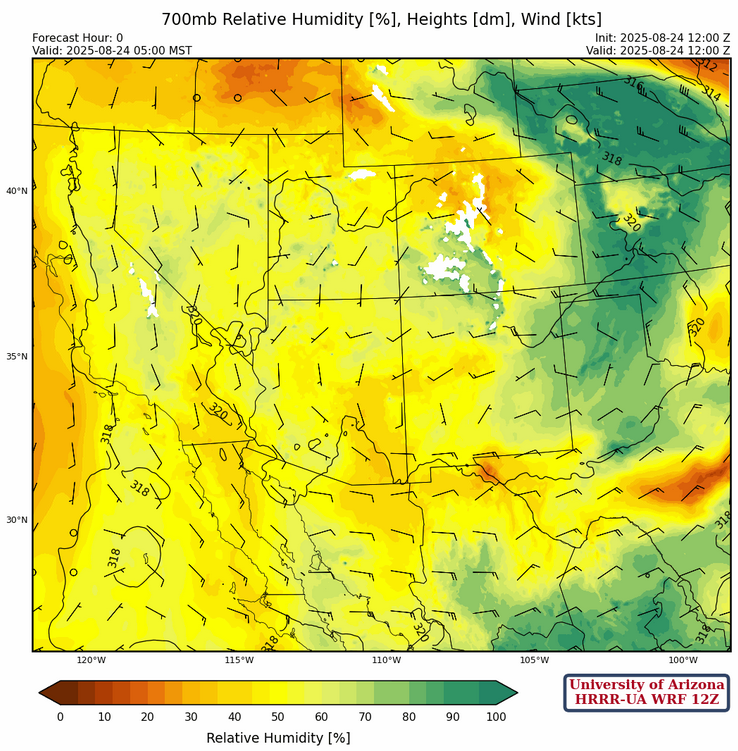
At 700mb, there are only minor changes in the moisture field from yesterday with a slight increase in northwest Arizona and southern Nevada. Easterlies are a little faster over northern Mexico.
Today
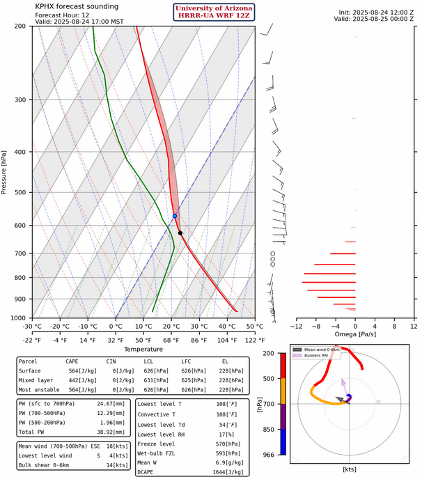
The HRRR-UA WRF 12Z forecast sounding for Phoenix at 5pm has Convective Available Potential Energy (CAPE) this evening while Tucson is still under the subsidence inversion.
This afternoon’s radar reflectivity forecast shows the storms forming west of Phoenix then moving west and northwest to California and Nevada. Once again, the forecast indicates overnight showers forming east of Phoenix and they move to the west though there are fewer overnight showers in southeast Arizona than yesterday’s forecast.
Tomorrow
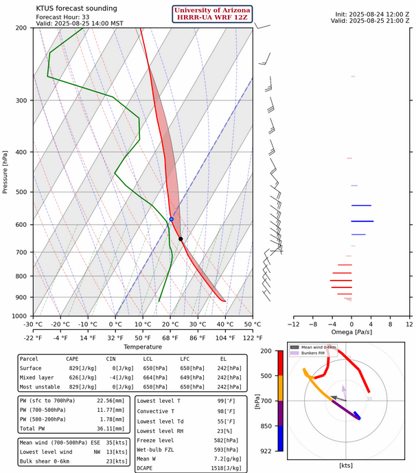
The HRRR-UA WRF 12Z forecast sounding for Tucson at 2pm has plenty of CAPE if the timing is right. This sounding may be more representative further west in Pima County (Three Points or Sells). The thunderstorms from today will increase CAPE in the low deserts and this moisture does push eastward with outflow boundaries this evening and will be reinforced by Gulf Surge moisture tonight. The only question is how far east the moisture gets during the day on Monday before storms start?
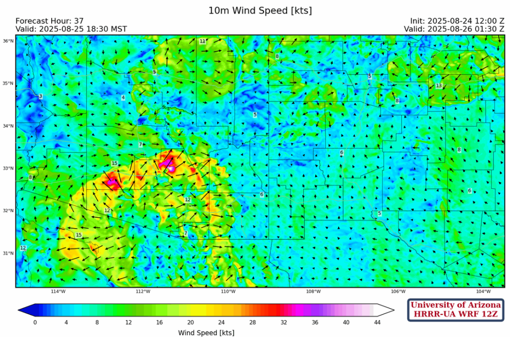
A large outbreak of storms in central Pinal County is forecast tomorrow afternoon and spreads out in all directions across southern Arizona reaching Phoenix by the evening.
Wind gusts over 50 mph will be associated with this outflow boundary along with blowing dust or a haboob. Showers will continue overnight from west of Tucson to Phoenix.
Outlook
A “down day” follows an “up day” for the low deserts on Tuesday, as the ridge shifts east and the axis of storms shifts with it. Therefore, eastern Arizona will be the focal point of the thunderstorms.

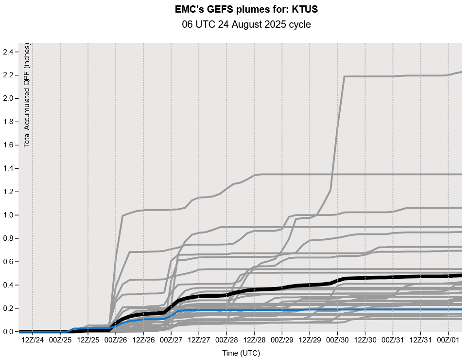
The GFS plume forecast hints that we will go into another dry spell later in the week. The long-range models indicate a couple of chances of rain the following week before the monsoon ends, though these long-range coarse grid forecasts have significant uncertainty for the small scale features associated with monsoon season.
Discussion written by Pat Holbrook and Patrick Bunn