
Yesterday’s Weather
Surge moisture resulted in the thunderstorms over the Mogollon Rim extending southeast into the White mountains and then south across Graham and Greenlee counties then eastward into New Mexico. Tucson and Phoenix had cloud cover that did not allow either location to get to it’s convective temperature, nor were there any outflows in either of the metro areas.
24-hour precipitation accumulation data from Rainlog.org for Southeast Arizona shows the rainfall was mainly in Naco, Chiricahua Mountains, and between Oro Valley and Marana. Most of the storms were making cirrus and not as much widespread rain as you might think looking at the infrared satellite loop above.

A light shower formed over northwest Tucson with a few drops hitting the rain bucket; it was missed by the MRMS observation data, but it’s on radar and in the rainlog buckets.

Rain fell along the Mogollon Rim southwest of Flagstaff with the heaviest north of Prescott.

Analysis
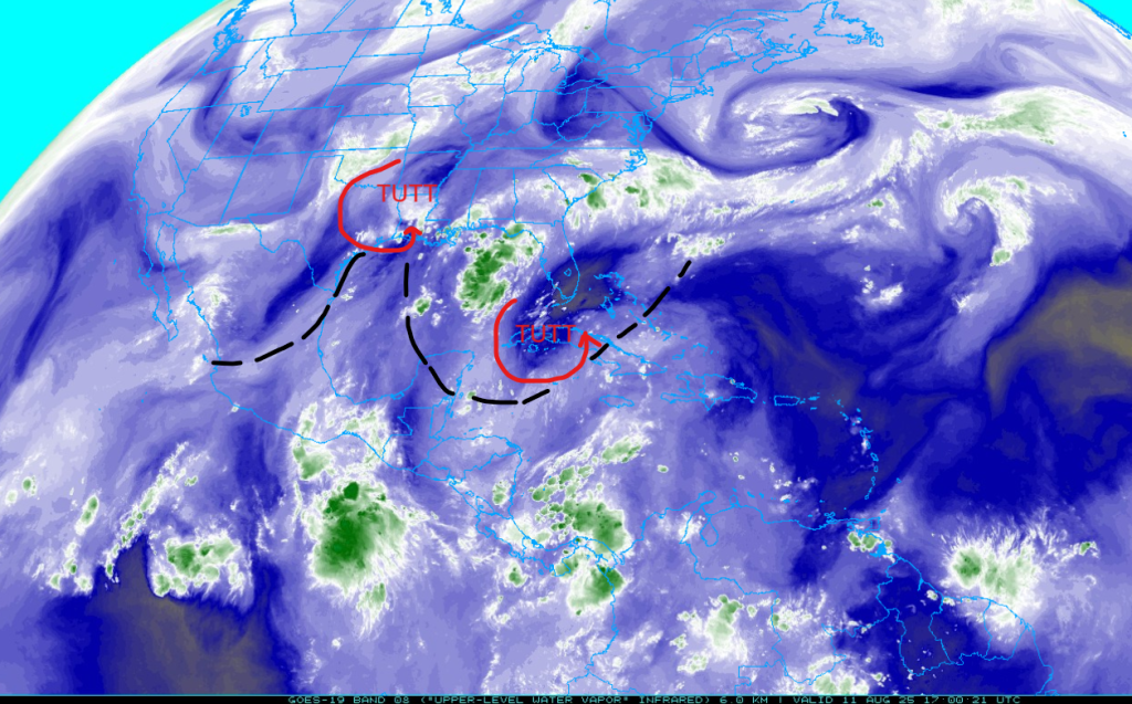
The tropical upper tropospheric trough (TUTT) over Texas is moving north ahead of the trough over the middle of the country, while the TUTT low in the Carribean Sea has a broad circulation centered west of Jamaica. I would expect the TUTT axis to reform further south as the TUTT low in Texas leaves the area.
Precipitable water is about 1.5 inches (37mm) at Phoenix which is close to the HRRR-UA WRF 12Z initialization this morning at 35.5mm (within measurement uncertainty). The drawback is wind flow pattern above 500mb from the north, meaning anvils will blow over the where storms would initiate preventing the surface convective temperature from being reached.

Morning surface dewpoint temperatures remain high enough to reflect that the monsoon moisutre is present, though they will drop below 50°F this afternoon when the boundary layer starts mixing.

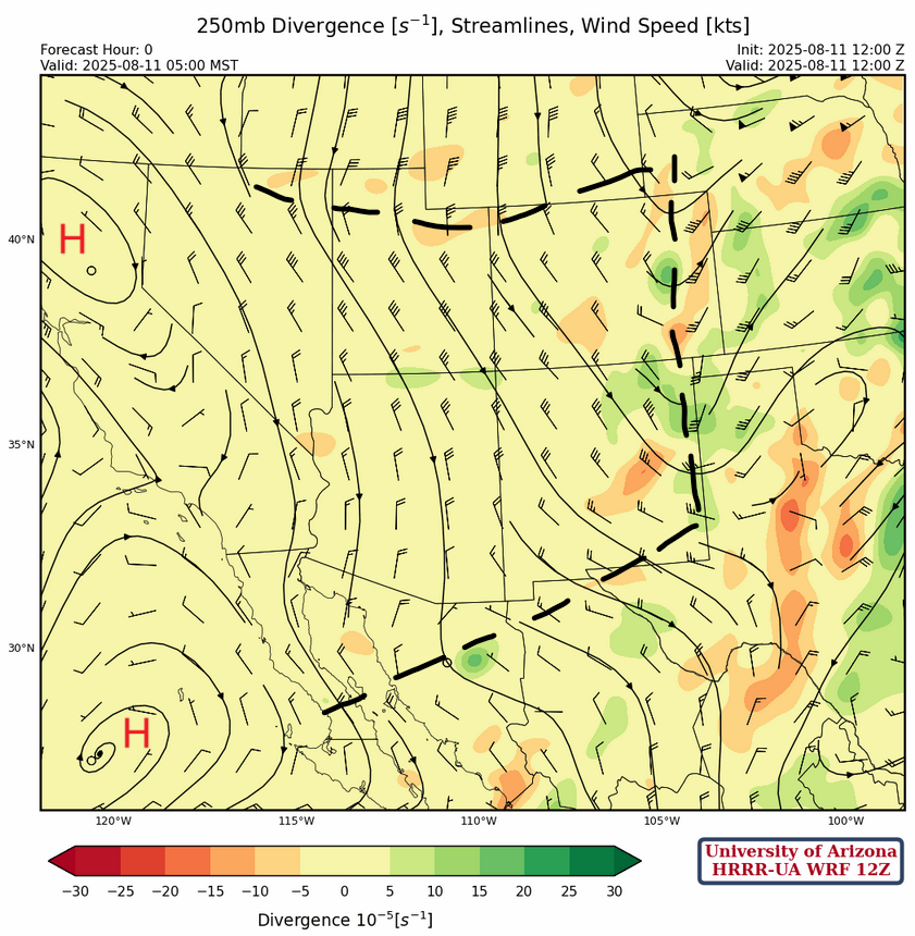
At 250mb, northerly flow is present across the Southwest U.S. region behind the trough over the Great Plains. Two short wave troughs are annotated, but it’s the one over southern Idaho and western Wyoming that will play a role in our weather this week.
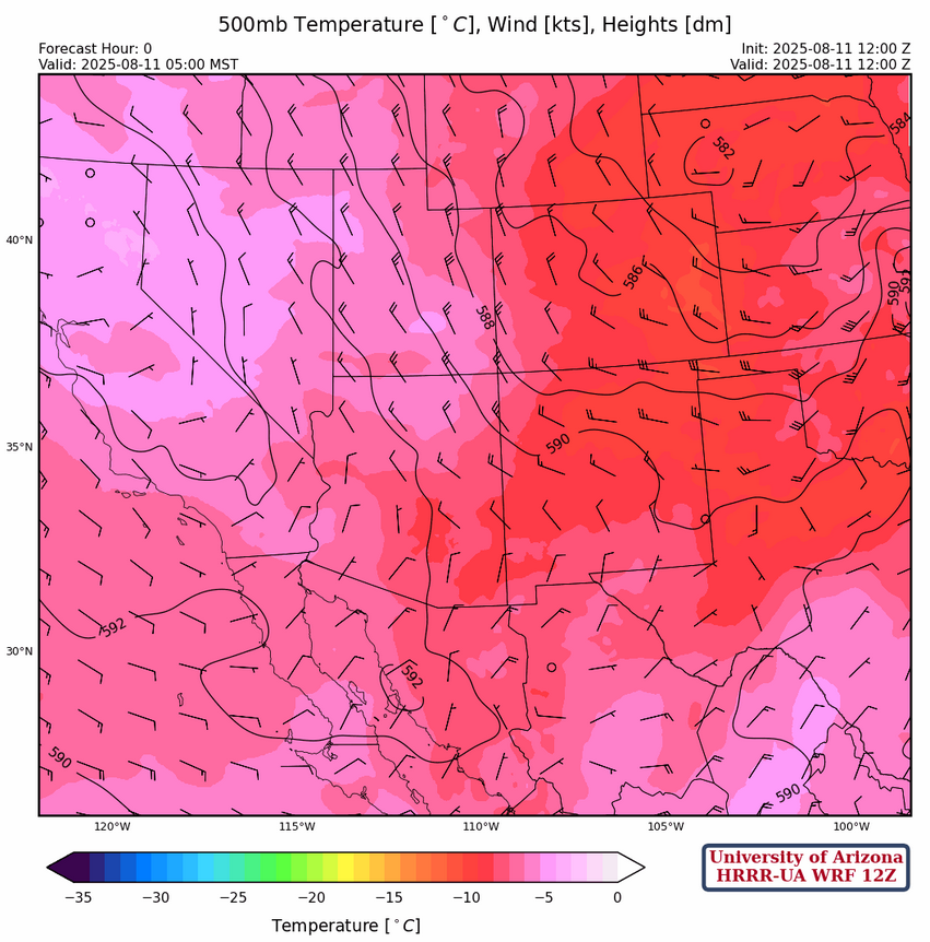
Arizona and New Mexico are on the back side of a trough with a center in western Nebraska at 500mb. Generally, northwest flow is over the two states, although a little more westerly in New Mexico.
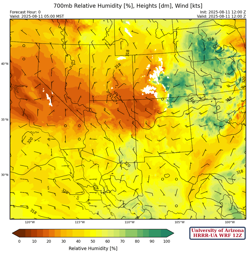
At 700mb, drier air is filtering into the northern portion of Arizona and northwest New Mexico. Note that the deep easterlies in Mexico associated with the monsoon have been suppressed and are well to the south compared to a more typical monsoon pattern.
Today
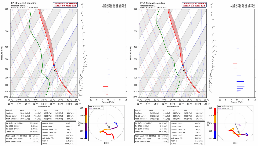
The Phoenix (left) and Tucson (right) forecast soundings at 4pm show thermal wind is from the northwest in Tucson and near zero in Phoenix. Neither of these soundings are promising for storms in the valley.
Get used to looking at this pattern in the radar refelctivity forecasts, as each day in the next few will fire thunderstorms in the mountains, but they are unlikley to move into either Tucson or Phoenix. Storms do produce microbursts and blowing dust over southeast Arizona and southern New Mexico, shown by the 10 meter wind speed forecast. Some weaker nighttime showers form in Pinal, and Graham County, and move southwest across Pima, Santa Cruz, and Cochise counties.
Tomorrow
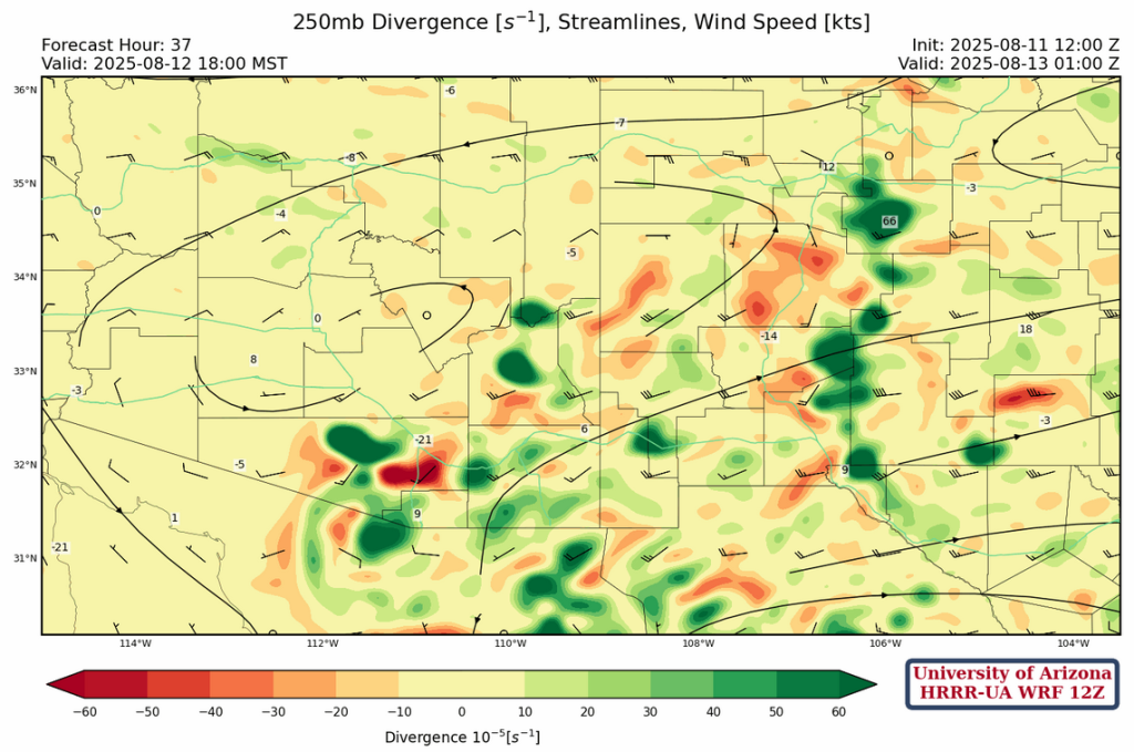
A more active day is forecast for tomorrow, as the short wave over southern Idaho and western Wyoming at 250 mb will drop down and change the northerly winds to westerly with stronger upper level divergence over southeast Arizona and southern New Mexico as shown in the forecast below for tomorrow afternoon at 6pm.
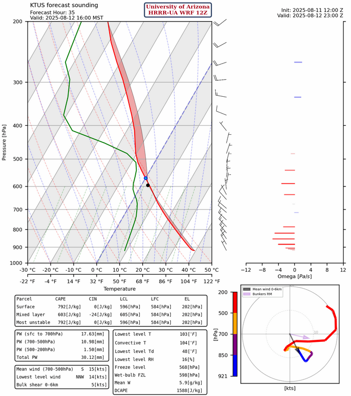
The forecast sounding for Tucson tomorrow at 4pm also looks favorable for storms, except for the westerlies in the boundary layer. Thermal wind indicates storms will move from west to east, and anvils will blow in the same direction as the boundary layer westerlies, which is a negative for getting in the storms in the Tucson valley.
By evening strong storms are everywhere in southeast Arizona and lingering overnight showers form from Phoenix south to Tucson and Nogales.

Outlook
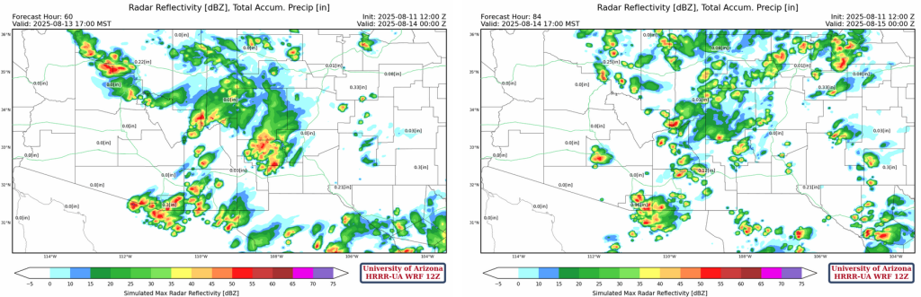
HRRR-UA WRF 12Z radar reflectivity forecasts for Wednesday (left) and Thursday (right) show a continuation of the same pattern. The positive is a little more activity on Wednesday and model forecasts hint at weakened storms moving into Phoenix metro Wednesday evening. The negative is fewer storms are forecast as the week progresses to Thursday.
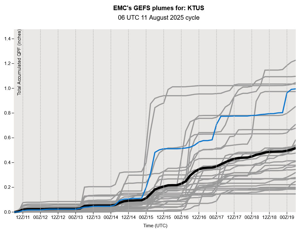
Both the ECMWF and GFS long-range models show a stronger event at the end of the week, half inch or so either Thursday (GFS) or Friday (ECMWF) depending on which model you look at. But looking at the GEFS plume for Tucson below, this is still very uncertain at this time.
Discussion written by Pat Holbrook and Patrick Bunn