
Overview
An upper-level trough (closed low) off the coast of Southern California will move northeastward across the Southwest US this weekend, bringing precipitation chances to Arizona. The rainfall is predicted to be light, ranging from trace amounts to 0.25 inches in the lower deserts and 0.5 to 1 inch across the higher terrain of Northern Arizona. Snow levels will remain above 7000 feet, and snow accumulations ranging from a dusting to a couple of inches are possible over the tallest mountain peaks. In addition, a few thunderstorms are possible mainly west of Phoenix due to weak instability.
Model forecasts show another upper-level trough impacting the region mid-to-late next week, creating another chance of precipitation.
Current conditions
As of 7:30 am this morning, mid-level water vapor imagery displays a plume of deep tropical moisture being transported into Southern California.

This atmospheric river is due to a deepening upper-level trough off the coast of California.

The amount of deep tropical moisture being transported into Southern California is quite impressive, as indicated by the San Diego (NKX) sounding from 5 am, which measured 1.36 inches of precipitable water.
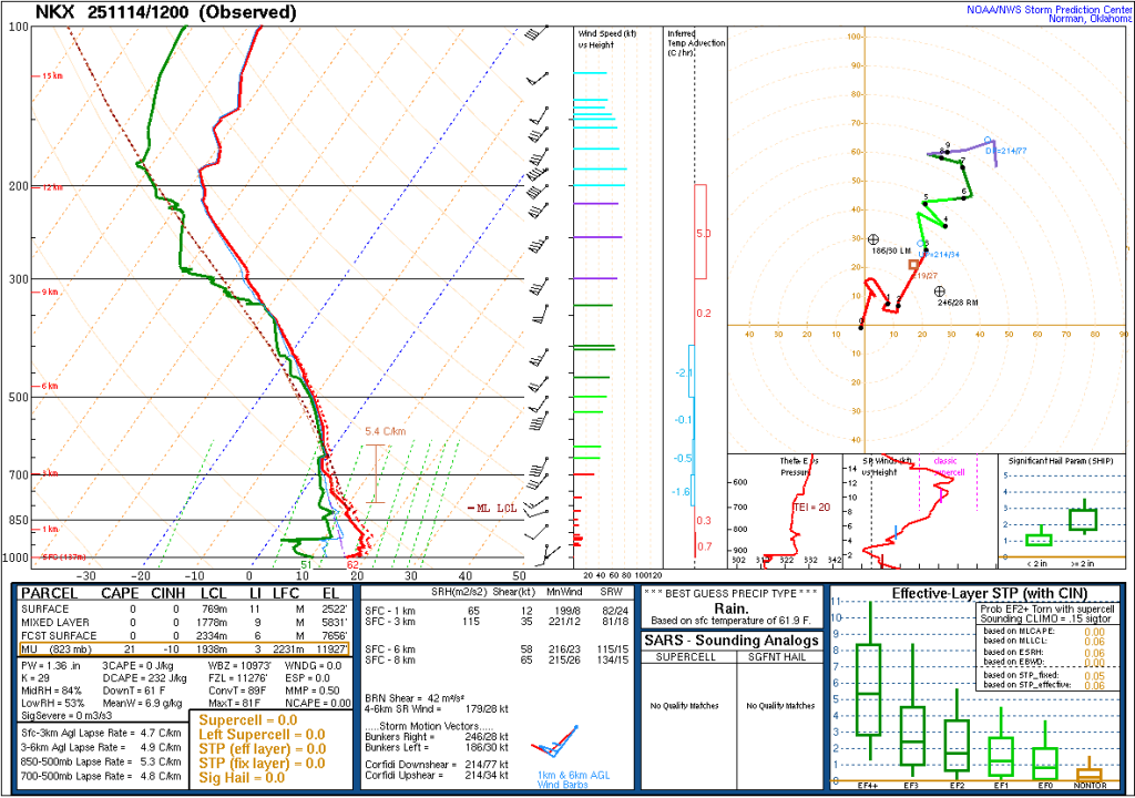
In fact, checking the San Diego sounding climatology, this observation breaks the daily record for precipitable water!

Dynamics this weekend
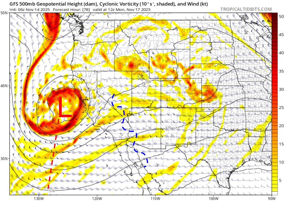
The upper-level trough is expected to deepen over the next 24 hours due to an area of cyclonic shear vorticity (jet max) upstream of the trough axis moving into the base of the trough.
It is expected to be a closed circulation by tomorrow morning, with 500mb height anomalies 3 to 4 standard deviations below climatology for this time of year.

By Sunday morning, the area of cyclonic shear vorticity will move upstream of the trough axis, which will act to weaken and lift the wave northeastward.

This movement is the main reason why model forecasts have backed off the quantitative precipitation forecasts (QPF) over the last few days, especially in Southern Arizona. However, there will still be enough synoptic-scale support for showers across half of the state, mainly focused in western and Northern Arizona.
Moisture and instability
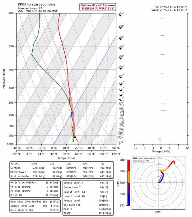
Moisture will be well above normal for this time of year with the HRRR-UA WRF 12Z showing precipitable water between 1 and 1.25 inches in Maricopa, Pima, Pinal, and Yuma counties late Saturday through Sunday evening. These precipitable water values are above the 90th percentile for this time of year based on Tucson sounding climatology.

Instability is forecast to be minimal due to weak lapse rates in the lower troposphere. The HRRR-UA WRF 12Z forecast sounding for Phoenix shows around 200 [J/kg] of Convective Available Potential Energy (CAPE). Still, some areas in the lower Colorado River Valley could see CAPE values of 250-500 [J/kg] late tomorrow afternoon.

The greatest instability in Tucson is expected late morning on Sunday, around 11 am, but the HRRR-UA WRF only forecasts around 100 [J/kg] of maximum CAPE.

Timing and amount of Precipitation
Model forecasts are in relatively good agreement regarding timing and precipitation amounts across Arizona. Both the HRRR-UA WRF and GFS-UA WRF forecast light precipitation to start in western Arizona during the afternoon hours tomorrow, with coverage and intensity increasing around sunset. The best precipitation chances for the Phoenix area will be late Saturday into early Sunday morning, and for the Tucson area, late Sunday morning into the early afternoon hours.
Total precipitation amounts will be light in the lower deserts, compared to higher elevations, due to weaker and briefer dynamic support from the upper-level trough. Only expect a trace to 0.25 inches in these areas, with locally higher amounts possible in Yuma and western Maricopa County, due to the greater risk for thunderstorms. The greatest rainfall amounts will be mainly over the higher terrain of Northwestern Arizona due to the closer proximity of the trough dynamics. Total accumulations in that area are expected to range from 0.5 to 1 inch.
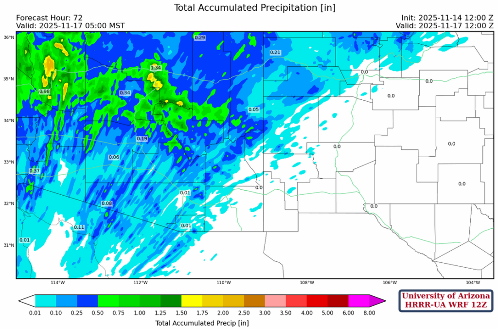
Lastly, snow levels will remain above 7000 feet through the weekend with only a dusting to a couple of inches of accumulated snow over the tallest mountain peaks. Isolated light showers are possible on Sunday evening, but they should taper off by midnight.

Next Week
The trough will lift northeastward into the Great Plains late Sunday night, with anticyclonic vorticity advection (the mechanism for sinking motion) dominating the synoptic-scale pattern on Monday as transitory ridging moves in from the west. Model forecasts show another upper-level trough moving southeastward along the California coast on Tuesday, which will likely bring another round of precipitation to Arizona. Though at this time, there’s too much uncertainty to provide any specific details with confidence.
Discussion written by Tyler Maio and Patrick Bunn