
Yesterday’s Weather
An active day yesterday with thunderstorms rolling out of Pima County heading north to Casa Grande and Phoenix. The result of the fast moving storms was wind gusts upto 70 mph and a haboob moved through the Phoenix metro area. News reports indicated this was the largest haboob in 5 years (CNN has some great images in this article). Below are the storm reports from yesterday and those in Arizona are from wind gusts from Marana northward along I-10.

The satellite imagery with GLM lightning flash data shows the storms that produced the haboob just south of I-8 at 4pm. By 5pm storms were in Phoenix, but they were a new development probably due to the haboob/outflow from the Casa Grande area and not the storms along I-8 earlier. Still the motion of the storms was 30 mph+.
The infrared imagery also covers a large area compared to the actual size of the storms and it is best to locate storms under the cirrus canopy using lightning strike data or better radar reflectivity (shown below). Convective initiation was forecast well by HRRR-UA WRF 12Z (below, left), although there were more storms further west along the international border than was forecast. Storm propagation was reasonable in the forecast, though the movement of the storms from Pima and Pinal counties was more northward than westward, as predicited. No current forecast model would be able to predict the exact interations between storms on this spatial scale (meso-gamma) and the discrepency between the observed sounding versus the forecast initialization, mentioned in yesterday’s discussion, could have been a factor in this.
The rain gauge data below has the 24-hour precipitation accumulations for Phoenix and Tucson. For Phoenix, yesterday is likely to be the heaviest rainfall event of the season!
The gridded 24-hour accumulated precipitation observations from MRMS (below, right) are in good agreement with rain guage observations. The two-inch rainfall near the Catalina’s forecast by the HRRR-UA WRF 12Z (below, left) was confirmed by a rain gauge value of 2.18 inches with a couple of the Pima County Flood Control District alert gauges recording nearly 1.5 inches.

Analysis
The surface weather station observations this morning reflects the increase in dewpoint temperatures over most of Arizona after the rain yesterday. An increase in moisture is noted even where it didn’t rain yesterday, from southeast Arizona into southern New Mexico.

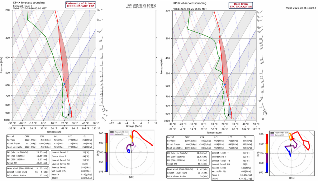
The observed sounding from Phoenix at 5am (below, right) is affected by the remanents of storms yesterday, so the moisture values are probably too high, but winds look trustworthy. There’s a better agreement with the HRRR-UA WRF 12Z forecast initialization (below, left) today though compared to yesterday.
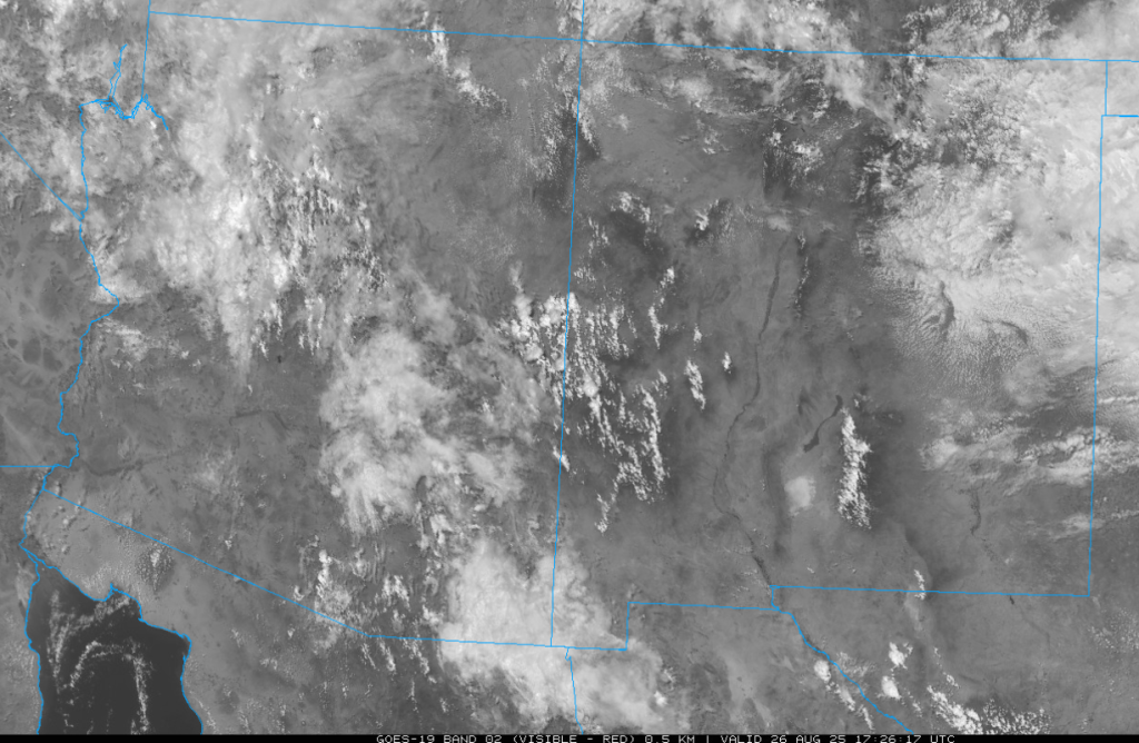
The visible satellite imagery this morning shows a lot of mid-level clouds, but where it is clear in the mountains showers are starting to develop already. Some showers are approaching Kingman in northwest Arizona.
The tropical upper tropospheric trough (TUTT) and centers of the lows are shown on the upper-level water vapor image below. There has been only a minor change in the position of the TUTT north of Tropical Storm Juliette over the last few days.

At 250mb, a trough (axis marked in black dashes) has undercut the ridge, and the center of the ridge has shifted eastward into southeast New Mexico. Broad divergence aloft is over northwest Arizona but this will lessen as the trough axis shifts to the north. The high pressure ridge indicated near the boot heel of the Baja Peninsula will follow the trough and move into northwest Mexico tomorrow.

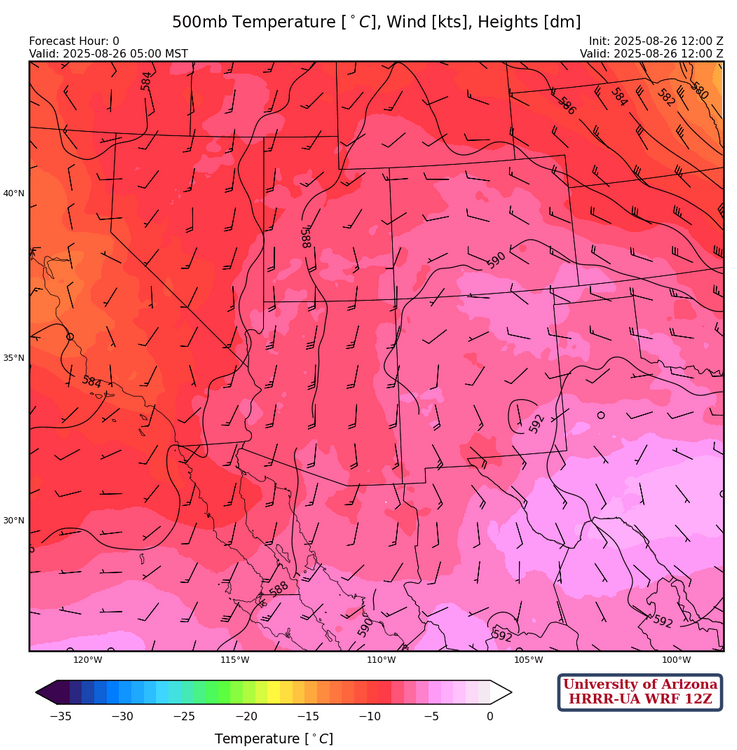
The trough off the west coast and the ridge in Texas are creating a southerly flow aloft at 500mb. Temperatures are still colder than normal creating a favorable convective environment.
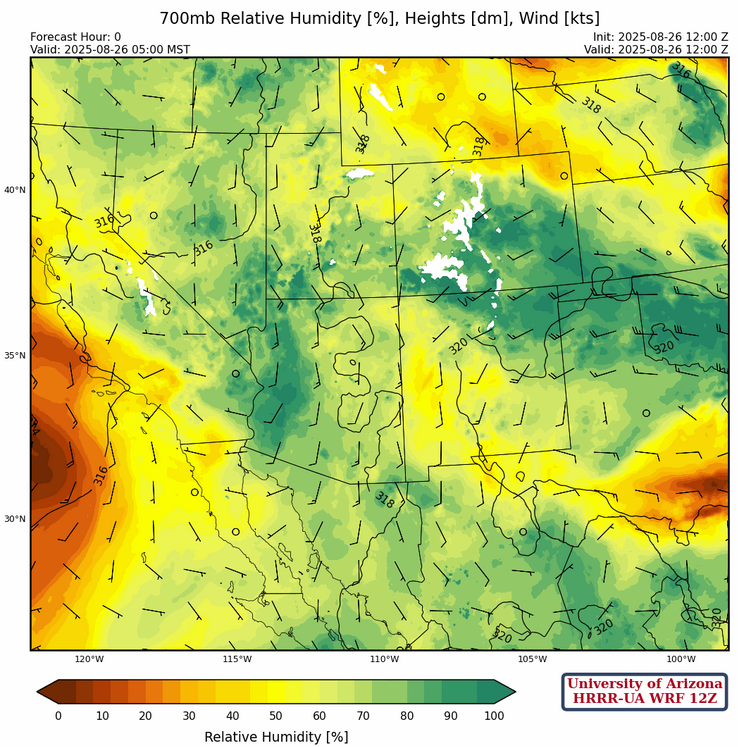
At 700mb, storm activity increased the moisture over Arizona and even southern New Mexico has an increase. In northeast New Mexico, moisture increased due to storms and convergence associated with a front.
Today
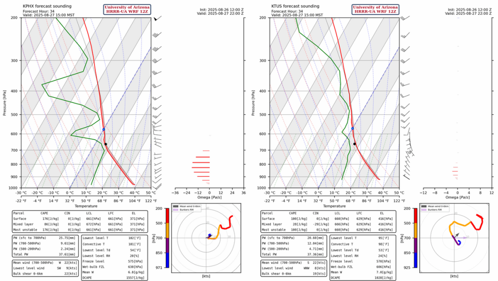
Both the forecast sounding for Phoenix (left) and Tucson (right) for this afternoon at 1pm are surprisingly similar. Given the boundary layer is pretty worked over from yesterday, storm formation should be restricted to the mountains. With brisk southerly winds moving them north, they could possibly reach the cities.

Storms will form in the afternoon in Cochise County and are forecast to move northward to the eastern part of the state. Thunderstorms will form a little later in Pima county and move into the Tucson area around 6 pm, before moving northward into Pinal and eastern Maricopa counties.
Wind gusts from the storms will be generally less than 30 mph.

The 24-hour total accumulated precipitation forecast has more than 0.5″ for Tucson from both the HRRR-UA WRF 12Z and 15Z forecast, though earlier forecasts had less than 0.1″. It’s best to expect both totals in the region with the greater totals on areas of higher elevation.

Tomorrow
The forecast soundings for Phoenix and Tucson are similar again tomorrow, but show very little Convective Avaialbe Potential Energy (CAPE). One thing to note is the moisture layer at 500mb, which is likely from Tropical Storm Juliette.
Some mid-level precipitation from Juliette into southwest Arizona is forecast late tomorrow spreading up to the Phoenix area tomorrow night into Thursday morning. Some isolated thunderstorms are also possible.
Outlook
The radar reflectivity forecast below is the rain area from Juliette around 5am Thursday morning. The rain is not particularly heavy, but lasts for several hours.

Thursday afternoon/evening, Prescott is forecast to get nearly a half inch and some of the mountains may get more than an inch. Other storms will form in Santa Cruz and Cochise counties in the afternoon and evening.

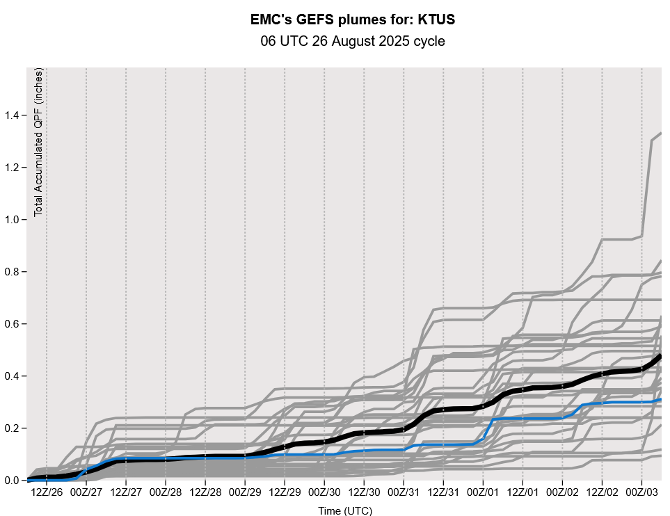
Thre GEFS plume forecast still shows a dry spell for the Labor day holiday and then activity picking up again next week.
Discussion written by Pat Holbrook and Patrick Bunn