

Summary
The subtropical high-pressure system is over the Four Corners with good southeasterly flow into Arizona, and sufficiently cool temperatures at 500 mb. A Tropical Upper Tropospheric Trough (TUTT) is situated offshore of Los Angeles, with another moving northwest up the Gulf of California; they are aiding moisture transport into the region. Strong southeasterly winds are expected to bring moisture into Southern California and southern Nevada. Satellite imagery and surface dewpoint observations show persistent moisture in Arizona and increasing moisture in southwest New Mexico, along with remnants of previous storm clusters
UA WRF forecasts for today indicate thunderstorms will develop in southeast Arizona and move west toward Tucson, possibly reaching Tucson, but weakening as they move. Tomorrow, flow changes to southwesterly due to the influence of an approaching mid-latitude low-pressure system off the West Coast. More storms are forecast in northern Arizona and New Mexico tomorrow, accompanied by strong winds, hail, and potential heavy rainfall. The convergence zone between the West Coast trough and the monsoon high remains a focal point for precipitation into Thursday, but storm activity is expected to decrease and become more localized near mountains as the week progresses and monsoon moisture is cut off.
Yesterday’s Weather
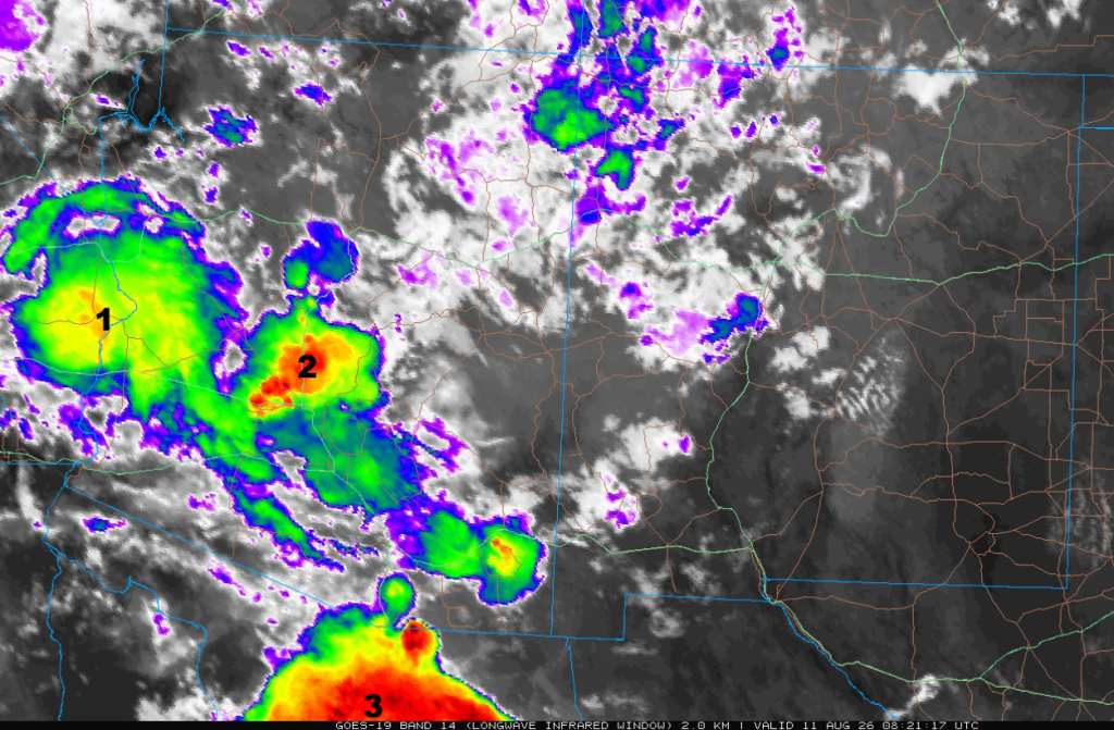
A strong cluster of thunderstorms (annotated “1” below) developed south of Tucson yesterday afternoon and moved west across central and western Pima County around the periphery of the monsoon high, and then northwest to Blythe, California before weakening in eastern California.
A second cluster of thunderstorms (“2”) developed in southwest Graham/northwest Cochise County and moved northwest east of I-10 in Pinal County. Additional thunderstorms developed in the Phoenix metro area; the forecast propagation direction was incorrect, as they moved northwest rather than west. The cluster of thunderstorms has now moved between I-10 and I-40 in northwest Arizona.
Another cluster of storms (“3”) moved from Mexico 100 miles south of Nogales, northwest into central and western Pima County, and is now along I-8 between Yuma and Casa Grande. The three clusters are shown on the satellite picture below at 1:20 am.
Tucson mostly missed out on the storms, with an isolated thunderstorm having a 59-mph wind gust at Davis-Monthan AFB at 7:07 pm. Here’s a clip of it on the Rincon cloud camera:
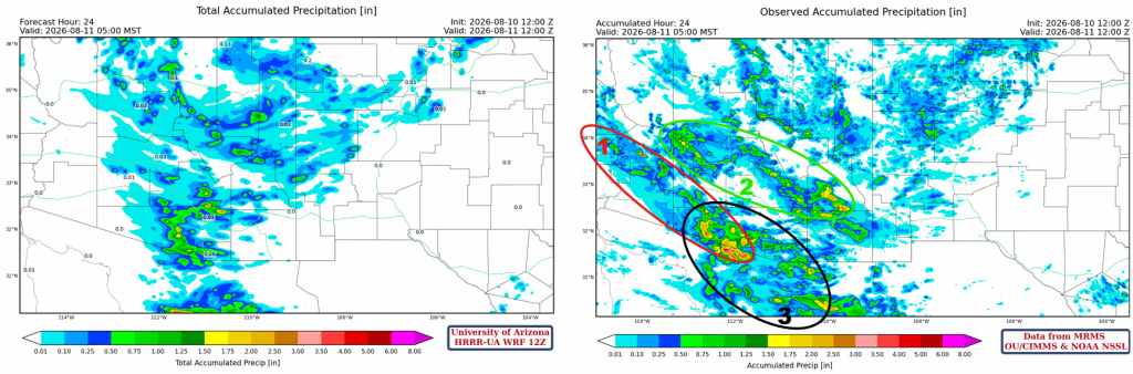
The HRRR-UA WRF 12Z 24-hour accumulated precipitation forecast (left) and corresponding observed precipitation from MRMS (right) are shown below. Clusters 2 and 3 contributed most of the forecast error shown below, although cluster 1 went farther west than forecast. The storms in northern Arizona and northwest New Mexico were forecast well.
Here’s the forecast radar reflectivity (left) comparison with observations (right). Convective initiation was well forecast, but downstream development and the more northward component of storm propagation direction weren’t right in the forecast.
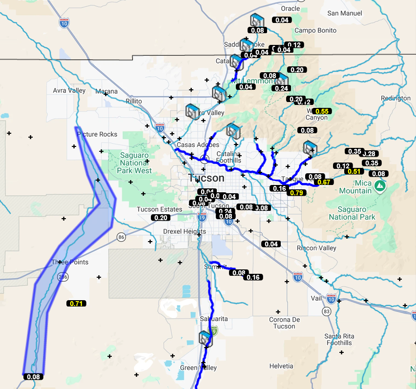
The Pima County Flood Control District shows rainfall was mostly over and near the mountains, with the heaviest rain along the Tanque Verde wash in the Rincon Mountains (0.5-0.75”). However, this morning the water in the wash was only running half a foot deep.
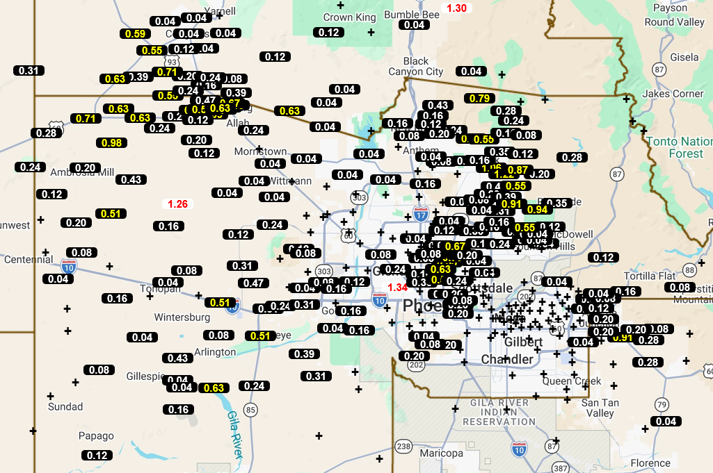
The Maricopa County Flood Control gauges below show rainfall totals mainly from thunderstorms in cluster 2.
Analysis
The Tropical Upper Tropospheric Trough (TUTT) influencing our region is a little easier to find today, just offshore of Los Angeles. Further south over the Baja Peninsula, another TUTT is moving northwest up the Gulf of California. A new circulation around another TUTT is in the Gulf of Mexico.

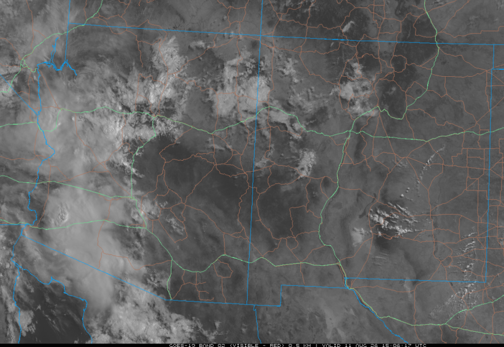
The visible satellite image from 8 am shows remnants of storm clusters 2 and 3 in western Arizona. Mostly scattered clouds are in the rest of the region.
There is not much change in surface moisture since yesterday, with Arizona very moist and New Mexico relatively dry, although moisture has moved further west into southwest New Mexico.

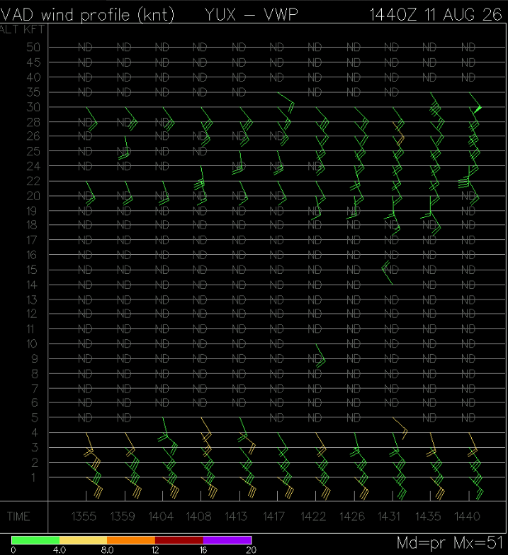
The Velocity Azimuth Display Wind Profile from Yuma this morning shows a strong thunderstorm outflow of 25 to 30 knots from the southeast. This moisture is destined for the low-desert areas of Southern California today and up to southern Nevada tomorrow.
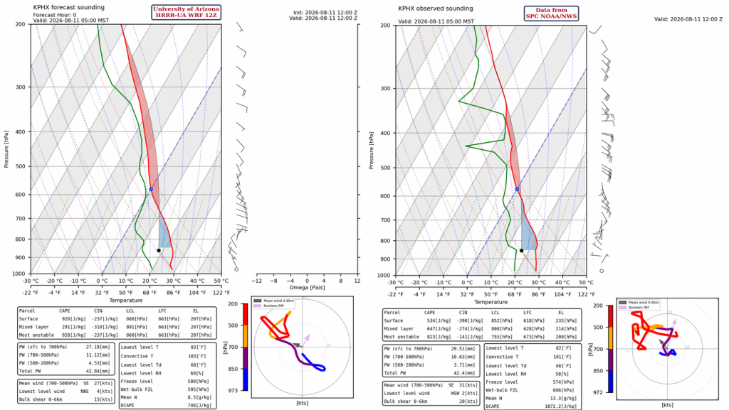
The surface data on the observed SkewT is disrupted by the overnight thunderstorms. The most useful observation is the winds above 700mb; the southeasterly mid-level winds should propagate storms northwest later today, with anvils moving just a little to the right (more southerly) of the mid-level winds. Phoenix will not get surface-based storms today, but storms in southeast Arizona will move into the area overnight.
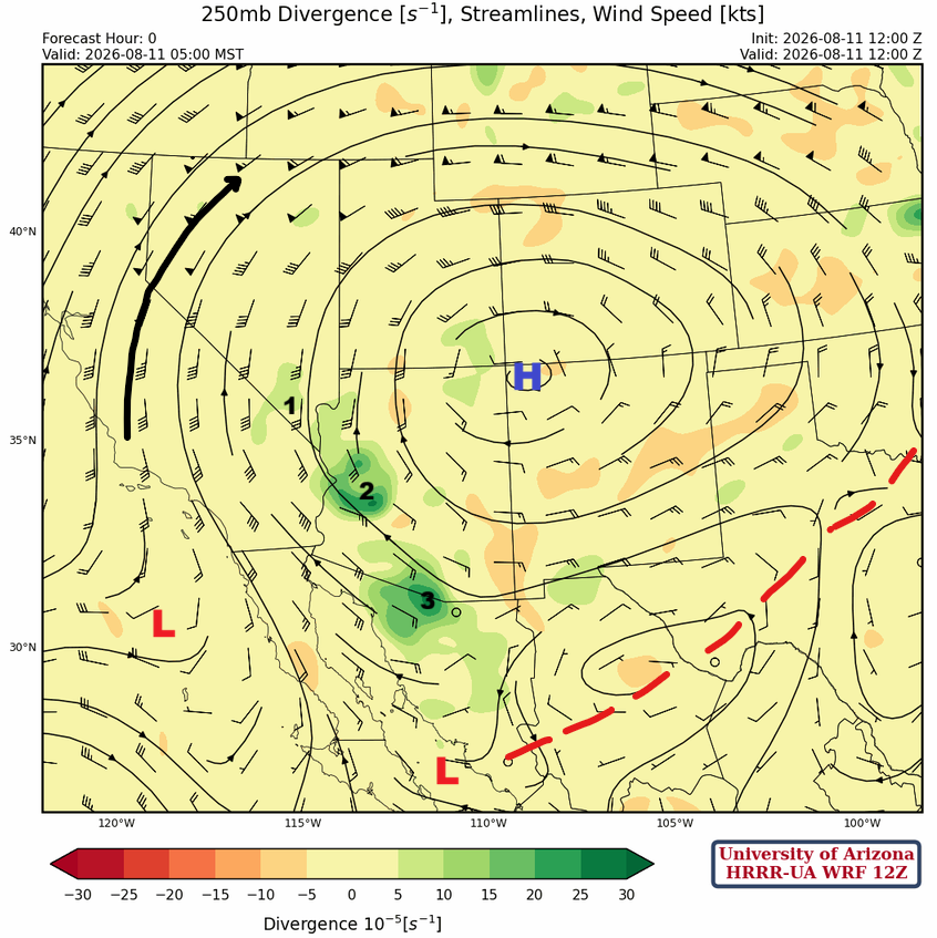
At 250mb, the monsoon high is over the Four Corners. The divergence from the three storm clusters is observed at this level (annotated in black). The TUTT off the coast of LA is about to get pulled north and weaken ahead of the incoming trough to the West Coast. The TUTT in the Gulf of California will continue to move northwest along the Baja Peninsula.
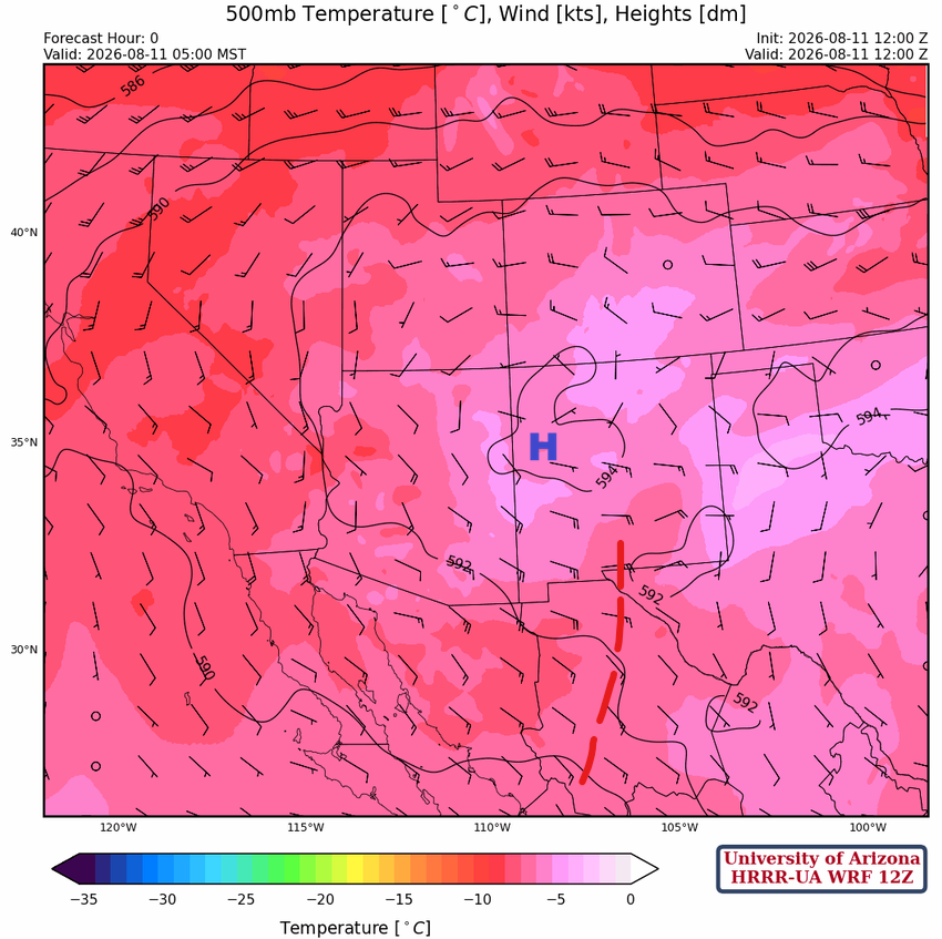
At 500 mb, the monsoon high is a little further east of its 250 mb position, with a short-wave trough rotating westward underneath the ridge. Colder air aloft is over southern New Mexico and will probably aid the development of thunderstorms in southwest New Mexico and southeast Arizona later today.
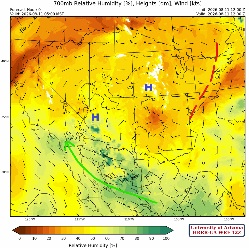
At 700mb, the monsoon ridge extends from southwest Colorado to northern Arizona. The monsoon flow is being guided by the monsoon ridge and will soon be drawn even further north into California and Nevada ahead of the trough and jet stream that will be moving into the West Coast later in the week. There is still dry air across New Mexico along with a short-wave trough that extends up to Nebraska.
Today
The 12Z HRRR-UA WRF forecast for Tucson (left) has thunderstorm development around 7 pm, while the San Simon sounding (right) shows thunderstorm development at 4 pm. The storms around San Simon should move west towards Tucson.

The HRRR-UA WRF 12Z forecast radar reflectivity shows thunderstorms initiate in northern and southeast Arizona. By 7 pm, storms are approaching Pima County from the east. Although the forecast has the storms ending before reaching Pima County, they may push into Tucson, although they will probably be weakening. Other storms are in northern Arizona and parts of western New Mexico. An MCS will develop well south of the international border with showers and thunderstorms moving into southeast Arizona around dawn
Tomorrow
Tomorrow, most activity will be in northern Arizona and New Mexico as the flow changes to southwesterly. Storms will be accompanied by strong winds and hail, and there is also potential for heavy rain due to training of thunderstorms.
In the evening, additional thunderstorms develop in central Arizona near Phoenix and in far northwest Arizona and near Las Vegas. These storms continue overnight and are being forced by upper-level flow from the West Coast trough, with positive vorticity advection helping the air rise.
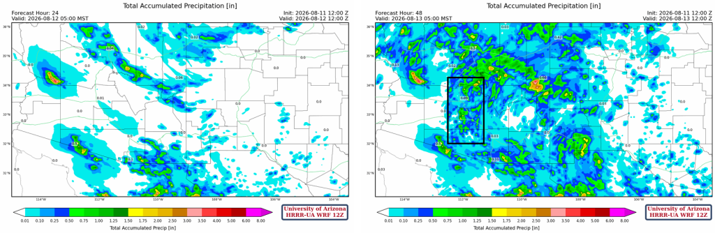
The total precipitation through 24 hours (left) and 48 hours (right) is below. The boxed area is the convergence zone between the west coast trough and the monsoon high. This boxed area may be further west or east depending on the exact position of the trough/monsoon ridge.
Outlook
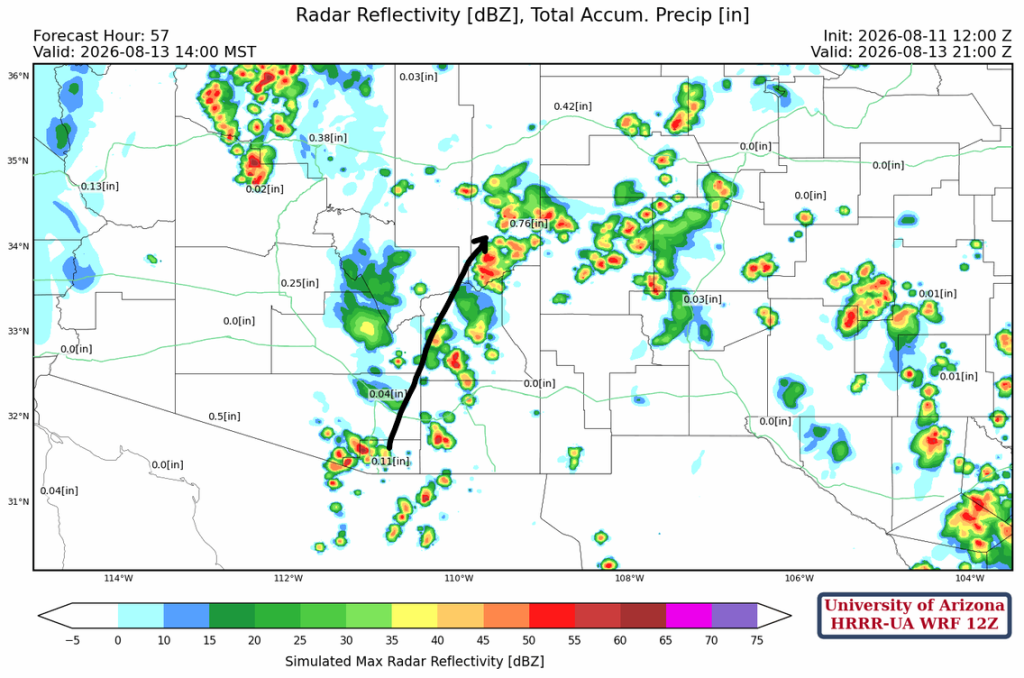
The convergence of the trough and the monsoon ridge shifts further east (black arrow) and weakens on Thursday. There is an overall decrease in thunderstorm coverage, and most will remain near the mountains.
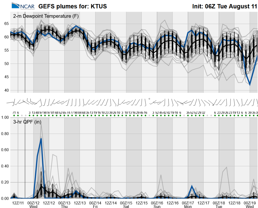
Long-range global model forecasts show we have a couple more days of storms before the west coast trough cuts off monsoon moisture.
Discussion written by Pat Holbrook and Patrick Bunn