

Summary
A Tropical Upper Tropospheric Trough (TUTT) over the Gulf of California created a favorable upper-air environment for storm development north/west of Phoenix yesterday. Satellite imagery and surface observations indicate increased moisture in southwest Arizona from another Gulf Surge developing, while New Mexico remains relatively dry.
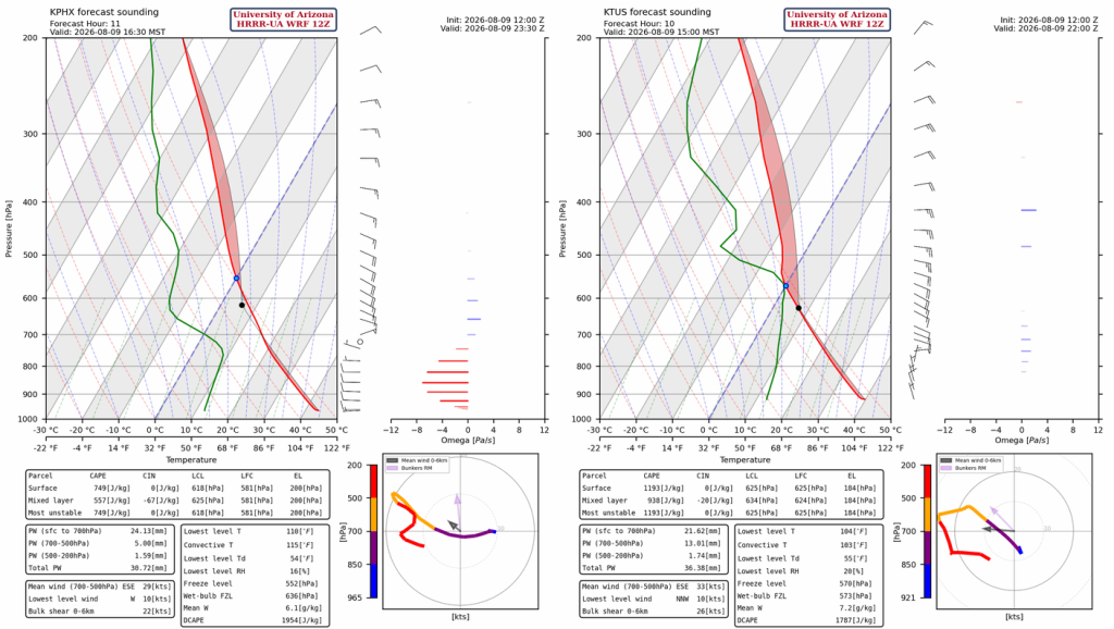
Forecasts show scattered thunderstorms today. Convective Inhibition is underestimated by the forecast initialization compared to the observed sounding in Phoenix this morning, which could be the difference between continued development of storms into the metro area or not. Light showers as the storms dissipate moving west into the valleys are more likely. In central Pima County, outflow-based additional development will overcome the CIN and will be the location of the greatest precipitation accumulations away from the mountains.
Stronger and more organized storms possible tomorrow, especially in southern and central Arizona. Rainfall is expected to be heaviest near higher terrain. Additional activity is likely early next week before a return to less active monsoon conditions by the weekend.
Yesterday’s Weather
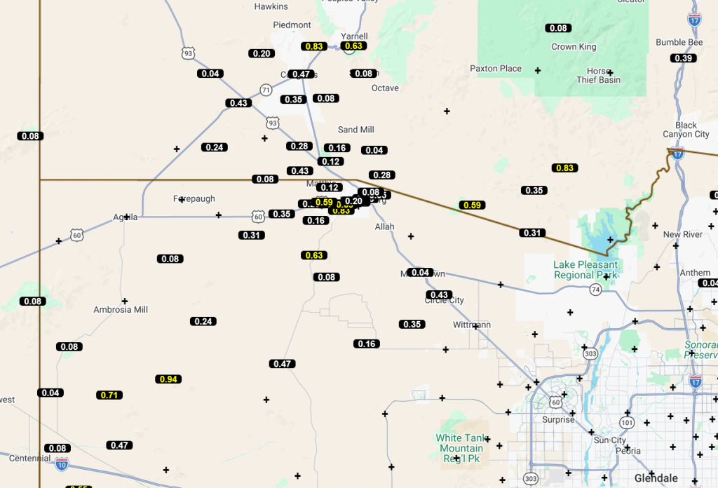
The monsoon high-pressure ridge moved north to near the Four Corners, providing an easterly wind that pushed thunderstorms off the mountain in northwest Maricopa County near Wickenburg, with rainfall reports shown on the Maricopa County Alert map below. The storms also moved south to I-10 with strong outflow winds reaching 52 mph, and visibility dropped to ¼ mile with blowing dust at Buckeye. The storms weakened before reaching the Colorado River near Parker. The 12Z HRRR-UA WRF forecast both the thunderstorms and high winds well. Thanks to Salt River Project for the 12Z upper air sounding, which improved the accuracy of the forecast in central Arizona. Other storms were in the mountains east of Phoenix and Casa Grande. Subsidence due to strong easterly winds in the southern third of Arizona and New Mexico suppressed any storm development.
Observed precipitation totals from the Maricopa County Flood Control Alert gauges.
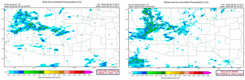
The HRRR-UA WRF 12Z 24-hour accumulated precipitation forecast (left) and corresponding observed precipitation from MRMS (right) are shown below. Except for the precipitation over the northern Gulf of California and the adjacent Baja Peninsula, the observed precipitation was in good agreement with the forecast. The precipitation in the Wickenburg area spread a little further south than forecast due to outflows initiating some additional storms.
Analysis
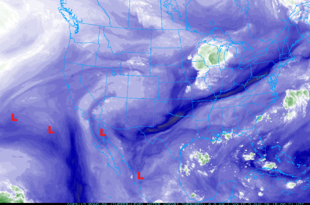
The furthest west Tropical Upper Tropospheric Trough (TUTT) moved northward west of the Baja Peninsula, dragging the TUTT to its east further eastward into the Pacific. Another TUTT formed in the last couple of days over the ocean in the Gulf of California; it provided a favorable upper-air environment for the thunderstorms last night near Wickenburg. The TUTT now over central Mexico was in the northwest Gulf of Mexico three days ago; this TUTT will move west and then north and may affect Arizona weather Wednesday/Thursday of this week.
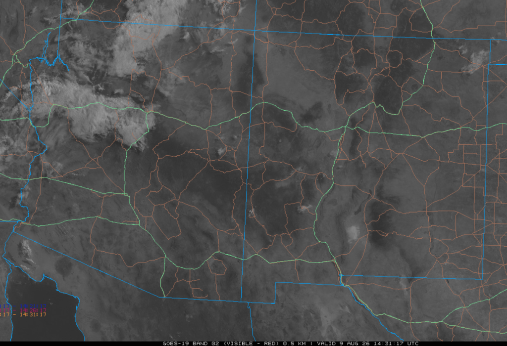
The visible satellite picture at 7:30 am shows clouds from last night’s storm in western Arizona along with a few light showers along I-40. Otherwise, mostly clear skies are over the rest of the region.
Another Gulf Surge is increasing moisture in southwest Arizona with 70°F dew point temperatures already in Yuma. New Mexico remains dry with some sub-40°F dew point temperatures along the Colorado border.

The observed Skew-T from Phoenix weather balloon launch at 5 am shows a layer in the annotated box that has cooled because of thunderstorm outflow or the Gulf Surge. The forecast initialization has this layer too warm, and it reduces more than 100 [J/kg] of Convective Inhibition in the Phoenix area. The observed CIN is –300 [J/kg] mixed-layer and -600 surface-layer, and this could be the difference between storms getting into the valley or staying in the mountains.

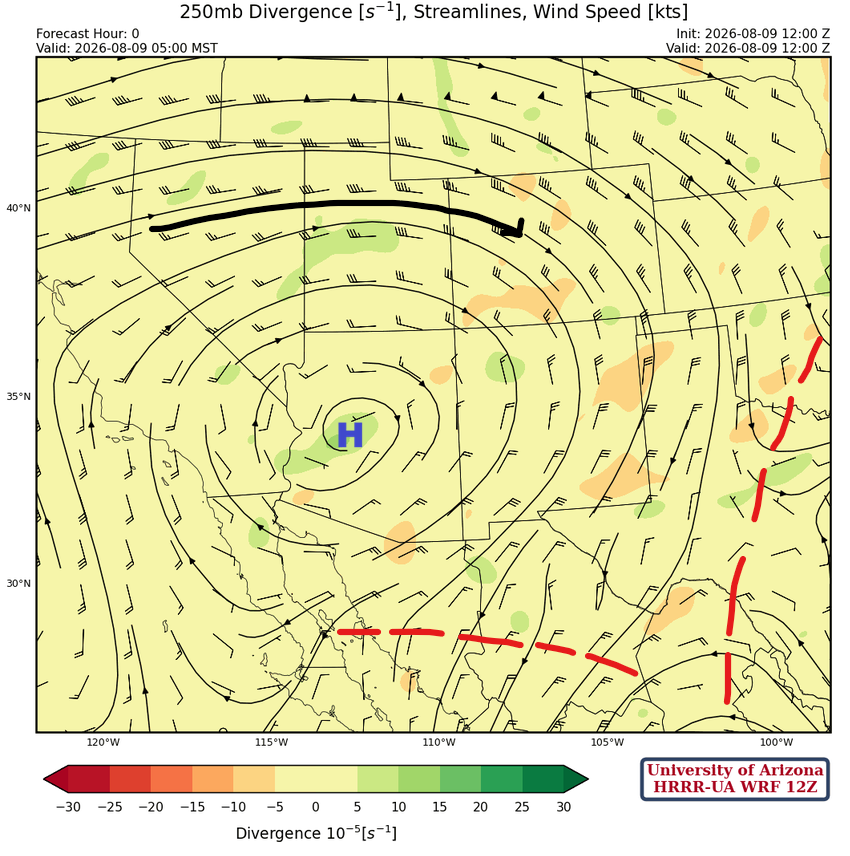
At 250 mb, the TUTT over central Mexico is further west than indicated on the forecast initialization. But in the short term, this will not affect the forecast in the Arizona/New Mexico region.
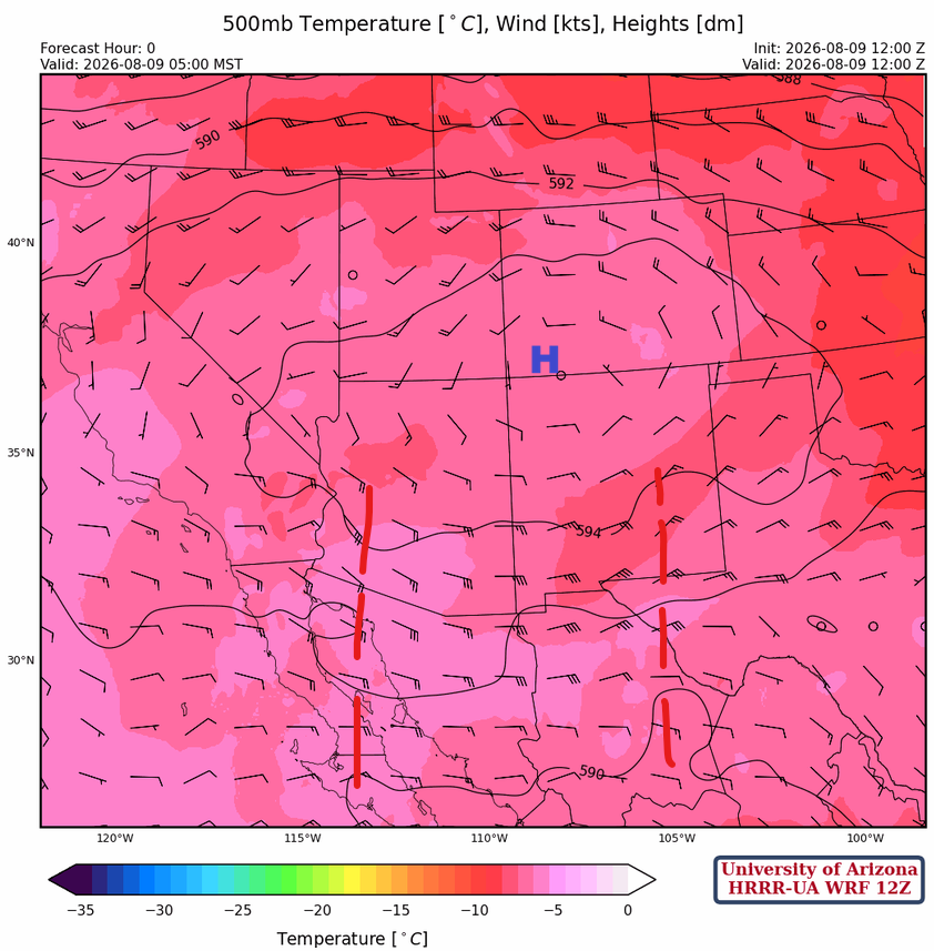
At 500mb, two short-wave troughs are rotating underneath the monsoon ridge, with the one in southeast New Mexico moving into eastern Arizona this evening. Some cooler air is also filtering into central and southern Arizona from New Mexico.
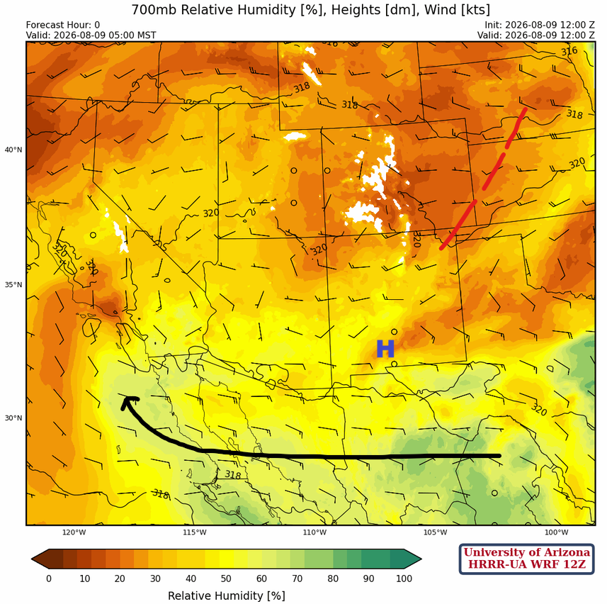
At 700mb, the monsoon flow is well established underneath the ridge. A short-wave trough is dropping southeast into Kansas and the panhandle of Texas.
Today
Persistent strong easterly winds are at around 500mb, which will delay thunderstorm development in the valleys until the evening in southeast Arizona.
The forecast radar reflectivity below shows an increase in thunderstorms in Arizona today, but storms are scattered and not organized. Strong outflows will aid storm development away from the mountains in central Pima County, just south of I-8. Storms approach Phoenix, but dissipate to light showers before reaching the metro area.
Tomorrow
Tomorrow is a much better profile for an increase in thunderstorms that will approach or exceed severe levels across the southern and central Arizona.
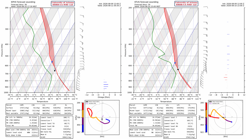
Although the forecasts show unorganized storms at this point, storms will move into Casa Grande and Phoenix by late afternoon and evening with the potential for high winds and heavy rain. This morning’s forecast for tomorrow does not show heavy rain in Phoenix, but the storms are close enough that colliding outflows can generate storms not currently in the forecast that could hit Phoenix. Storms will develop in central and western Cochise County in the evening and move into Tucson around 9 pm.
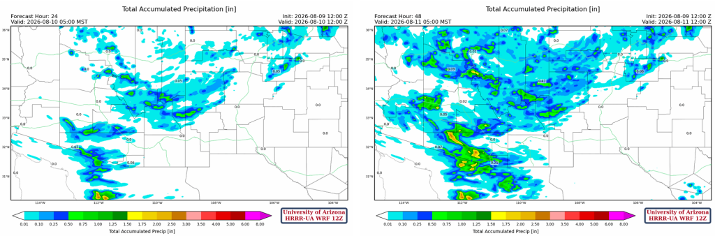
The 24-hour accumulated precipitation shows greatest totals near areas of higher terrain, compared to the 48-hour (right), which shows additional rainfall in the same areas and accumulations >0.5″ east of Phoenix and southern Pima and Santa Cruz counties by Tuesday morning.
Outlook
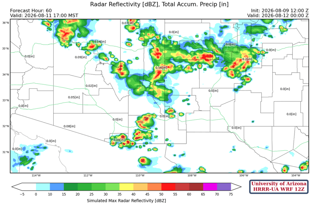
The forecast radar reflectivity below suggests that the boundary layer in the valleys and low deserts will be cooled too much by activity on Monday, meaning storms should remain in the mountains.
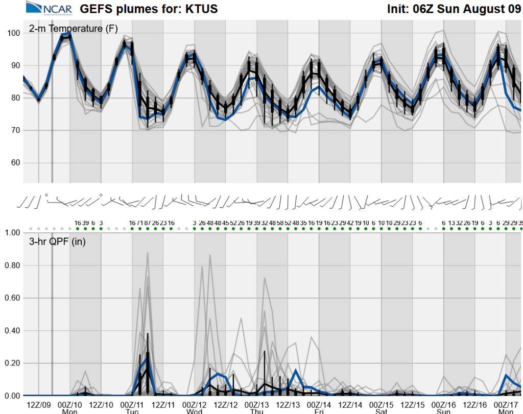
The long-range global model ensemble forecasts show next week is predicted to be more active, though by the weekend we will be back to low-grade monsoon.
Discussion written by Pat Holbrook and Patrick Bunn