
Summary
The HRRR-UA WRF 12Z forecast predicted rain too far east yesterday, while the 18Z forecast was more accurate but had a shorter lead time. Heavy rain in Pima County led to flash flooding, storm damage, and swiftwater rescues along the Santa Cruz River. In Phoenix, a single thunderstorm occurred but caused only localized rain in Mesa.
Satellite and surface observations show dry air moving into Arizona, with enough moisture remaining for possible thunderstorms in the mountains but not in the valleys. Forecast soundings for Springerville indicate high storm bases, with most thunderstorm activity expected in the mountainous regions of the Mogollon Rim and a potential for lightning-caused wildfires. Winds are expected to bring even drier air into the region, further reducing thunderstorm chances. Tomorrow, storm activity will decrease, limited mainly to the mountains of New Mexico.
Global forecast models show little chance for significant rain again until the monsoon begins, likely not until July. We’ll take a break from writing discussions while there’s no moisture around and resume on Tuesday next week.
Yesterday’s Weather
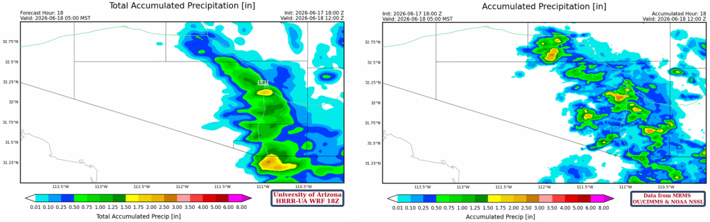
Total accumulated precipitation forecasts from the HRRR-UA WRF at 12Z (top, left) and 18Z (bottom, left) are compared with the corresponding MRMS observations (right).
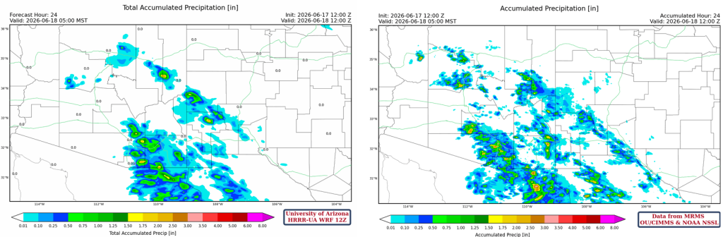

The 12Z forecast predicted the precipitation too far east, and the 18Z was just about right. Though the 18Z forecast is only available at 2 pm, just one hour before the event, whereas the 12Z is ready by 7:30 am MST. Highlighting here how forecast accuracy increases with shorter lead times, but forecasts need to be made early enough to be useful and actionable.

The Pima County precipitation gauge data is shown below. A flash flood warning was issued during the evening hours, and a severe thunderstorm knocked down 27 telephone poles. Many microbursts occurred with winds in the 40-50 mph range.

High water along the Santa Cruz River led to one person missing and eight people saved during a massive swiftwater rescue at Interstate 19 and Ajo Way. The people were in the wash before the storm, and the water rose quickly, and they could not get up the bank (Daily Star Article).
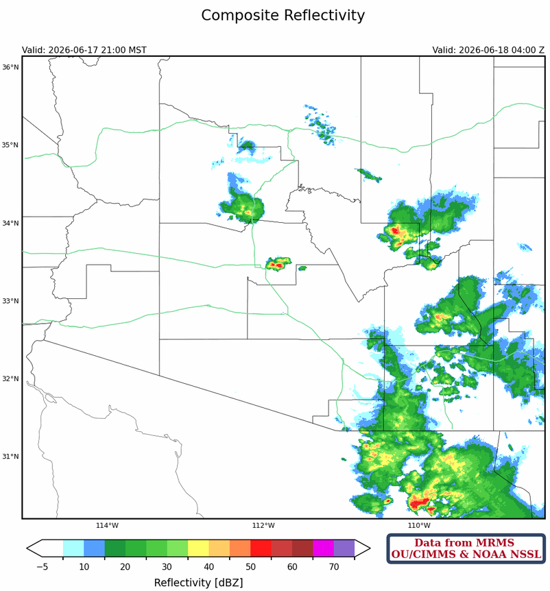
And just when I was giving up on the Phoenix area, an outflow from the storms in Pinal County resulted in the storms as indicated below at 9:00 pm. Precipitation was less than half an inch between Mesa and Apache Junction.
Analysis
The upper-level water vapor satellite from this morning shows a large area of dry air aloft moving into Arizona from the Pacific Ocean.
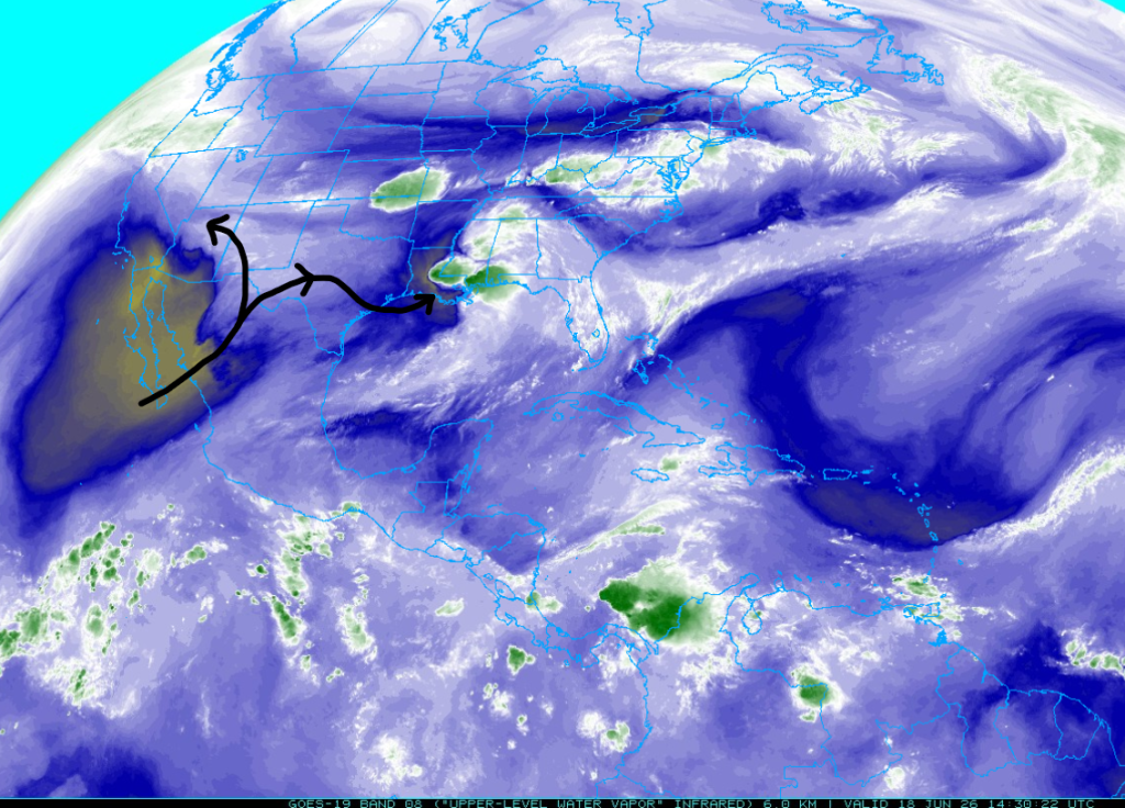
Zooming in to just the Southwest US, the lower-level water vapor also reflects the dry air. Of interest is the moisture extending from southwest New Mexico northwest toward the Mogollon Rim. This area of moisture produced light showers overnight and will aid thunderstorm development later today.

At the surface, the dry air is also moving into western Arizona. But dewpoint temperatures remain above 50°F across the southern portion of the state, though boundary-layer mixing in the valleys this afternoon should reduce moisture to pre-monsoon levels. Still, there is enough moisture to support thunderstorm activity in the mountains.

The 5am weather balloon sounding from Phoenix today shows the top of the mixed-layer inversion lowered from 500 to 600 mb this morning. The HRRR-UA WRF 12Z initialization has too much precipitable water in the lower boundary layer, whereas observations show less, mainly above 800 mb. With a high of 106°F forecast for Phoenix, convective temperatures aren’t expected to be reached this afternoon, again suggesting convection is most likely in the mountains.

Today
Below are the forecast soundings for Springerville (left) and Tucson (right) for this afternoon. For Springerville, the moisture in the area this morning will produce thunderstorms, but with storm bases around 15K feet, any rain that falls will evaporate before reaching the ground, so the main threat is lightning-started wildfires. The Tucson sounding does not support thunderstorm development, with precipitable water dropping to less than 1 inch (24 mm). However, a thunderstorm over the mountains of Pima and Santa Cruz counties is possible, as the low-level moisture we have is hard to scrub out in only a day.

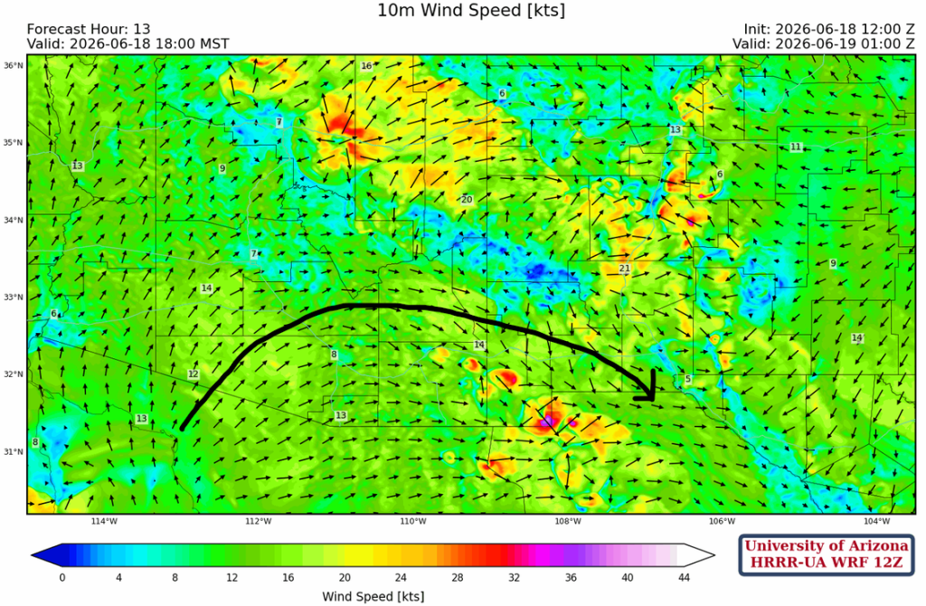
Thunderstorms forecast on the Mogollon Rim are expected to produce strong downdrafts, as are those in eastern Cochise County and southwest New Mexico.
The black line indicates the area of stronger low-level winds that are bringing in dry air, resulting in a lack of thunderstorm activity. This wind will feel like a blast furnace, especially in Graham County.
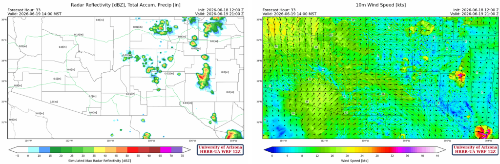
Tomorrow
An overall decrease in activity from today into tomorrow, with thunderstorms limited to the mountains of New Mexico as dry air continues to be pushed into the region from the west.
Outlook
A clean slate as far as precipitation goes through the weekend. The precipitable water animation shows the very dry air across the region through Thursday next week.
The precipitable water and precipitation ensemble forecasts from the Global Forecast System are below. There is a hint of some scattered storms next week, but until then it should remain dry until the actual monsoon flow starts. In fact, both the GFS and European global model (ECMWF’s IFS) don’t indicate any significant increase in moisture until July.

Discussion written by Pat Holbrook and Patrick Bunn