

Summary
A polar low-pressure system is approaching from the west and converging with the monsoon high-pressure that has been pushed east to Oklahoma. Positive vorticity advection ahead of the low is aiding vertical ascent in northern Arizona, and monsoon moisture continues to flow into Arizona and New Mexico, keeping dewpoints high and supporting thunderstorms with relatively little heating required for storm development.
Forecasts show that today’s thunderstorm activity will be most concentrated in northern Arizona and northwest New Mexico, with the main threat of flooding in areas like the Mogollon Rim due to slow-moving storms. The heaviest precipitation is expected in northern Arizona and northeast Phoenix, while tomorrow storms will shift toward southeast Arizona, including Tucson. After this period, monsoon moisture is expected to retreat, but moisture will possibly return later in August.
Yesterday’s Weather
The visible satellite image animation from yesterday shows thunderstorms along and north of the Mogollon Rim and White Mountains. Gulf Surge moisture also kicked off thunderstorms in southeast California and southern Nevada. The storms were isolated in the western half of New Mexico, staying near the mountains. A large cluster of thunderstorms developed along and south of the international border and moved west overnight, into Cochise and Santa Cruz counties. Heavy rain and strong winds accompanied the storms, with wind gusts over 50 mph and over 2” of rain south of Sierra Vista. Just as important is where it didn’t rain: the deserts from Tucson to Phoenix and west to the Colorado River. No rain fell in the Phoenix metro area, and in Tucson precipitation has been confined to overnight and early morning showers.
The 12Z HRRR-UA WRF radar reflectivity forecast (left) compares well to the observed radar reflectivity (right); the location of convective initiation and downstream development staying out of the lower deserts was well forecast. The overnight-to-morning clouds/showers are from MCS development in Mexico; they were a little too widespread and intense in yesterday’s forecast.
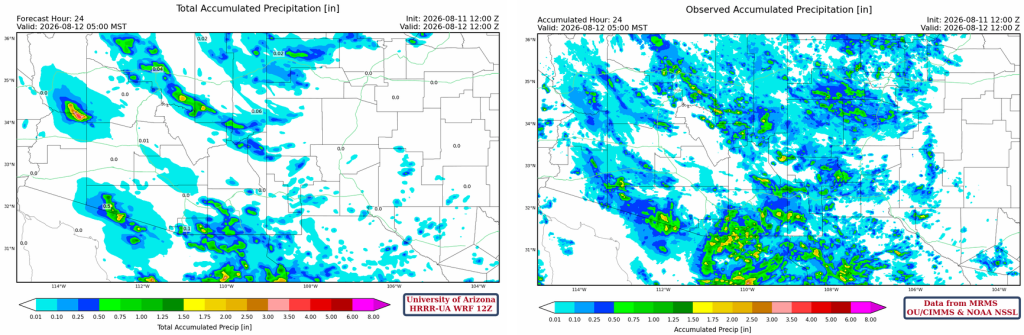
The HRRR-UA WRF 12Z 24-hour accumulated precipitation forecast (left) and corresponding observed precipitation from MRMS (right) are shown below. Generally, the forecast was good in the location of the forecast precipitation, but the accumulated amounts were too light. The HRRR-UA WRF 12Z 24-hour accumulated precipitation forecast (left) and corresponding observed precipitation from MRMS (right) are shown below. Generally, the forecast was good in the location of the forecast precipitation, but the accumulated amounts were too light. Precipitation in northern Mexico and the Mesoscale Convective Systems that have been developing there are often underestimated in forecasts, but with no observations it is likely that the Gulf Surge and thunderstorm outflows are not well represented.
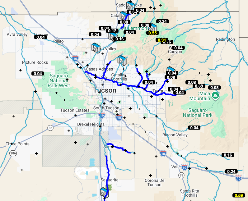
Observed precipitation from the Pima County Flood Control Alert gauges shows precipitation in the Catalina Mountains and around the edge of Pima County to the east and south.
Analysis
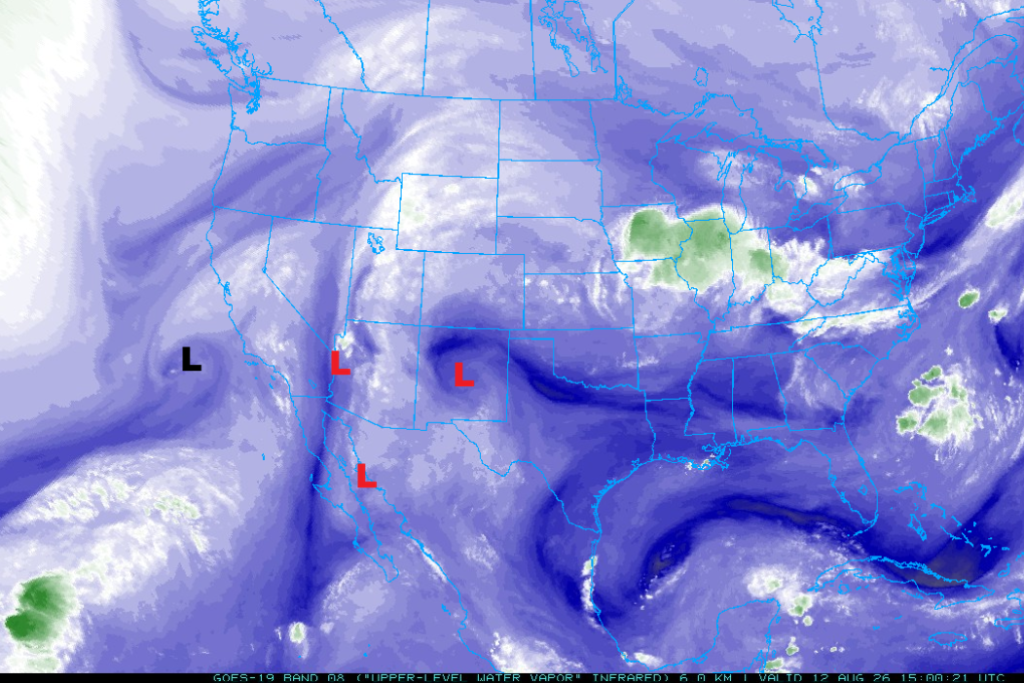
The Tropical Upper Tropospheric Troughs (TUTT) over the CA/AZ border and in Sonora are moving northward, while the TUTT in the Gulf of California is moving westward. A polar low is in the Pacific Ocean west of Los Angeles. A new TUTT low is in New Mexico and was unanalyzed before today; it’s moving northward.
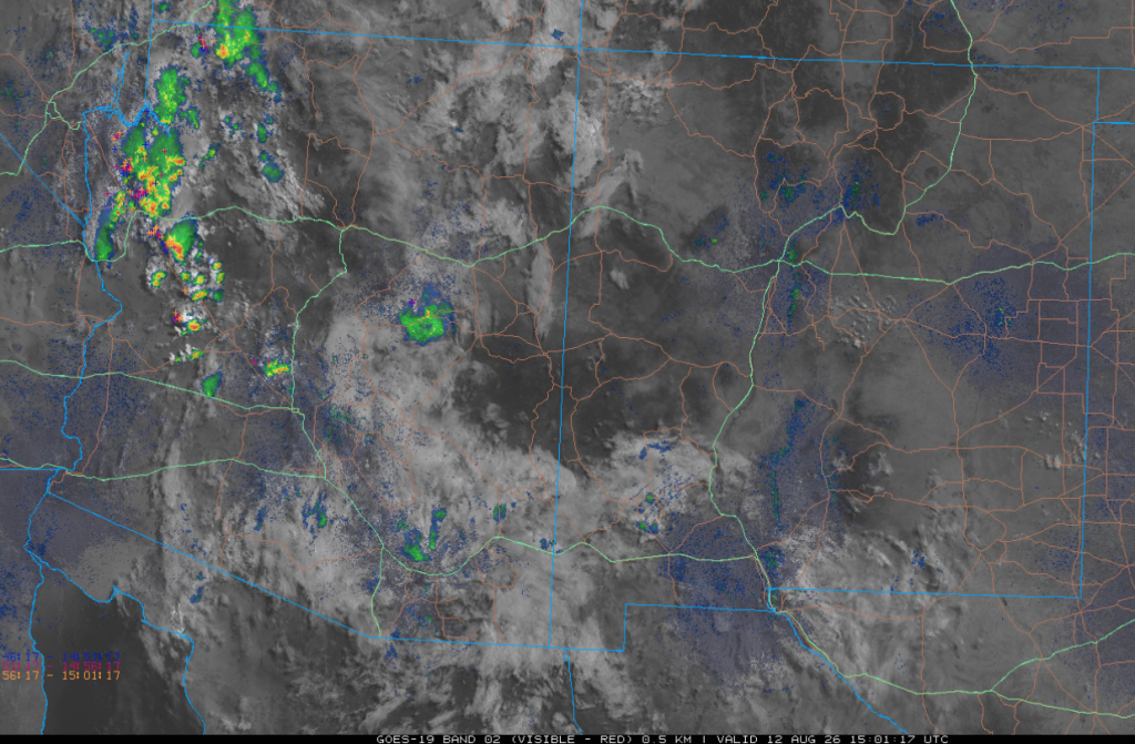
The 8 am visible satellite imagery overlaid with radar and lightning data shows remnant activity in northwest Arizona, with some showers in the cloud field extending from northwest to southeast Arizona. The storms in northwest Arizona are in a convergence zone between the monsoon ridge to the east and a trough off the west coast. Only small amounts of Convective Available Potential Energy (CAPE) are needed for the storms to develop in this area.
Above 50°F dewpoint temperatures cover the AZ/NM region, with only a small area in western New Mexico having slightly lower dewpoint temperatures. Monsoon moisture from the Gulf of California is still moving into western Arizona and eastern California due to convergence ahead of the West Coast trough.

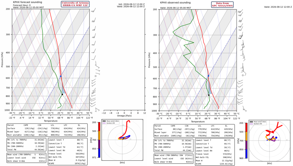
Except for some minor differences in the moisture profile below 780mb, both the model initialization (left) and observed SkewT (right) have 44 mm (1.7”) precipitable water values. This “tropical” atmosphere will not require as much heat to get thunderstorms to form.
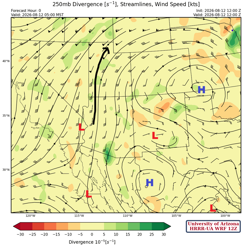
At 250 mb, the monsoon high pressure has split between a center in the Oklahoma Panhandle and another in Mexico south of El Paso. The two TUTT lows over Baja and the CA/AZ border are moving north in advance of the trough and have one or two more days providing upper-level support for storms before dissipating.
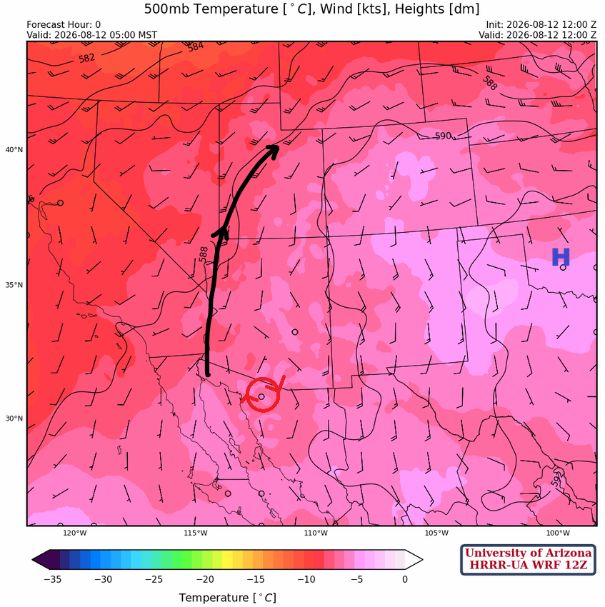
At 500 mb, the monsoon ridge has been displaced east into Oklahoma, with a convergence zone in western Arizona (black arrow). The flow is more from the south than the easterlies of yesterday. A mesoscale convective vortex associated with last night’s storms is in Mexico south of Lukeville.
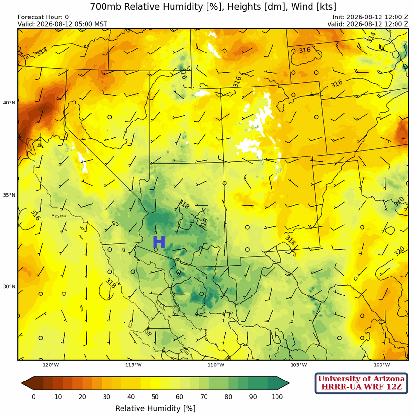
The monsoon ridge has weakened at 700 mb, but lots of moisture is available. With the combination of afternoon heating and positive vorticity advection convergence, more widespread slow-moving thunderstorms will form, especially in northern Arizona, where the NWS has issued a flash flood watch.
Today
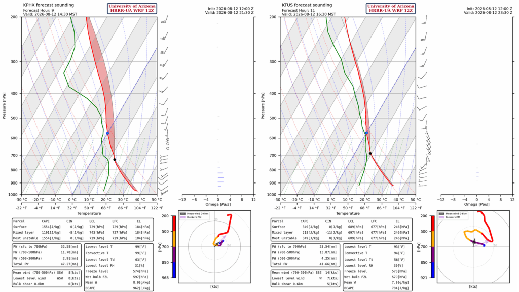
In the Mogollon Rim and northwest Arizona, training of thunderstorms is possible due to weak mean winds from 0- 6 km, and there is a threat of flash flooding. Phoenix is on the edge of the synoptic enhancement of vertical lift from the West Coast trough, and the stronger storms will remain to its north. Both the Phoenix (left) and Tucson forecast soundings (right) for this afternoon show it will not take much heat for thunderstorms today, though they look to be unorganized single-cell systems.
The 12Z HRRR-UA WRF radar reflectivity forecast shows most of the thunderstorms today will be in northern Arizona and northwest New Mexico. The clouds this morning will limit thunderstorms in southern Arizona today, but some storms will form overnight from Phoenix to Tucson as the convergence area of the trough and monsoon ridge moves east.
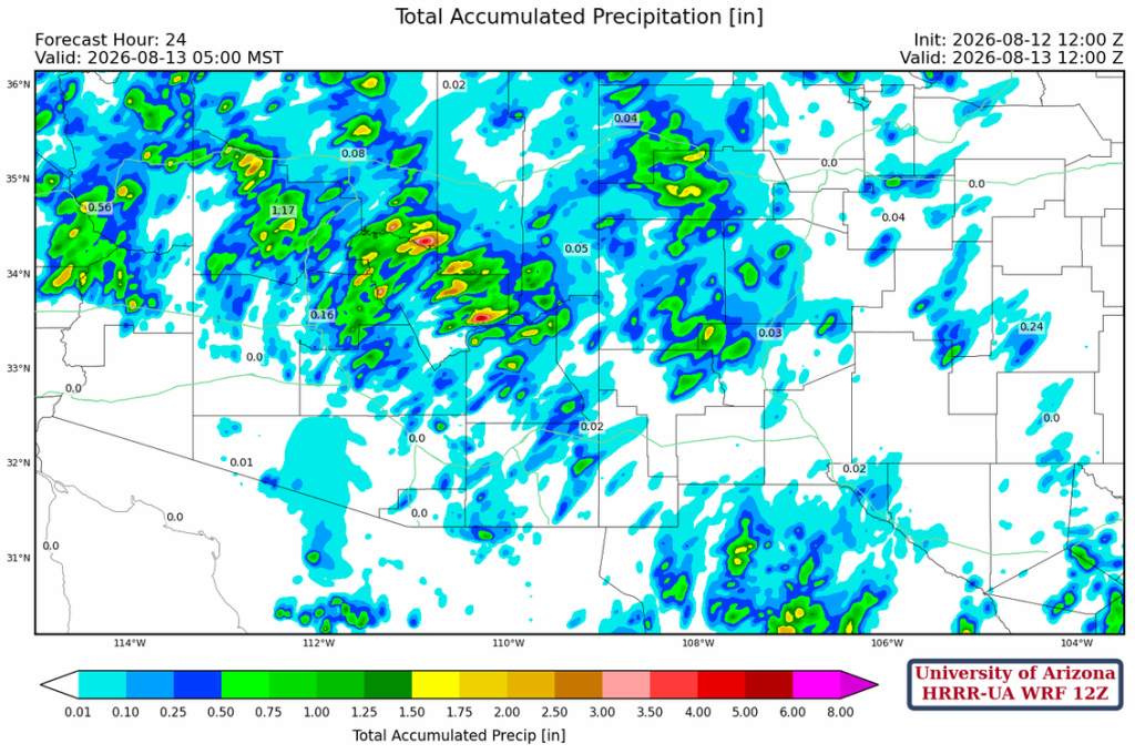
The 12Z HRRR-UA WRF 24-hour precipitation forecast through to 5 am Thursday shows the heaviest precipitation in the northern half of Arizona. The heaviest precipitation is on the Mogollon Rim northeast of Phoenix: >1.5” on the peaks, and >0.5” in the foothills.
Tomorrow
The moisture axis shifts eastward, and storms will be concentrated in southeast Arizona, including Tucson. Precipitation totals will be up to 0.75” in the valleys and up to 1.5” on the mountains. These are probably optimistic, and we’ll need to see if these totals are consistent in tomorrow’s forecast.
Outlook
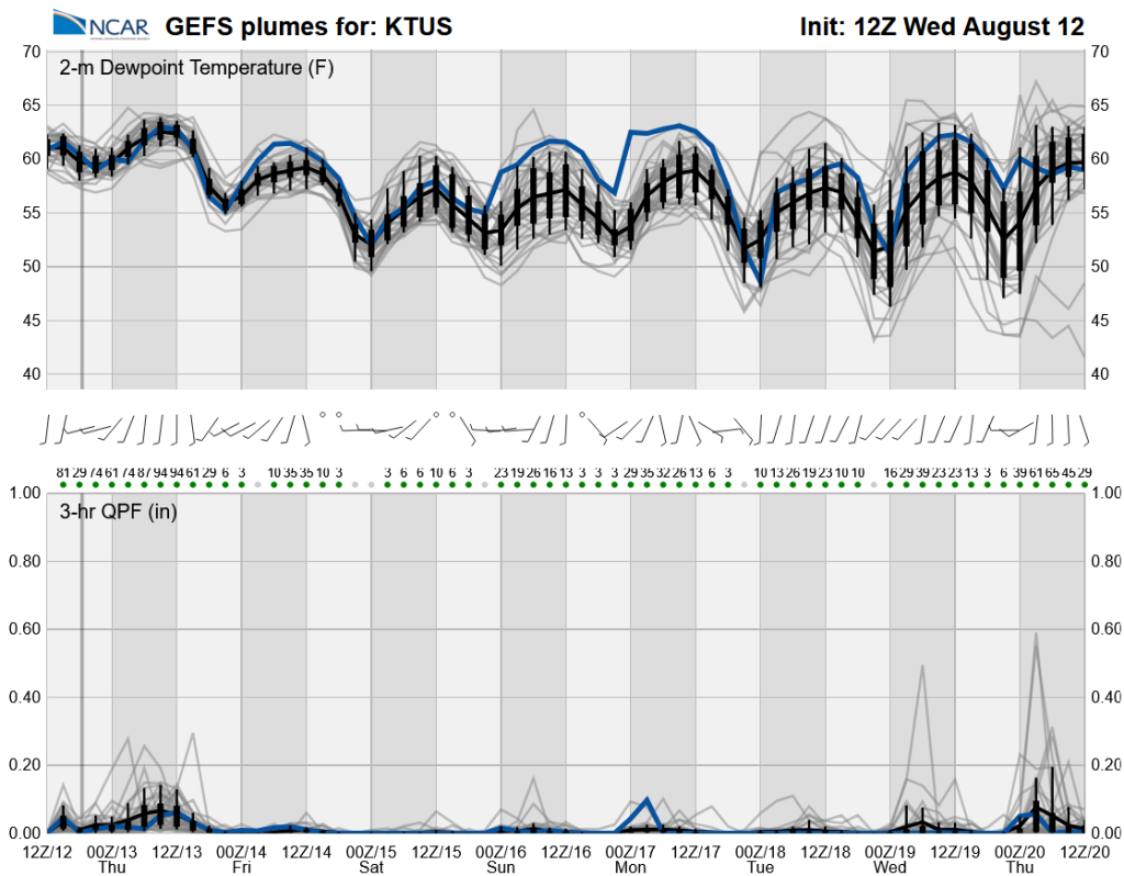
After tomorrow’s storms, monsoon moisture will be pushed out of Arizona from Friday through next Wednesday. It’s not necessarily the end of the monsoon, though, as moisture returns for the last part of August.
Discussion written by Pat Holbrook and Patrick Bunn