

Summary
The large polar trough and its associated jet stream have moved south in the Pacific, and a Tropical Upper Tropospheric Trough (TUTT) is shifting toward western Texas and New Mexico. Satellite imagery shows cloud cover over New Mexico and clear skies in Arizona, while regional moisture remains low, with only a few stations reporting higher dew points.
Overnight, outflow from New Mexico storms reached southeast Arizona, but only at the mid-levels. Warm air aloft is limiting the vertical thunderstorm extent, though some mid-level storms may form given the outflow moisture transport, mainly in eastern Pima County and the White Mountains, bringing strong winds but little rain.
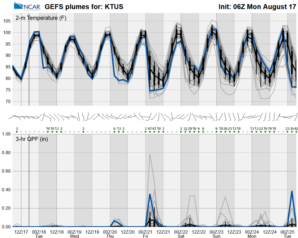
The monsoon ridge is re-forming and will gradually shift northeast, bringing more easterly flow to southern Arizona. On Tuesday, thunderstorm chances will stay limited, with activity mainly along the Mogollon Rim and the international border. By Wednesday evening, isolated storms are forecast in Pima County. Monsoon activity is expected to increase again starting Thursday into next week, with daily low temperature variability depending on thunderstorm cooling effects; expect extreme heat until then.
Yesterday’s Weather
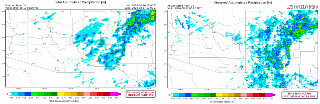
Radar reflectivity from yesterday (forecast left, observation right) shows most of the storms were in New Mexico. Arizona had isolated storms mainly in the mountains along the Mogollon Rim.
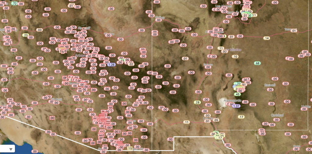
Rainlog data shows the paucity of observed rainfall in Arizona. New Mexico precipitation was mainly in the mountains, with El Paso receiving storms moving off the mountains and into the valleys.
The HRRR-UA WRF 12Z 24-hour accumulated precipitation forecast (left) and corresponding observed precipitation from MRMS (right) are shown below. Forecast precipitation was in fair agreement with observed precipitation except in far northeast New Mexico, where some of the rainfall pattern and intensity were missed.
Analysis
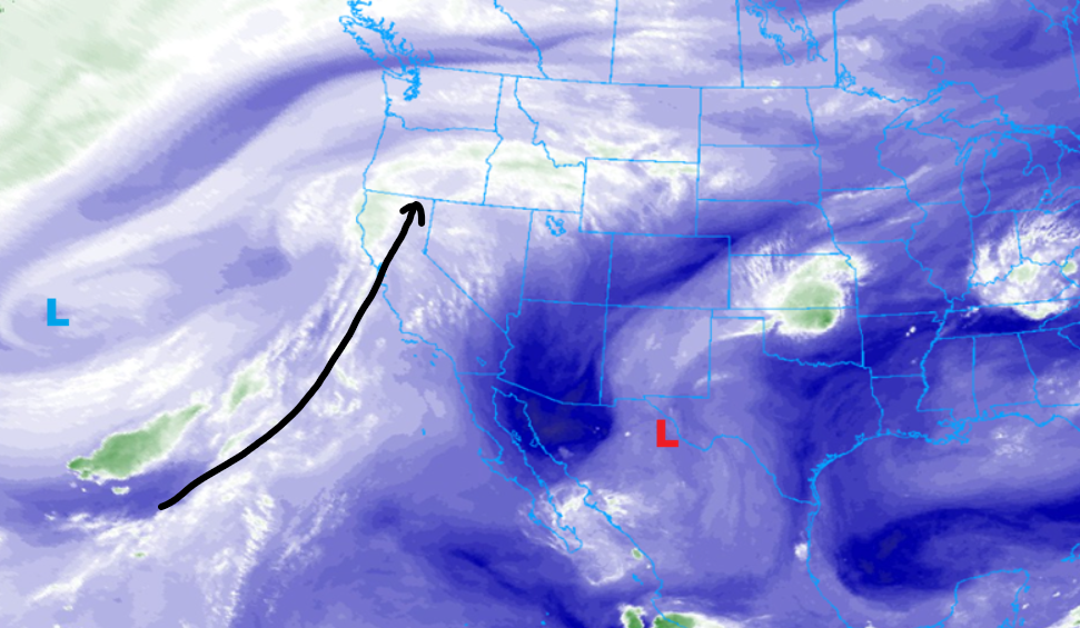
A large trough and the associated jet stream have dropped south in the Pacific Ocean well off the coast of California. A Tropical Upper Tropospheric Trough (TUTT), near Big Bend yesterday, is now southeast of El Paso and still moving slowly northwest.
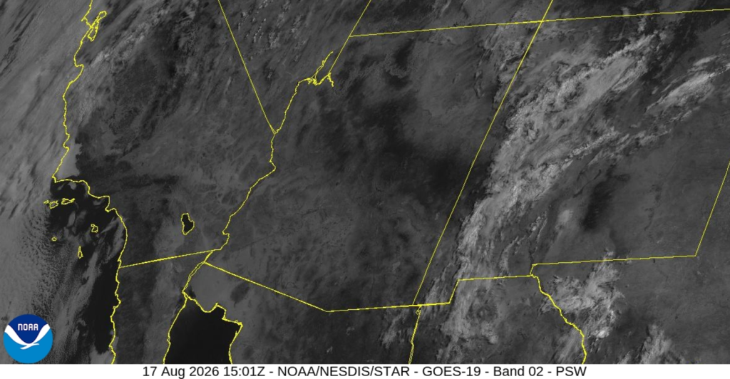
The visible satellite imagery from 8 am this morning shows clouds over New Mexico and nearly clear skies in Arizona.
Moisture is very low over the AZ/NM region, as only a few stations have 60°F dew point temperatures. Outflow from storms in New Mexico pushed into southeast Arizona overnight, although it must have been at mid-levels, as no surface reflection is seen. The mid-level outflow was visible on infrared satellite pictures yesterday, and it reached as far west as Tucson (not shown).

The HRRR-UA WRF 12Z initialization (left) and observed (right) sounding for Phoenix at 5 am show warmer air between 400 mb and 500 mb. Any thunderstorm development will be slowed by warm air at this level.

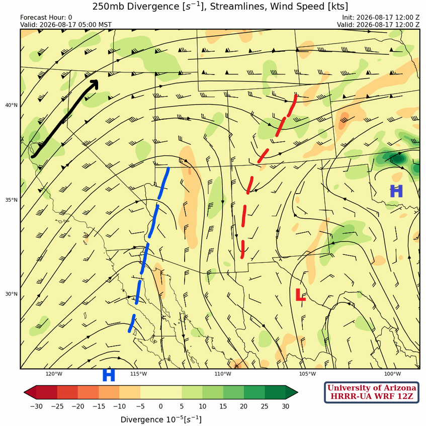
At 250mb, the monsoon ridge is in southern Mississippi and Alabama with a smaller center in Oklahoma. The TUTT is further northwest than the forecast initialization indicates, and it is interacting with the trough northwest of it in western New Mexico. Another ridge is in the Pacific Ocean southwest of the spur of the Baja Peninsula. The two ridges will combine to form a new center over northern Arizona.
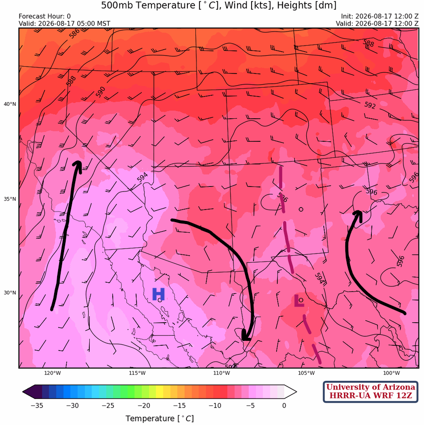
At 500mb, the monsoon ridge is in the northern Gulf of California and another center in Mississippi, with a trough between the two ridges. Through the week, the monsoon high will move northeast to just south of the Four Corners. Flow in southern Arizona will become more easterly.
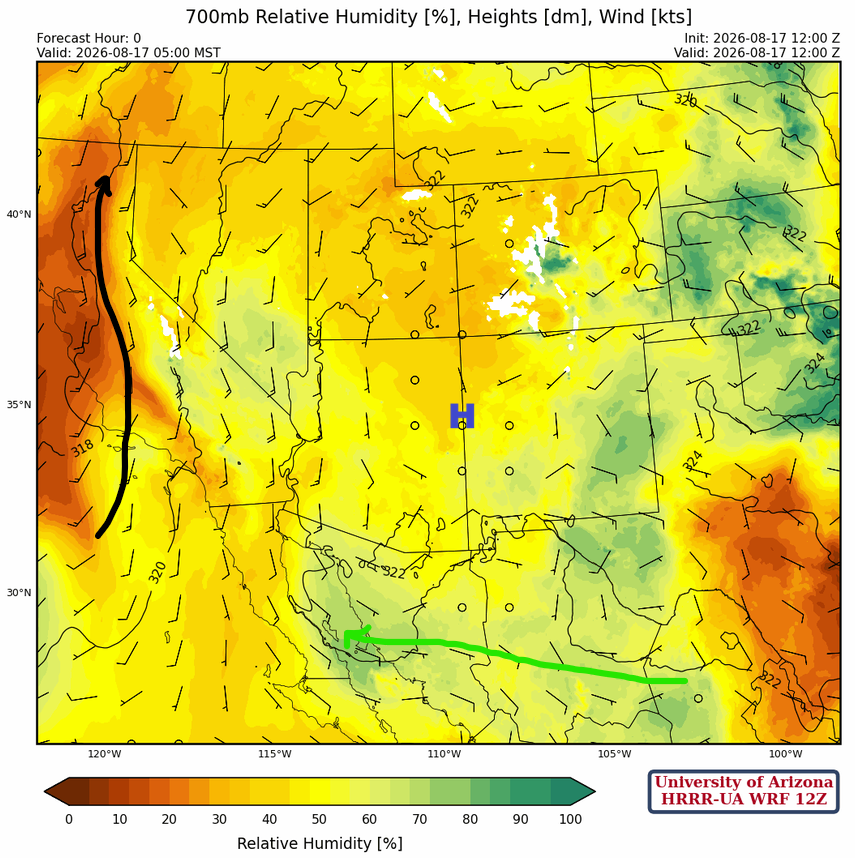
The monsoon high is trying to reestablish itself near the White Mountains at 700 mb. The only significant amount of moisture is over the eastern portion of New Mexico.
Today
Moisture from last night’s outflow has produced a more favorable environment for mid-level thunderstorm development, though there’s only a slight chance of storms given the forecast soundings for Tucson (left) and San Simon (right) this afternoon.

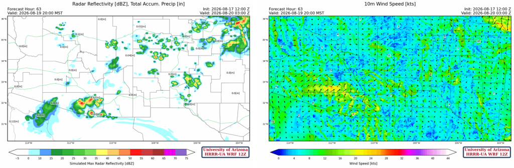
The HRRR-UA WRF 12Z forecast animation below shows thunderstorms developing in the White Mountains and sweeping southwest on strong outflow winds. Thunderstorm winds in the Safford Valley will be over 50mph. Other storms that develop will also have winds over 40 mph, and a few will be in eastern Pima County, including Tucson. These are very high-based thunderstorms, so any precipitation will be light.
Tomorrow
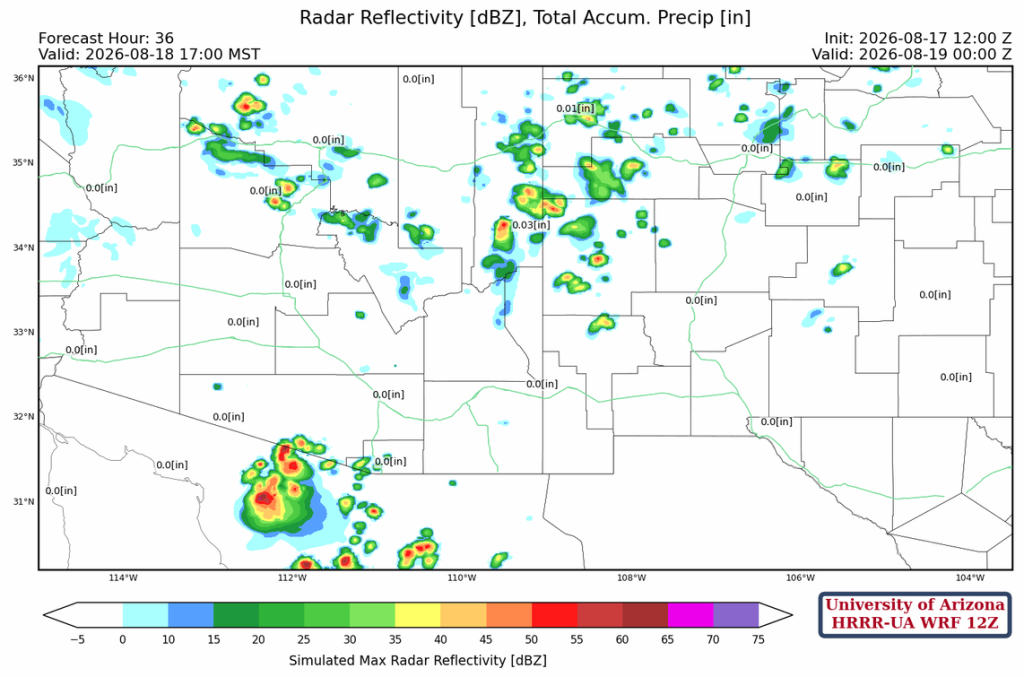
Tomorrow, thunderstorms will be mostly in the Mogollon Rim and south along the international border. Otherwise, a quieter day.
Outlook
Wednesday is similar to Monday, with hot surface temperatures and just enough moisture to support thunderstorm development. The strongest storms will be in Pima County during the evening hours, but heavy rain is not expected, and wind gusts will be less than 40mph.
Long-range global model forecasts show monsoon activity ramping back up starting Thursday into next week. The variability in low temperatures depends on whether a thunderstorm cools the atmosphere.
Discussion written by Pat Holbrook and Patrick Bunn