

Summary
Satellite imagery from this morning shows clouds and showers moving southwest, with remnant thunderstorm activity from yesterday in Mexico weakening over the Gulf of California. Although surface moisture remains limited, high-based thunderstorms are expected in southeast Arizona. A Gulf Surge may bring increased moisture tonight, but its extent east remains uncertain.
Forecasts suggest scattered thunderstorms will develop in eastern and southern Arizona today, with the potential for more widespread severe storms tomorrow. Tomorrow there’s a possibility of strong outflows, heavy rain, high winds, hail in southern Arizona, and blowing dust in Tucson that could reach Phoenix. Looking ahead, the increased moisture from the Gulf of California should bring a return to a more active monsoon pattern next week.
Yesterday’s Weather
Yesterday, thunderstorms developed and moved southward in New Mexico and Arizona. Additional storms developed along the spine of the Sierra Madre mountains south of Hermosillo and moved west to the Gulf of California. Wind gusts over 50 mph were recorded at several locations, including Safford and Lordsburg, with dust storm warnings in southern New Mexico and southeast Arizona. A haboob was spotted west of Lordsburg near Interstate 10. A feature of the storms was 1.5-inch hail at a couple of locations in New Mexico due to cold air at 500 mb around –7°C. The cold air will be moving into southeast Arizona Sunday and Monday, bringing a risk of hail with the thunderstorms.
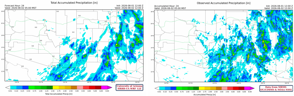
The HRRR-UA WRF 12Z 24-hour accumulated precipitation forecast (left) and corresponding observed precipitation from MRMS (right) are shown below. The forecast was generally correct with precipitation except for northern Mexico, where the observed totals are more intense and widespread than predicted.
Analysis
The visible satellite image from this morning at 8 am shows clouds and showers moving southwest across central New Mexico and parts of Arizona. Remnant clouds from a Mesoscale Convective System (MCS) are in the Gulf of California and weakening as they move west. Outflow from the MCS reached Yuma, but like the last couple of thunderstorms, it is not very deep and still has dry westerly winds above it.
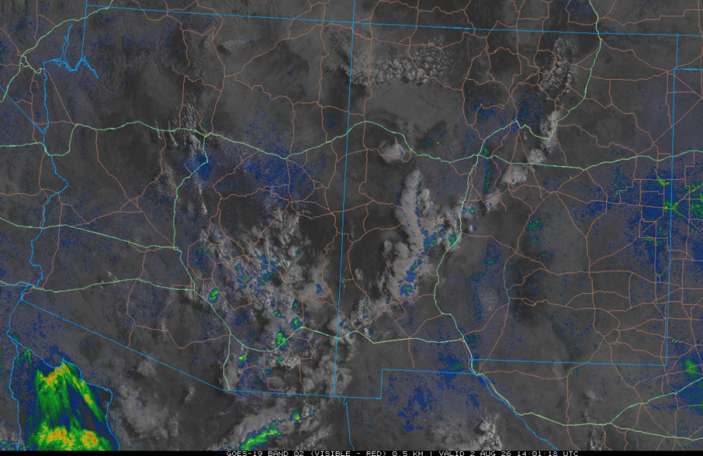
Surface moisture is still limited, which will only allow for high-based thunderstorms during the afternoon and evening in southeast Arizona. The flow is becoming more favorable for a Gulf Surge tonight, as the cold front that moved south through Texas yesterday will increase the pressure gradient in the Gulf of California tonight.

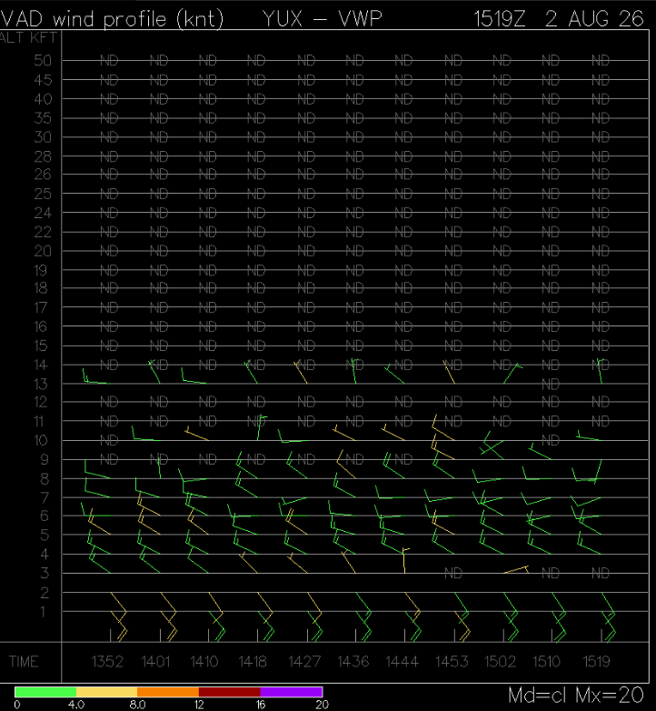
The Velocity Azimuth Display Wind Profile (VWP) from Yuma this morning shows the Gulf Surge that moved into Yuma around 8 am, with the dewpoint temperature jumping 12°F to 66°F. It’s hard to determine how far this moisture will move into the lower deserts and increase dewpoints across the rest of southern Arizona; will we have to wait until tomorrow for a stronger push?
The HRRR-UA WRF 12Z initialization (left) and observed (right) sounding for Phoenix at 5 am are similar, except the observed sounding has a little more precipitable water (37mm vs 32mm or 1.45” vs 1.2”). Another difference is that the inversion at 450mb is stronger on the observed sounding. From 450 mb down to 550 mb is where Convective Available Potential Energy (CAPE) will allow storms to form at night, similar to what happened last night and moving southwest in SE Arizona this morning.

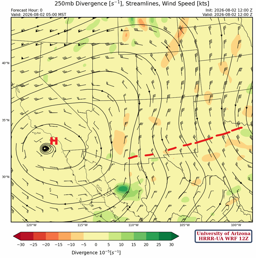
At 250mb, the monsoon high-pressure ridge has moved west off the coast from San Diego as a short-wave trough that stretches from Texas to southeast Arizona moves south.
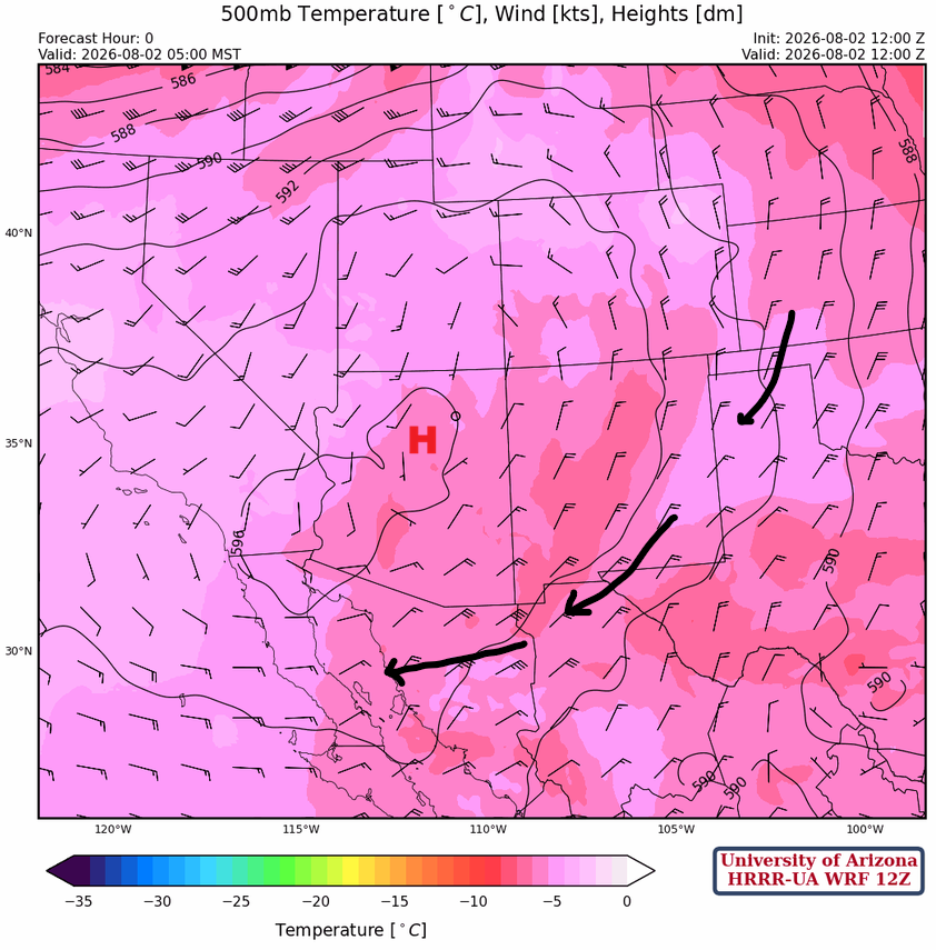
The monsoon high pressure is in northern Arizona, and the winds aloft are more from the northeast at 500 mb. Significant cooling has occurred over New Mexico and Arizona, making the atmosphere more unstable.
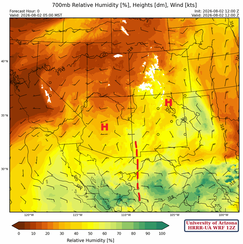
At 700mb the monsoon ridge has two centers; one near Phoenix and the other in northeast New Mexico. An easterly wave from southwest New Mexico south into Mexico is moving westward and will be the focal point for development of a Mesoscale Convective Complex (MCC) in northwest Mexico today.
Today
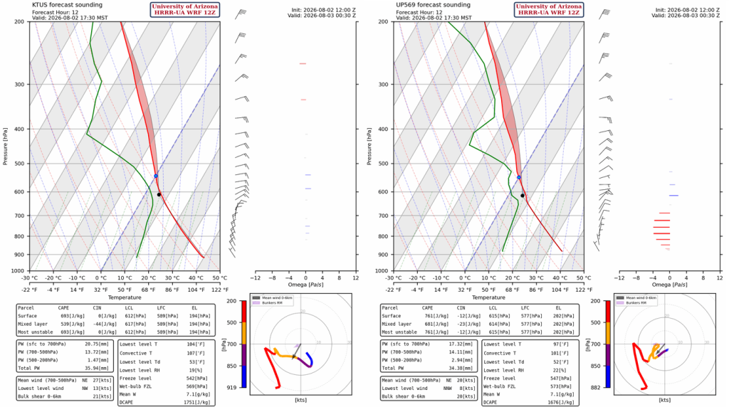
The forecast soundings for Tucson (below, left) and San Simon (below, right) indicate that thunderstorms will form in eastern Arizona similarly to yesterday, but with a more westward propagation. As outflows move into Tucson, scattered thunderstorms will develop during the evening hours. It is still very dry on the surface, so thunderstorms will be restricted to the mountains unless Gulf Surge moisture arrives later in the day.
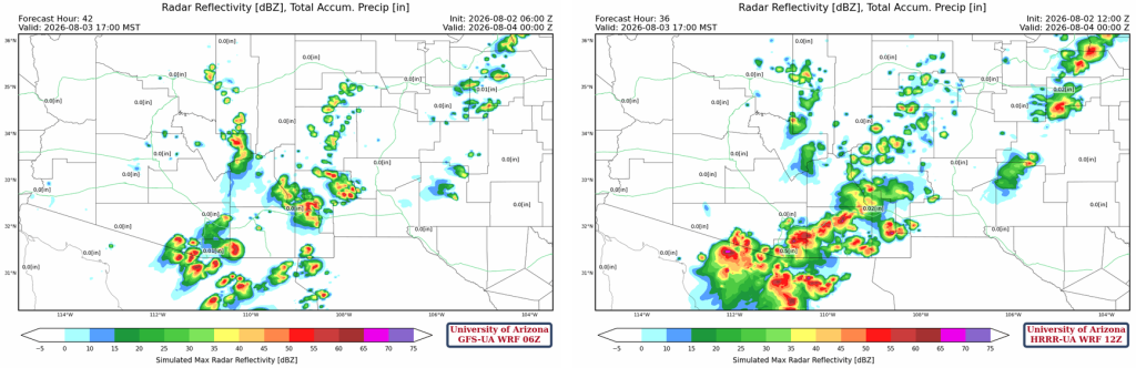
The 12Z HRRR-UA WRF and the 06Z GFS-UA WRF forecasts for this afternoon are below. There is quite a difference between the two forecasts at 9 pm tonight. The variable is how much Gulf Surge moisture moves into Arizona this afternoon and whether it will be available in time to aid evening thunderstorm development. Right now, we’re leaning towards the 12Z HRRR-UA WRF, since the Velocity Azimuth Display Wind Profile (VWP) at Yuma is not showing deep enough surge winds and there are still westerlies above 3000 feet (900m).
Tomorrow
The 12Z HRRR-UA WRF and the 06Z GFS-UA WRF forecasts for tomorrow at 5 pm are below. The forecasts are in more agreement than for today, meaning there’s more confidence that tomorrow will produce more widespread severe thunderstorms across southern Arizona.
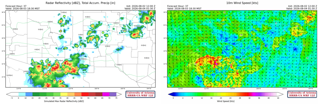
By 6:30 pm, the 12Z HRRR-UA WRF forecasts strong and possibly severe storms moving northwest along a strong outflow. There is potential for locally heavy rain, high winds, and hail. The forecast shows the storms weakening as they approach Phoenix, but blowing dust is likely to reach Phoenix along with some lighter rainfall.
Outlook
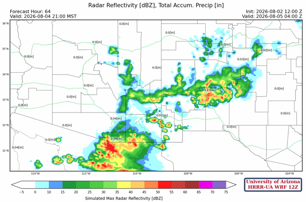
The forecast has storms developing further east than Monday, perhaps a reflection of an up day/down day situation, as storms do not want to move into the low deserts. Nogales is predicted to receive about 2.5″ of rain through to Wednesday morning; we need to see if this persists into tomorrow’s forecasts.
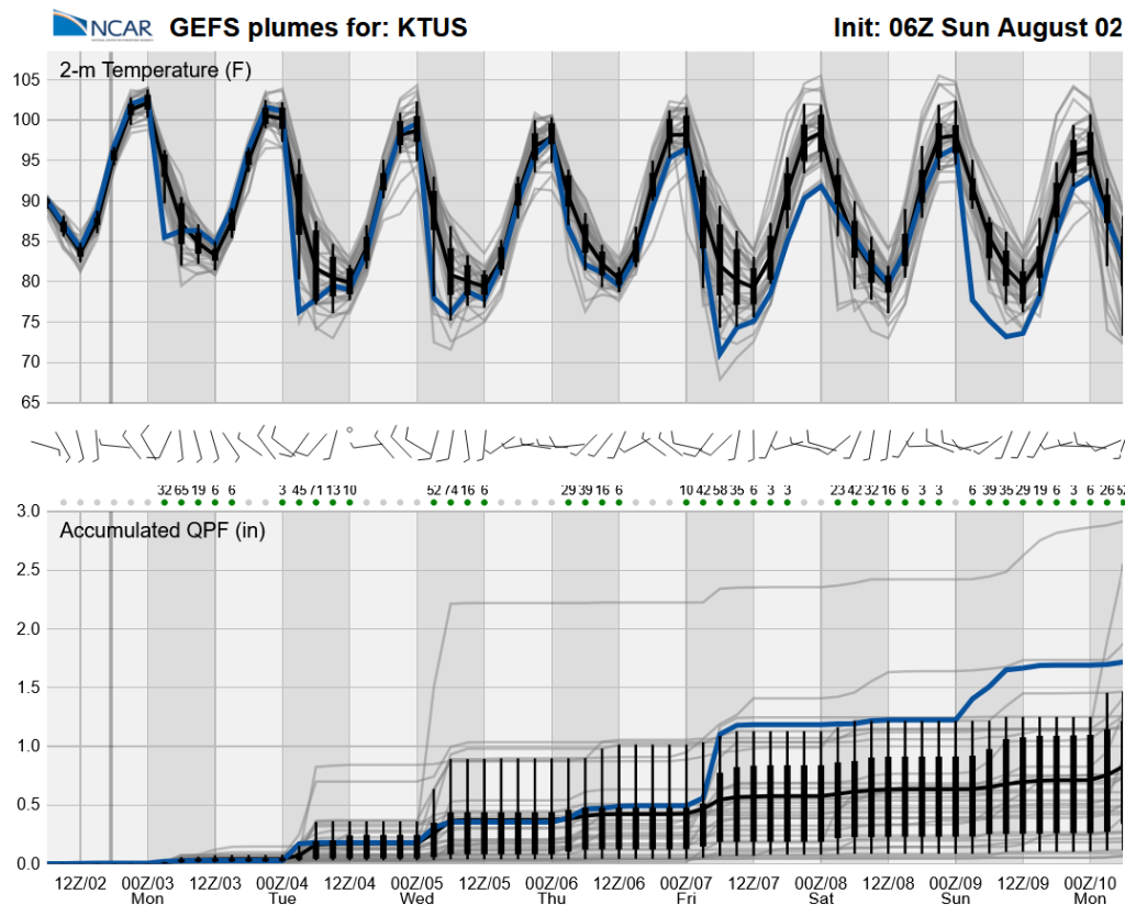
Long-range global model ensemble forecasts show we’re moving back to a more active pattern thanks to increased moisture from the Gulf of California. More typical monsoon activity is expected next week with day-to-day variability.
Discussion written by Pat Holbrook and Patrick Bunn