

Summary
A significant drop in surface dewpoint temperatures has occurred across Arizona, except in areas cooled by recent rainfall. Last night, there was no outflow from the MCS in northern Mexico to reinforce moisture in Arizona. Upper-level analysis shows the monsoon high-pressure system has shifted southeast into Texas, with an upper-level trough over California and Nevada pushing the high eastward. Two easterly waves are present over northern Mexico, influencing regional storm development.
Today, Phoenix is unlikely to see storms, but the Tucson area may experience an isolated thunderstorm due to sufficient instability. The strongest storms are forecast for Cochise County, with clouds and embedded showers moving into Pima County overnight. Tomorrow, a shift to northeasterly upper-level flow will increase storm coverage in eastern Arizona. By Saturday, New Mexico will see more widespread storms and possible dust storms from Willcox to El Paso. Longer-range forecasts suggest continued hot, dry weather through to next week.
Yesterday’s Weather
Another Mesoscale Convective System (MCS) formed in Mexico yesterday evening, as shown on the infrared satellite animation. The warm temperatures and divergence aloft helped lift the clouds to temperatures reaching –80°C. Divergence aloft is important in MCC/MCS formation, as it allows strong updrafts and mesoscale processes (5-500 km) to dominate and positively feedback on each other, further enhancing the storm system. The thunderstorms moved west and dissipated near the Gulf of California. Small isolated thunderstorms developed in southeast Arizona, reaching as far west as the Tucson region. These storms were also aided by divergence aloft, but there was only limited surface moisture to draw from, meaning only one rain gauge in both Pima and Maricopa counties recorded rainfall.
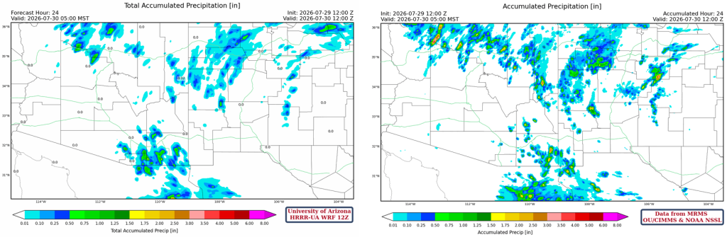
The HRRR-UA WRF 12Z 24-hour accumulated precipitation forecast (left) and corresponding observed precipitation from MRMS (right) are shown below. The forecast was in good agreement with observations.
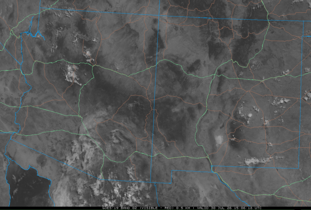
The visible satellite image from this morning at 8 am shows the remnant mid-level clouds in southern Arizona from the MCS.
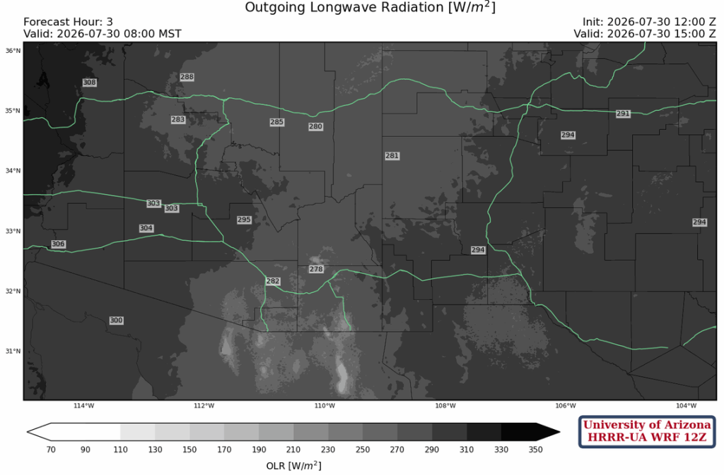
The 12Z HRRR-UA WRF model does have a decent analysis of the clouds in southern Arizona and northern Mexico.
Analysis
A big decrease in 60°F dew point temperatures across Arizona except where the rain has cooled air on the Mogollon Rim and the Grand Canyon. There wasn’t an outflow from the MCS in Mexico to Arizona last night to reinforce low-level moisture.

The 12Z HRRR-UA WRF forecast initialization is similar to the observed sounding, with only the surface irrigation systems adding some moisture. The observed near-surface dewpoints aren’t representative of the surrounding area. Either way, it’s going to be hot in Tucson today.

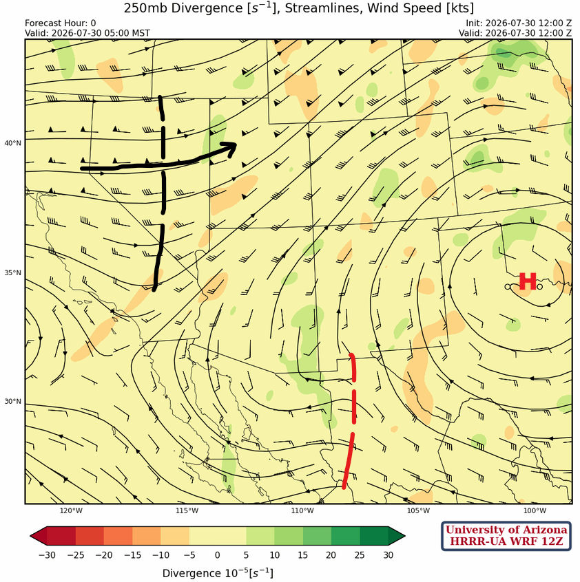
At 250 mb, the monsoon high-pressure moved southeast into north-central Texas as an upper-level trough is over California and Nevada, moving east, pushing the ridge in that direction. An easterly wave indicated in red is moving west across northern Mexico.
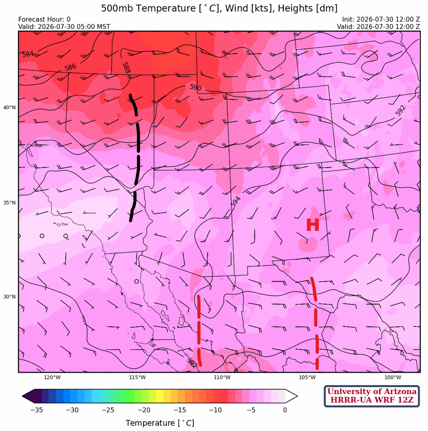
The monsoon high is in eastern New Mexico at 500mb, with the ridge axis extending to the northern Baja. Two easterly waves were analyzed at this level and will be focal points for storms in Mexico.
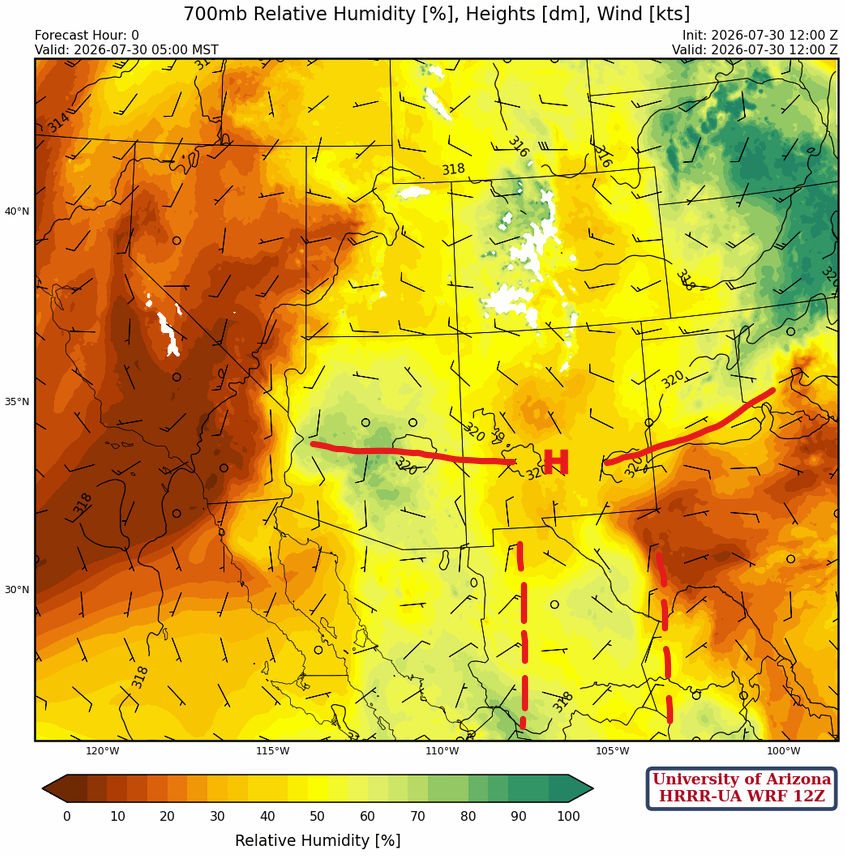
The more westward of the two easterly waves in Mexico is hard to find at 700mb, as the MCS is disturbing the wind field at this level. The 500 mb location is more accurate for the easterly wave location. There are mostly light winds at this level with the ridge axis cutting across AZ/NM. At 700mb, there are multiple centers of the subtropical high-pressure (monsoon ridge).
Today
The forecast sounding for Phoenix at 5 pm (left) cannot support storms today. Forecasts for Tucson (right), on the other hand, can make storms like the single cell south of the airport yesterday. The most unstable layer of Convective Available Potential Energy (287 [J/kg]) will initiate a few storms, even in the valleys.

Thunderstorms develop on the mountains after 3 pm, and stronger storms develop in Cochise County this evening under the influence of another MCS in Mexico. The heaviest precipitation will be along the international border in Santa Cruz and Cochise County. Some clouds with embedded showers from the MCS will move across Pima County after midnight, as the system dissipates.
Tomorrow
The upper-level flow changes to northeastly, allowing storms to become more numerous in the White Mountains, south to the international borders as they move southwest. Storm intensity will decrease, but clouds and light rain showers will continue overnight, extending as far west as southeast Pinal County. If a MCS forms in Mexico again, it will be further south and not affect Arizona.
Outlook
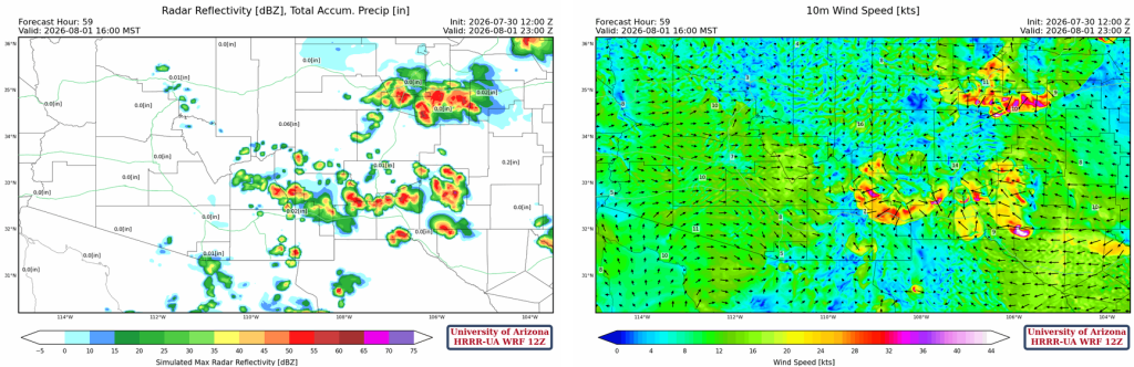
On Saturday, the thunderstorms in New Mexico increase in both areal coverage and intensity, but probably not enough to form an MCS. Dust storms are likely from Willcox east to El Paso on Saturday with the line of storms that propagate south.
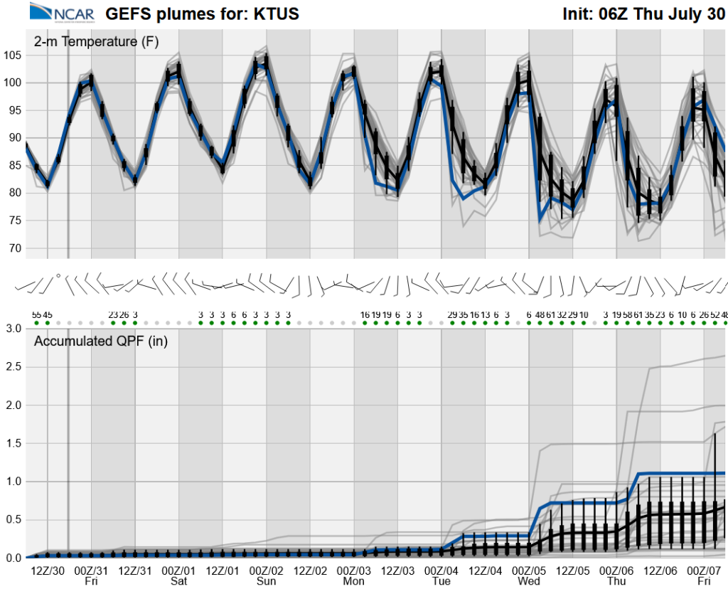
The long-range global model ensemble forecasts will keep us dry and hot until next week. The increase in moisture will likely come from a Gulf Surge due to tropical activity near the tip of the Baja Peninsula.
Discussion written by Pat Holbrook and Patrick Bunn