

Summary
An elongated trough continues to bring cooler mid-level temperatures and instability aloft from the east into the two-state region, while the sub-tropical monsoon high-pressure remains centered over Southern California. Monsoonal moisture is surging from the Gulf of California each night, bringing elevated dewpoints to southern Arizona.
Today, thunderstorms will develop later in the afternoon, especially in Graham, Greenlee, and Cochise counties, moving southwest and producing strong winds, small hail, and heavy rain mainly. Outflow boundaries will enhance storm activity in central and western Pima County and southwest Maricopa County. Overnight, more showers are expected, potentially hitting the Tucson metro, but will weaken as they move west.
The current low-grade monsoon pattern is forecast to continue into Wednesday with daily chances of thunderstorms, especially in southeastern Arizona, while Phoenix remains mostly dry.
Yesterday’s Weather
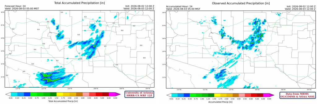
Yesterday, was a quieter day on Sunday as the back door cold front that went through New Mexico yesterday brought in dry air from the north. Most of central and eastern New Mexico had few if any storms. The dry air worked its way into southeast Arizona and parts of northern Mexico. The thunderstorms in the White Mountains and the Mogollon Rim then had difficulty moving southward into the dry air. Some storms developed near Nogales and moved southwest into Mexico before dissipating.
The HRRR-UA WRF 12Z 24-hour accumulated precipitation forecast (left) and corresponding observed precipitation from MRMS (right) are shown below. Rainfall yesterday was mainly in the Mogollon Rim and White Mountains and near Nogales. The forecast looks pretty good with minor differences resulting from the dry air not allowing storms to move from the White Mountains to Nogales. The other slight forecast miss is the early morning storms in a narrow band from Casa Grande east into western Graham County.
Analysis
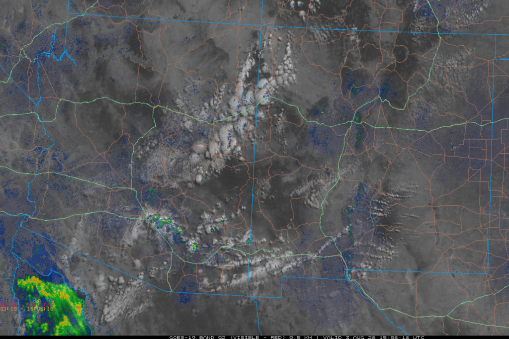
The visible satellite image from 8 am combined with radar and lightning data is below. Some mid-level-based showers and thunderstorms extend from Casa Grande to the mountains north of Tucson. These storms should dissipate by early afternoon. The radar reflections in the northern Gulf of California are caused by ducting (trapping under an inversion) of the radar beam due to the ongoing Gulf Surge of moisture north/northeast into Arizona.
New Mexico is dry with 40°F dewpoint temperatures across most of Arizona. Arizona is dry to the north, but the southern half of the state has elevated dewpoints to the south and west. The Gulf Surge has brought 70°F dewpoint temperatures into southwest Arizona.

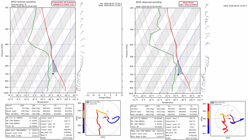
There is a little more moisture on the observed sounding (right) compared to the HRRR-UA WRF 12Z initialization (left), and the overall moisture has increased since yesterday by 0.2”, precipitable water is now 1.5” (39mm). The unstable layer between 550mb and 490mb is where the morning showers are located and this layer is capped by a strong inversion.
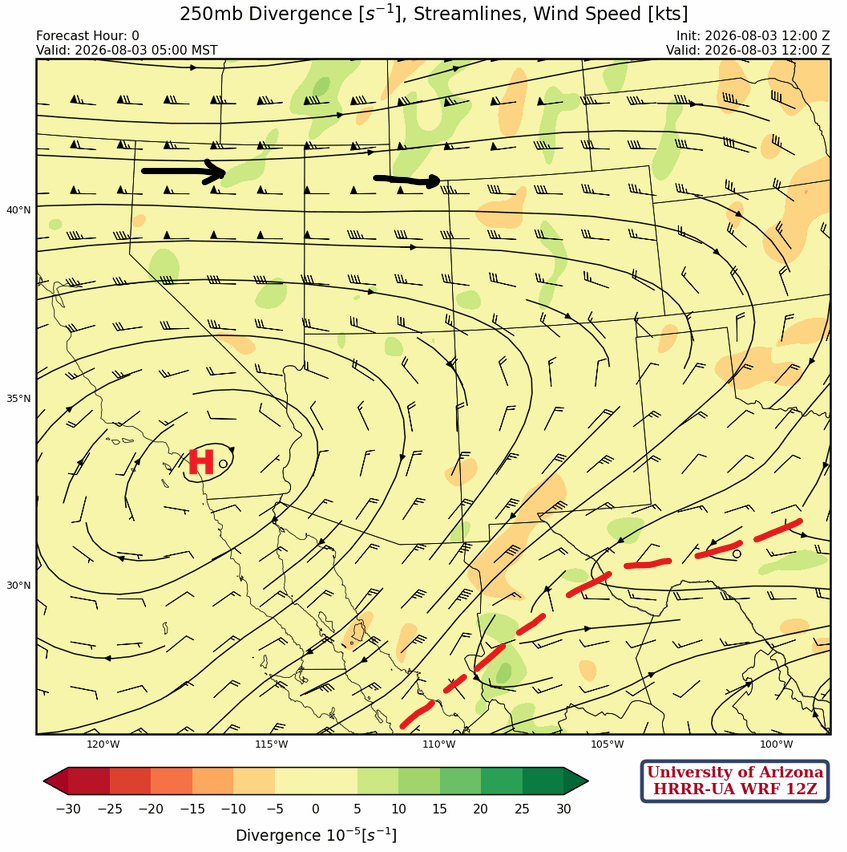
At 250mb, the monsoon high is slightly futher east today, onshore over Southern California, with the jet stream to the north. The shortwave trough has elongated and dropped further south, now extending from central Texas west to the Baja Pennisula.
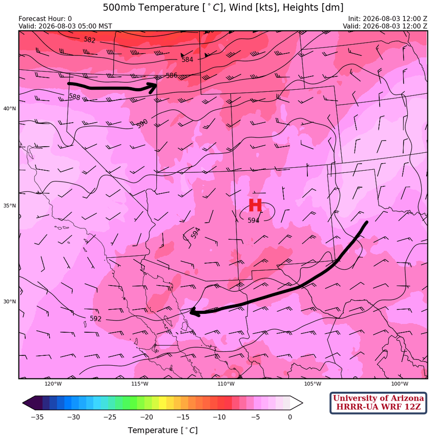
The monsoon ridge just south of the four corners at 500mb and as the trough to the north passes by today it will probably shift a little further north by tomorrow. Relatively cold air is moving underneath the ridge.
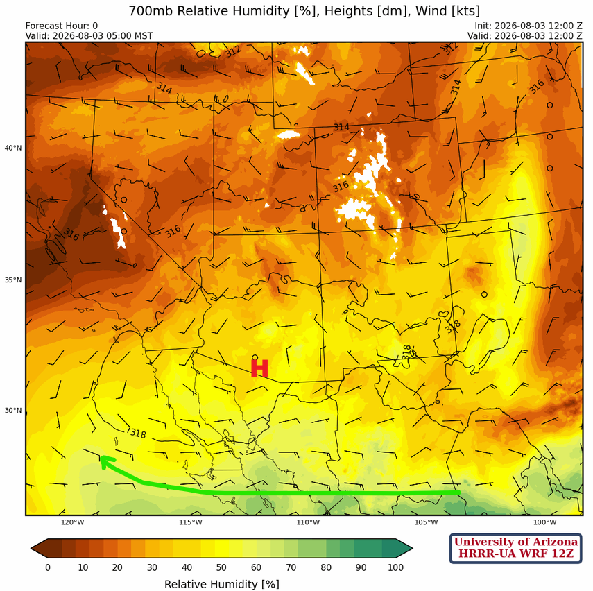
At 700mb, the monsoon ridge is in southern Arizona, about the same position as yesterday. Dry air is north of the ridge between the polar jet stream and the monsoon ridge. A moist easterly flow is in central Mexico to the Baja Peninsula.
Today
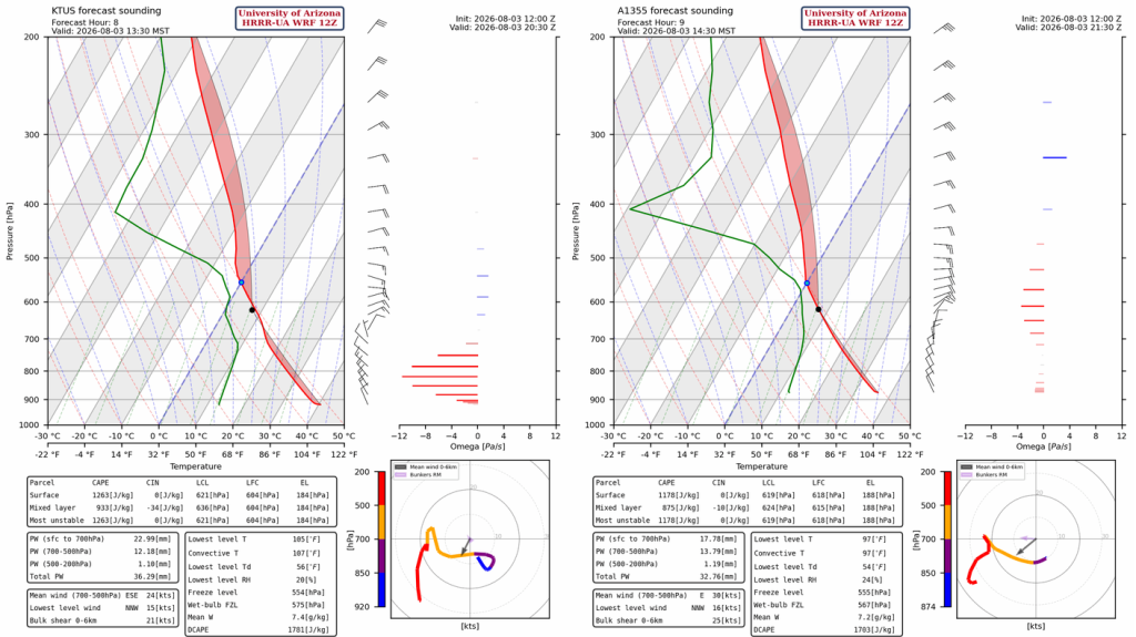
The forecast soundings for Tucson (below, left) and Nogales (below, right) indicate that thunderstorms will form in the afternoon in a high CAPE, >1700 [J/kg], environment. Mean 0-6km wind would suggest the storms will move southwest as they develop.
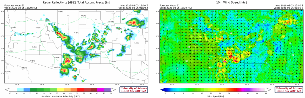
Thunderstorms are forecast to form in Graham, Greenlee, and Cochise counties in the afternoon and move southwest. Outflow winds move into the Tucson area this evening and should aid in the development of the thunderstorms in the lower deserts. Wind gusts may exceed 50 mph at some locations. Small hail and heavy rain, especially south of Tucson, is possible. The outflow boundary moves up to Phoenix and will be accompanied by wind gusts between 30 and 40 mph along with blowing dust. The issue in forecast is the ongoing Gulf Surge; additional mositure will not get into the Tucson area, but will enhance storms in central and western Pima County along with southwest Maricopa County.
Tomorrow
Some overnight showers and thunderstorms will continue across southern Arizona, but will dissipate by early afternoon. Tomorrow afternoon and evening thunderstorms will develop in about the same location as today accompanied by 40 mph wind gusts. In Tucson, weaker storms will redevelop in the wake of the initial burst after midnight, but only light rain is expected.
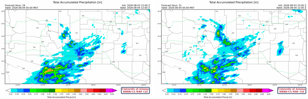
The forecast total accumulated precipitation from the 12Z HRRR-UAWRF (below, left) and 15Z UAWRF (below, right) through to 5am tomorrow morning is shown below. What stands out is the heavier precipitation south of I-10 from Vail west to Green Valley forecast by the 15Z forecast; which is probably due to colliding outflow bounadries.
Outlook
On Wednesday, moisture is still available for afternoon and evening thunderstorms. Like the previous two days, the storms form in Graham and Cochise County and move southwest. Storms form further up the Mogollon Rim and move south, but still don’t move into Phoenix.
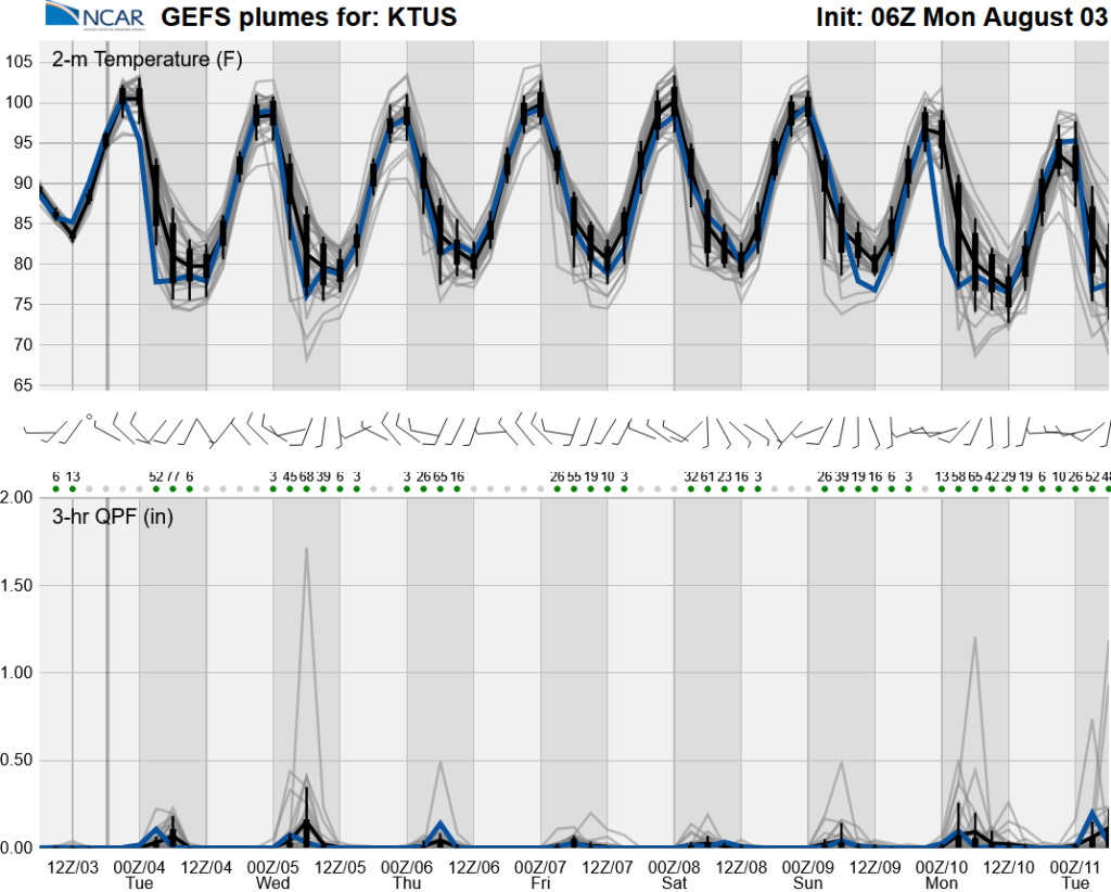
The long-range ensemble forecasts have not changed much with a low-grade monsoon most days.
Discussion written by Pat Holbrook and Patrick Bunn