

Summary
Upper-level water vapor satellite imagery shows the jet stream stretching from the Pacific to northern California, with a quasi-stationary low-pressure system off the West Coast. An upper-level low just south of El Paso is splitting the subtropical high in two. It will push an inverted trough east that will change the wind direction aloft and sweep up MCS circulations happening in northern Mexico. Surface dewpoints remain similar to yesterday morning, but a Gulf Surge of moisture is moving into southwest Arizona and northwest Mexico. Elevated moisture and favorable mid-to-upper-level flow will bring more activity to the region from tomorrow on.
Today’s soundings show inversions at the top of the boundary layer and subsidence above that, meaning isolated mountain storms today, with limited rainfall expected in the valleys. Sufficient precipitable water exists, particularly near Hermosillo, which may reinforce the Gulf Surge, with another MCS possible in northern Mexico this afternoon/evening.
Tomorrow afternoon, the increased moisture raises the likelihood of thunderstorms, strong winds, dust, and heavy rain, especially for Tucson and Pima County, and outflows will take storms to Phoenix by the evening. The monsoon pattern is expected to stay active into next week, with moisture recycling and rebuilding of the subtropical helping storm development.
Yesterday’s Weather
Thunderstorms developed, as forecast, yesterday east of the outflow boundary observed on satellite imagery on Sunday night and Monday morning. The outflow boundary brought enough mid-level moisture from storms to develop amid yesterday afternoon’s high temperatures. The thunderstorms ended soon after dark as they moved south into Mexico.
A thunderstorm complex developed along the Gulf of California. Outflow from the thunderstorms has produced a Gulf Surge that reached Puerto Peñasco this morning and may move into far southwest Arizona later today.
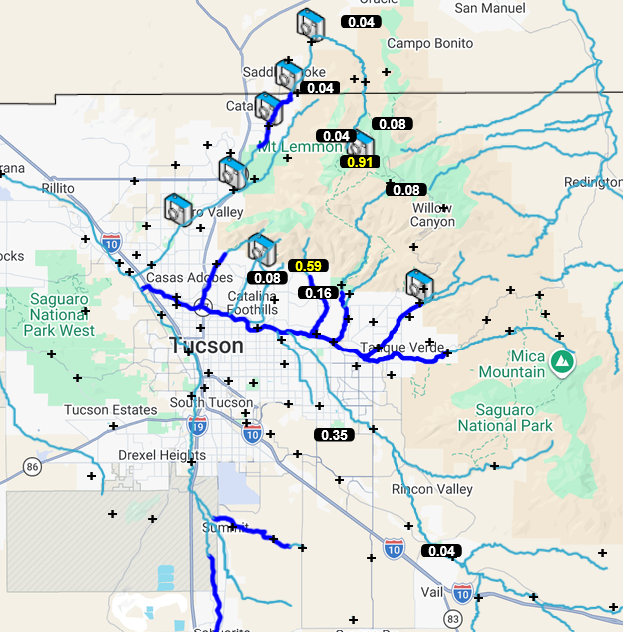
The Pima County Flood Control District rain gauge data for Monday is shown below. The minimum amount of rain in the gauge must be 0.04 inches or more; anything less is not reported on this map. There were lighter amounts of rain in the eastern half of the Tucson metro area. The core of the rain shafts were small, and the heavier rain shown below only represented a small area near the gauge (e.g., the rain gauge at Kolb and Golf Links had 0.35”, but only 0.02” fell at Pat’s house a few blocks north of that location). The small rain shafts were probably the reason the wind gusts were not too strong or widespread. A 41-mph wind gust was observed at Davis-Monthan AFB and Safford, Graham County.
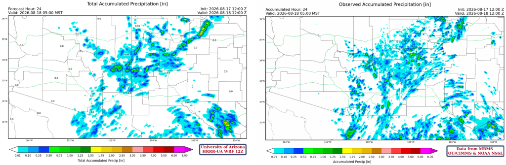
The HRRR-UA WRF 12Z 24-hour accumulated precipitation forecast (left) and corresponding observed precipitation from MRMS (right) are shown below. The heaviest rain was over the mountains: Cochise County precipitation was highest near the Chiricahua Monument and the Huachuca Mountains south of Sierra Vista, receiving 1.75″. The forecast and observed precipitation are pretty good, and the curvature south of El Paso is probably due to Tropical Upper Tropospheric Trough (TUTT) circulation centered south of the TX/MX border.
Analysis
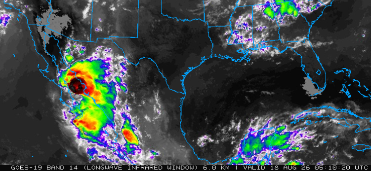
The upper-level water vapor satellite image shows the jet stream stretching from the Pacific Ocean to northern California (black arrow) and is associated with a large trough off the western coast of the United States (light blue “L”). A TUTT low is south of El Paso, and another is approaching the Mexican coast south of Brownsville (red “L”s). Finally, high pressure is in the southern Gulf of California, created by last night’s thunderstorm complex (dark blue “H”).

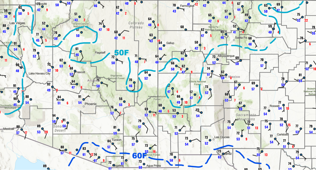
Morning surface dewpoint temperatures haven’t changed much today compared to yesterday, but we will need to keep an eye on southwest Arizona and northwest Mexico as surge moisture moves into that area. A Mesoscale Convective System (MCS) may develop in northwest Mexico this afternoon and evening, with outflow from yesterday’s MCS that will reinforce the Gulf Surge.
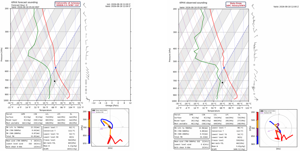
The HRRR-UA WRF 12Z initialization (left) and observed (right) sounding for Phoenix at 5 am are shown below. There are two inversions on the observed sounding; the first inversion is at 510mb and is at the top of the boundary layer, and the second at 420mb is a subsidence inversion associated with the upper-level high pressure. Both initialization and observed soundings have precipitable water values near 32 mm (1.3″).
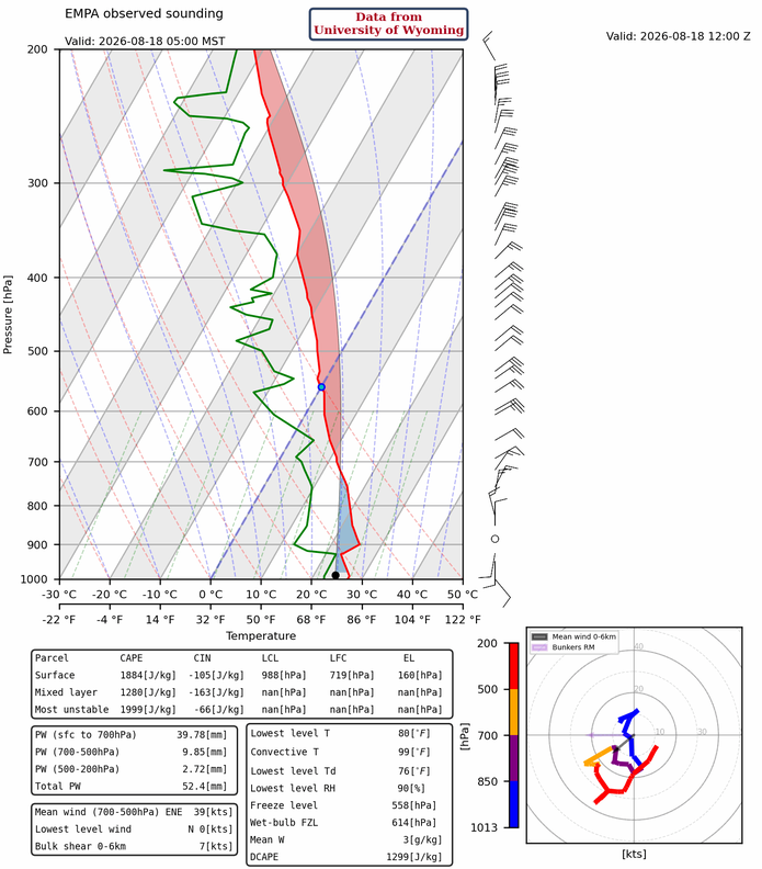
The observed sounding below is from Empalme (Guaymas), Mexico, and the inversion near 900mb is related to the Gulf Surge. Surface dewpoint temperature at Hermosillo increased about 10 degrees over 24 hours. Temperatures should easily reach convective temperatures this afternoon at Hermosillo, helping create an MCS that would reinforce the Gulf Surge.
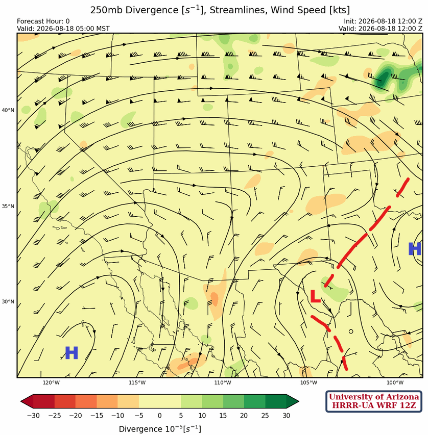
At 250mb, the TUTT low is further west (south of El Paso) than indicated by the analysis that feeds forecast initialization. The TUTT is located along the trough axis (red dash) that extends from Oklahoma southwest to the TUTT low, then southeast from there to the TUTT low south of Brownsville. This trough cuts in two the subtropical monsoon ridge reforming in Texas and the one west of the Baja Peninsula.
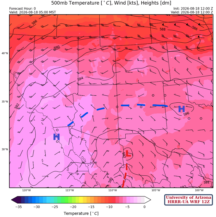
At 500mb, the monsoon ridge is trying to get back to the Four Corners, and this morning it is just south of San Diego, with another ridge center in Texas. While the ridge rebuilds over Arizona and New Mexico, the TUTT low southwest of El Paso will combine with circulation from the thunderstorm complex in Mexico last night and continue moving west. This will change the wind direction aloft in Arizona from northeasterly to easterly.
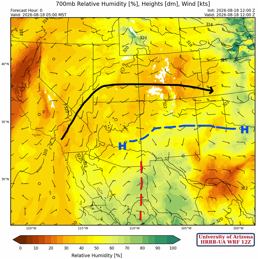
The monsoon ridge is elongated from central Arizona to north central Texas, at 700 mb. The inverted trough (red dash) will continue moving west and help initiate the MCS south of Douglas and Nogales.
Today
It’s difficult to find any Convective Available Potential Energy (CAPE) on either forecast sounding, Tucson at 3 pm (left) and Nogales at 5 pm (right). The strong inversion at the top of the boundary layer at 500 mb is limiting the CAPE, indicating isolated mountain storms are more likely, with the valleys remaining dry.

The forecast radar reflectivity for this afternoon shows only a few thunderstorms in the White Mountains and isolated from Tucson south into Mexico. No significant microbursts are expected, and any rainfall in the valleys will be light.
Tomorrow
The Gulf Surge moisture is moving into southwest Arizona today. The Tucson sounding (below, left) for Wednesday afternoon at 2 pm shows the surge of moisture has moved into Tucson. The Phoenix sounding (below, right) does not show surge moisture, but thunderstorms may form along the outflow forecast for later in the day.

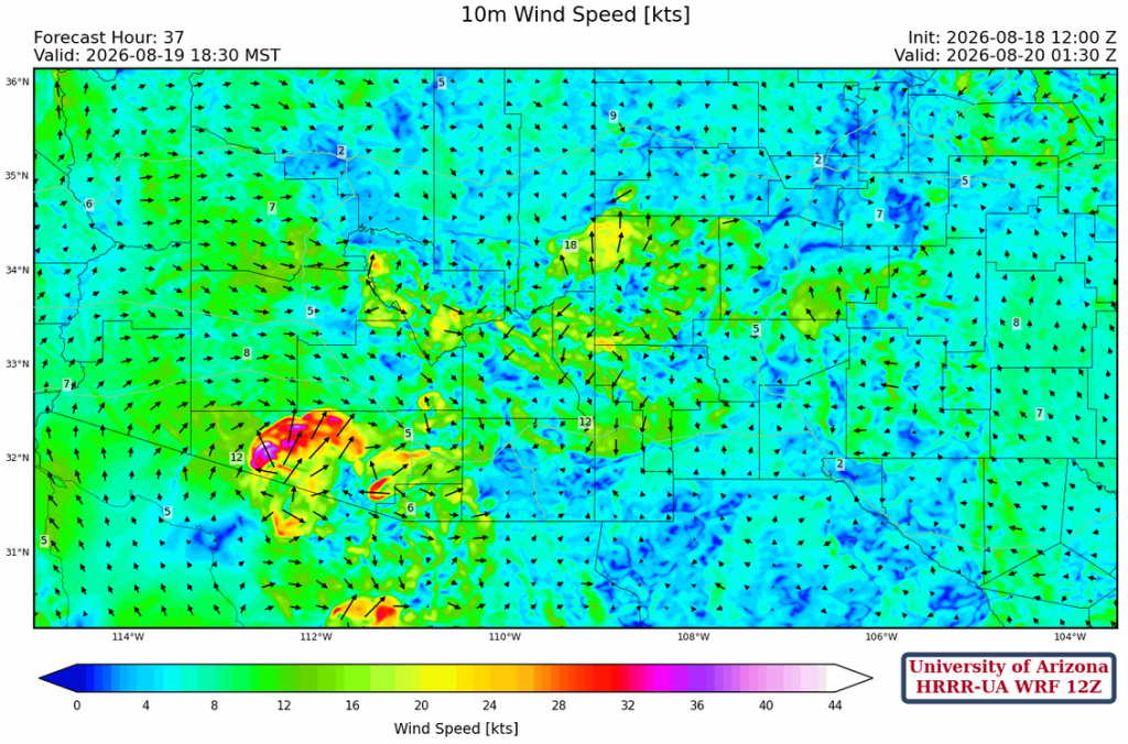
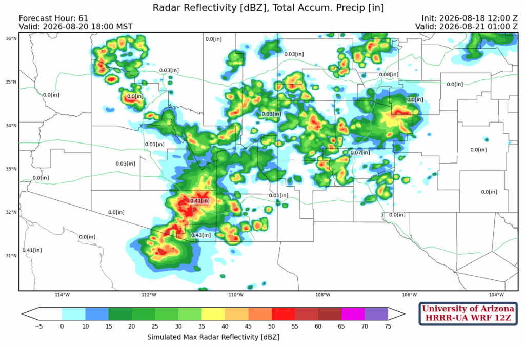
Tomorrow, thunderstorms form in the afternoon from Tucson west into central Pima County. These storms will bring high winds, blowing dust, and heavy rain, and they will arrive in Phoenix around 9 pm.
The 10-meter wind speed forecast for tomorrow at 6:30 pm shows the type of outflow that will help initiate storms in the Phoenix area after 8 pm.
Outlook
Typically it’s an up-day/down-day pattern in monsoon season for Arizona, but the forecast shows another up day for Thursday. Surface moisture from the Gulf Surge will be recycled, with surface heating and convective temperatures as the potential limiting factors.
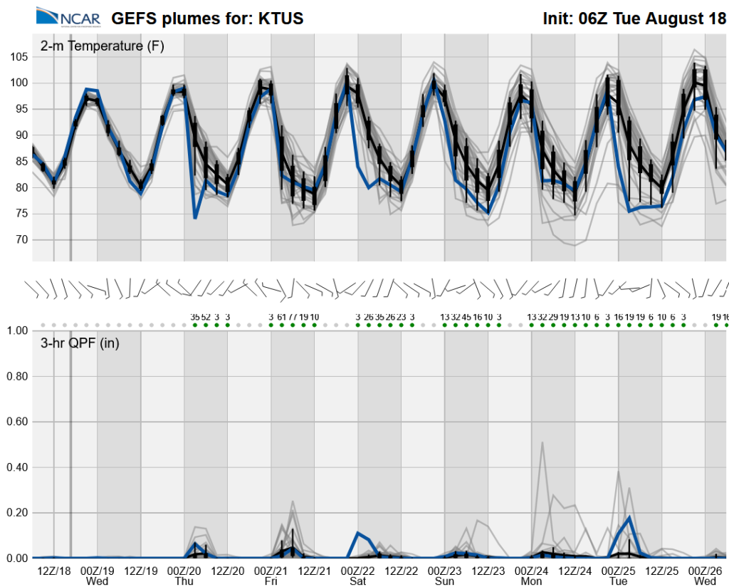
Long-range global model forecasts show we’re back to a more active monsoon pattern through to next week.
Discussion written by Pat Holbrook and Patrick Bunn