

Summary
Three Tropical Upper Tropospheric Troughs (TUTT) are moving across the region, and the monsoon ridge is shifting in response to an approaching trough from the West Coast. Satellite images show debris clouds and developing thunderstorms, especially in central and western Pima County. Surface observations indicate a decrease in moisture, but enough remains in northern Arizona for isolated storms.
Forecasts predict more isolated, less intense thunderstorms today, with limited rainfall and gusty winds, and a similar pattern continuing into tomorrow. Over the next few days, the monsoon pattern is expected to stay low-grade, although potential tropical activity in late August or early September could bring moisture back to Arizona.
Yesterday’s Weather
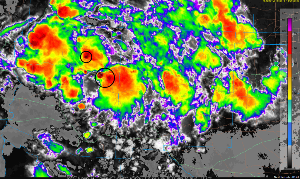
The infrared satellite image from 6:00 pm yesterday shows colors that represent cloud-top temperature (blue-green to orange-red, meaning warmer to colder), which is analogous to cloud height above the ground. The scale on the right shows the heights in feet and km, and the circled clouds had tops around 55,000 feet (18 km). Although the clouds were tall, upper-level winds spread them over a large area downwind of the thunderstorm (circled in black), making the storms appear disproportionately large given the size of their cores.
The radar reflectivity comparison below (forecast left, observation right) shows scattered storms over northern Arizona and New Mexico, with only isolated storms in southern Arizona.
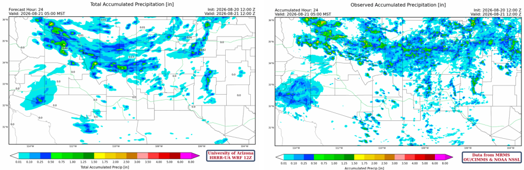
The HRRR-UA WRF 12Z 24-hour accumulated precipitation forecast (left) and corresponding observed precipitation from MRMS (right) are shown below. No precipitation fell in the Tucson or Phoenix metro area yesterday. The MRMS observations below show the precipitation that fell in the northern half of Arizona and New Mexico. The rain near Yuma was from the MCS yesterday morning. The forecast areal coverage of precipitation in northern New Mexico was underestimated, as was the rainfall from the MCS near Yuma.
Analysis
The upper-level water vapor satellite image below shows three Tropical Upper Tropospheric Trough (TUTT) lows still, but the one off the California coast is being absorbed into the jet stream. The polar low and jet stream to its east are moving slowly northward. The TUTT low in central Mexico is moving slowly west while the TUTT low near Florida is weakening as it moves southward.

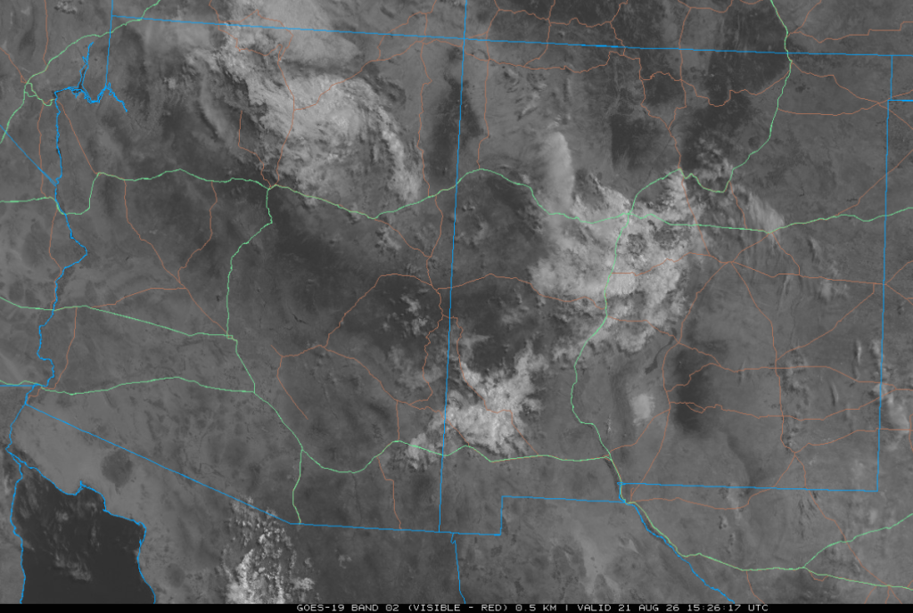
The visible satellite image shows mostly debris clouds from last night’s activity. The clouds west of Nogales are forecast to develop into thunderstorms this afternoon in central and western Pima County.
The surface dewpoints show an overall decrease in moisture content in southern Arizona as the Gulf Surge has ended. However, there is still enough moisture for now across northern Arizona to support thunderstorms again this afternoon.

The HRRR-UA WRF 12Z initialization (left) and observed (right) sounding for Phoenix at 5 am are shown below. Both the forecast initialization and observed sounding surface-based Convective Available Potential Energy values are erroneously large because of the high surface dewpoint temperature. The mixed-layer CAPE and Convective Inhibition (CIN) best represent the atmosphere, and with more drying expected today, realized CAPE values will be lower.

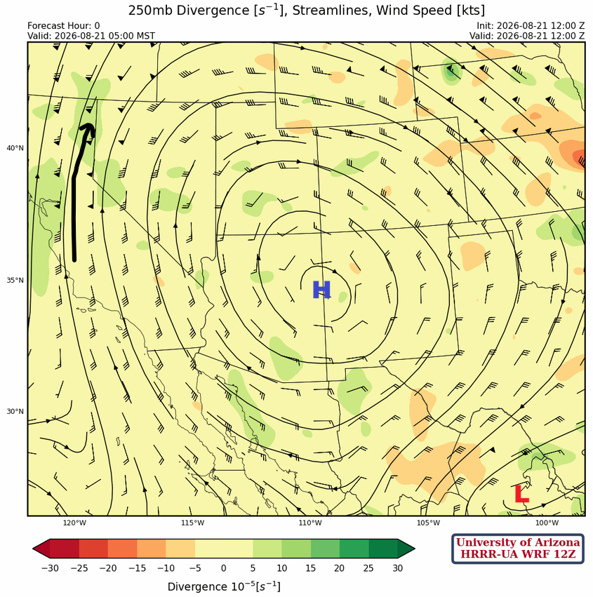
At 250mb, the monsoon high is just south of the Four Corners, and a TUTT low is in central Mexico. Major changes are in store over the next few days as the trough off the West Coast moves east and pushes the monsoon ridge into southeast New Mexico. The TUTT low will be stretched into an east-to-west trough across central Mexico.
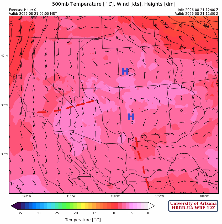
At 500mb, the monsoon ridge has two centers; one over western Colorado and the other over southwest New Mexico. A couple of shortwave troughs are rotating around the ridge. The trough in western Arizona and eastern California will continue moving north and aid in thunderstorm development in that area; the shortwave to the south in Chihuahua will continue moving west.
The monsoon ridge is over southwest Colorado at 700mb, with three shortwave troughs rotating about the ridge. The two shortwave troughs in central and eastern Mexico will be responsible for thunderstorms developing along the spine of the Sierra Madre mountains from the southern border south into Mexico. Moisture remains limited, so MCSs are not expected.

Today
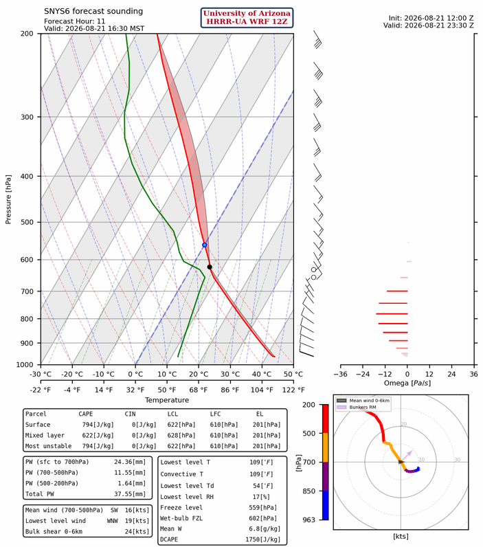
The forecast sounding below is from Lukeville, Arizona, for 4:30 pm. The skewT shows potential for thunderstorms this afternoon in central and western Pima County, with motion to the northeast. Additional development is likely moving to the north into southern Maricopa County as storms form on outflows. The Flagstaff and Springerville soundings are similar to yesterday, but with less moisture, meaning thunderstorm development across northern Arizona is likely again today, but they will be more isolated.
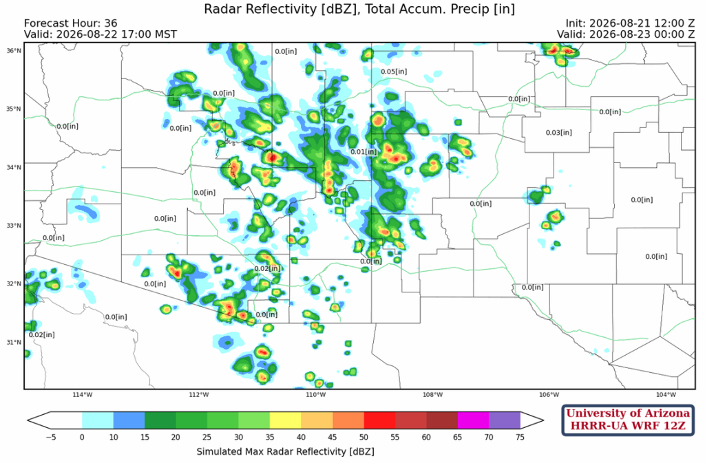
The radar reflectivity forecast shows that the only organized storms are forecast for central and western Pima County. However, they dissipate as they move northwest. Even in New Mexico, only isolated storms over the mountains are forecast.
Tomorrow
More storms are expected tomorrow afternoon in Arizona and fewer in New Mexico than in today’s forecast. Though neither day would we expect heavy rain or gusty winds.
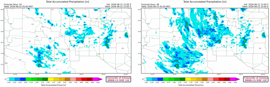
The 24-hour (below, left) and 48-hour (below, right) total precipitation forecast shows the greatest rainfall totals are predicted in central Pima County and east of Las Cruces, New Mexico, near Alamogordo. The rain is mostly over and downwind of the mountains.
Outlook
As the moisture moves around the ridge, there are some storms in northern Arizona on Sunday. Also, central and eastern Pima County has the possibility of a strong storm, with wind gusts up to 40 mph.
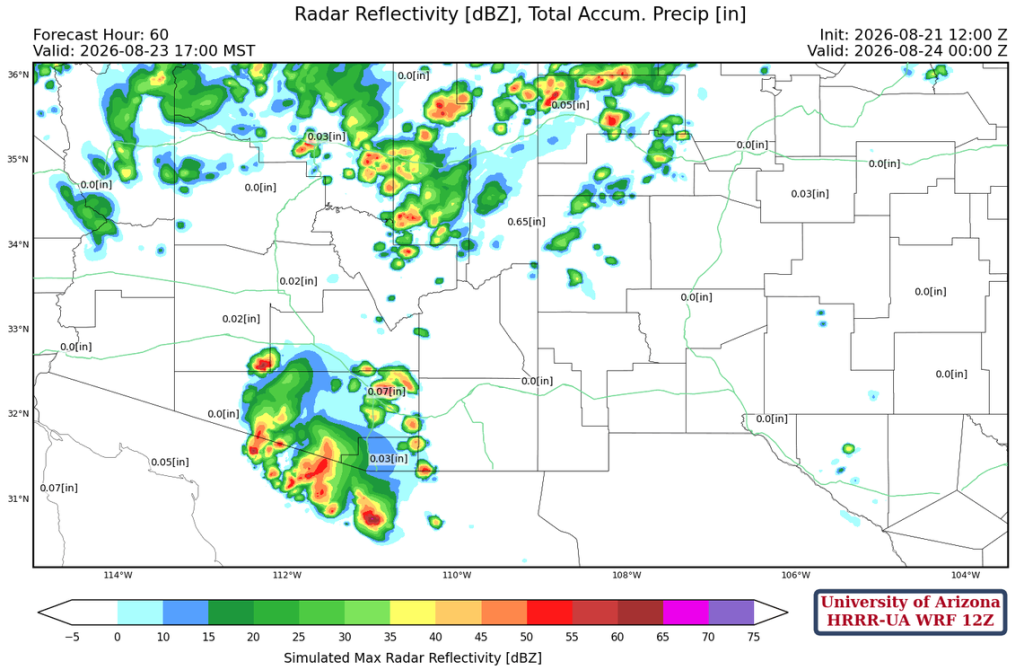
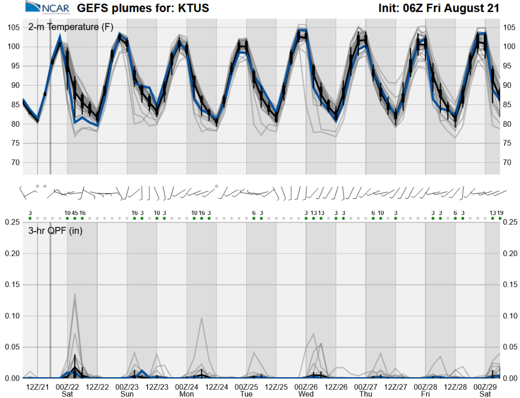
We remain in a low-grade monsoon pattern throughout next week. Storms may increase by the end of the month due to tropical activity, according to long-range global model forecasts (GFS and ECMWF).
Discussion written by Pat Holbrook and Patrick Bunn