

Summary
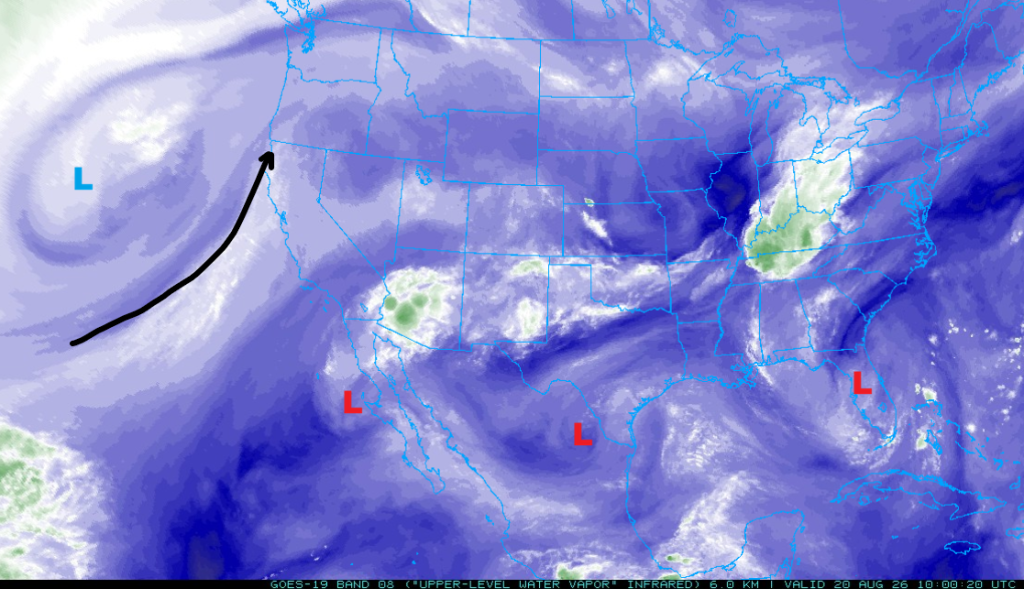
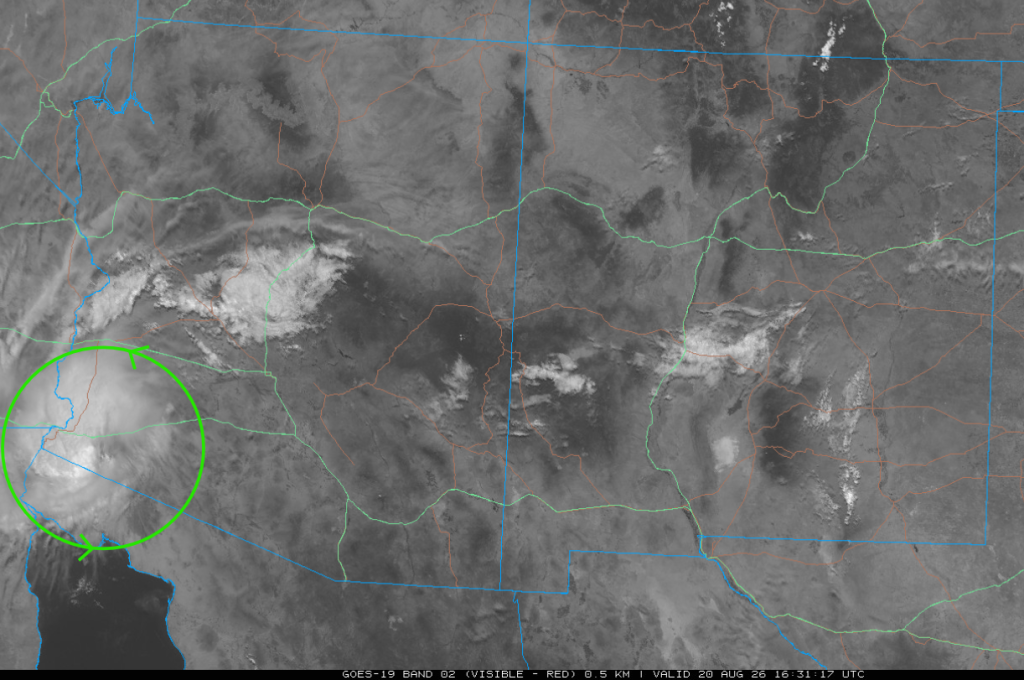
Water vapor satellite imagery shows three Tropical Upper Tropospheric Troughs (TUTT); one moving off the Baja Peninsula, another west of Brownsville, and another in central Florida. The monsoon high is positioned over west-central Arizona, influencing the movement of these troughs and the overall flow pattern. A remnant mesoscale convective vortex (MCV) from last night’s storms near Phoenix is dissipating near Yuma, while surface dewpoints remain steady due to persistent Gulf Surge moisture.
Today, most thunderstorms are expected from the Mogollon Rim into northern Arizona and New Mexico, with isolated storms in southeast Arizona producing limited rainfall. Tomorrow will bring scattered showers and thunderstorms, mainly away from the Phoenix and Tucson valleys, with no significant severe weather expected. The outlook for the weekend shows a decrease in monsoon activity, with only light rainfall anticipated across the region.
Yesterday’s Weather
Yesterday, thunderstorms moved into Tucson further north than numerical weather prediction model forecasts predicted, riding strong outflows. The fastest wind speed reported at Tucson International Airport was a gust of 63 mph. The heaviest rain fell along the Sabino/Bear Canyon washes as a thunderstorm developed there around 5:20 pm, and because of training, the storm stayed in the same location for over an hour, producing 1.85″ of rain. A swift water rescue occurred south of Tucson where additional heavy rain fell.
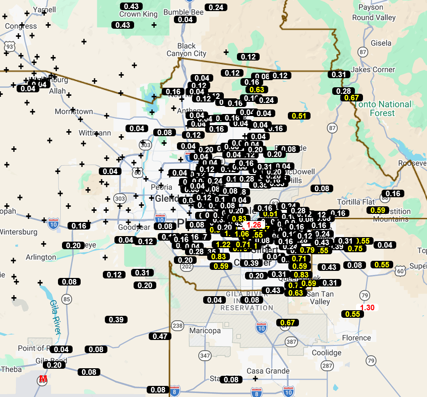
In the Phoenix area, outflows from thunderstorms to its south reached Mesa-Gateway Airport at 9:19 pm with a wind gust of 56 mph and visibility dropping to a half mile from blowing dust. High winds continued at the airport, with a maximum of 63 mph at 9:48 pm. Not to be outdone, Sky Harbor had a 68 mph wind gust at 10:00 pm. The NWS issued a dust storm warning and reported:
“At 9:14 PM MST, a wall of dust was along a line extending from Kings Ranch to near Queen Creek to near Chandler Heights, moving northwest at 30 mph.”
This sounds like a haboob, but since it was dark by then, the pictures of the haboob were not as good as if it had occurred during the day.
The infrared satellite picture taken at 10:15 pm shows a Mesoscale Convective System centered over Pinal and Maricopa counties moving slowly west.

In Pima County, the heaviest rain was south of Tucson; moving northwest, the rainfall totals were lighter. Davis-Monthan AFB received 1.11″ while Marana and Pinal Air Park only received 0.01″.
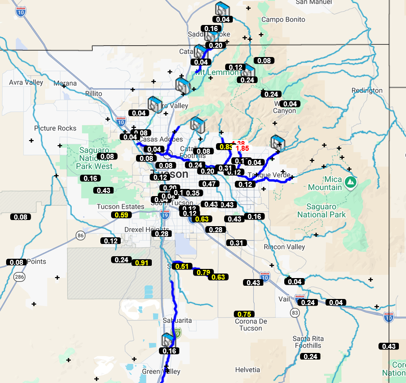
The heaviest rain in the Phoenix area was east of I-10/17, with the storms building and moving in from the southeast on strong outflows. Further west, the precipitation amounts were lighter.
The HRRR-UA WRF 12Z 24-hour accumulated precipitation forecast (left) and corresponding observed precipitation from MRMS (right) are shown below.
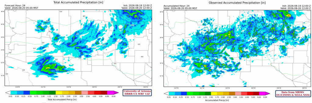
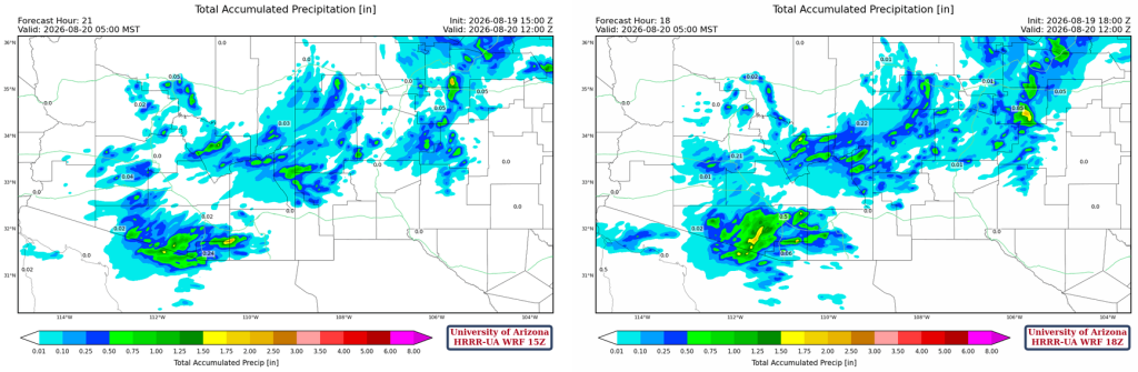
The 15Z forecast (left) and the 18Z forecast (right) are also shown. Overall, although the precipitation pattern was forecast correctly, the amount was underestimated.
Analysis
The upper-level water vapor satellite image at 4 am this morning is below. Three Tropical Upper Tropospheric Trough (TUTT) lows are visible. One TUTT low is moving west from the Baja Peninsula into the Pacific Ocean, another is moving west from northeast Mexico west of Brownsville, and a third remains stationary in central Florida. The polar low is well off the west coast behind the associated jet stream. These two features have not moved much over the last 24 hours, hence the term quasi-stationary.
The visible satellite image from 9:30 am shows the remnant circulation of the MCS that was in Phoenix last night winding down as it approaches the Colorado River, near Yuma. The circulation without the storms is a Mesoscale Convective Vortex (MCV), and it can steer storms that develop around its edge. Subsidence is typically present in its wake.
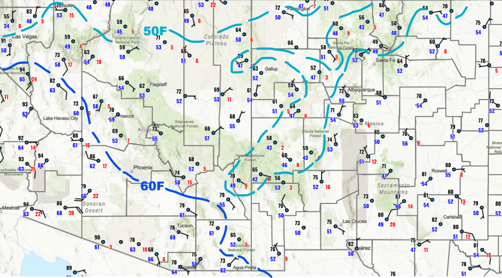
Surface dewpoints have changed little since yesterday, as Gulf Surge moisture remains in place; perhaps a slight increase in far southeast Arizona.
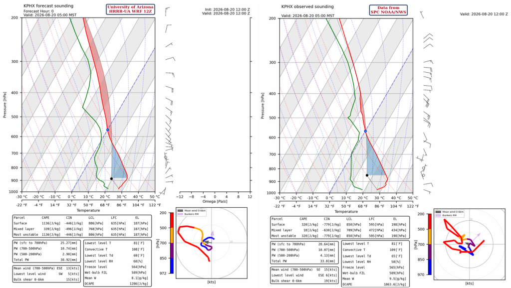
The HRRR-UA WRF 12Z initialization (left) and observed (right) sounding for Phoenix at 5 am are shown below. Both soundings are classic onion-shaped, showing cooling at 800 mb below from last night’s MCS. The observed sounding has nearly twice the Convective Inhibition (CIN) as the forecast initialization.
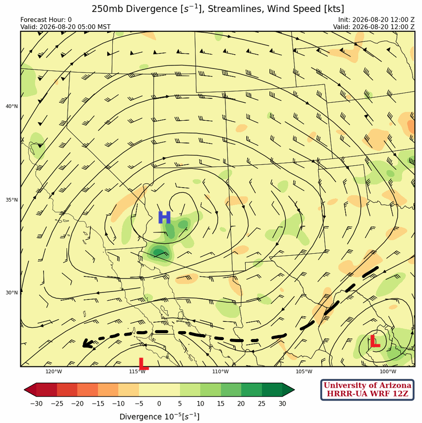
At 250mb, the monsoon high is over west-central Arizona, with the two TUTT lows further south and moving west. The TUTT off the Baja coast will move further west and get absorbed by the jet stream. The TUTT low west of Brownsville will move into central Mexico and change our flow to southeast by Saturday as the monsoon ridge moves to the Texas Panhandle.
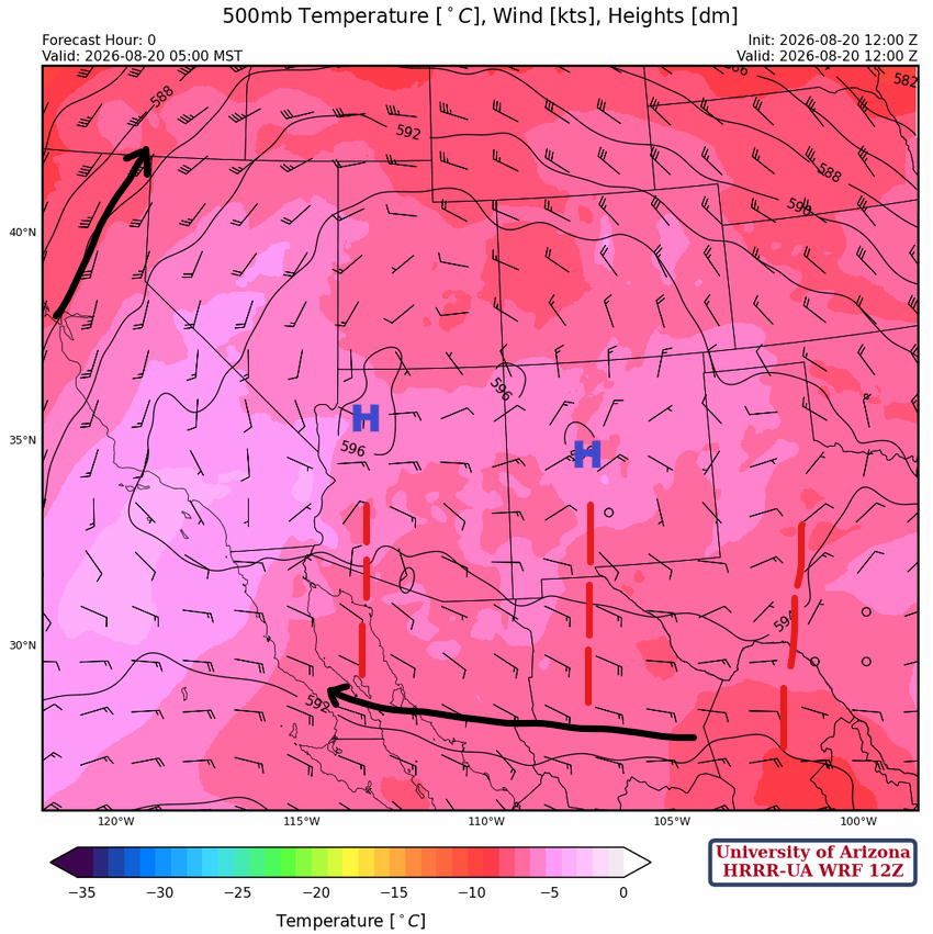
At 500mb, the monsoon ridge stretches across northern Arizona with a deep fetch of easterly flow with three waves moving west underneath the ridge.
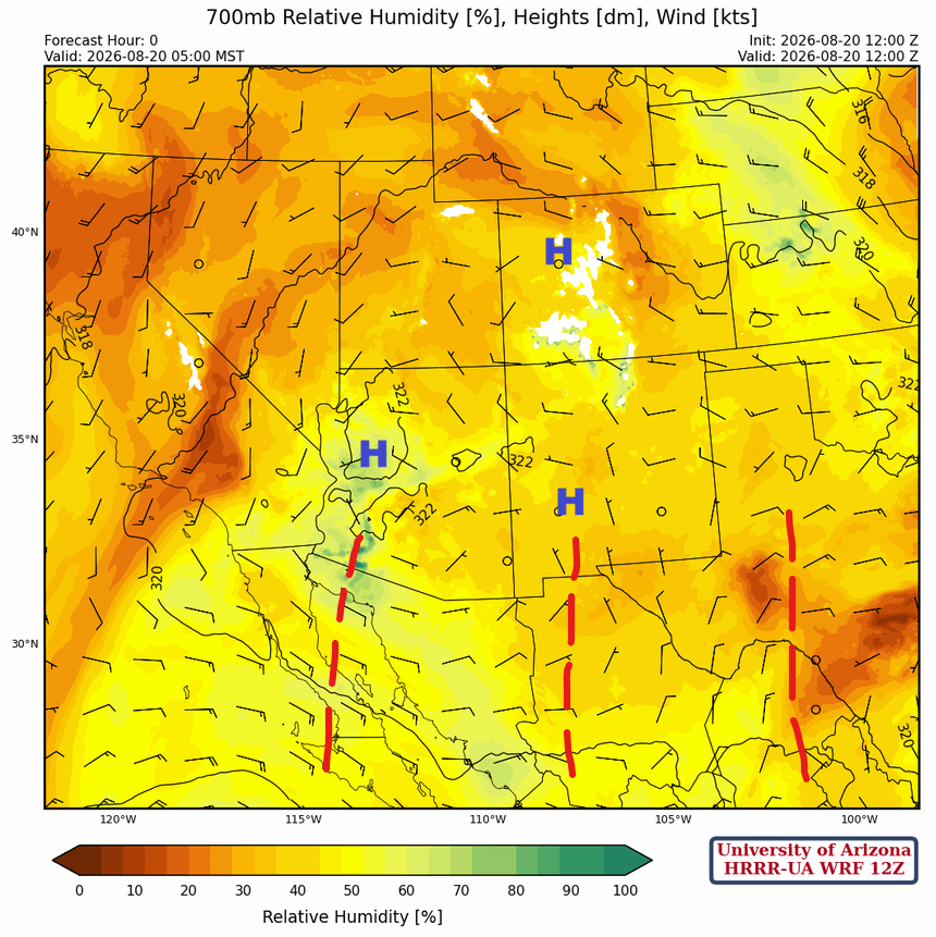
At 700mb, the monsoon high has three centers partially created by the action of the troughs moving westward underneath the ridges. The one extending south into Mexico from Deming may enhance storms in far southeast Arizona this afternoon.
Today
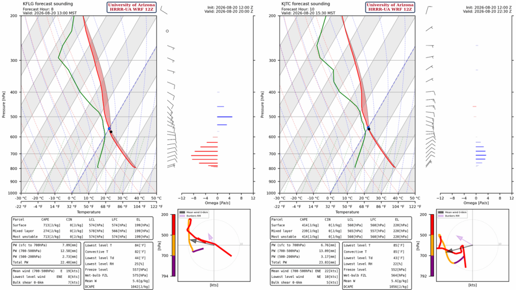
The forecast sounding for Flagstaff at 1 pm (left) and Springerville at 3:30 pm (right) both show an atmosphere that is favorable for thunderstorm development as they were not affected by last night’s MCS. The Phoenix, and Tucson, sounding show the onion shape that indicates the CAPE will not be able to overcome the CIN.
Today, the majority of thunderstorms form from the Mogollon Rim into northern Arizona and New Mexico on the Colorado Plateau.
Storms will be isolated in the mountains in southeast Arizona, including Tucson, but as can be seen by the 24-hour total rainfall (left) not much rain falls with these storms. Some additional rainfall is expected Friday (right) from scattered thunderstorms.

Tomorrow
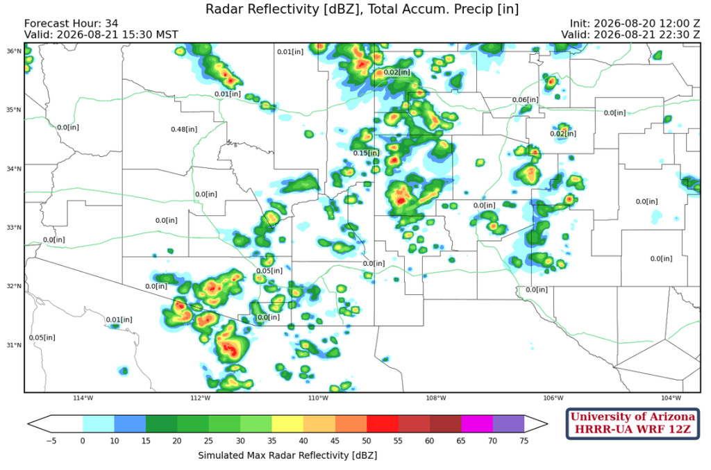
Scattered showers and thunderstorms will develop in Arizona, but heavy rain or strong winds is not expected. The storms will mostly stay away from the Phoenix and Tucson valley.
Outlook
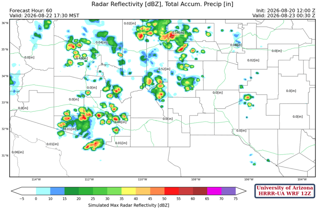
On Saturday northern Arizona and New Mexico will not have storms, although the some will develop in western Pima County and north to Maricopa County and Phoenix.
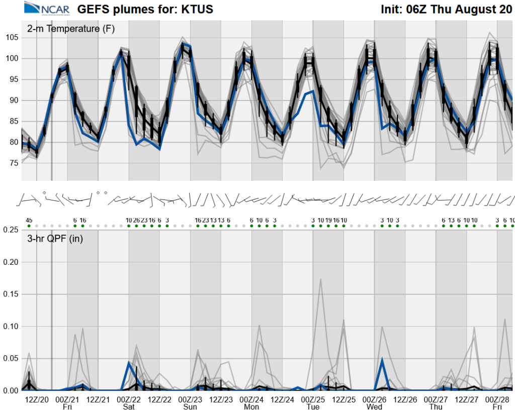
Long-range global model forecasts have backed off to low grade monsoon levels for the weekend and most of next; note the QPF scale has changed to 0 to 0.25″, so even the outlier are below 0.25″.
Discussion written by Pat Holbrook and Patrick Bunn