

Summary
Tropical storm Lowell recently affected Hawaii with strong winds and heavy rainfall, especially in mountainous regions. Meanwhile, the remnants of Marie brought rain and coastal impacts to southern California, but flooding was minimal. Upper-level water vapor satellite imagery shows moisture transport from remnants of Marie into California and another flow from Mexico into AZ/NM. The subtropical high has reformed over the region, and moisture is available; mid-level temperatures are a bit high and will limit activity over most of Arizona except the southeastern corner. Thunderstorms will develop in Cochise, Graham, and Greenlee counties and move slowly west, reaching the Tucson metro between 7 and 9 pm.
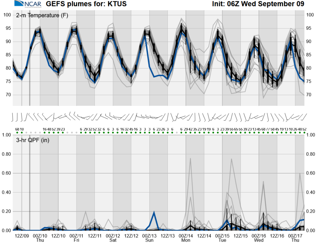
Forecasts indicate more precipitation today than tomorrow, with storms mainly in southern Arizona and along the international border by tomorrow. One long-range model (GEFS) suggests a chance of more storms early next week from tropical activity, though it differs from the European model (ECMWF), which takes the tropical moisture west away from the Southwest.
Yesterday’s Weather
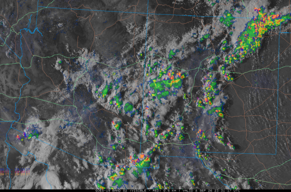
Visible satellite imagery overlaid with radar and lightning at 4:30 pm shows showers and thunderstorms extending from southeast Arizona northeast to southwest New Mexico and further northeast into southeast Colorado. Additional storms were on the Mogollon Rim, extending east into west-central New Mexico. Some light showers fell in the early morning hours in Pima and Graham counties. No severe weather was reported, and most of the heavier rain was confined to the mountains where precipitation was generally less than a half inch.
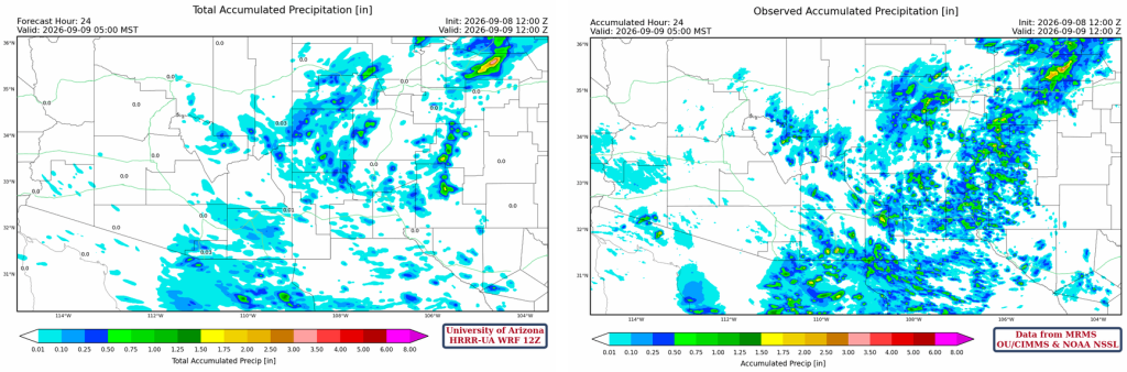
The HRRR-UA WRF 12Z 24-hour accumulated precipitation forecast (left) and corresponding observed precipitation from MRMS (right) are shown below. A good match between the forecast and observations, with only some of the totals in the sky islands underestimated in the forecast.
Analysis
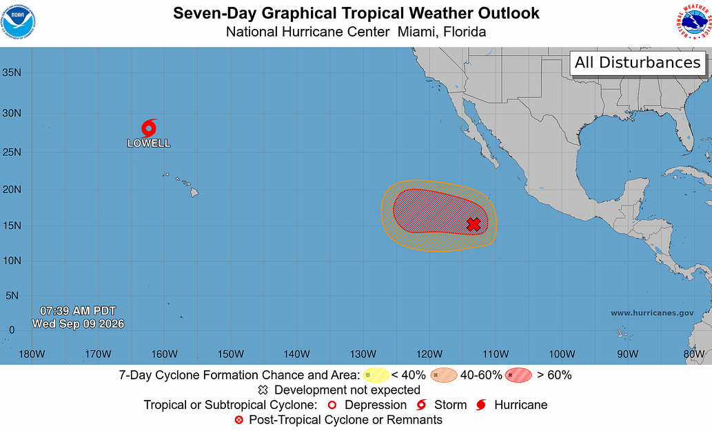
The only remaining tropical system in the Pacific Basin is tropical storm Lowell, which brushed the western islands of Hawaii. Lihue Airport had a wind gust of 75 mph. Heavy rain fell in these areas, with up to 20 inches in the mountains. More tropical systems are expected to develop well south of the Baja Peninsula over the next few weeks, with some potential to affect Arizona and California.
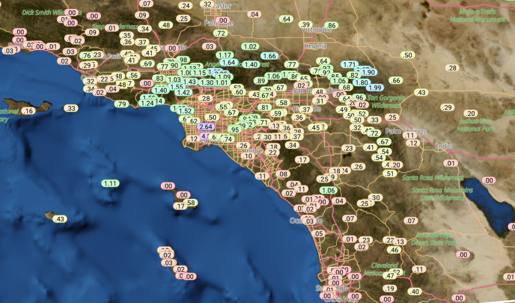
The remnants of Marie are still spinning 600 miles west of San Diego. Marie did not hit the Los Angeles area directly, but as shown by the Rainlog data, the area did receive heavy rain. Rain falling from mid-level tropical systems does not fall at a fast rate, and flooding was minimal. The more significant effects from Marie were from heavy surf, beach erosion, and coastal flooding.
The 8 am water vapor satellite imagery shows a polar low (blue “L”) and associated jet stream (black arrow) far off California’s west coast. The jet stream extends east into Montana. Moisture flows from the tropics to the remnants of Marie, then extends east into central California (red arrow). Another moisture flow comes from central Mexico northwest to southern Arizona, then northeast into southwest Kansas (green arrow). A Tropical Upper Tropospheric Trough (TUTT) has several lows associated with it from the Caribbean Sea west into Mexico, then offshore of the Baja Peninsula (red dashed line).

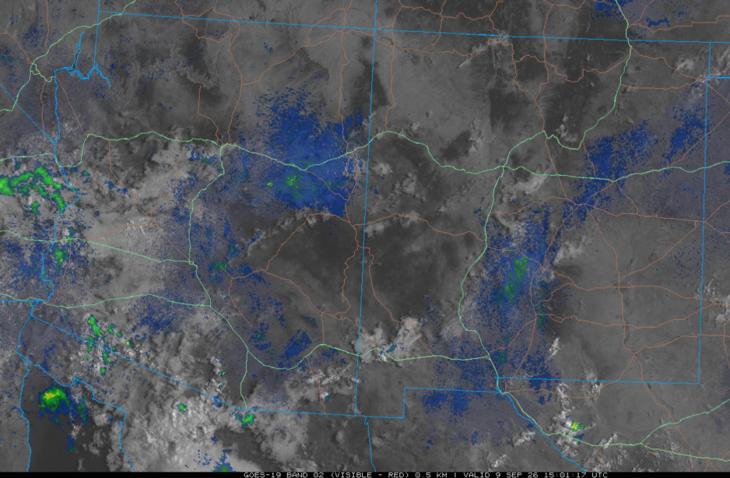
The visible satellite picture from 8 am this morning overlaid with radar and lightning images shows showers over western Arizona and southeast California. Thunderstorms are south of the international border and will continue moving west towards Puerto Peñasco. A broken layer of mid-level clouds covers western Arizona, but it’s thinning east of I-10 in central Arizona, with only isolated clouds in New Mexico.
Surface dewpoint temperatures are high over southern Arizona and southern New Mexico. Dry air is further north near the Utah/Colorado borders.

The HRRR-UA WRF 12Z initialization (left) and observed (right) sounding for Phoenix at 5 am are below. The soundings agree well. Negative factors include the dry pocket between 800 and 900 mb, the slightly warm 500 mb temperature of –4°C, and cooling from 810 mb to the surface.

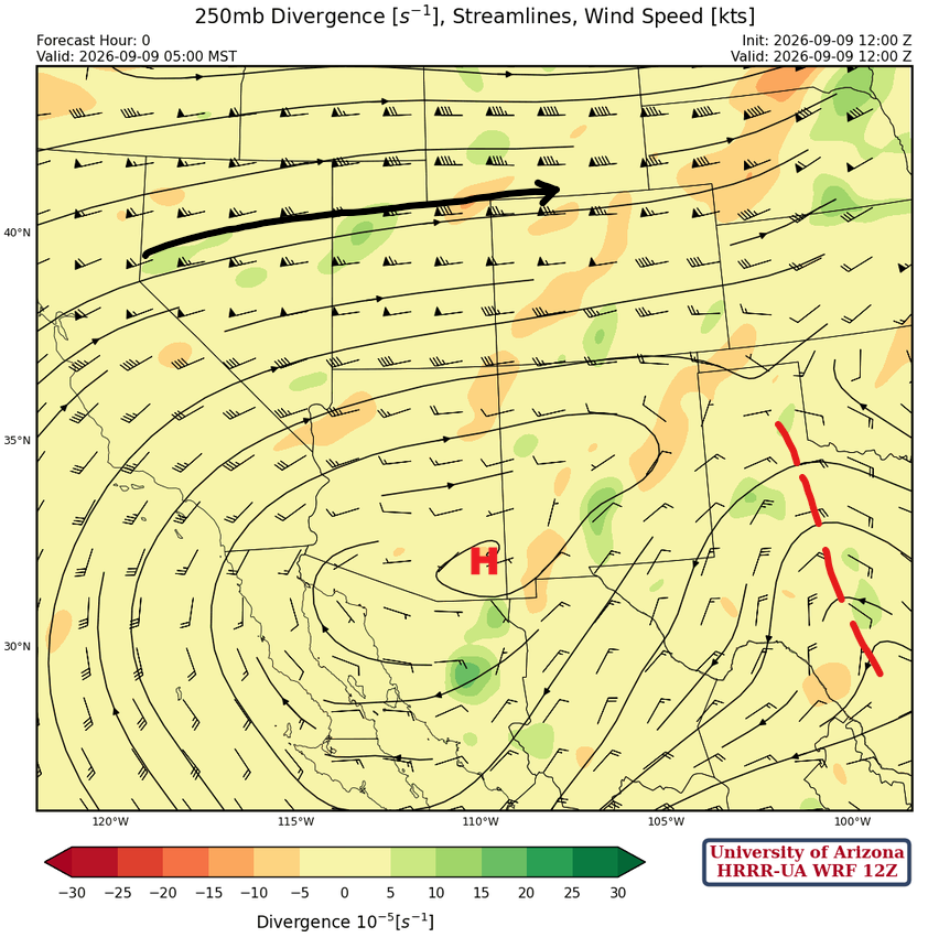
At 250mb, high pressure is centered over central Pima County with very weak flow over the southern half of Arizona and New Mexico. An inverted trough is north-south oriented from the eastern Texas Panhandle south to near Laredo (red dashed line).
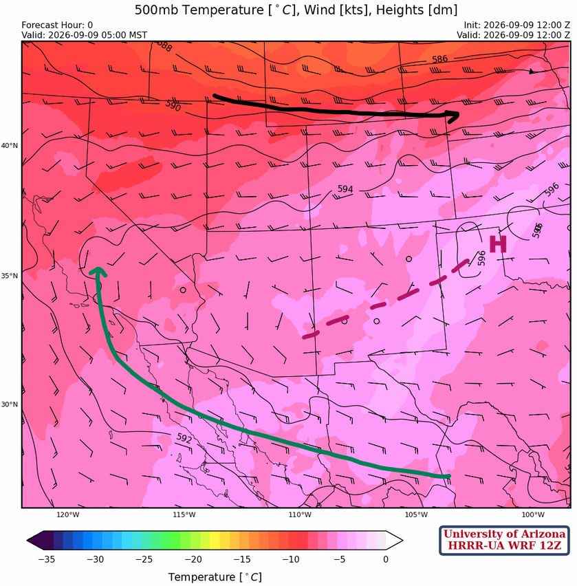
The high-pressure system is in Oklahoma, with the 500 mb axis extending to southeast Arizona, and a broad flow across northern Mexico into California. The flow in Arizona and New Mexico is weak. Temperatures are warm in the eastern third of New Mexico, which will prevent thunderstorms there.
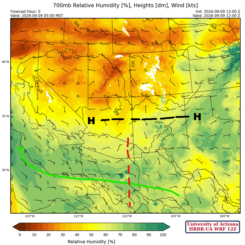
At 700mb, the high is east-west oriented from central Oklahoma across northern New Mexico and Arizona. An easterly wave appears to be entering southeast Arizona and may be the focal point for today’s thunderstorms.
Today
The Phoenix sounding (left) is for 4 am Thursday morning. There is too much Convective Inhibition (CIN) during the day, but overnight the layer between 650 and 400 mb seems unstable enough to produce some mid-level showers or a thunderstorm. In Tucson at 3:30 pm (right), the CIN is less, and the storms will develop in the mountains, then move slowly west.

The forecast radar reflectivity at 6:30 pm shows thunderstorms extending along a northeast-to-southwest axis from northeast New Mexico to Cochise and Santa Cruz counties in Arizona. The strongest storms in Arizona will be in southern and western Cochise County, with the forecast showing storms in the Tucson area between 7 and 9 pm. The exact location of the storms in the Tucson metro area is hard to predict, and different forecast runs have predicited precipitation ranging from 0.25” to 1″, with Vail and the Rincon Mountains receiving the heaviest rain.
Tomorrow
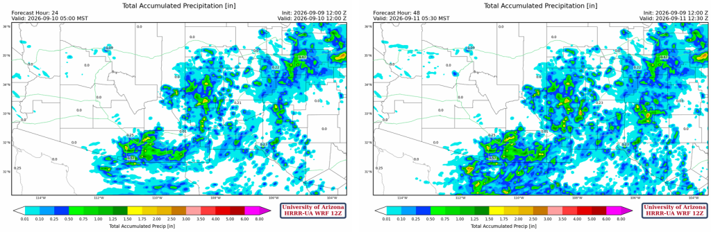
Tomorrow, moisture shifts south, and so do the storms, with southeast Arizona seeing activity in the late afternoon and evening. Cochise County and along the international border south of Nogales and Sasabe will see storms.
The total precipitation forecasts for 24 hours (left) and through 48 hours (right) indicate that most precipitation will fall today, with the rain area shifting south and east on Thursday.
Outlook
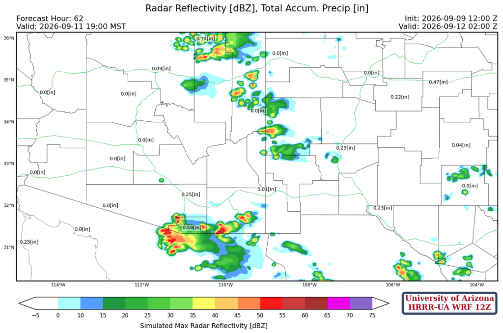
Still not much activity on Friday, with only southern Cochise, Santa Cruz, and southern Pima County having a chance. Some storms will develop in northeast Arizona, extending south to the White Mountains.
The long-range global model ensemble (GEFS) shows some possibility of storms early next week. The ECMWF model has a few tropical systems, but forecasts them to move west and not affect Arizona, so we’re skeptical of the Mon-Tues-Wed totals shown by GEFS.
Discussion written by Pat Holbrook and Patrick Bunn