

Summary
The named tropical storms in the East Pacific, Karina and Lowell, are moving west and are not expected to impact Arizona, though a potential third system could bring tropical moisture to the state. The upper-level weather pattern shows increased moisture moving north from Mexico and the Gulf of California, with atmospheric conditions favorable for thunderstorm development in Arizona.
Today, storms are expected to form around Tucson and move north toward Phoenix, potentially bringing strong winds, heavy rain, blowing dust, and small hail, with the most intense storms likely to pass through Pinal, Gila, and Coconino counties. Additional storms may develop across northern Arizona and New Mexico, moving into Utah and Colorado. The best chances for precipitation are over the next three days, after which only isolated thunderstorms are expected unless more tropical moisture arrives.
Yesterday’s Weather
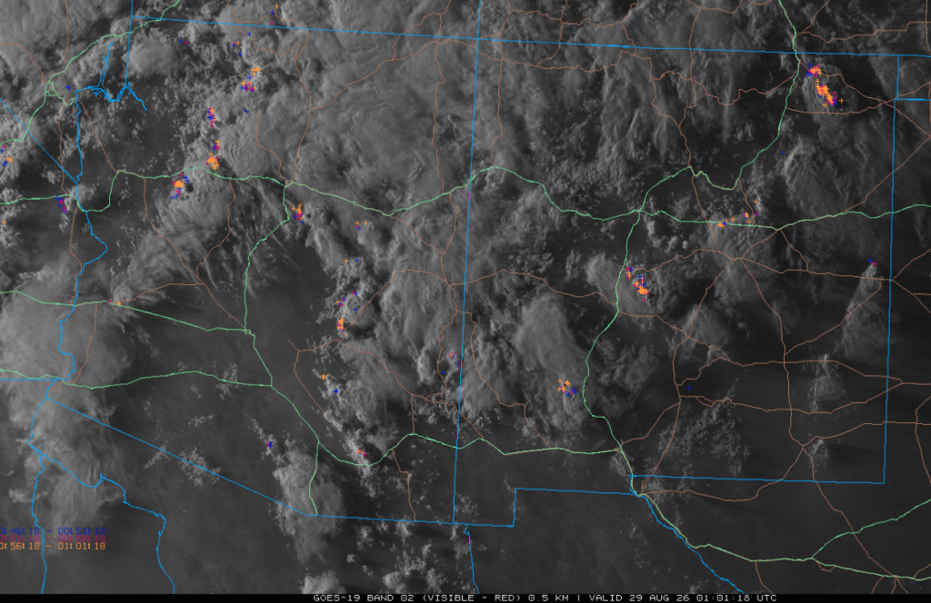
Visible satellite imagery at 6:00 pm, overlaid with lightning data, shows extensive mid- and high-level clouds over the region, mixed with isolated thunderstorms. Southwest Arizona only had a few storms.
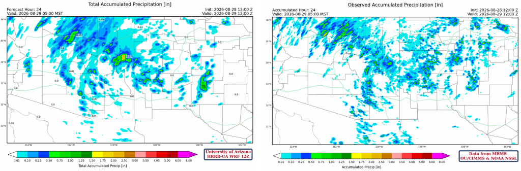
The radar reflectivity comparison, forecast left, observations right, shows mostly light thunderstorms from Tucson north to I-40. Another group of thunderstorms was from Flagstaff northwest into southern Utah. Thunderstorms in New Mexico were slowly dissipating by 8 pm.
The HRRR-UA WRF 12Z 24-hour accumulated precipitation forecast (left) and corresponding observed precipitation from MRMS (right) are shown below. Observed precipitation was a little further north than forecast, likely because the west coast trough was further north than predicted.
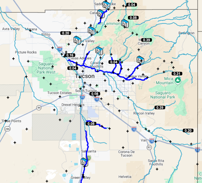
Pima County Flood Control alert gauges below show mostly light rain in the Tucson metro area, mainly from evening thunderstorms. The storms were strongest in the Rincon and eastern part of the Catalina Mountains.
Analysis
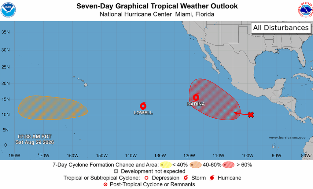
Two tropical storms, Karina and Lowell, are in the eastern Pacific basin, with the potential for a third in the red shaded area. Now it looks like neither of the existing tropical storms will affect Arizona, as they’re moving west, but the third one is still in the development stage and may bring tropical moisture into Arizona.
The Tropical Upper Tropospheric Trough (TUTT) has pushed further north in Mexico and does not appear to have any closed low-pressure systems associated with it this morning. The polar jet has dropped a little further south. Low-level moisture is moving northwest up the Gulf of California.

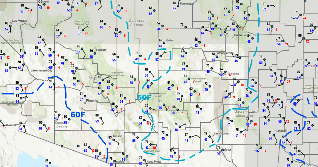
50°F dewpoint temperatures have been pulled north ahead of the Pacific trough/jet stream moving into the West Coast.
The HRRR-UA WRF 12Z initialization (left) and observed (right) sounding for Phoenix at 5 am indicate an atmosphere that will easily grow thunderstorms once the convective temperature is reached. Otherwise, the observed and forecast initialization soundings are very similar, both having about 43 mm of precipitable water.

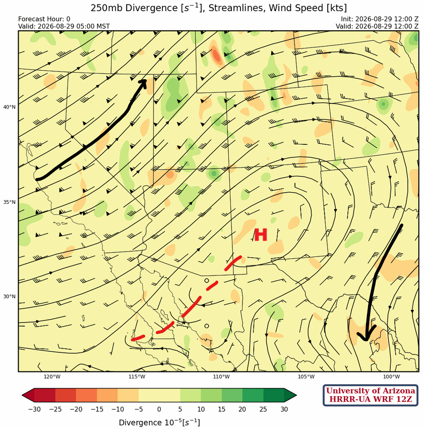
At 250mb, the jet stream has dropped south into south-central California, then northeast into Wyoming. The subtropical ridge is over west-central New Mexico, with the ridge axis extending southwest to the central Baja Peninsula. Low pressure is off the coast of Texas in the Gulf of Mexico.
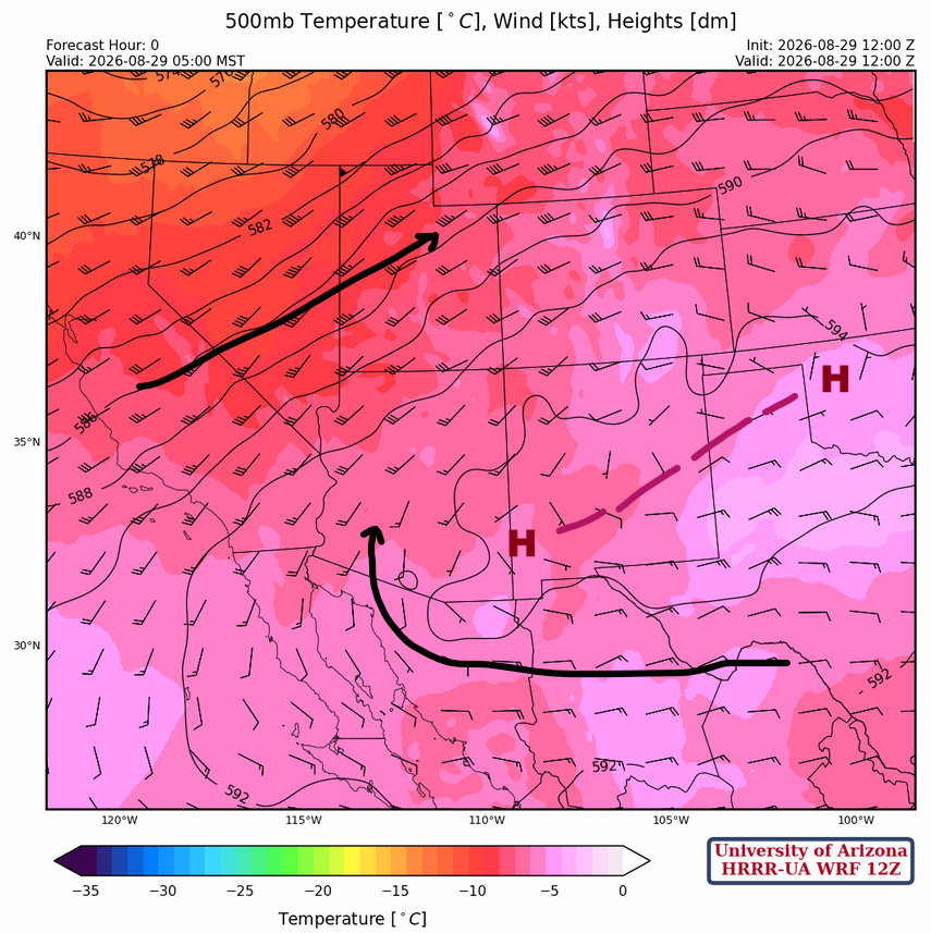
At 500mb, the ridge extends from western Oklahoma southwest to the Chiricahua Mountains. Easterlies underneath the ridge curve back to the north over the Colorado River in southwest Arizona. The jet stream at this level extends from central California northeast to Utah.
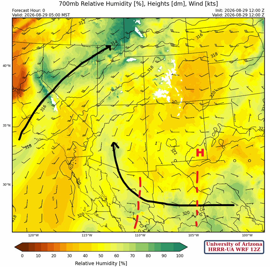
Moisture is being pulled northward from the monsoon circulation into western Arizona at 700mb. Additional moisture is associated with the front moving southeast across central California northeast into western Wyoming. The increase in the relative humidity in this area is due to a mixture of advection of moist air from the south and cooling of the atmosphere due to the trough.
Today
The forecast sounding for Phoenix at 4:30 pm (left) shows a good profile for thunderstorm development because of increased low-level moisture and convergence. The Convective Available Potential Energy (CAPE) is around 800 [J/kg] with no Convective Inhibition (CIN). Storm motion will be northward. The forecast sounding for Tucson at 2:00 pm (right) has nearly 500 [J/kg] CAPE, little CIN, and, similar to Phoenix, good wind shear.

Storms form in the mountains around Tucson by 2 pm this afternoon and take time to organize, but finally move off the mountains by 4 pm. They move north toward Phoenix, entering Maricopa County between 6 and 7 pm. The storms will produce wind gusts above 50 mph, heavy rain, blowing dust, and small hail. The forecast has storms organizing into an MCS in Pinal and Gila County moving north to Coconino. It’s perhaps a little too aggressive, but this feature is consistent across other forecast initializations (e.g., 06Z), so it’s certainly possible. The most intense storms are predicted to pass east of the Phoenix metro, fortunately, but we should prepare for the worst. Other storms will develop across northern Arizona and northwest New Mexico and move northeast into Utah and Colorado.
Tomorrow
Tomorrow, thunderstorms form at about the same time in the Tucson area and push off the mountains into Tucson between 4 and 5 pm. Again, storms move toward Phoenix and reach the metro area around 7 pm, then move up to the Mogollon Rim. These storms are a little weaker than what’s forecast for today, but still have the potential for winds up to 50 mph, heavy rain, blowing dust, and small hail. Additional storms form overnight near Prescott and in the Tucson area, extending into Graham County.
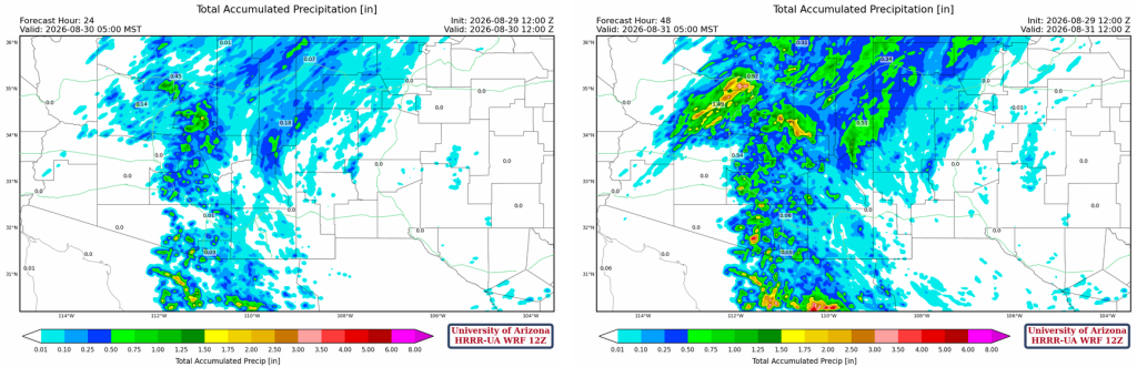
The total precipitation through 24 hours (left) and 48 hours (right) shows more rain will fall Sunday in northern Arizona than today as the trough passes through.
Outlook
The storms that form near Prescott early Monday morning are being created by a short-wave trough and will move into Phoenix in the late afternoon and Tucson during the evening.
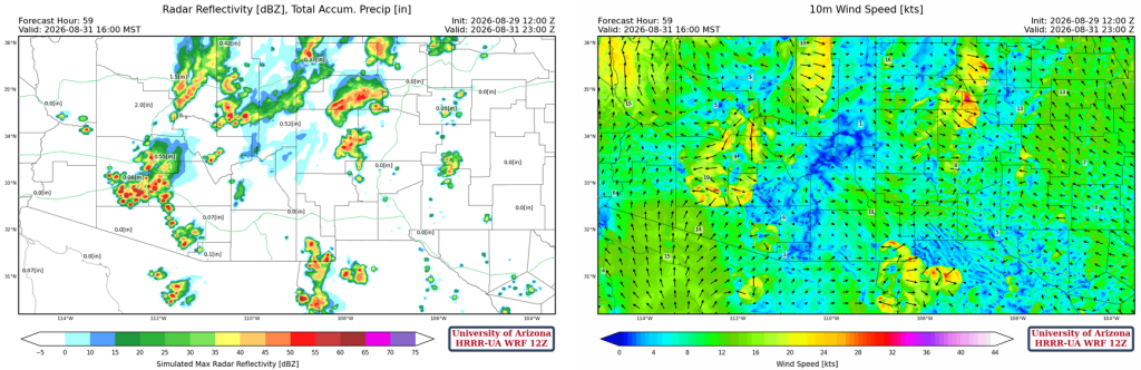
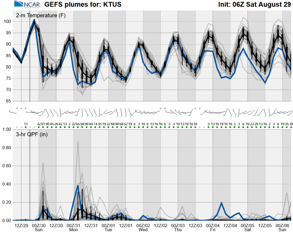
The best chances for precipitation are over the next three days. Starting Tuesday, only isolated thunderstorms are possible unless tropical activity brings more moisture into the region.
Discussion written by Pat Holbrook and Patrick Bunn