

Summary
A tropical system in the Gulf of California is bringing significant moisture north into Arizona. The interaction between the polar low along the California coast and monsoon high pressure is driving moisture north into Arizona, resulting in widespread thunderstorms and heavy rainfall across central and southern Arizona. Forecasts indicate storms building through the day, with the heavy precipitation expected in Phoenix and Tucson areas. Most of the rainfall will occur today before moving east into New Mexico by Thursday, after which a dry period is expected for much of Arizona. Rainfall amounts may vary, but we should prepare for potentially heavy downpours and continue to monitor the situation for updates.
Yesterday’s Weather
Monday’s activity drained much of the atmosphere’s energy, and yesterday’s storms in the Southwest remained along the edge of the previous day’s storms. Arizona saw scattered thunderstorms in central and western Maricopa County, the northeast part of the state, and over western New Mexico. Additional isolated thunderstorms were over the rest of New Mexico. Storms that were forecast to form along the Catalina Mountains turned out to be a stray cell that dropped 0.04 inches at one location.
To the south, a low-pressure system has been moving northward up the Gulf of California for the last two days. It has a low-level circulation and could be a tropical depression, but the National Hurricane Center (NHC) has largely ignored it, possibly because it doesn’t have hurricane potential. Given its present track, the system should be a focal point for thunderstorms in Arizona today and tonight. Both the 00Z GFS-UA WRF and HRRR-UA WRF forecasts for today correctly placed this system, though it doesn’t look as strong as it does on satellite.
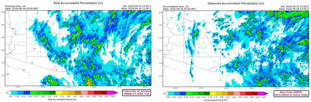
The HRRR-UA WRF 12Z 24-hour accumulated precipitation forecast (left) and corresponding observed precipitation from MRMS (right) are shown below. Yesterday’s forecast error from Tucson to Phoenix was due to cooling in the lower atmosphere from Monday’s storms. Otherwise, the forecast’s precipitation coverage and intensity were about right.
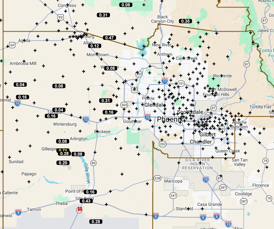
Precipitation totals for Tuesday in central and western Maricopa County are below; mostly light, other than 0.7″ near Gillespie.
Analysis
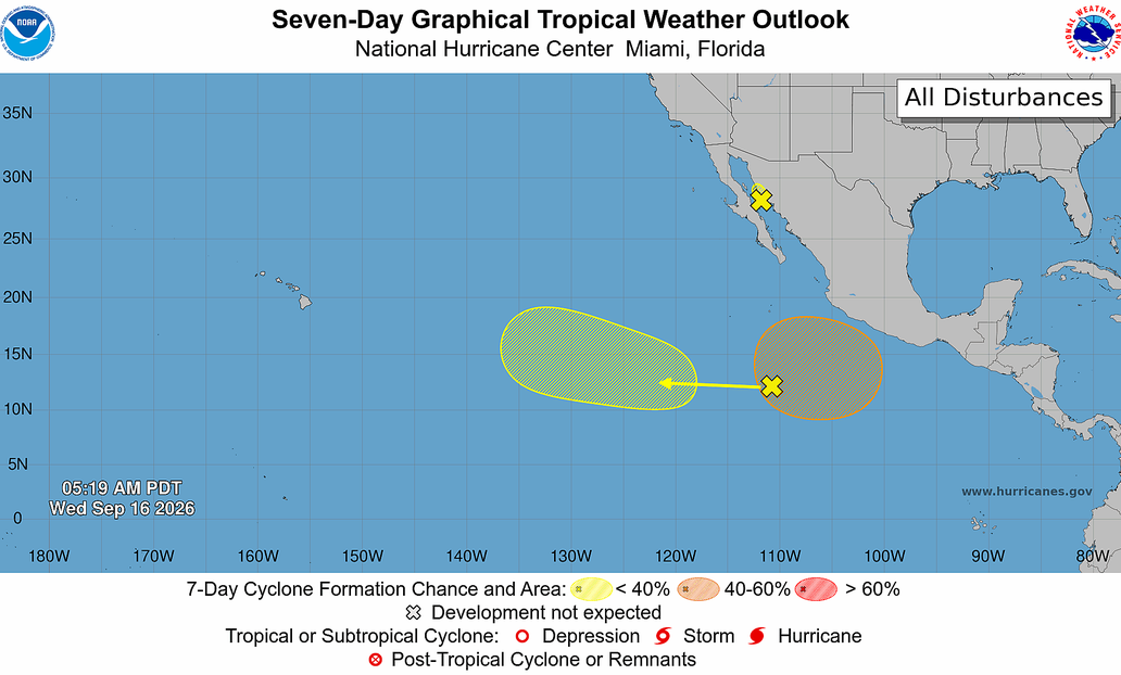
The NHC outlook is a day late in identifying the tropical system in the Gulf of California, which has been there for a few days, and this storm will be affecting Arizona over the next two days.
The polar low and jet stream have dropped southward, with the center of the low now positioned along the northwest California coast. The interaction between the low and the monsoon moisture is pulling tropical systems and moisture from northwest Mexico north into Arizona.

The visible satellite picture overlaid with radar and lightning data from 8 am shows the center of the tropical system; it’s moving north towards Nogales. Showers and thunderstorms are north of the center and bending south in a spiral-type band. Other thunderstorms are in Graham County, extending east into New Mexico. The forecast shows these storms building and moving towards the Phoenix area by late morning. These thunderstorms are associated with upper air divergence in the area. Other showers are scattered across Cochise and Santa Cruz counties.

Surface moisture shows little change, with 60°F dewpoint temperatures covering half of Arizona and New Mexico.

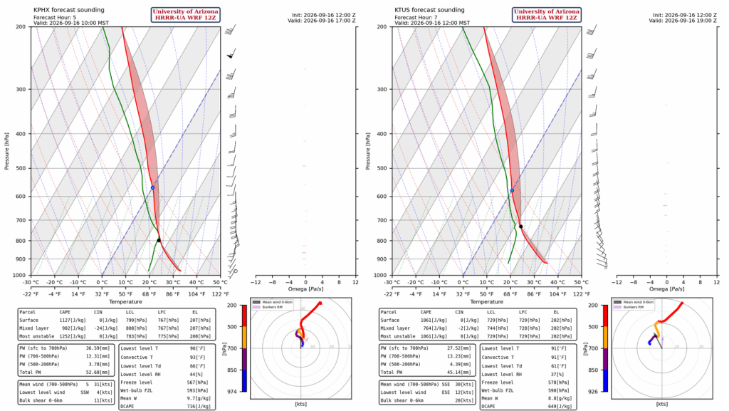
The observed sounding from Phoenix is very tropical. Precipitable water is nearly 2 inches, and convective temperature is in the low 90s (only 4 degrees above the present temperature). The forecast initialization is similar to observations, though with a little less precipitable water. Still, the forecast shows storm initiation before noon.

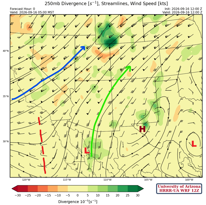
At 250mb, the tropical system is marked over Sonora, but it has no significant depth, so it isn’t visible in the flow at this level. The monsoon high is over El Paso with a Tropical Upper Tropospheric Trough (TUTT) low near San Antonio. The short-wave trough off the West Coast of the Baja Peninsula will help develop storms in Arizona today.
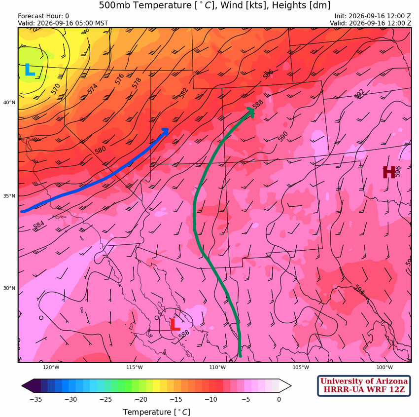
At 500mb, the ridge is over Oklahoma with a long fetch of monsoon moisture feeding into Arizona. The tropical system continues to move northward up the Gulf of California.
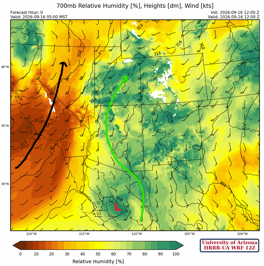
At 700mb, plenty of moisture is being pulled northward ahead of the polar low dropping down the west coast of California and the tropical system in the Gulf of California. The dry air over California will move into Arizona tomorrow.
Today
Both the Phoenix (left) and Tucson (right) forecast soundings show each location reaching its convective temperature this morning, with thunderstorms developing and moving northward. With high precipitable water, the storms could produce heavy rain across central and southern Arizona.
The forecast radar reflectivity shows a cluster of thunderstorms moving through the Phoenix metro area by 12:30 pm and other storms developing along and north of the international border in Pima, Santa Cruz, and Cochise counties. By 2:30 pm, the forecast has the storms moving into the Tucson metro area and continuing north into Pinal, Maricopa, and Graham counties. The storms will move as far west as the Arizona/Colorado border by tonight.
UA WRF ensemble mean accumulated precipitation for the event is about 0.8″ in Phoenix, with individual members ranging from 0.4 to 1.3″. In Tucson, the ensemble mean is about 0.35″ with a range of 0.15 to 1.3″. It’s best to say all these amounts will likely fall in the general area, but it’s hard to predict whether there will be a direct hit at these airport locations; we should prepare for the worst, but expect precipitation amounts closer to the mean.

Tomorrow
By midnight, most of the precipitation and the center of the tropical system will move out of Arizona, except in Maricopa and Yavapai counties. This area of storms is a convergence band to the south of the tropical system. The exact position of this area of storms is hard to predict right now, as it depends on what happens today, but as these storms move out of Arizona on Thursday, dry air in California will push moisture east into New Mexico. On Thursday afternoon, the thunderstorms will have moved into northern New Mexico and southeast Arizona.
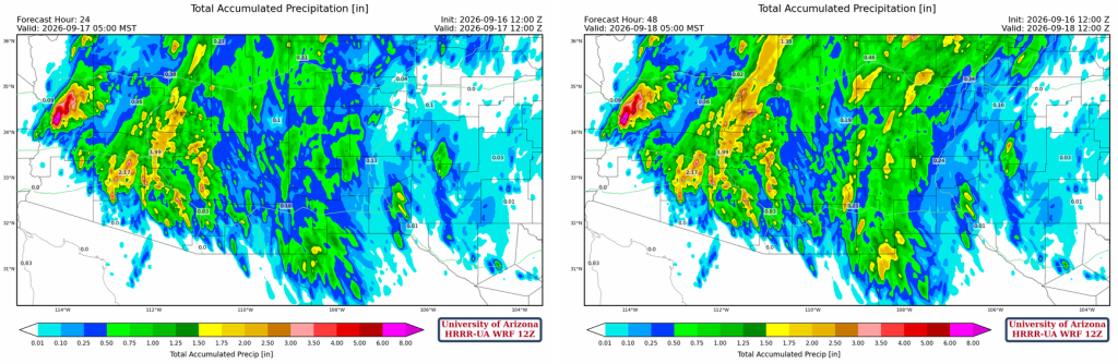
The total accumulated precipitation through 24 (left) and 48 hours (right) is shown below. Arizona receives most of the precipitation today, while New Mexico gets the heavy rain over the next 48-hour period.
Outlook
On Friday, the monsoon moisture axis has been pushed east into New Mexico, leaving all but far southeast Arizona free of precipitation.
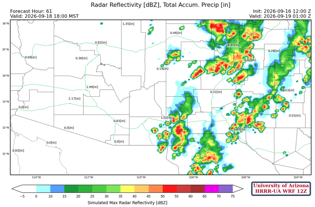
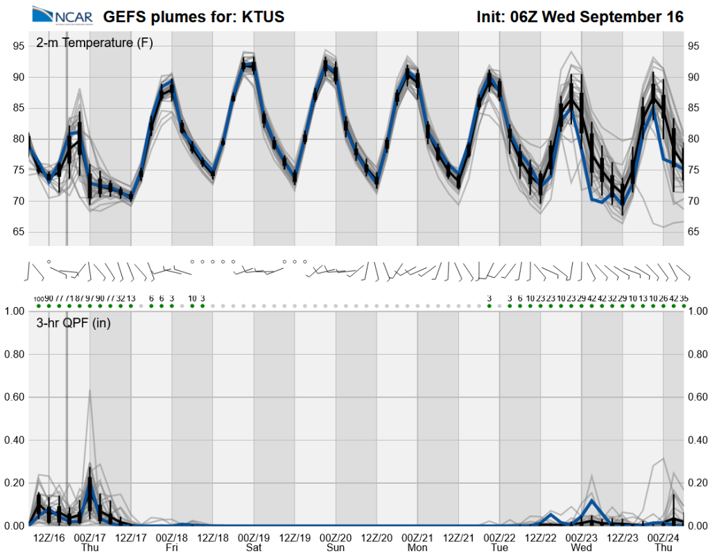
A dry period will follow today’s storms. Long-range global ensemble forecasts indicate some storms in about a week, but the monsoon flow is mainly over far eastern Arizona and New Mexico, leaving Phoenix and Tucson dry; this is very uncertain this far out.
Discussion written by Pat Holbrook and Patrick Bunn