

Summary
Tropical Storm Norbert is weakening as it moves west, and the Pacific basin is generally calm. Moisture from the tropical Pacific continues to flow up the Gulf of California and across Arizona, contributing to scattered thunderstorms, especially in southern and central Arizona. The monsoon flow has shifted slightly east, and surface conditions remain favorable for storms with high dewpoints across southern Arizona.
Forecasts show thunderstorms moving from Tucson in the late afternoon to Phoenix by late evening, with additional storms expected tomorrow from the morning and again in the afternoon, particularly along a similar northward track. Significant rainfall is forecast for central Arizona through Wednesday, but by Thursday and Friday, most storm activity will shift into New Mexico. Monsoon moisture is expected to be cut off in Arizona by Friday, likely marking the end of this active late-season period.
Yesterday’s Weather
What a day for thunderstorms in Arizona! The infrared satellite animation below shows the progression of the thunderstorm cluster from Los Mochis, Sinaloa, MX on Sunday into southeast Arizona near the international border by 4:00 pm Monday.
The storm cluster moved at about 40 mph. Because large-scale winds were less than 20 mph along the Gulf of California, the movement was driven by propagation along an outflow boundary produced by the storm cluster. The gust front moved north, staying west of the Sierra Madre Occidental. Several stations in Sonora reported wind gusts near 40 mph as the storms passed. When the storms reached maximum development, upper-level divergence in northwest Mexico aided the thunderstorms. The outflow boundary moved into Phoenix by 9:00 pm, initiating thunderstorms there too.
This has happened in previous years with a cluster of storms moving northward as this one did. In some years, the storms explode in Arizona like we saw yesterday; in other years, they weaken if they move into an unfavorable environment.
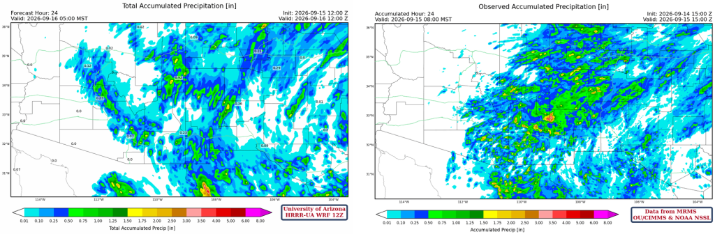
The HRRR-UA WRF 12Z 24-hour accumulated precipitation forecast (left) and corresponding observed precipitation from MRMS (right) are shown below. The forecast gets the precipitation pattern correct, but underestimates the total precipitation amount.
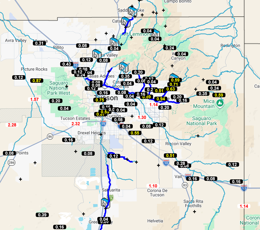
Precipitation totals from the Pima County Flood Control District Alert gauges show that heavy rain fell across eastern Pima County. At least 3 swift water rescues occurred in Tucson yesterday. Though the airport didn’t get more than a trace amount, over 1” fell on parts of the east side, 0.5-0.75” from downtown up the Santa Cruz River, and over 2” at locations on the west side.
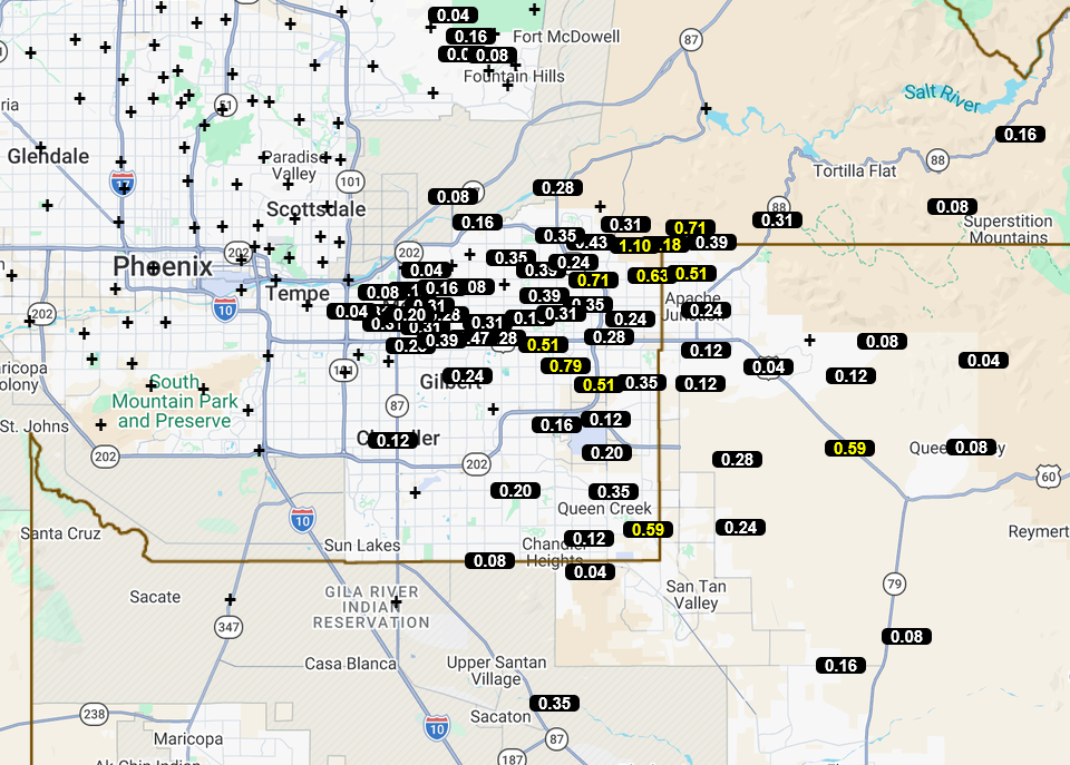
In Maricopa County, storms mainly stayed east of I-10, developing along the outflow boundary. Totals above 0.5 are in yellow, and the maximum was 1.1″ northwest of Apache Junction.
Analysis
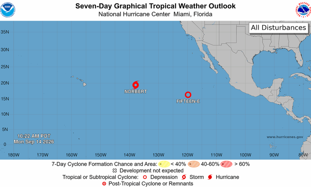
Tropical Storm Norbert is slowly dissipating as it moves west; the tropical Pacific Ocean is rather quiet right now.
Moisture continues to flow from the tropical Pacific up the Gulf of California, then turns northwest across Arizona and continues to the Great Lakes (green arrow). The Tropical Upper Tropospheric Trough (TUTT), with several low-pressure centers along it, extends from the eastern Pacific Ocean to the central Gulf of Mexico, then into the Caribbean Sea and eastward into the tropical Atlantic Ocean (red dashed). The polar low and jet in the Pacific Northwest are moving southeast (blue “L” and arrow). Another cluster of storms is near Los Mochis again this morning, moving northwest up the Gulf of California, but moving more slowly than yesterday’s cluster.

Visible satellite imagery overlaid with mosaic radar from 7:30 am this morning shows only a few showers across northern Arizona and eastern Arizona into New Mexico. The monsoon flow has shifted slightly east.

Surface moisture is in place for thunderstorms today, with above 60°F 2-meter dewpoint temperatures across the southern half of Arizona.

The HRRR-UA WRF 12Z initialization (left) and observed (right) sounding for Phoenix at 5 am are below. The forecast initialization sounding and the observed sounding are amazingly similar.

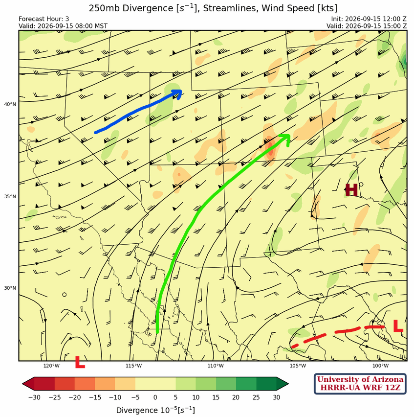
At 250mb, the polar jet is from central California into southern Wyoming. The high-pressure center is over southeast New Mexico, with monsoon flow from Baja California to Colorado.
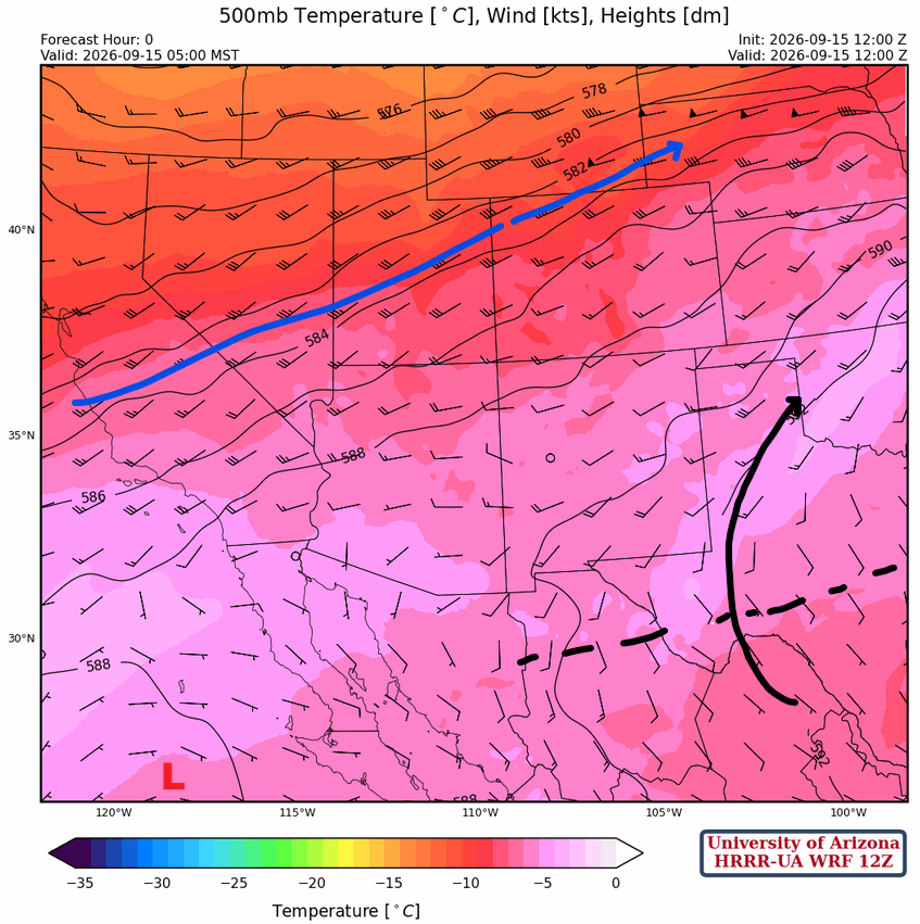
At 500mb, the polar jet is in a similar location as yesterday, flowing from California to Nebraska, while the monsoon ridge is in Alabama, with the ridge axis extending west to northern Mexico.
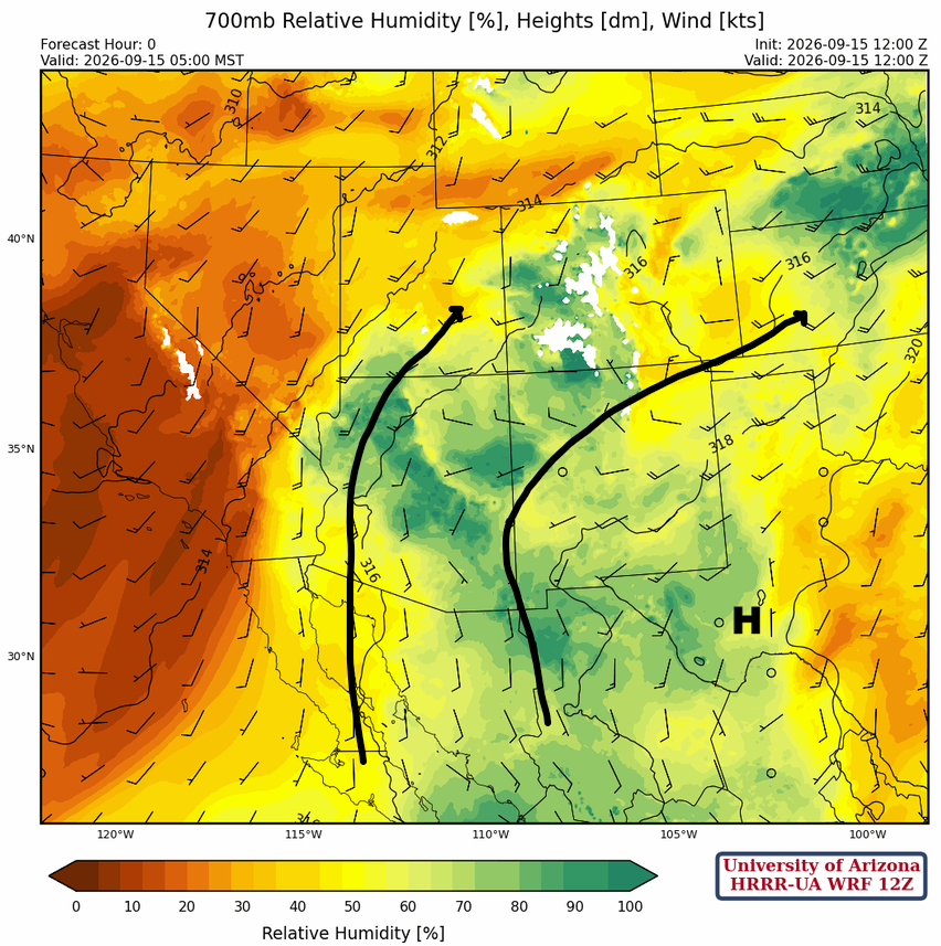
Two moisture flows are entering the AZ/NM region at 700mb. The flow up the Gulf of California is due to the polar low/jet stream to the north. The flow out of northern Mexico into southeast Arizona is due to flow around the monsoon high near Big Bend, TX.
Today
The 12Z HRRR-UA WRF forecast sounding for Phoenix at 10:30 pm (left) shows an atmosphere with plenty of Convective Available Potential Energy (CAPE) for storms but needing a little push from outflow to overcome the Convective Inhibition (CIN). At 6:00 pm in Tucson (right), the CIN is lower and should be overcome by nearby thunderstorm outflows. The outflow from these storms will move northwest into Phoenix.

The forecast radar reflectivity shows the thunderstorms that move from Tucson at around 6 pm to Phoenix about midnight along and east I-10.
Tomorrow
A cluster of storms in the Gulf of California will move northward along a similar track to Monday’s activity, but moving more slowly. The cluster is just south of the border by 5 am and reaches Phoenix around 10 am. By afternoon, additional storms form in southerly flow in the Grand Canyon, Flagstaff, and central Arizona to the International Border in New Mexico.
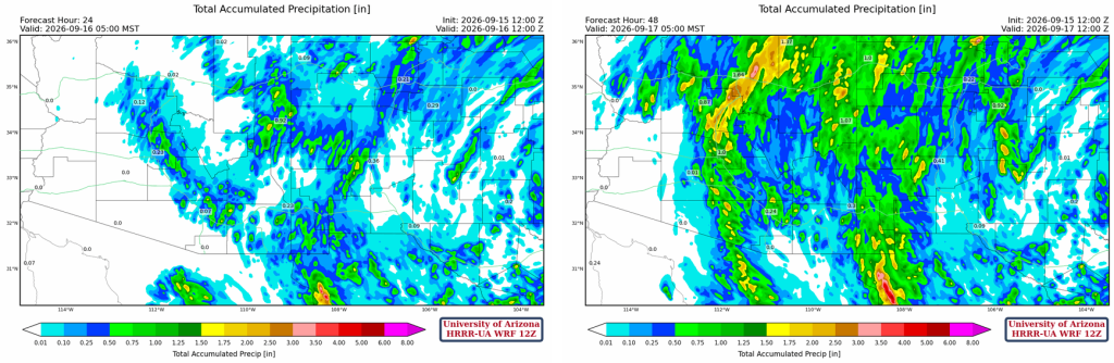
The total precipitation through 24 (left) and 48 hours (right) is shown below. The position of the heaviest rain band on Wednesday will be dependent on the position of the short-wave trough associated with the polar jet to the north.
Outlook
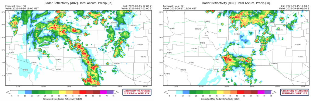
Wednesday should be the last day of significant precipitation in Arizona, as most storms will move into New Mexico Thursday evening and Friday.
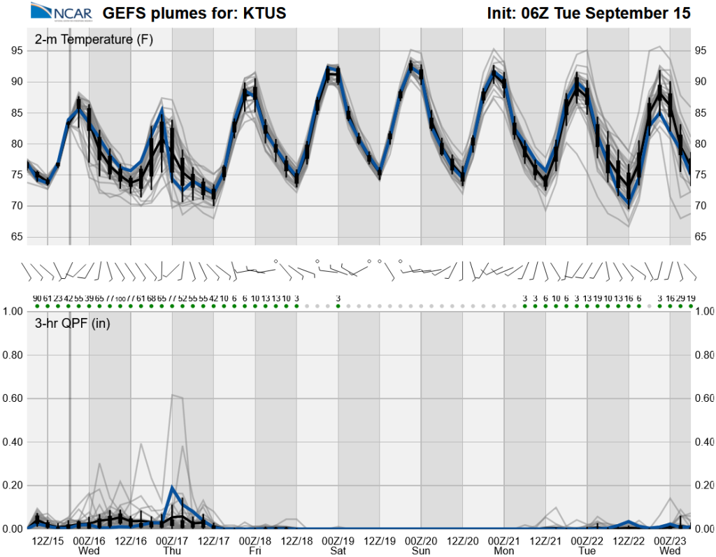
Monsoon moisture is cut off in Arizona by Friday, and this will be the end of this late-season active period. The hurricane center outlook is quiet, so unless something changes for the last week of September, this could be the end of the monsoon season.
Discussion written by Pat Holbrook and Patrick Bunn