

Summary
Surface dewpoint temperatures have increased above 60°F in the low deserts due to a moisture surge from the Gulf of California and thunderstorm outflows. The observed sounding from Phoenix indicates a persistent moist layer above 500mb, but the associated cooling from the Gulf Surge and outflows has raised Convective Inhibition, making it difficult for storms to form solely from surface heating. The monsoon high-pressure system remains largely stationary across Arizona and New Mexico, with strong winds and some dry air entering eastern Arizona.
Today’s forecast predicts intense thunderstorms, particularly in southeastern Arizona, with high rainfall rates, small hail, and strong outflows, especially around Tucson. Rainfall totals in Tucson could reach up to 0.6 inches. Storms are expected to weaken as they move west toward Phoenix, bringing lighter showers and gusty winds.
Thunderstorms will form again tomorrow, though their westward extent will be limited due to today’s activity. The monsoon pattern remains steady, with storm activity likely to decrease by the weekend before potentially increasing again next week.
Yesterday’s Weather
Yesterday, southeast Arizona experienced severe weather, mostly wind reports and one large hail report in southwest New Mexico. The highest winds reported were at Sunizona (88 mph) and Tucson Airport (71 mph). The low deserts are still moisture-starved, as dewpoint temperatures were below 50°F, though Gulf Surge moisture reached central and western Pima County, where the largest thunderstorms occurred. The gust front from the Pima County thunderstorms moved into Maricopa County after 10 pm with wind gusts below 50 mph.
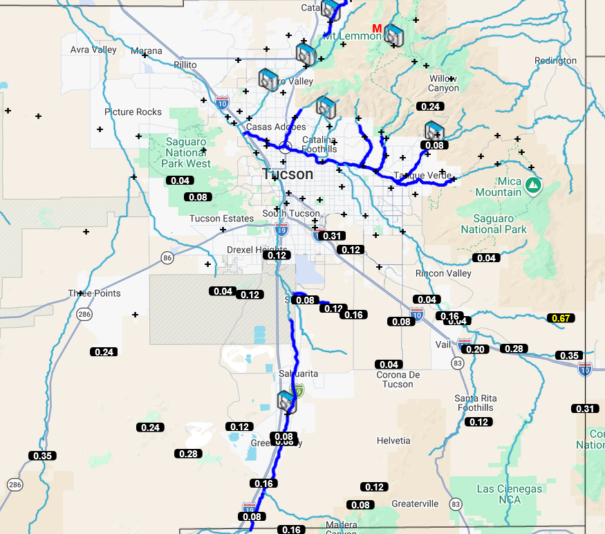
Pima County Flood Control alert system data shows trace amounts to 0.35” south of Tucson.
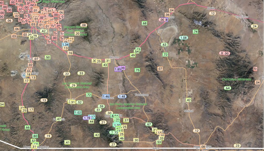
Rainlog gauges show greater totals in SE Arizona, up to 2″ south of Benson down to Sierra Vista.
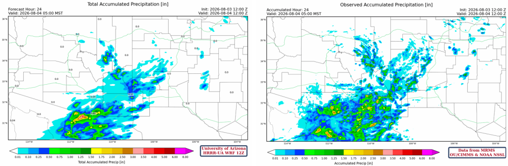
The HRRR-UA WRF 12Z 24-hour accumulated precipitation forecast (left) and corresponding observed precipitation from MRMS (right) are shown below. The forecast precipitation location was good, except for central Pima County. The intensity was underestimated in Cochise, Santa Cruz, and parts of Pima County. The precipitation forecast in Pima County, including Tucson, was accurate.
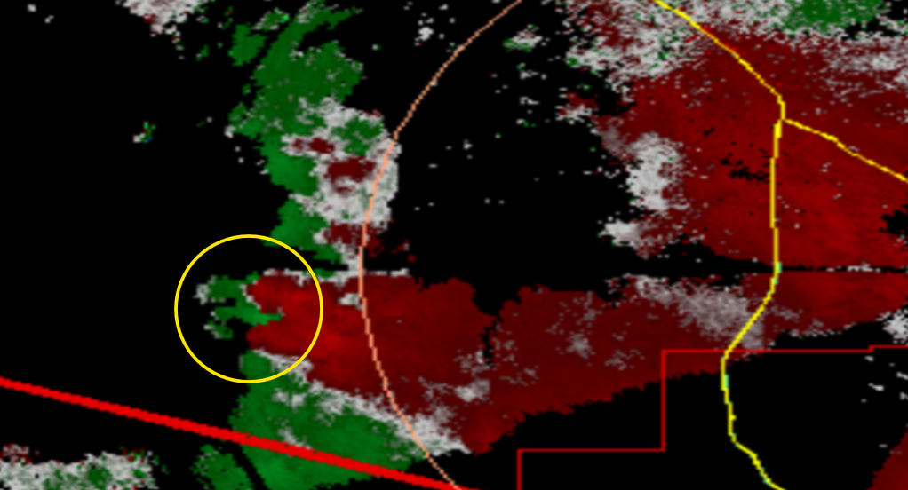
Base level velocity (below) from the Tucson KMEX Doppler Radar at 9:09 pm shows a possible tornado. The red shading is winds going away from the radar, and the green is winds going towards the radar. There is weak rotation, but since it’s so far away from the radar and the scan is less reliable at this distance, a tornado warning was justified. It will be hard to verify since the Tohono O’odham Nation is sparsely populated, but we did have one tornado there in the late 90s that was verified by the NWS.
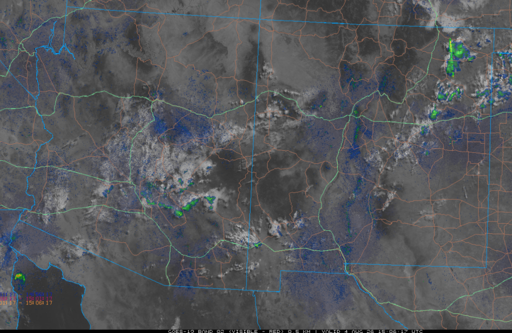
The visible satellite image at 8 am overlaid with radar reflectivity, shows clouds in central Pima County with a few light showers southeast of Phoenix moving west. The drops that are reaching the ground may get into the Phoenix metro area by mid-morning, then dissipate in the early afternoon.
Analysis
Dewpoint temperatures in the low deserts have increased to 60°F+ from surge moisture and thunderstorm outflows.

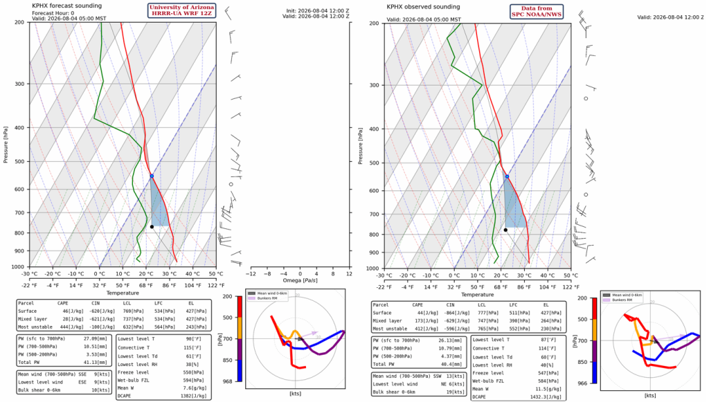
The HRRR-UA WRF 12Z initialization (left) and the observed sounding from Phoenix at 5 am (right) show a moist layer just above 500mb where the showers this morning formed. Rain has to fall 18,000 feet to get to the surface! Otherwise, the inversion at 420mb is better represented compared to yesterday. But what is missing from the initialization is the cooling below 700mb caused by the Gulf Surge and thunderstorm outflow. This has increased the Convective Inhibition (CIN) to over –500 [J/kg], which can’t be overcome with surface heating today.
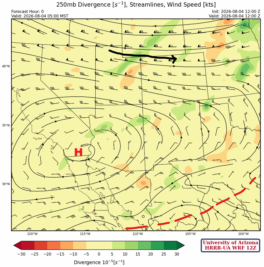
At 250mb, the monsoon high-pressure has moved very little. It’s being squeezed by the jet stream to the north and from the south by what is left of the short-wave trough, now in Mexico.
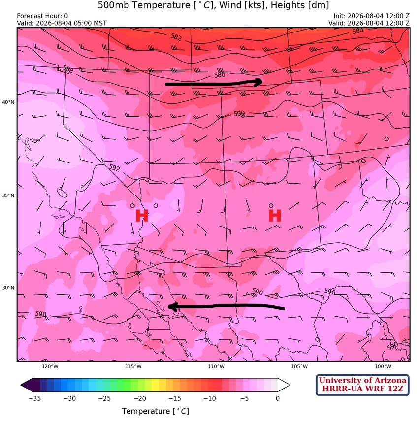
The monsoon high-pressure system is elongated across New Mexico and Arizona at 500 mb, with strong easterly winds below the high and the jet stream to the north.
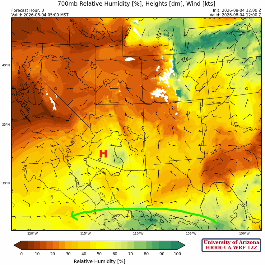
At 700 mb, there’s not much change in the location of the monsoon high-pressure center since yesterday, although some dry air is filtering into eastern Arizona.
Today
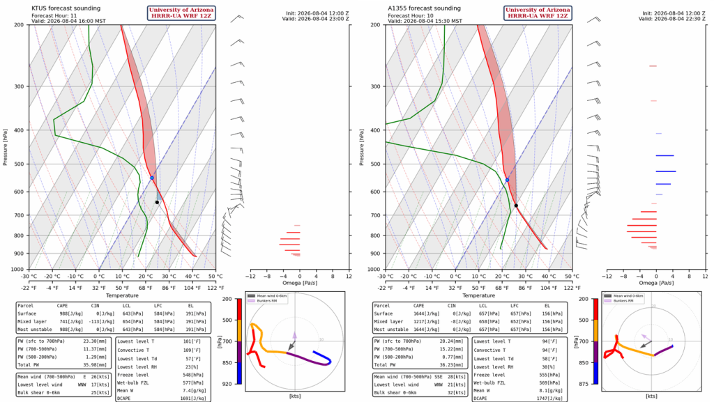
The forecast soundings for Tucson (below, left) and Nogales (below, right) this afternoon have similar Convective Available Potential Energy (CAPE) to yesterday, slightly more if anything. Storms will have no problem forming in the mountains, and they will continue to develop in the Tucson metro due to outflows; the high downward CAPE values (>1700 [J/kg]) will produce outflows over 50 mph again. Also, near-surface dewpoints are higher today, so rainfall will be more intense, with heavy rain and small hail possible.
The 12Z HRRR-UA WRF radar reflectivity and 10-meter wind forecast for this afternoon to evening is below. Thunderstorms develop on the higher terrain areas in SE Arizona (Graham, Greenlee, Cochise counties) and move southwest again, similar to yesterday. Considering how accurate the forecast was yesterday, the potential for severe weather in Tucson is high! The storms also push up to southeast Pinal County. The storms weaken as they move west, and only lighter showers will reach Phoenix, along with gusty winds and blowing dust.
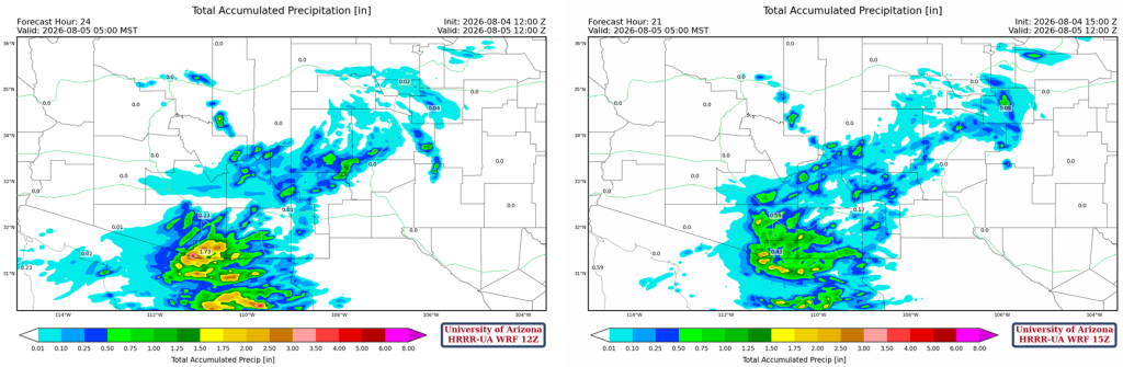
The forecast total precipitation from the HRRR-UA WRF 12Z (left) and the 15Z (right) below shows a range of 0.25” to 0.6” of rain forecast for the Tucson metro area. Given the increase in dewpoint temperatures the storms have to work with from the Gulf Surge, 15Z looks to be a better forecast, leaning toward the higher totals. The increase in moisture will allow storms to move into Pinal County.
Tomorrow
Thunderstorms form again in eastern Arizona and move west, but cooling from Tuesday’s thunderstorm outflows will limit how far west the storms will get. Eastern Pima and Tucson will see some non-severe storms before the storm intensity diminishes.
Outlook
On Thursday, the pattern does not change much as the monsoon high-pressure remains in about the same location, and the lower deserts may not have recovered yet from the cooling they will get today. Still, Tucson and Nogales may see storms again in the afternoon and evening.
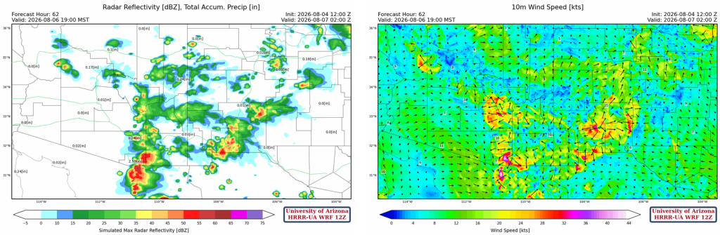
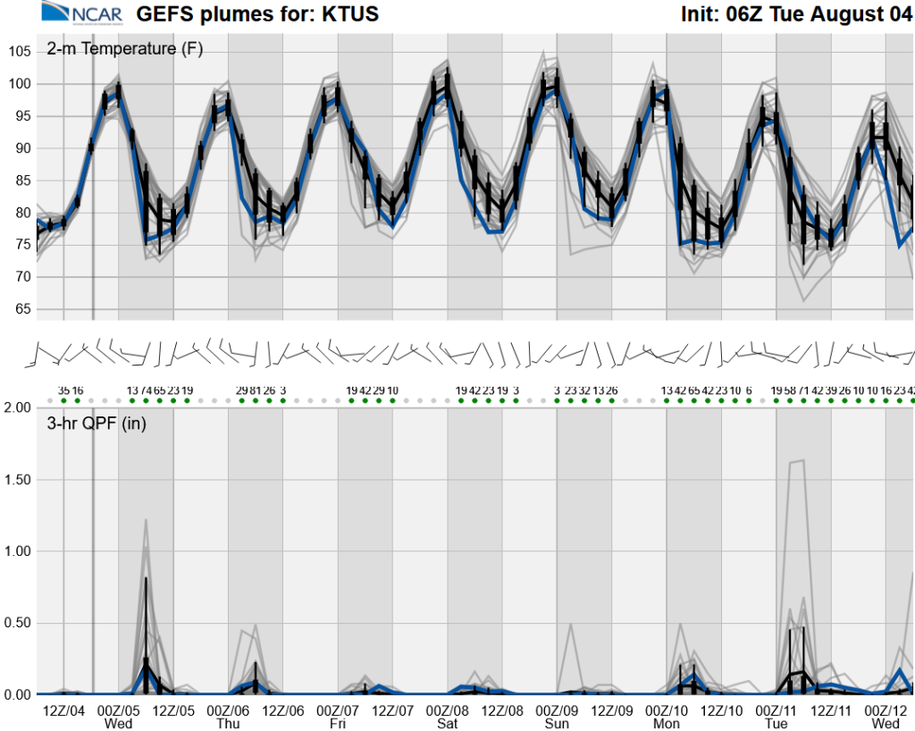
The long-range ensemble forecasts show monsoon storms will wind down by the weekend, then increase again next week.
Discussion written by Pat Holbrook and Patrick Bunn