

Summary
Upper-level water vapor shows that two hurricanes, Fausto and Genevieve, are present in the Pacific; Genevieve is expected to move away from Mexico, while Fausto will weaken as it passes north of Hawaii. A polar low over Baja California has absorbed a Tropical Upper Tropospheric Trough (TUTT); it is forecast to move up the California coast around the subtropical high. Across Arizona and New Mexico, dry air aloft has mixed down and suppressed dewpoint temperatures, and forecast soundings indicate little potential for valley storms today due to not reaching convective temperatures and warming at 500mb.
Thunderstorm activity will be limited mainly to mountains and the International border, with westward movement into Mexico and outflow-driven storms in southern Arizona. Tomorrow, slightly stronger winds may help push storms westward, but significant precipitation is not expected for the valleys.
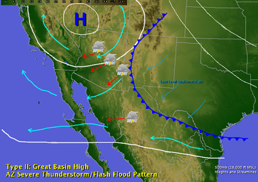
The overall outlook remains a low-grade monsoon pattern, with storm chances further decreasing as warm air aloft persists through to the end of July. A westward shift in the subtropical high-pressure could eventually bring more favorable monsoon flow conditions in August.
Yesterday’s Weather
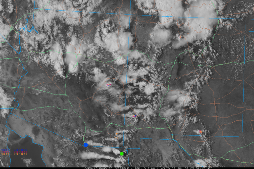
Yesterday’s visible satellite imagery shows thunderstorms were isolated over the southern half of Arizona and New Mexico as strong winds at the cirrus level sheared the tops of the thunderstorms off, as shown from where the storm was (green marker) to where the leading edge of the cirrus was (the blue marker). The cirrus was riding westward on 50-knot winds. To get winds aloft this strong requires convergence resulting in sinking air (subsidence). The areas of clear sky in southern Arizona are where the subsidence was strongest. Thunderstorms from the Mogollon Rim and north were not affected by the subsidence, but this was a down day compared to the activity on Saturday.
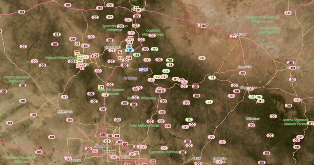
There was no reported rainfall reported on either the Pima or Maricopa Flood Control alert gauges. The Rainlog gauge observations show that thunderstorms were mostly in the mountains of Arizona and New Mexico.
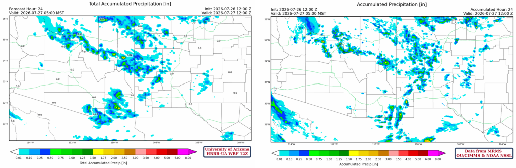
The HRRR-UA WRF 12Z 24-hour accumulated precipitation forecast (left) and corresponding observed precipitation from MRMS (right) are shown below. Except for the overestimated forecast precipitation in Cochise and Santa Cruz counties, the rest of the region was well forecast.
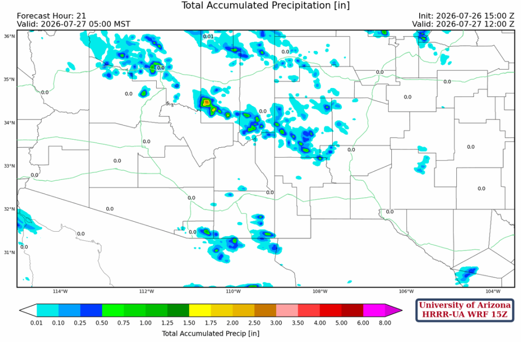
The HRRR-UA WRF 15Z forecast was more accurate for precipitation in southeast Arizona.
Analysis
A larger view from the GOES-19 satellite of upper-level water vapor shows two hurricanes (Fausto and Genevieve), two Tropical Upper Tropospheric Troughs (TUTT), and a polar low. A TUTT present yesterday was absorbed by the polar low. Fausto will weaken as it moves north of the Hawaiian Islands; Genevieve will move west away from Mexico. The low in northern Mexico will move around the ridge up the California coast.

The 60°F dew point temperature line has retreated south due to dry air aloft mixing down.

The HRRR-UA WRF 12Z initialization (left) and observed (right) sounding for Phoenix at 5 am are alike, and the only difference is the higher Convective Available Potential Energy (CAPE) on the observed sounding because the surface dewpoint temperature is too high and not representative for the area (maybe nearby irrigation a factor here).

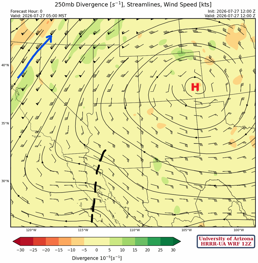
At 250mb, the monsoon ridge is in southeast Colorado while the polar jet stream is cutting across northern California. A shortwave trough is across southwest Arizona extending south to the Baja Peninsula. The trough resulted from the merger of the polar low-pressure system and a TUTT (discussed earlier). Winds aloft are a little slower today and more from the southeast. Convergence is still noted in southeast Arizona.
The shortwave trough at 300mb is not visible at the 500mb level; more upper-air data in Sonora would help here, e.g., Hermosillo. The cooler air marked in red may be a reflection of the trough at 300mb.

At 700mb, there’s not much moisture except small amounts (65-70%) in Arizona with very weak circulation near Tucson.

Today
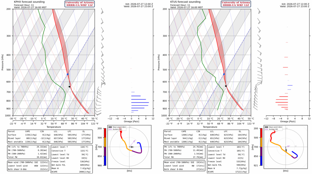
The HRRR-UA WRF 12Z forecast soundings for Phoenix (left) and Tucson (right) are amazingly similar at 4 pm. Both show precipitable water dropping during the day, and neither is likely to support storms in the valleys due to convective temperatures not being met. At 500mb in Tucson, there’s warming of the vertical profile too. Although the wind speed aloft has dropped, there is still convergence at 300mb as noted in the analysis above. The convergence may lessen, especially south of Tucson, this afternoon and evening.
Thunderstorms form in the afternoon in the mountains of northern Arizona, the Mogollon Rim, and western New Mexico. Other thunderstorms develop along the International border south and east of Tucson. The thermal wind indicates they will be moving southwest and west toward higher CAPE values in Mexico. Some storms will develop along outflow boundaries in southern Pima County this evening.
Tomorrow
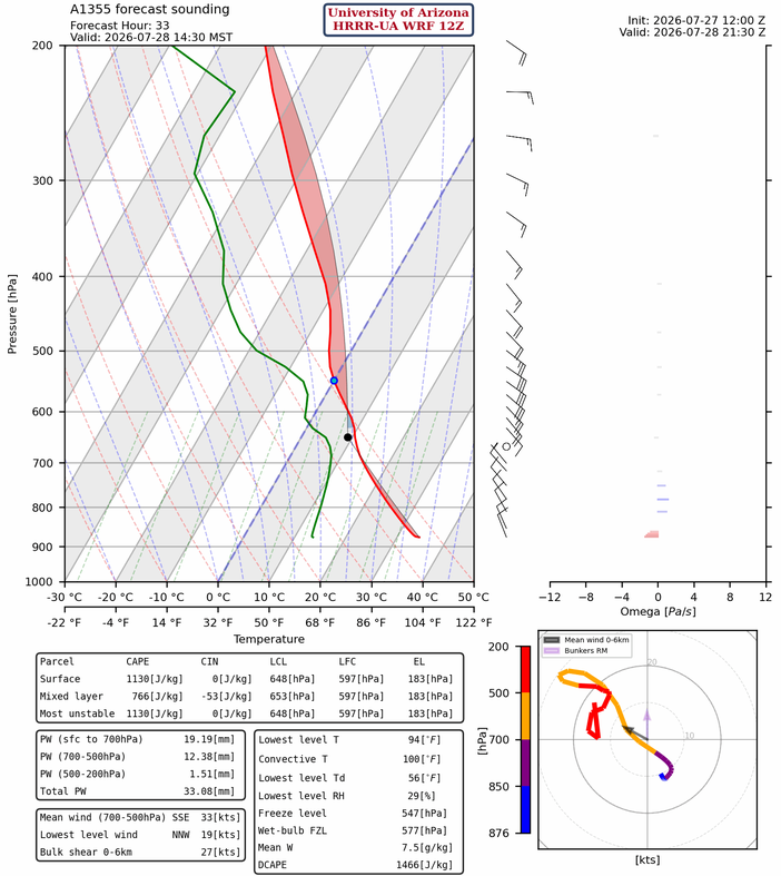
The forecast sounding for Nogales at 2:30 pm has stronger mid-level winds than today. The good news is that the thermal wind is from the east, pushing storms west.
Storms in western New Mexico and Cochise County move west into Graham and Greenlee counties during the evening and westward into eastern Pima County overnight, where they weaken. Less than 0.1” of rain is predicted in the Tucson valley.
Outlook
It’s still a low-grade monsoon situation; the cooling and clouds associated with the overnight storms will inhibit storms from forming, along with very warm air aloft as 500mb temperatures (around –2°C). The radar reflectivity forecast for Wednesday at 7 pm shows no storms in the southern half of Arizona and New Mexico.
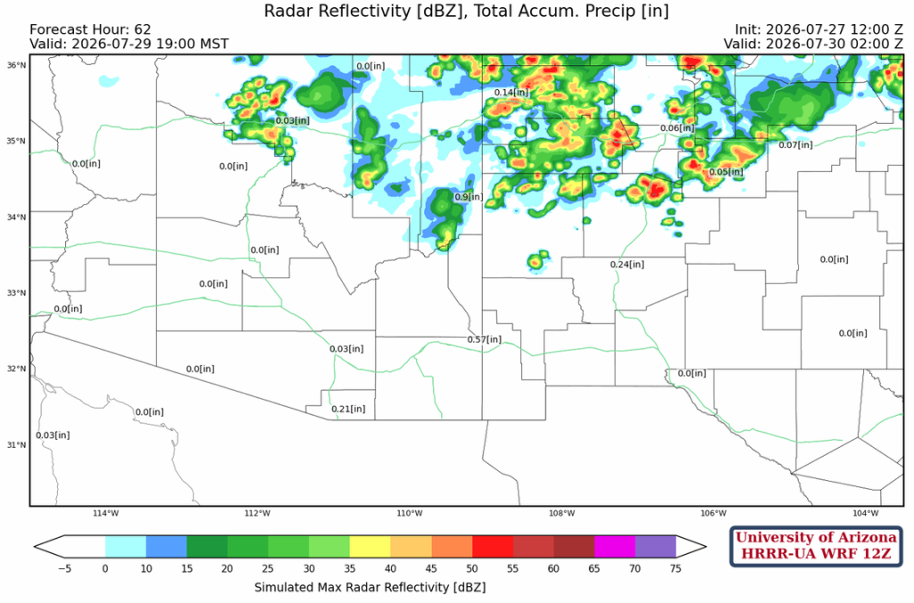
The low-grade monsoon situation persists until the end of July.
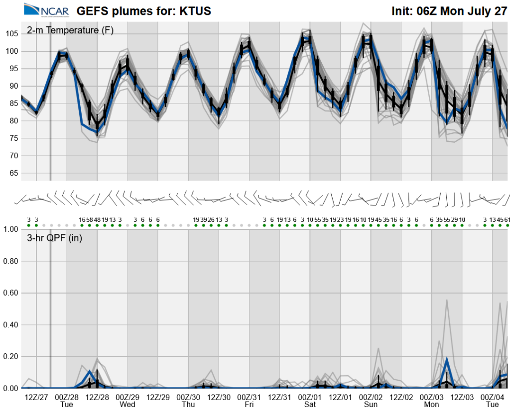
After that, the high-pressure is forecast to shift westward towards Nevada, putting Arizona in a more favorable flow for Rim Runners (type II pattern).
Discussion written by Pat Holbrook and Patrick Bunn