

Summary
A new Tropical Upper Tropospheric Trough (TUTT) has formed between Hurricane Fausto and Tropical Storm Bertha. The low-pressure system in northeast Arizona has moved into Colorado, with the subtropical high-pressure building in its wake. Hurricane Fausto remains well-organized well southwest of the Baja Peninsula, and Bertha continues to struggle with structure due to strong upper-level winds in the Gulf of Mexico. Dewpoint temperatures over southern Arizona and the Mogollon Rim are still 60°F or higher, but much of New Mexico remains dry.
Forecast soundings show less moisture over Phoenix and Tucson compared to yesterday. Lack of convective available potential energy (CAPE) will limit thunderstorm activity, while isolated storms may form over the mountains. Tomorrow looks even less favorable for storms due to higher convective inhibition (CIN), and any storms in southeast Arizona are expected to be brief and mountain-confined.
Looking ahead, a moisture surge from the Gulf of California is forecast for Saturday, likely bringing increased thunderstorm activity and higher rain chances into next week, though uncertainty remains about timing and coverage.
Yesterday’s Weather
Arizona had fewer thunderstorms yesterday, with activity focused from Cochise County northward to northeast Arizona. There was less rainfall than the previous two days. Storm motion was from the southeast in southeast Arizona and towards the northeast in the wake of the upper-level low that moved from northeast Arizona into Utah. As the low moves further, the ridge will build, and dry air will move into the western two-thirds of Arizona and suppress thunderstorm activity. This morning, the only precipitation in the two states was in the mountains southwest of Albuquerque. The visible satellite/lightning animation below shows the evolution from yesterday evening to this morning.
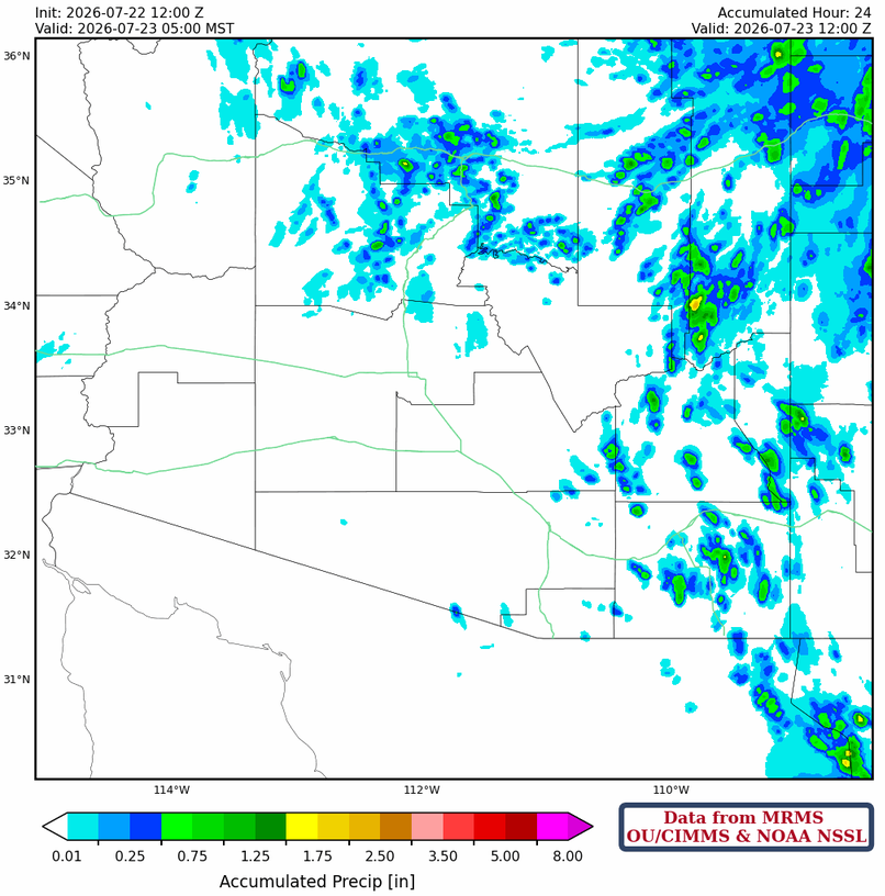
The heaviest rainfall was on Pinetop >1.5” and the Navajo Reservation with 1” near Tségháhoodzání at Fort Defiance. Most of the precipitation was from the Mogollon Rim and White Mountains north into Utah and Colorado. The southern part of Arizona did have isolated storms over mountains.
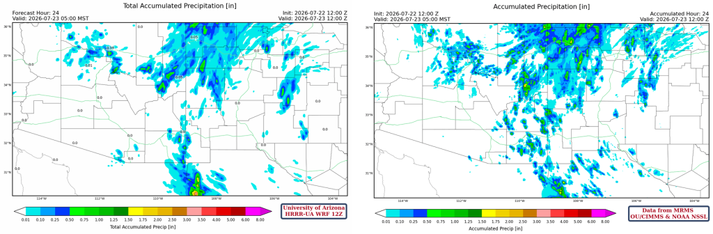
The HRRR-UA WRF 12Z 24-hour accumulated precipitation forecast (left) and corresponding observed precipitation from MRMS (right) is shown below. Except for missing some isolated mountain storms in Cochise, Greenlee, and Graham counties, this was a really good forecast!
Analysis
The Tropical Upper Tropospheric Trough (TUTT) over the Baja Peninsula has weakened and is no longer observable. A new TUTT is forming about halfway between Hurricane Fausto and Tropical Storm Bertha. The low in northeast Arizona yesterday has now moved into northern Colorado. While Hurricane Fausto has a classic look from satellite imagery, Tropical Storm Bertha does not have good structure, with the center northeast of the storm due to strong upper-level winds from the northeast over the storm.

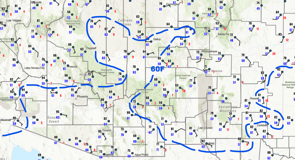
The 60°F surface dewpoint temperatures remain in northern Arizona, with less than 60°F dewpoints in a northwest to southeast swath from western Arizona to the Mogollon Rim. New Mexico is drier, except for the lower elevation to the east near West Texas.
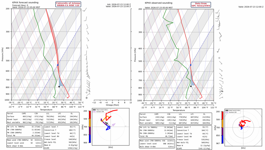
The HRRR-UA WRF 12Z initialization (left) and observed sounding (right) for Phoenix at 5 am are below. Both soundings show a drop in precipitable water with only 1.73″ (32 mm) today versus 1.99″ (50 mm) yesterday.
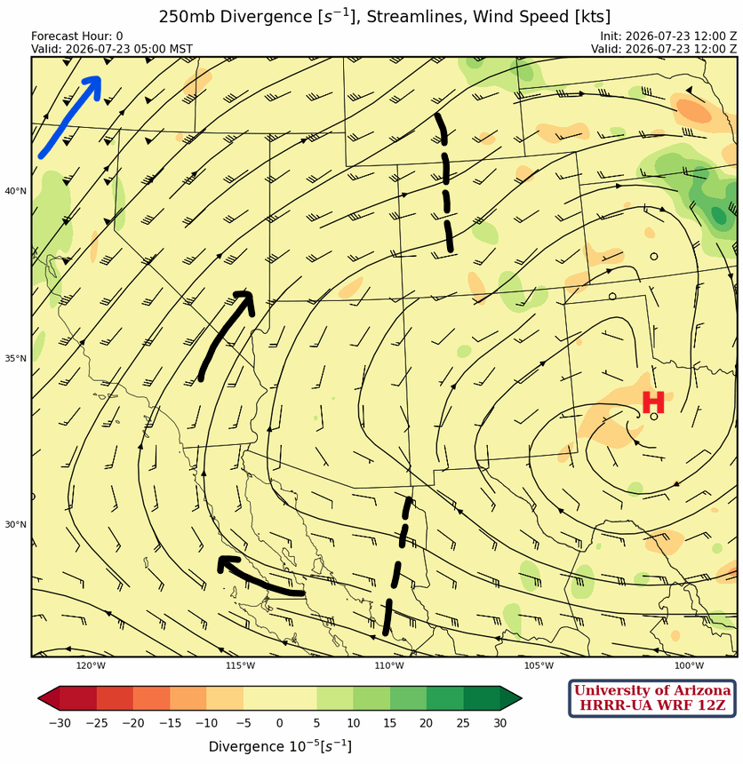
At 250mb, the high-pressure ridge has built a little further into west Texas, and the polar jet is a little further west than indicated. Two short-wave troughs are marked with dashes; the short wave to the north is the remnants of the low-pressure trough in Colorado/Utah yesterday. The short wave in Sonora, Mexico, is underneath the ridge axis and may aid in storm formation along the Sierra Madre mountains.
At 500mb, the trough between the two ridge centers will weaken and allow the subtropical high to be established in the Four Corners region.

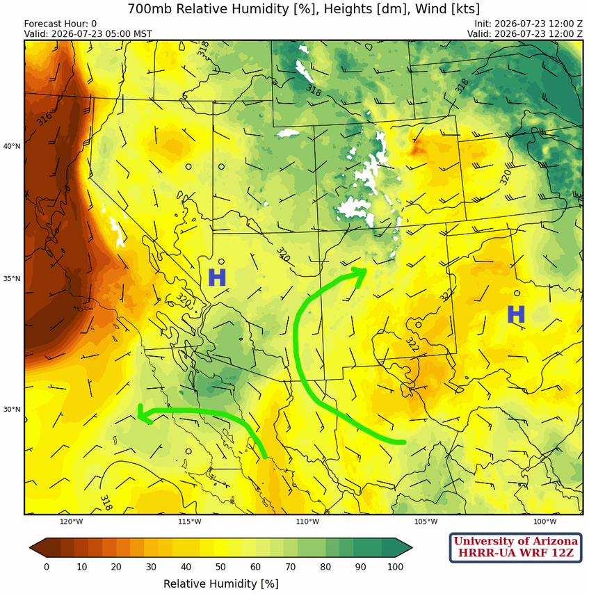
The two high-pressure ridge centers at 700mb will merge tomorrow and set up a more typical monsoon flow.
Today
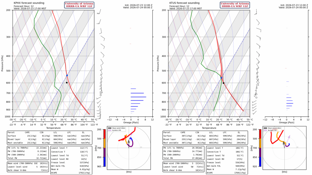
The HRRR-UA WRF 12Z forecast soundings for today at 5 pm show Phoenix has less moisture than Tucson, resulting in no Convective Available Potential Energy (CAPE). The Tucson forecast sounding has enough CAPE for the development of isolated thunderstorms in the mountains. Winds aloft will push the thunderstorms northwest, possibly into the valley, though they will be weakening as they move.
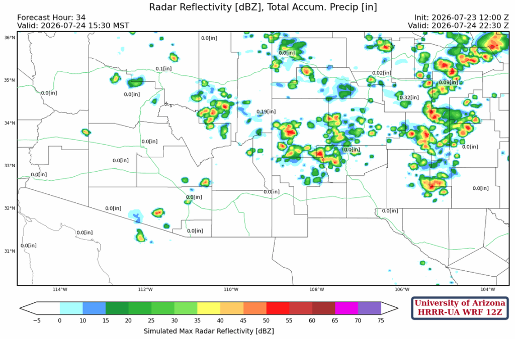
The forecast radar reflectivity shows thunderstorm development in the afternoon and evening. The forecast may have too much areal coverage than is indicated, as there’s not much CAPE in the valley. Thunderstorms should end before midnight.
Tomorrow
The forecast sounding for tomorrow afternoon at Tucson shows CAPE values like today, but CIN is much higher, so thunderstorm formation is unlikely.
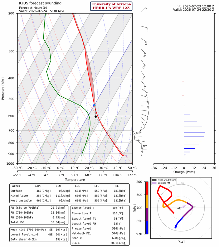
The few thunderstorms forecast in southeast Arizona are short-lived storms. They form over the mountains and dissipate quickly.
Outlook
A gulf surge is forecast for Saturday evening with associated thunderstorm activity and high winds. The timing of surges is hard to predict, as well as the thunderstorm formation resulting from the surge. Some surges cool the boundary layer on the first day, limiting the storms to the mountains; others, like the forecast for Saturday, bring moisture into the low deserts and storms fire that day.
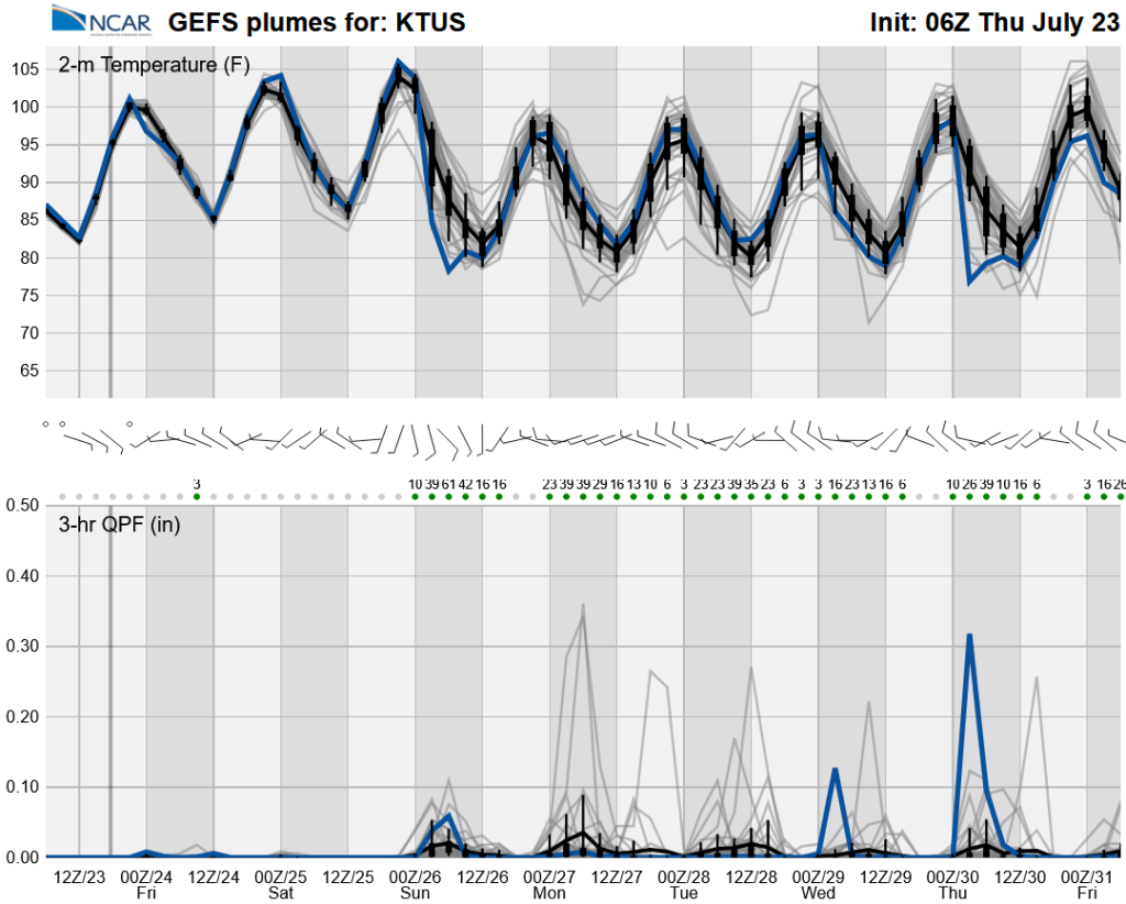
Global model ensemble forecasts agree with the short-term regional models that Friday will be hot and dry. Saturday will be hot again, but chances of rain increase due to the moisture surge from the Gulf of California. The increase in moisture from the surge will bring an uptick in storms next week, though uncertainty remains high, with each day showing chances of rain.
Discussion written by Pat Holbrook and Patrick Bunn