

Summary
Although ample surface moisture is available in Arizona, most areas are unlikely to reach the surface temperatures required for convective initiation, and there isn’t enough mixed-layer Convective Available Potential Energy (CAPE) either. New Mexico remains dry due to the influence of a polar low in Texas.
Forecasts indicate that storm development will be limited today, with only isolated weak storms possible in Tucson this evening and mostly clear conditions expected for Phoenix. Ongoing morning storms are producing light rain and are expected to dissipate by early afternoon, further suppressing additional storm activity.
The outlook for the weekend suggests a decrease in storm activity, with the polar low gradually shifting west into southeast Arizona early next week.
Yesterday’s Weather
Thunderstorms developed yesterday on and near the mountains, but because the wind flow aloft was weak, they dumped much of their precipitation at elevation before weakening and drifting into the valleys. Visible satellite imagery animation for yesterday, with radar overlaid, is below and shows two red dots near Tucson at about 5 pm (00:00 UTC), which were the thunderstorms on the Tucson mountains (west of the interstates) and Catalina mountains (east).
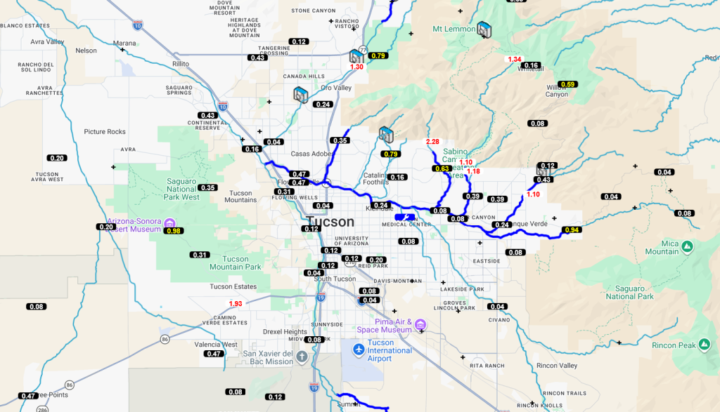
Below is the Pima County Flood Control alert map showing the 24-hour accumulated rainfall from yesterday. The > 1” rainfall was over and near the Catalinas, foothills, and Tucson Mountains, while most of the city of Tucson had less than two-tenths of an inch. More evidence that the winds aloft were weak and did not provide enough push to get the storms away from the mountains.
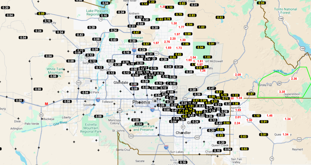
The Maricopa County Flood Control alert map shows that, as in Tucson, thunderstorms produced the most precipitation in the mountains northeast of Phoenix. Further south and west from the mountains, the rain was less, to the point where only a few sprinkles fell in Buckeye and Lichfield Park.
This morning, showers and a few thunderstorms have redeveloped from Phoenix southward into western Pinal and central/western Pima County. Storms are moving slowly eastward and should dissipate later in the morning.
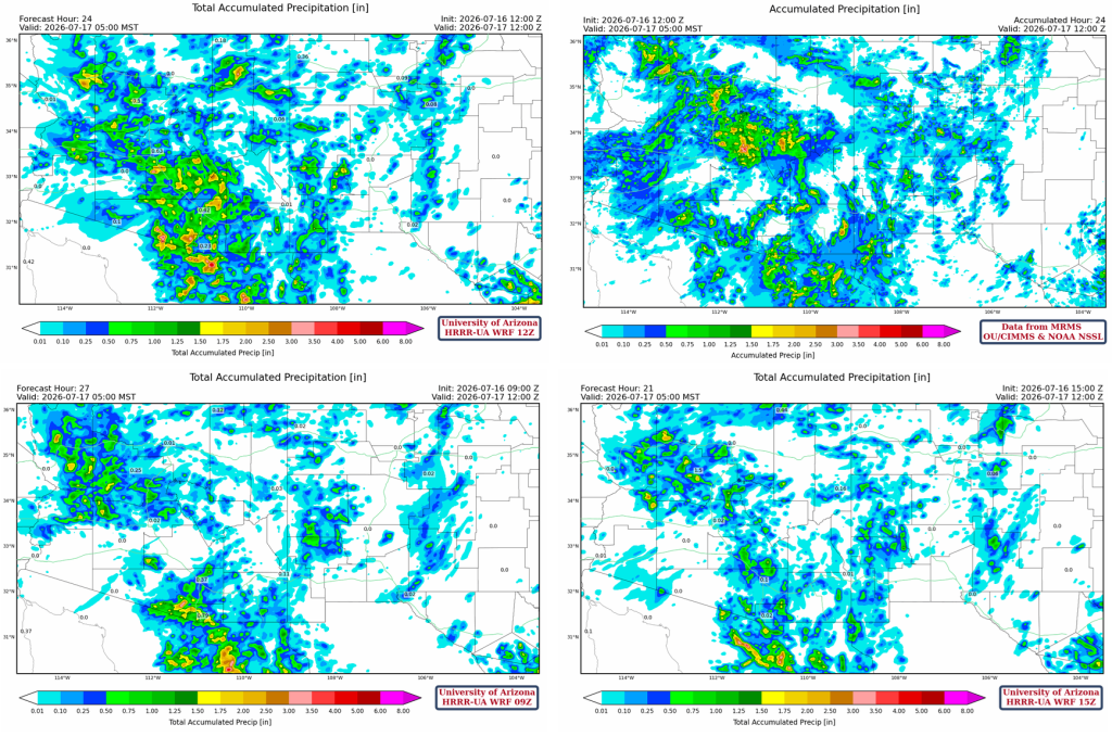
Below is the HRRR-UA WRF 12Z accumulated precipitation forecast through to 5 am this morning (top, left), the corresponding observed precipitation from MRMS (top, right), the 09Z forecast (bottom, left), and the 15Z (bottom, right). At a glance, the 15Z forecast was best for the metro areas, as it predicted less precipitation. Though 15Z underestimated precipitation in the Mogollon Rim and along and south of the international border, compared to the 12Z, which was closer to the observed totals. A typical issue faced with monsoon precipitation forecasts is which ensemble member to trust? This much variability in the forecast leads to uncertainty and a hard message to communicate and interpret, which is most likely going to be wrong in some (or most) places. Hope for the best and prepare for the worst!
Analysis
The low-level water vapor satellite this morning shows the position of the polar low in Texas, the TUTT at the tip of Baja, and Tropical Storm Elida further southwest.
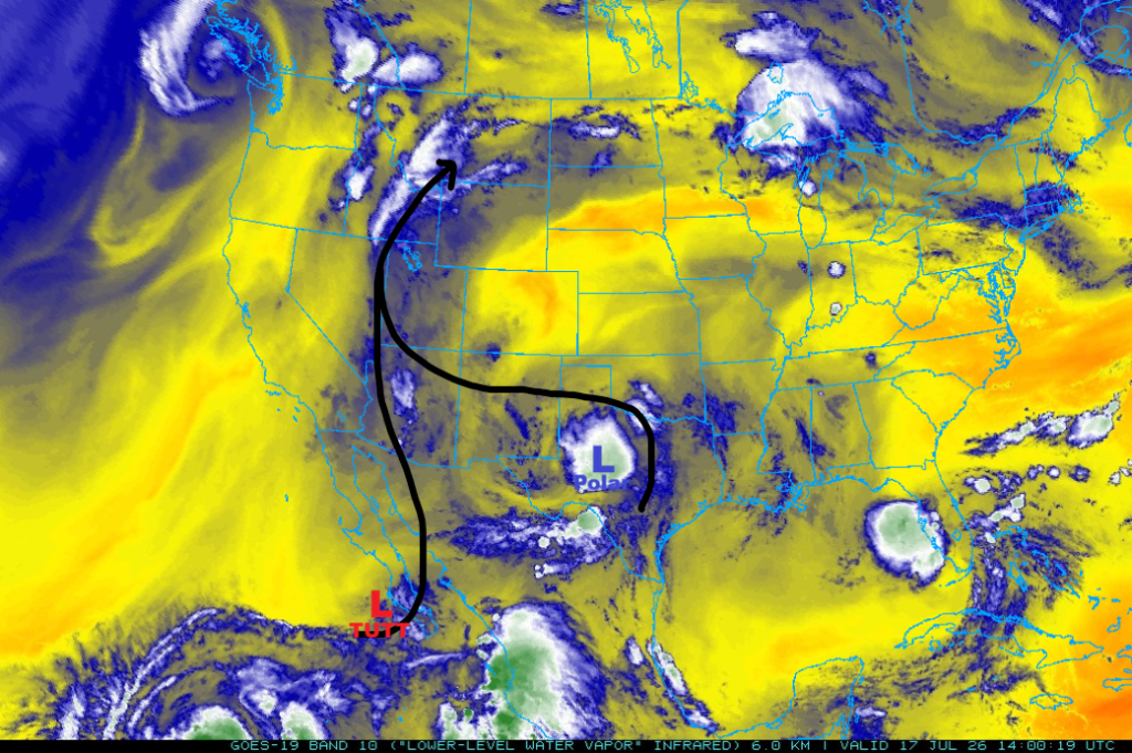
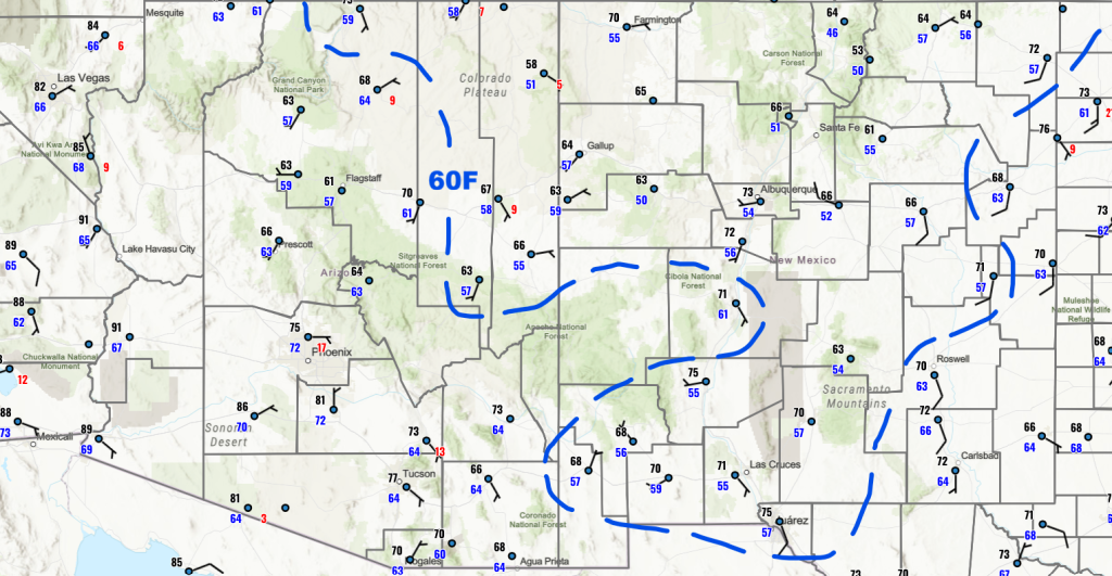
Plenty of surface moisture is available for storms in Arizona, but most locations will not meet the convective temperature for surface-based storms. New Mexico is still rather dry due to the circulation around the polar low in Texas.
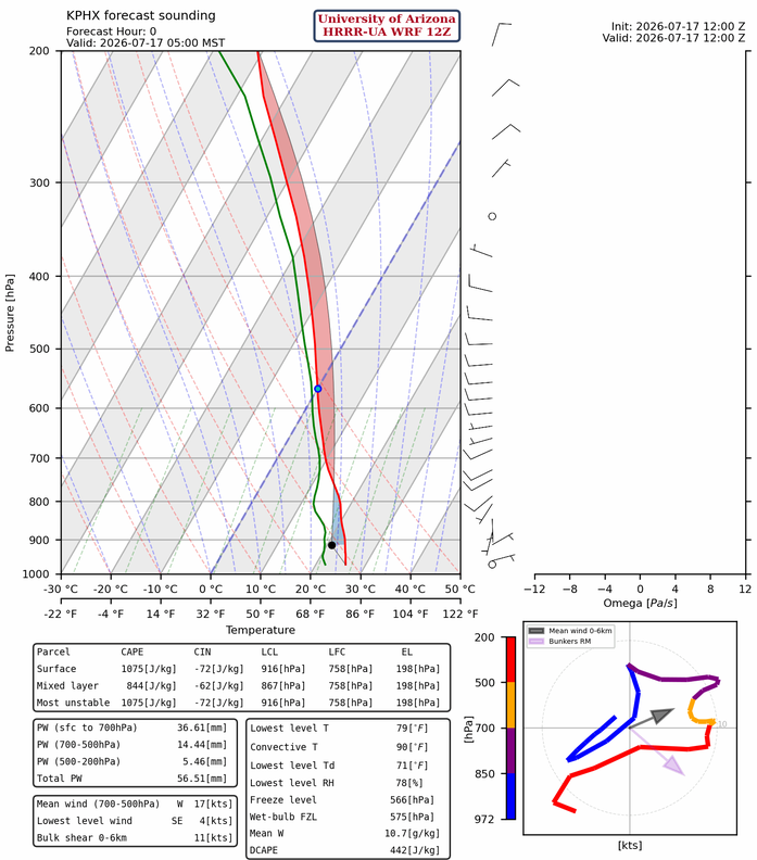
The HRRR-UA WRF 12Z initialization at 5 am is below; the observed sounding was not available today. It will be a challenge for storms to develop this afternoon in either the valleys or the mountains.
At 250mb, there’s not much change in position from yesterday for the monsoon high-pressure, polar low, and trough in the Pacific off the West Coast. The TUTT is just a little further south of its previous location in Baja California, and it’s aiding outflow from Tropical Storm Elida.

At 500 mb, the monsoon flow is now cut off from the easterlies in Mexico due to the circulation around the polar low in West Texas.

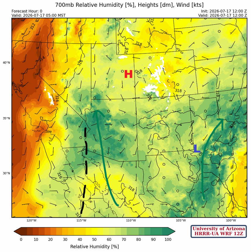
At 700mb, there’s plenty of moisture in Arizona, but southerly winds are bringing in dry air from Sonora. The polar low in Texas appears to be moving further north.
Today
The HRRR-UA WRF 12Z forecast soundings for 3 pm this afternoon in Phoenix (below, left) and Tucson (below, right) do not look too promising. In Tucson, mixed-layer Convective Available Potential Energy (CAPE) is low at 43 [J/kg], and there’s Convective Inhibition (CIN [J/kg]).

The storms shown on the radar as of 9 am this morning are drifting slowly east, producing light rain. Storms are high-based, above 10,000 feet (3 km), and will slowly die off by early afternoon. They will negatively impact convective initiation today by keeping the boundary layer cool.
The radar reflectivity forecasts from both the 12Z and 15Z HRRR-UA WRF are in good agreement. Phoenix will have a mostly clear afternoon and evening, while Tucson has isolated weak storms developing in the evening before ending by 8 pm.
Tomorrow
Tomorrow, there is less moisture, especially west of a line from Flagstaff to Phoenix, then south to Tucson, as mid-level drying at 700mb moves in from Sonora. East of that line, afternoon mountain storms will form, although an isolated cell may move into the valleys.
Outlook
The forecast for Sunday is about the same as on Saturday, with little change in the positions of the monsoon high and the polar low. The polar low has taken on tropical characteristics and will move west into southeast Arizona early next week.
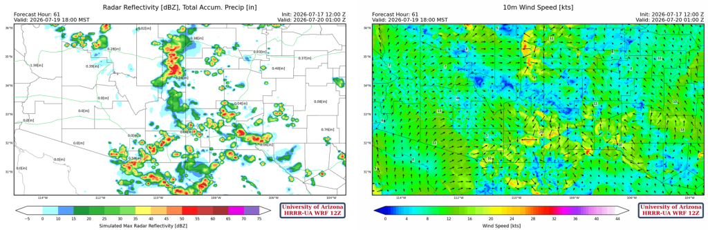
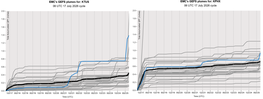
We’re not believing the global model ensemble forecast precipitation today for either Phoenix or Tucson. The UA WRF forecasts nothing at either location, and the light showers in the area will dissipate shortly. After today, the ensemble shows a decrease in activity over the weekend and into next week.
Discussion written by Pat Holbrook and Patrick Bunn