

Summary
Competing pressure systems are influencing the Southwest region: the monsoon high-pressure ridge is over northern Colorado, a polar low is east of Arkansas, and a trough is off the West Coast. While monsoon flow is somewhat cut off by the trough and polar low, Arizona still has enough low-level moisture for storm activity.
Today, thunderstorm activity is expected mainly in the mountains, with valley locations like Phoenix and Tucson unlikely to see storms due to lower temperatures and residual cooling from yesterday’s storms.
Tomorrow, storms are forecast to move into the valleys, with the Tucson valley more likely to be affected than Phoenix due to higher Convective Available Potential Energy, though Phoenix could still get “lucky”. The outlook for the next few days is consistent storm activity, before a slight decrease heading into the weekend. Another uptick in monsoon activity is possible next week if a Tropical Upper Tropospheric Trough moves into Mexico.
Yesterday’s Weather
Quite a busy day as the last of three successive easterly waves enhanced precipitation from southeast Arizona northwest to Tucson, Phoenix, Flagstaff, and Kingman. The low deserts in western Arizona only saw light, if any, precipitation. The combined visible satellite and lightning picture shows the extent of the thunderstorms. On Sunday in Phoenix, an outflow boundary stopped storms from entering the town. Yesterday, the storms rode into town on an outflow boundary combined with the warm, tropical airmass, producing wind gusts in the 45 to 55 mph range and heavy rain.
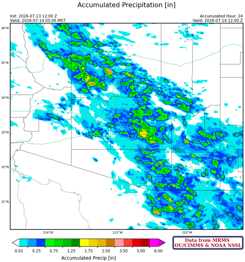
The MRMS 24-hour accumulation observation data for yesterday show that precipitation affected a large area of Arizona, with numerous areas above 0.5” (green) and a few spots in Pinal, Pima, Graham, and Yavapai counties with > 1.5” (yellow).
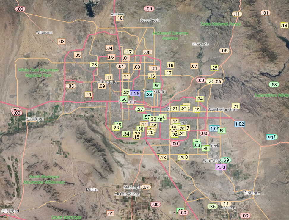
Rainlog data shows the Phoenix Mesa Gateway Airport had 2.3”, but that’s not verified by the MRMS data.
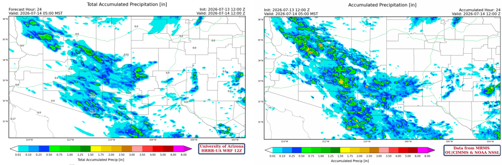
Below is the HRRR-UA WRF 12Z 24-hour accumulated precipitation forecast (left) and corresponding observed precipitation from MRMS (right). Generally, there was an overall underestimation of rainfall, and the forecast favored accumulation over the mountains and did not get the valley precipitation right.
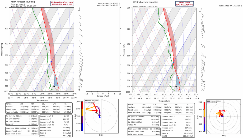
One can speculate as to why, but the missing upper-air sounding data from Tucson was key information needed by the weather models to better understand the vertical profile as the easterly wave approached southeast Arizona. Weather balloon data is valid for approximately 100 km², so the launch in Phoenix isn’t that relevant to Pima, Santa Cruz, or Cochise counties, especially when the flow is from the southeast.
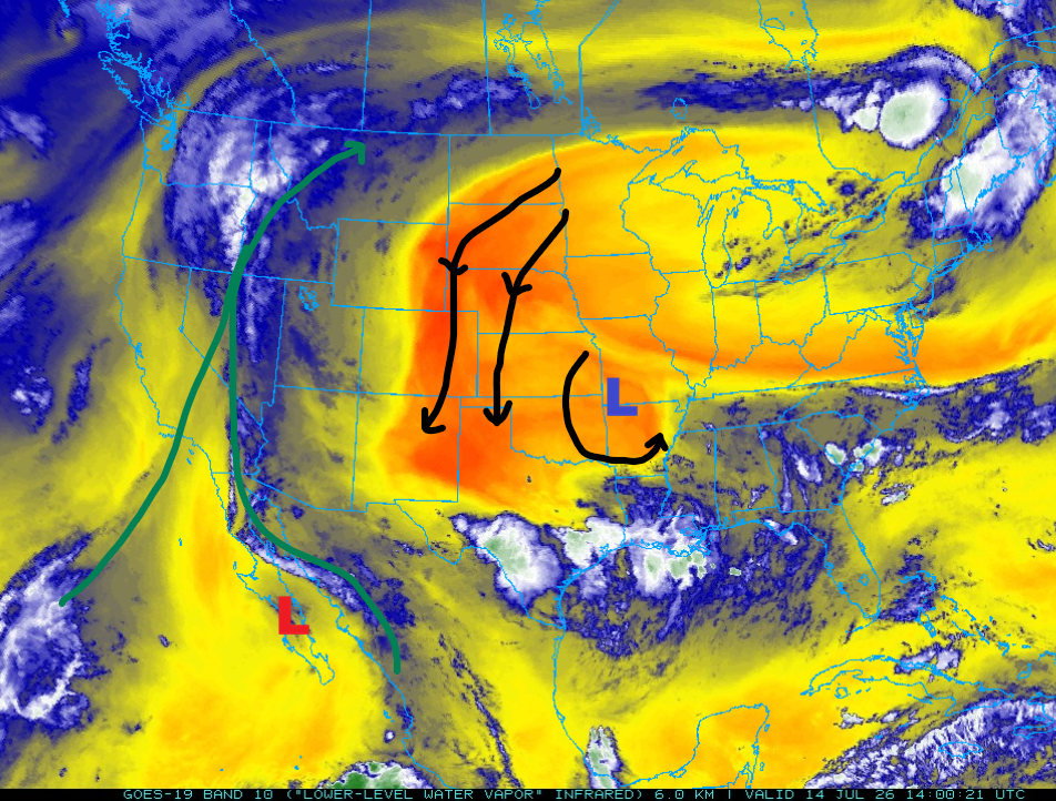
A Tropical Upper Tropospheric Trough (TUTT) is still meandering off the west coast of the Baja Peninsula, and an upper-level polar low has developed over Arkansas, with a large circulation pulling dry air from the north into New Mexico. The polar low is forecast to move to Midland, TX, tomorrow, while the TUTT flow is already changing in response.
Analysis
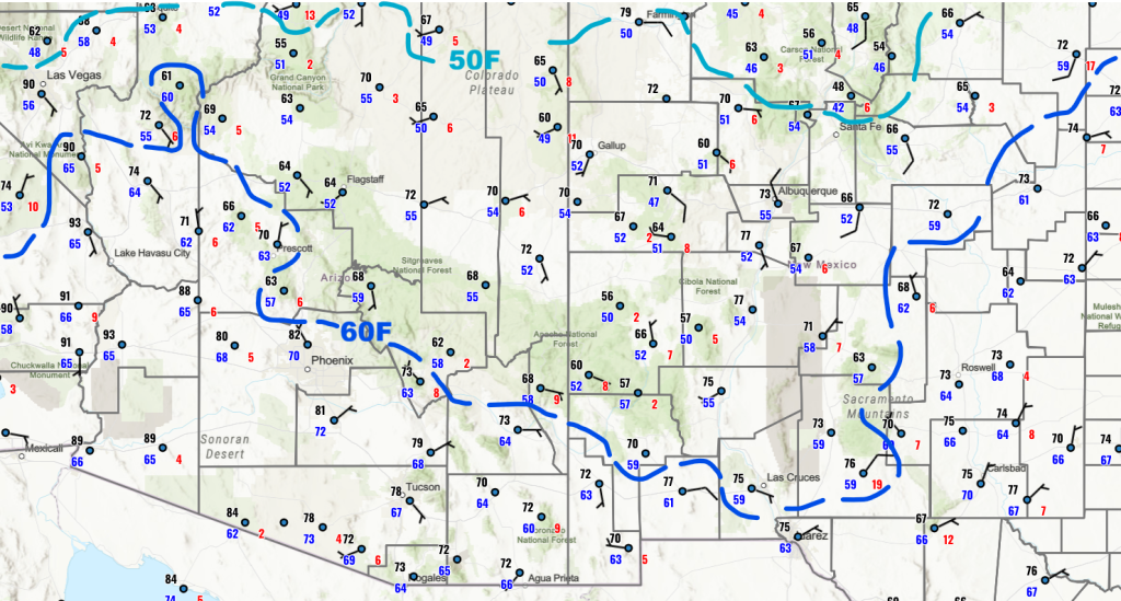
Surface moisture is high across Arizona with 60°F dewpoint temperatures south and west of the Mogollon Rim. Usually, the 50°F dewpoint temperature would define where thunderstorms would form, but the dry air aloft in New Mexico will suppress any storm activity.
At 250 mb, the TUTT along the Baja coast is still just south of the analyzed location, and the polar low is marked east of Arkansas. The high-pressure ridge is over northern Colorado, caught between the polar low and a long wave trough off the West Coast.

At 500mb, the monsoon high-pressure flow over Arizona is being cut off by the wind flow around the Arkansas polar low and the trough off the west coast.

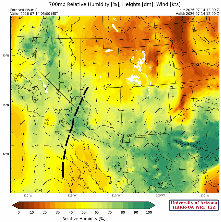
At 700 mb, the third of the three successive easterly waves is moving through western Arizona this morning and will enhance precipitation in that area. Although our monsoon flow has been cut off by the Arkansas polar low, there is plenty of moisture in Arizona to sustain storms as we transition to a flow favorable for Rim Runners, since the monsoon ridge is predicted to elongate and move northwest over the next few days.
Today
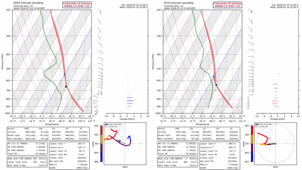
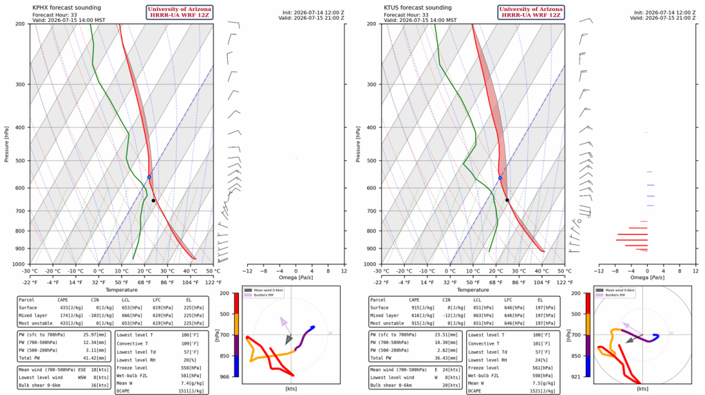
The HRRR-UA WRF 12Z forecast soundings for Phoenix (left, below) and Tucson (right, below) at 3 pm. Both soundings show a decrease in precipitable water, but still enough to support thunderstorms in the mountains. The valleys in Tucson and Phoenix were cooled by yesterday’s storms, so it is doubtful the storms will move far from the mountains today. The high in each city won’t reach the convective temperatures needed: 110°F in Phoenix and 100°F in Tucson.
The HRRR-UA WRF 12Z shows decreased thunderstorm activity today (a down day follows an up day). Thunderstorms form in northern Arizona, along the Mogollon Rim, near the international border, and in northwest New Mexico.
Tomorrow
A Rim shot day! The only question is whether the Phoenix area and its surrounding low valleys have recovered from Monday’s storms enough before Wednesday’s storms move into the valleys. Tucson is more likely to receive storms in the valley because there’s more Convective Available Potential Energy (CAPE), 600 [J/kg] versus 170 [J/kg] in Phoenix.
The radar reflectivity forecast for tomorrow shows storms initiate in the early afternoon on the Mogollon Rim and the Sky Islands of SE Arizona. Thunderstorms move southwest into Phoenix by 6 pm and west into Tucson by 4 pm. In this forecast, the cells appear to miss Phoenix, possibly because the valley has not recovered from prior storm activity. Still best not to discount Phoenix tomorrow, given that a slight misplacement of forecast storms coming toward the valley is possible.
Outlook
On Wednesday, storms are predicted to reach the desert areas west of Phoenix and Tucson later in the evening, from 8 pm onwards. Other storms form in northern Arizona on the Colorado Plateau and move south down the Mogollon Rim.
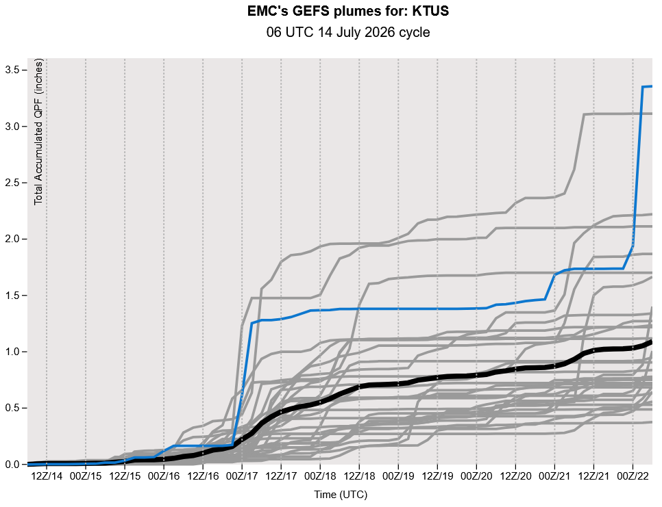
Global model ensemble forecasts show Wednesday night and Thursday to be more active then a slow decrease in storm activity into the weekend. The monsoon ramps up again next week if a TUTT moves west into Mexico next week.
Discussion written by Pat Holbrook and Patrick Bunn