

Summary
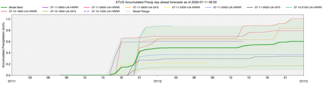
Moisture has increased, and the monsoon ridge has moved to favor easterly flow, bringing unstable conditions, especially to Tucson, which is forecast to experience severe thunderstorms with high winds and heavy rainfall. Phoenix is expected to remain mostly dry today, though mountain storms may send outflows into the valleys. UA WRF forecasts show storms developing in SE Arizona and moving west across southern Arizona, with an ensemble mean precipitation forecast of 0.5″ at Tucson airport, with ranges of 0.25″ to 1.5″ in the Tucson metro possible. There is, therefore, a threat of localized flooding.
Tomorrow, Phoenix will have a higher chance of thunderstorms, while Tucson’s storms are expected to be less severe. By Sunday and Monday, storms will become more scattered and less organized, with a trend toward drier conditions by the following weekend.
Yesterday’s Weather
The satellite imagery with radar overlaid shows that, as of 6 pm Friday evening, thunderstorms were in eastern Arizona, about 30 miles further east than on Thursday. The storms moved west, but dissipated before reaching Pima and Santa Cruz counties. Gusty outflow winds up to 45 mph pushed west into Graham, Cochise, and Santa Cruz counties, but not any further west.
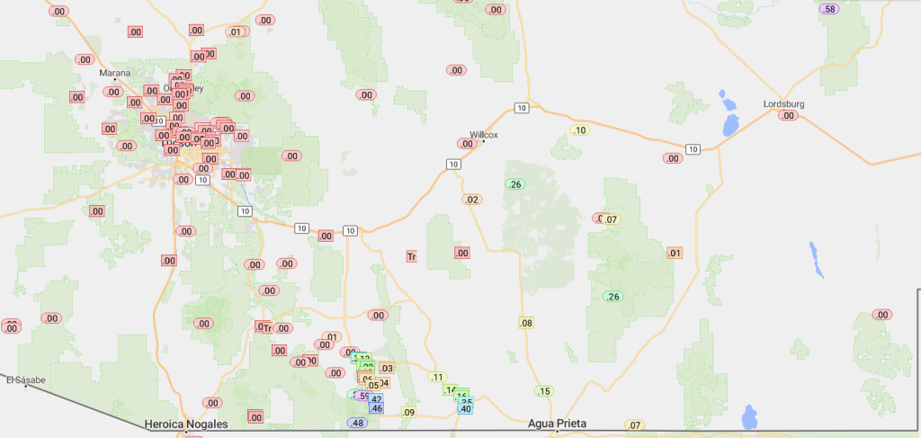
The rainlog data below shows the rain totals from yesterday’s storms.
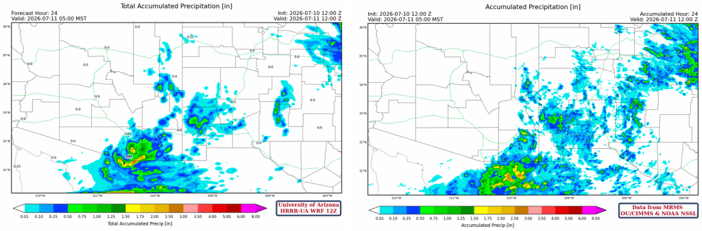
Below is the HRRR-UA WRF 12Z 24-hour accumulated precipitation forecast (left) and corresponding observed precipitation from MRMS (right) for July 10th. Sometimes forecasts are a bust, and this one certainly was! The forecast precipitation was too far east by about 30 to 60 miles in Arizona and was overestimated in central and eastern New Mexico. Why, though? The thunderstorm outflow of moisture into Arizona cooled the boundary layer; Gila Bend was 3°F cooler than Tucson, and Tucson was 2°F cooler than it was at the same time on Thursday afternoon. When the afternoon westerly flow began, the “cool” air from the desert would not allow any cumulus to form even on the mountains. Two degrees does not seem like much, but with a 10,000-foot (3km) boundary layer, the result is a significant reduction in Convective Available Potential Energy (CAPE).
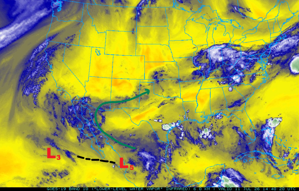
There is a trough axis between TUTT “L3” and “L5”. Over the next few days, these two TUTT lows will merge.
Analysis
Although the 50°F isodrosotherm was in the same general area as yesterday, the 60°F line has retreated further south in Arizona to the international border and further west into eastern New Mexico.
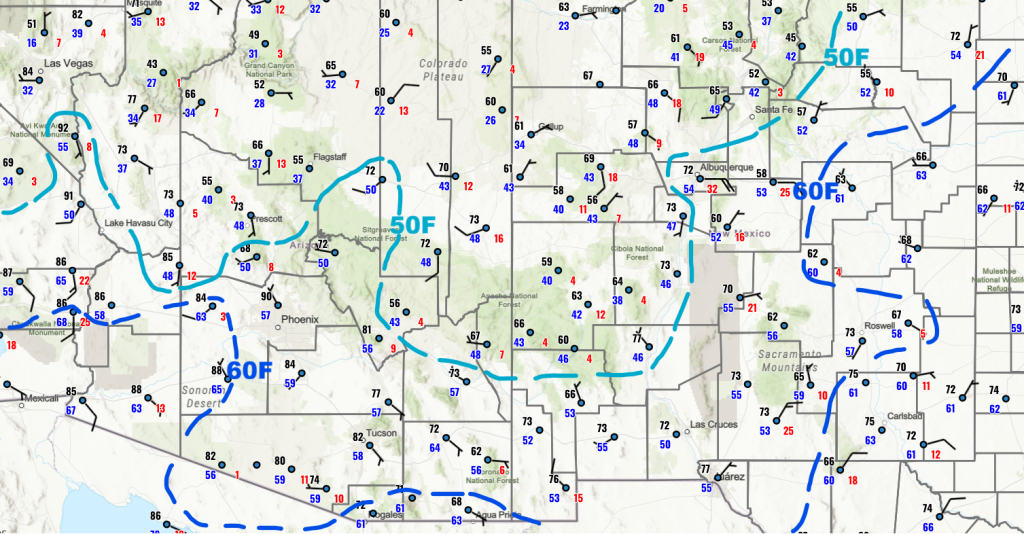
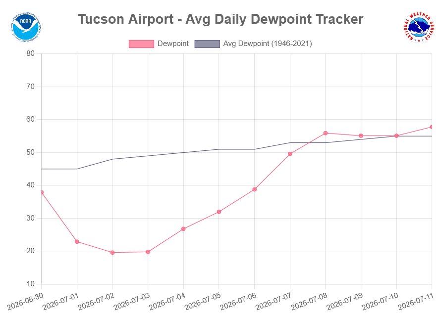
Also, the threshold of three consecutive days with a daily average dewpoint temperature greater than 54°F has been met as of Wednesday, July 8th. This, combined with the change in the predominant wind direction at 500 mb and the precipitable water values, means we’re in the monsoon season now!
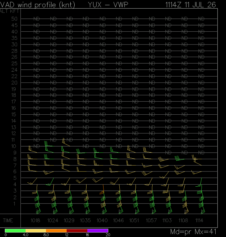
The Velocity Azimuth Display wind profile from Yuma this morning at 4:14 am is below. Another thunderstorm outflow, even higher than Friday, with winds up to 5000 feet (~150 m). Unlike yesterday, this one will not cool the boundary layer since moisture is already present.
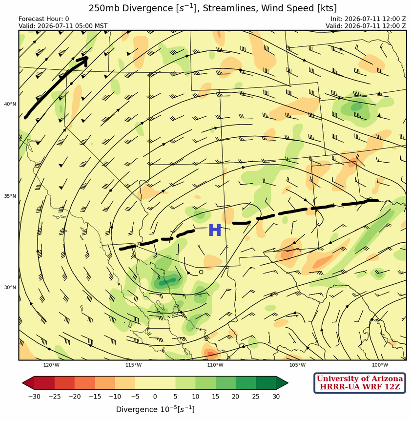
At 250mb, the monsoon ridge has moved into southeast Arizona and is forecast to move north of Phoenix later today, providing an easterly flow across southern Arizona.
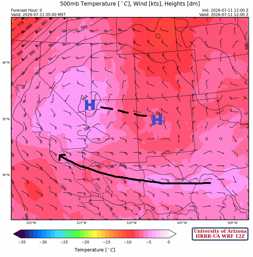
At 500mb, the monsoon ridge is elongated from the Las Vegas area to Santa Fe. A broad easterly flow is well established from south of the ridge axis.
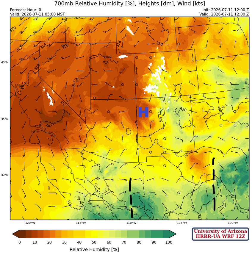
At 700 mb, the Monsoon high has moved into the Four Corners, with a broad east flow from the Big Bend to Southern California. Two easterly waves are as indicated with the best moisture in the Sierra Madre mountain range south of Arizona and in South Central Texas.
Today
Forecast soundings for Phoenix at 6 pm (below, left) and Tucson at 5 pm (below, right) show that Tucson has the most unstable sounding. The skewT for Tucson is a classic thunderstorm sounding, with a combination of severe-weather predictors: 900 [J/kg] CAPE, good wind shear between inflows from the northwest and storm propagation to the southwest, and 40mm of precipitable water. The forecast convective temperature in Tucson is 103°F, which should be reached this afternoon. The predicted hazards include wind gusts and heavy rain. Phoenix sounding still does not support thunderstorms in the valley, and thermal wind is from the east at 5 knots. Thunderstorms on the mountains may produce outflows that lead to precipitation in the valleys.

The forecast radar reflectivity and wind animation below shows storms developing from central Pima County eastward into Santa Cruz and eastern Pima County, as well as Graham and Cochise counties. Pima, Santa Cruz, and Graham counties will have wind gusts up to 60 mph, heavy rain from slow-moving storms, and additional storm development in the evening.
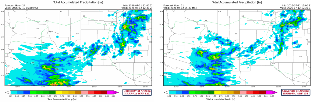
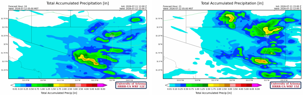
Precipitation totals vary between consecutive runs of HRRR-UA WRF at 12Z (left below) and 15Z (right below). Both have totals above 0.5″ in the Tucson metro area, and the 15Z has totals above 1.5″ extending further east into Pinal County.
The UA WRF ensemble forecast shows ensemble mean accumulated precipitation of 0.5″ at Tucson airport for this event, though the ensemble range is from 0.1″ to 0.85″. There is potential for some localized flooding if the ensemble mean or greater occurs.
Tomorrow
Forecast soundings for Phoenix tomorrow at 3:30 pm (below, left) and for Tucson at 12 pm (below, right) show that Phoenix now has a sounding that can support thunderstorms. 0- 6 km mean wind for Tucson has storm motion at around 15 knots to the west, and Phoenix is at 10 mph, west-northwest. There’s good CAPE and precipitable water, but wind shear isn’t too great with inflows, storm propagation, and anvils all going in the same direction.
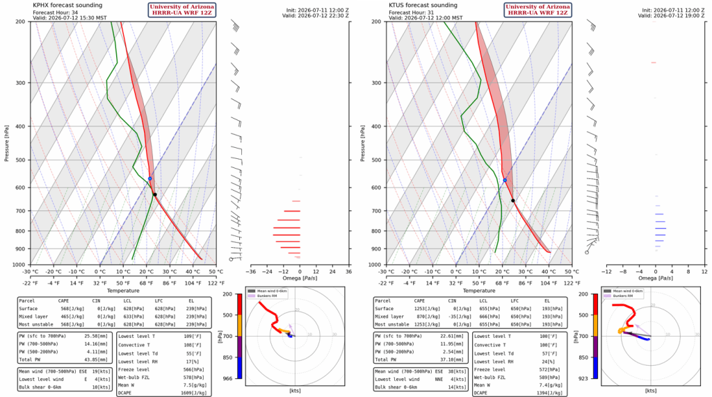
The Tucson storms have lower potential for severity, but storms arriving in Phoenix in the late afternoon will be associated with severe weather as they move all the way to the Colorado River before dissipating. Tucson may see additional storms during the evening.
Outlook
Sunday’s storms will cool the boundary layer for a few days, and storms on Monday will mostly be limited to the mountains and downstream, as the storms will move west-northwest at 15 to 20 mph. Thunderstorms will be more scattered and less organized, meaning localized precipitation.
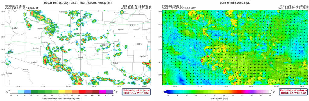
The GEFS global model ensemble indicates that after this weekend, an odd storm or two are expected next week, with some potential drying by next weekend.

Discussion written by Pat Holbrook and Patrick Bunn