

Summary
The monsoon flow in Mexico has been disrupted by a large area of dry air, temporarily halting storms in the Sierra Madre mountains for today into tonight. In Arizona, some moisture remains, but warmer air aloft and significant convective inhibition are preventing widespread thunderstorm development, particularly in central and southern Arizona. Forecasts suggest only light rain for the Tucson metro area tonight, with most storms expected to form in the mountains and southeastern counties. Outflows from storms south of the border are expected to bring strong winds and moisture from the Gulf of Mexico. We’ll write again tomorrow about how this moisture, plus an easterly wave, could ramp up thunderstorms for both Tucson and Phoenix over the weekend. The question is, which day?
Yesterday’s Weather
The visible satellite animation for yesterday, with radar and GLM lightning overlaid, shows that thunderstorms were in the same general location as on Tuesday, with a slight increase in Pima and southeast Pinal Counties and along the international border. Higher dewpoint temperatures helped create stronger storms than yesterday, but the storms generally stayed close to the mountains. Observed wind gusts were up to 54 mph along the Tucson foothills and 74 mph at Sells in central Pima County.
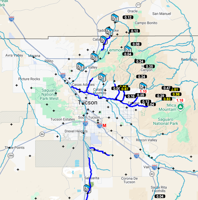
The Pima County Regional Flood Control District observations below show a pattern similar to Tuesday, with the heaviest rain in the eastern part of the county, along and in the mountains. Mica Mountain, in the Rincon Mountains, was the winner with 1.18″. No significant blowing dust was reported.
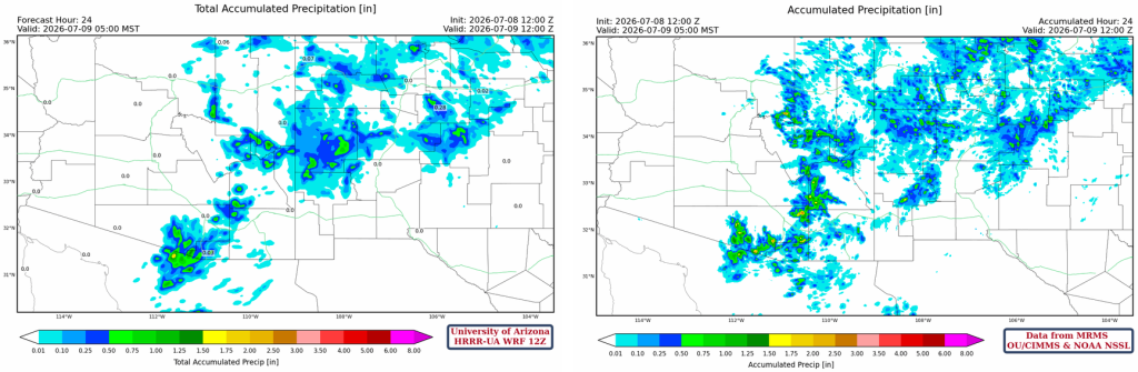
Below is the HRRR-UA WRF 12Z 24-hour accumulated precipitation forecast (left) and corresponding observed precipitation from MRMS (right) for yesterday. The observed precipitation is a little more than forecast, especially in eastern Pinal County, with more widespread areas above 0.5″, but the overall pattern of forecast precipitation is good.
Analysis
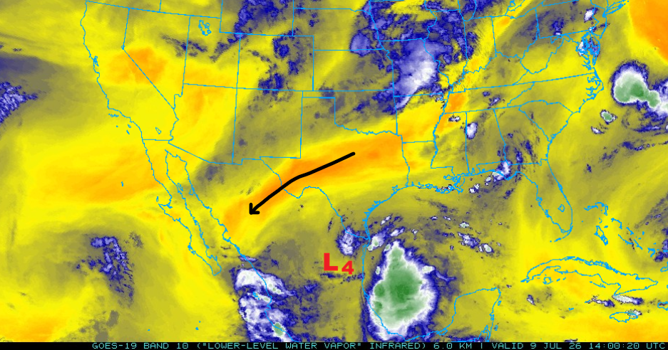
Low-pressure systems “L3” and “L5” have moved and are no longer affecting the monsoon flow, while the TUTT low “L4” has reformed farther north in central Mexico. A large area of dry air cut off the monsoon flow; although temporary, this will stop the monsoon storms in the yellow and red areas in the Sierra Madre mountains.
The 50°F and 60°F isodrosotherms remain in about the same locations as yesterday.

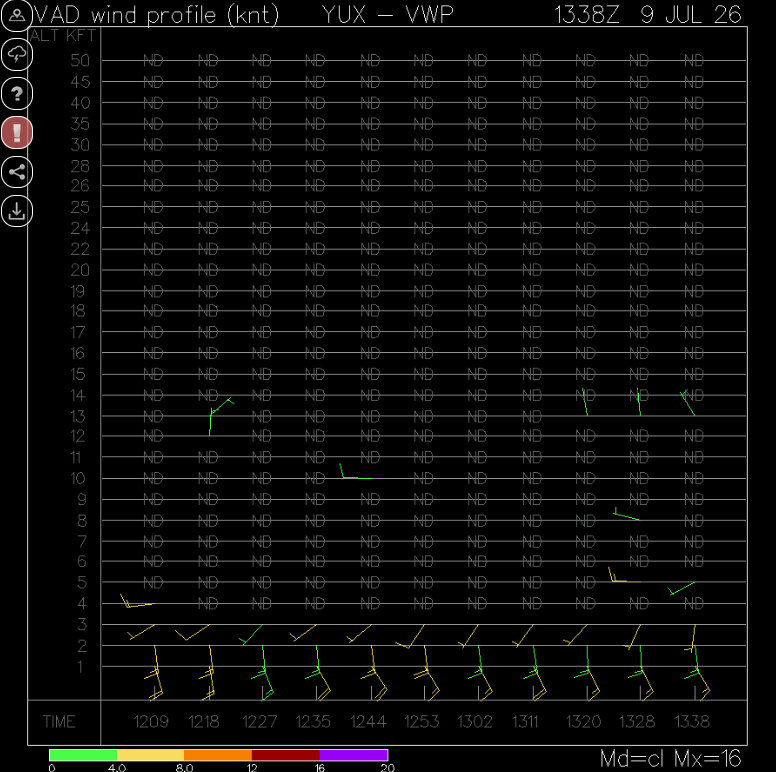
The Velocity Azimuth Display wind profile from Yuma below shows low-level southerly winds, but the replacement moisture may have been cut off as profiles earlier in the morning had westerlies just above the surface. The thunderstorm outflow this morning was from weaker storms last night, whereas much stronger storms generated the Wednesday morning moisture push.
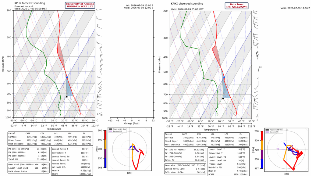
The observed sounding from Phoenix at 5 am (below, right) has 2mm less precipitable water than yesterday at 34mm (1.3″). There’s some Convective Available Potential Energy (CAPE), but a lot of Convective Inhibition (CIN) due to warmer temperatures aloft and the boundary-layer temperature profile. Mixed-layer CIN is greater than CAPE, which will cap storms.
At 250 mb, the polar jet stream is in roughly the same location as yesterday. The monsoon high is centered over the northern Gulf of California and is being squeezed by the circulation around TUTT lows “L3” and “L4”.

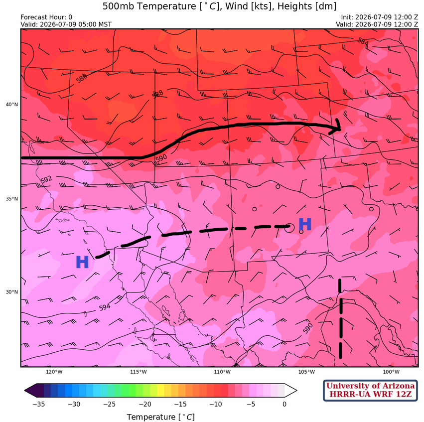
Warmer air has moved into the area at 500 mb, which will inhibit thunderstorm development, as most of Arizona is above -5°C; only eastern Arizona will be cool enough at 500 mb to support deep convection (Apache, Greenlee, Graham, and Cochise counties). The monsoon high is off the California coast and extends eastward to a second center in southeast New Mexico. The eastern part of the monsoon high has moved slightly further south and is bringing more northerly winds into southeast Arizona. An easterly wave is near the Big Bend and is moving slowly west. The easterly wave could aid in the thunderstorm development as it approaches over the next few days, increasing baroclinicity and lift.
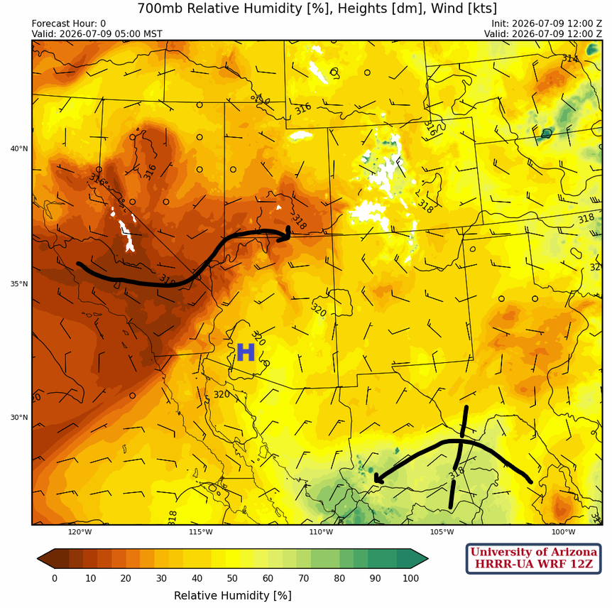
700mb: The monsoon high is in southwest Arizona with dry air wrapping around the ridge in northern Arizona…and although we are dry in southeast Arizona the storms will form again in the Sierra Madre’s and moisten that area along with the flow around the easterly wave.
Today
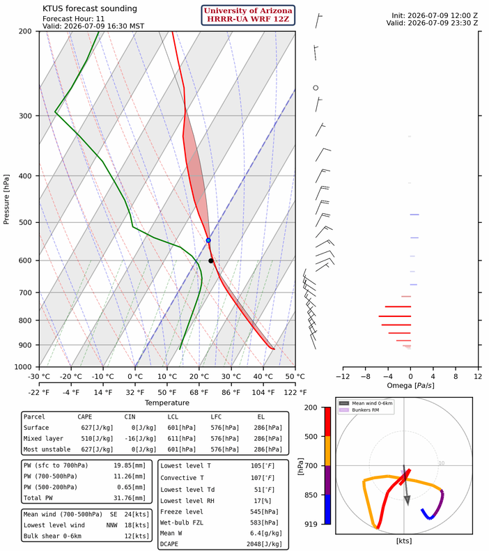
The 12Z HRRR-UA WRF forecast sounding for Tucson at 4:30 pm this afternoon is below. There are things to like and not like. There are light southeast winds in the boundary layer and northerly winds aloft, indicating storm propagation is to the south-southeast, so conditions are still not favorable for the Tucson metro. Precipitable water is a tad less than yesterday, but still enough, and the thermal wind is from the north (black arrow below right). It’s not that there won’t be storms, but they will, once again, miss the Tucson metro area, staying closer to the mountains.
The first storms are forecast further southeast in Cochise and Santa Cruz counties this afternoon, and then outflows move in from the southeast, creating storms that move toward the Tucson metro area. These storms will be weaker, with outflow wind gusts of less than 45 mph.
Only light rain is expected in Tucson, less than 0.25″ for the metro area.
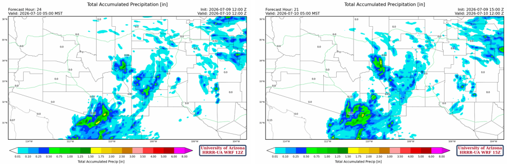
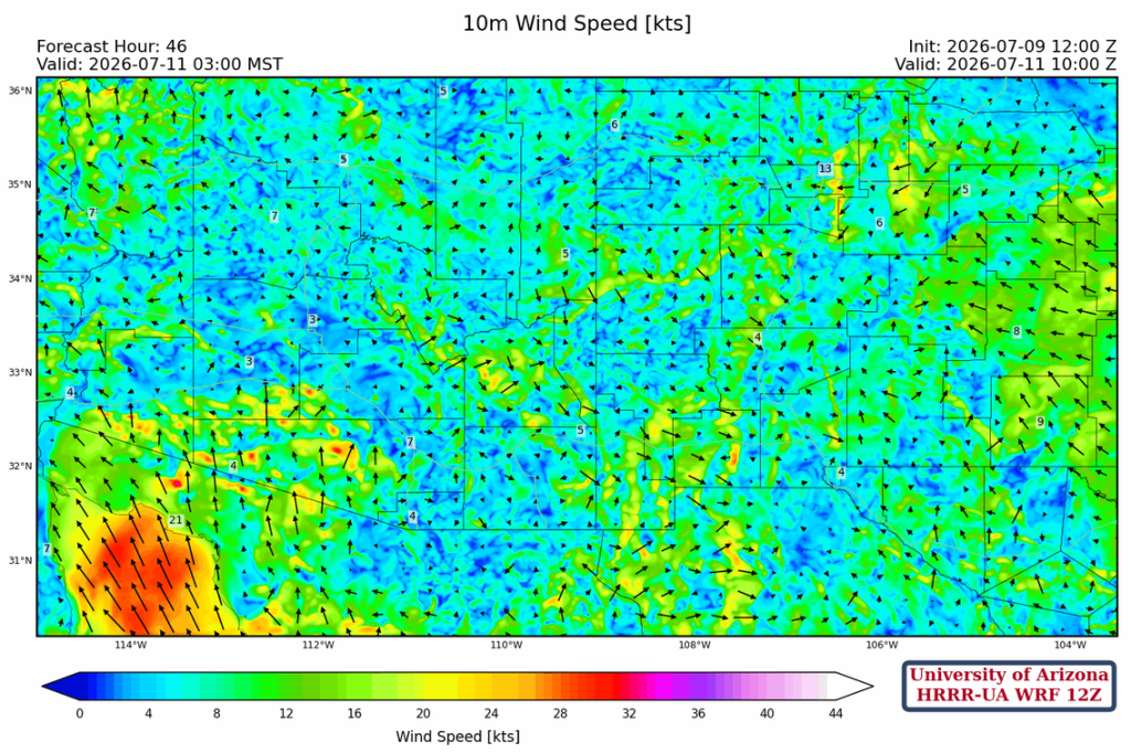
Thunderstorms south of Nogales push westward towards the Gulf of California and produce strong outflow that, by morning, moves into southwest Arizona. Watch for strong winds in the forecast loop at about 3 am.
Tomorrow
The forecast sounding for Tucson tomorrow at 6 pm shows more easterly flow above the boundary layer, suggesting a west motion for storms. Outflow from thunderstorms in the boundary layer should overcome the CIN in the evening.
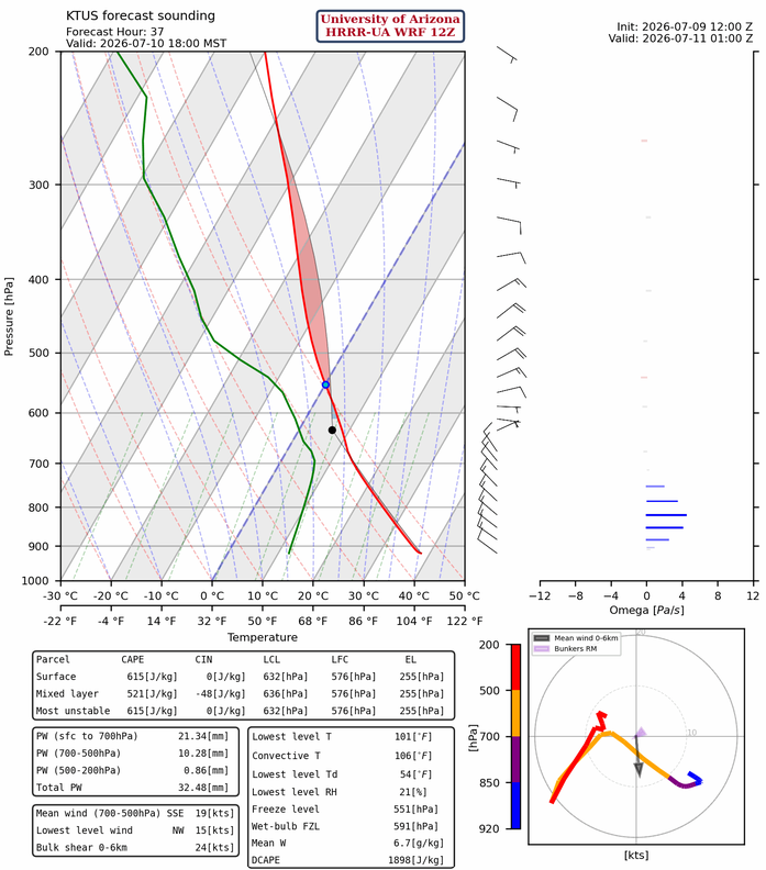
Friday’s forecast is very similar to Wednesday’s storm positions, except slightly further east. The outflows will reach Tucson in the late evening, but any storms will be light and short-lived. The interesting part is that storms south of the border, like tonight’s activity, will generate an even stronger outflow moving west toward the Gulf of California.
Outlook
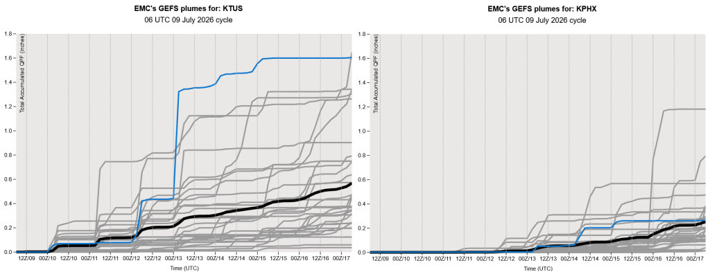
The global model ensemble, GEFS (below), shows considerable variability among its members. This is typical once the monsoon’s moisture moves into the state, highlighting the importance of daily forecasts, as the outlook changes from day to day. We’re looking ahead at the weekend forecasts, but we’ll wait until tomorrow to comment further when we can see the latest forecasts and assess the trend compared to today.
Discussion written by Pat Holbrook and Patrick Bunn