

Summary
Over the past several days, moisture levels have increased in Arizona, with the 50°F isodrosotherm moving northward and westward, contributing to thunderstorm development. Weather balloon observations show rising precipitable water, and satellite imagery shows patchy thunderstorm activity, especially in mountainous areas. Widespread storms remain limited due to the lack of organization of monsoon flow.
Today, isolated storms are expected in the mountains, but most of the low desert will remain dry. Tomorrow, increased moisture and instability will bring more widespread thunderstorms and blowing dust, especially around Tucson, while Maricopa County will likely stay dry. Through Thursday, storms are forecast to form primarily in the mountainous areas in the Tucson area, with outflow boundaries aiding development in the valleys. Dewpoint and precipitation forecasts indicate a continued trend of increasing moisture into the end of the week, with Thursday night into Friday looking more like the meteorological start of the monsoon season.
Yesterday’s Weather
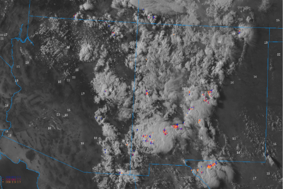
Thunderstorms developed in the White Mountains, much of Graham County, and the western half of New Mexico. The visible satellite, wind gusts, and lightning composite show the main areas of activity at 5 pm yesterday. Microbursts were not that strong, generally less than 40 mph, mainly due to low precipitable water values. The dry air aloft moving south behind the low-pressure system in Oklahoma resulted in mostly clear skies over the lower elevation; eastern New Mexico and west Texas.
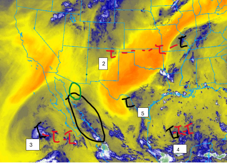
The upper-level low-pressure system, “L2”, is exiting the region and, except for the dry air over west Texas and eastern New Mexico that limited thunderstorms, it has not been much of a factor. Low “L3” is moving slowly west and has been responsible for the divergence aloft along the Sierra Madre in the area in black. Deep convection has been firing each day in this area, with the strongest storms a couple of hundred miles further north. The area marked in green should be the location of strong storms today. Low “L4” is drifting west in the southern part of the Gulf of Mexico, and low “L5” has formed.
Analysis
Over the past few days, the 50°F isodrosotherm (line of constant dewpoint temperature) has moved further north and west into Arizona, advancing and retreating each day. This is partly due to mixing from thunderstorms, and the moisture will help initiate thunderstorms again today.

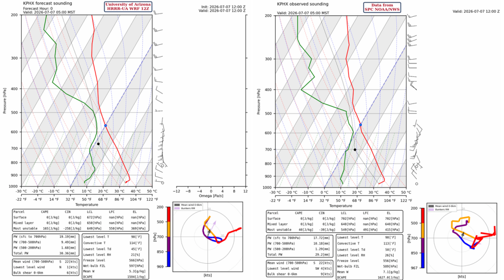
The observed weather balloon sounding in Phoenix at 5 am shows an increase in moisture in a layer between 600mb and 480mb; the precipitable water increased to 29mm (1.15” ). Winds are southerly below the moisture layer. Given the amount and vertical distribution of moisture, storms can form in the mountains but not in the low deserts. The HRRR-UA WRF 12Z initialization matches the observed precipitable water, moisture and wind profile. A touch too much moisture in the boundary layer of the forecast initialization.
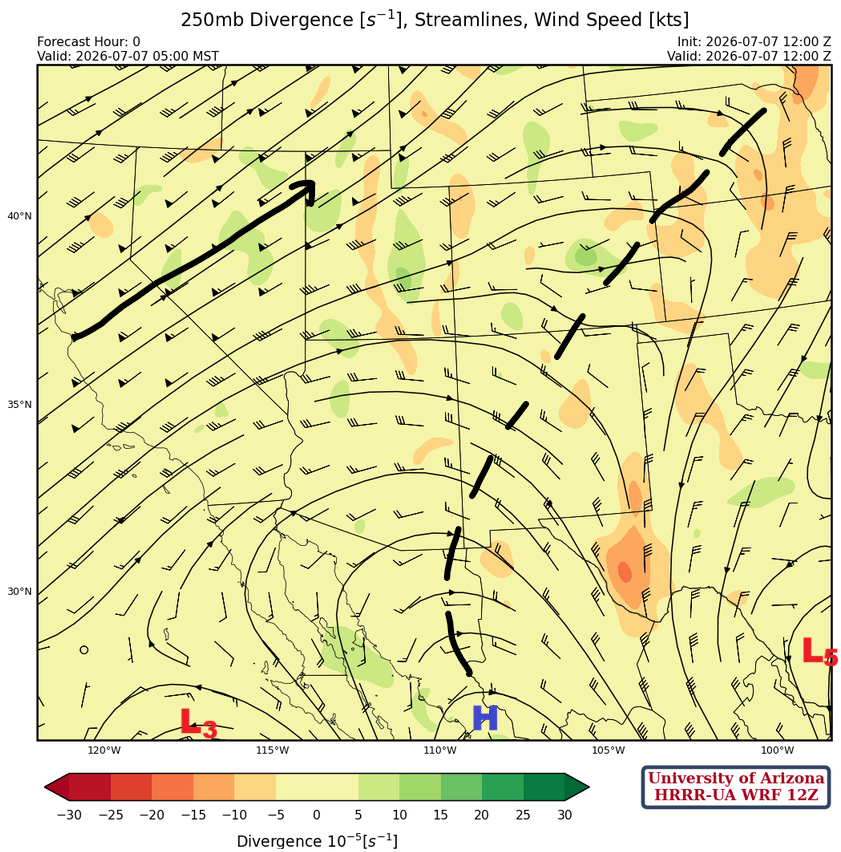
At 250 mb, the upper-level lows “L3” and “L5” are just on the edge of the forecast initialization below, along with the monsoon ridge (subtropical high pressure) in the middle. The ridge axis extends northward, then northeastward into Nebraska.
At 500 mb, the monsoon ridge is just south of the four-corner region, with an upper-level low forming near Eagle Pass, Texas.

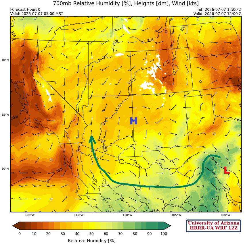
The monsoon flow pattern is getting a little better organized at 700 mb, but still not strong enough today to support widespread storms.
Today
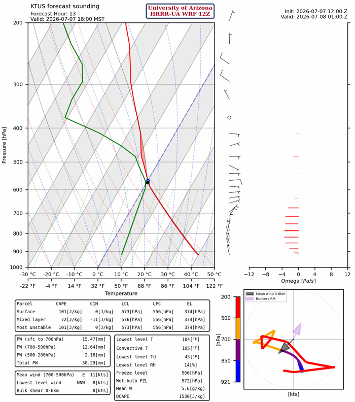
The forecast sounding for Tucson at 6 pm today is below, and there’s barely any Convective Available Potential Energy (CAPE). Any storms forming on the mountains that could produce microbursts won’t be large enough to create widespread blowing dust.
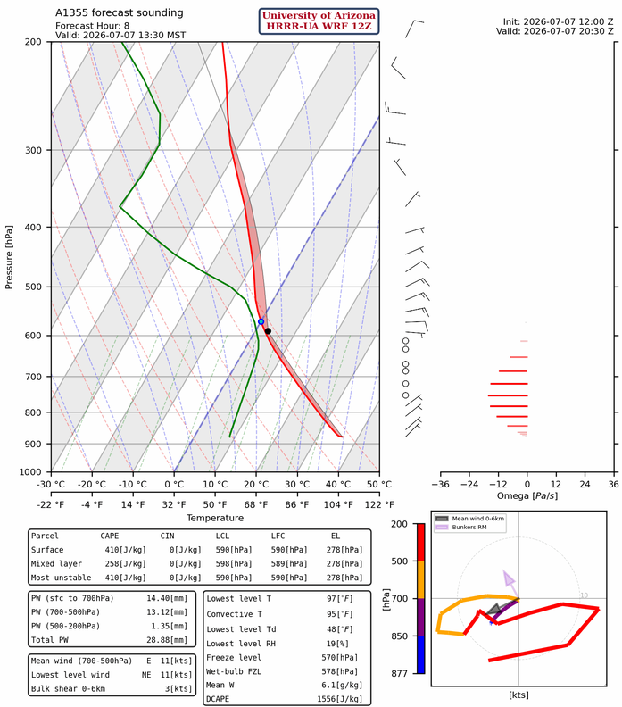
The Nogales forecast sounding for 1:30 pm has more CAPE with storms forming in the early afternoon. Wind gusts up to 40 mph are possible with these storms, with some localized blowing dust.
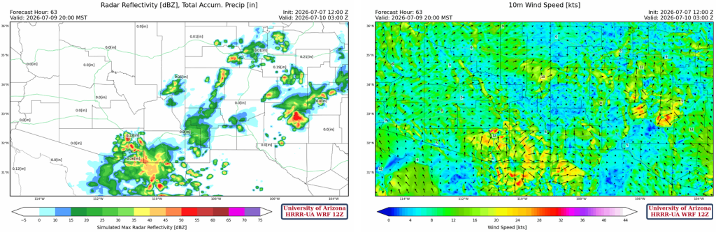
The HRRR-UA WRF 12Z forecast radar reflectivity shows that storms form early in Santa Cruz County and move southwest. Convective initiation will be later in the afternoon for the Tucson area mountains.
Tomorrow
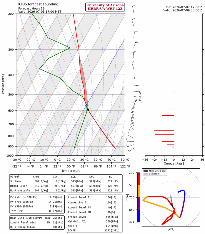
Precipitable water values increase to 34mm (1.4”) in Tucson, and there’s more forecast CAPE, meaning more widespread thunderstorms and blowing dust tomorrow.
Thunderstorms will initiate in southeast Pinal County, and storm motion will push storms off the mountains southwest into the Tucson area. Maricopa County will still not have storms.
Outlook
On Thursday, storms form later in the day in the Tucson area and are generally weaker. Outflow boundaries appear to be the forcing mechanism for storms in the valley, as storms aren’t strong enough to move out into the low desert without them, given low mixed-layer CAPE and borderline precipitable water.
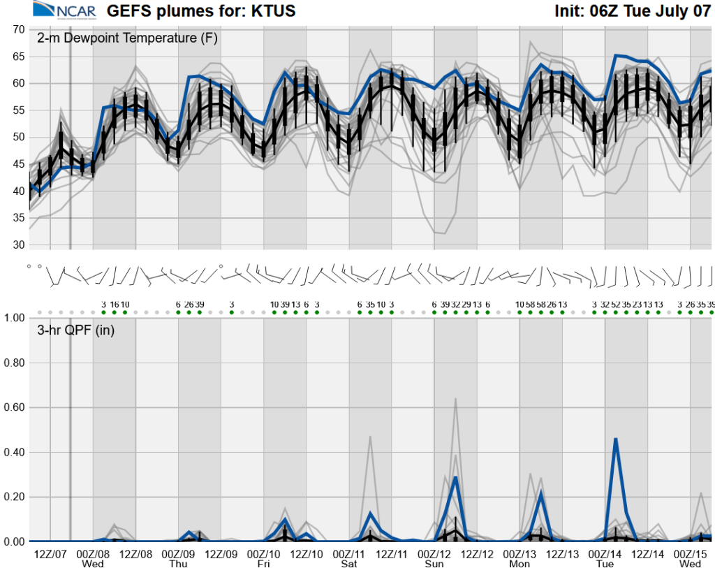
The GEFS ensemble forecasts for 2-meter dewpoint and 3-hour accumulated precipitation are shown below through Wednesday next week. Don’t be fooled by the 3-hour precipitation values; the y-axis scale on the left now goes up to 1 inch, up from half an inch on yesterday’s forecast plot. Dewpoint set to exceed the 54°F threshold in Tucson on Friday.
Discussion written by Pat Holbrook and Patrick Bunn