
Summary
A broad trough moving into the Pacific Northwest has increased moisture transport from the Gulf of Mexico into New Mexico. Soundings from Phoenix indicate mid-level moisture and low microburst potential, with models overestimating precipitable water. The jet stream currently favors severe weather in the Midwest, while the monsoon ridge will shift westward in the coming days, influencing moisture and storm development in the Southwest.
Today, storms are expected mainly in northeast Arizona and western New Mexico, with low microburst potential and limited precipitation. Tomorrow, moisture shifts toward Tucson and northern Arizona, producing mainly mountain storms that are generally weak due to limited available moisture. By Thursday, storms move east and remain confined to mountainous regions, with little rainfall expected overall.
The primary risk during this period is lightning-caused fires in the mountains. Predicted lightning strikes in the Chiricahua and Rincon Mountains likely will have insufficient rain to extinguish potential fires.
Longer-range forecasts suggest increased monsoon activity in Tucson at the end of the month, though confidence in these predictions remains low. The latest model guidance and observed data highlight the ongoing pattern of limited moisture and the associated fire risks in the Southwest.
Yesterday’s Weather
Below is an infrared satellite showing monsoon thunderstorms in northwest Mexico. The thunderstorms have dissipated overnight, with the remaining moisture moving northward into western Arizona. None of that resultant moist air is at the surface yet.
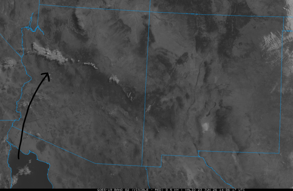
So how about the monsoon? Right now, a trough is moving into the Pacific Northwest, and the broad low-pressure circulation associated with it will allow mid-level moisture to move from Mexico into Arizona. This will result in isolated high-based thunderstorms in western and northern Arizona today, especially along the Mogollon Rim, and will spread into the rest of Arizona through Friday. There is not enough moisture for wetting rain, and dry lightning is the main threat. As the trough moves eastward into the Great Plains next week, the monsoon ridge will move northward into Arizona, closely followed by monsoon moisture during the first week of July (the arrow annotated above shows the direction of flow, translated to the east over the next week)
It will be iffy whether we reach the “magical” three-day average dewpoint temperature of 54°F per the NWS definition of the monsoon start for Tucson (55°F for Phoenix). Still, it doesn’t make much difference since thunderstorms will be here anyway, and the subtropical high (monsoon ridge) is just to our south with Mexico in a North American Monsoon pattern.
Analysis
The 50°F dewpoint isotherm (line of constant temperature) is along the Mexican border. In eastern New Mexico, moisture from the Gulf of Mexico has increased in response to a trough in Colorado.

The observed weather balloon sounding from 5am in Phoenix (below, right) shows that mid-level moisture is between 520 mb and 680 mb. Storm motion on the Mogollon Rim should be to the northeast with little to no directional wind shear. Downward Convective Available Potential Energy (DCAPE) is 784 [J/kg], meaning microburst wind gust should be the square root of that value, so less than 30 knots. Precipitable water in the HRRR-UA WRF 12Z forecast initialization (below, left) is too high at 22mm, more than double the observed value of 10mm!

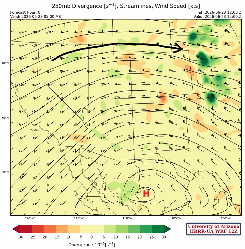
At 250mb, the jet stream extends from northern California to Nebraska. This pattern is a significant severe weather pattern for the Midwest and is already producing severe thunderstorms in that region. The monsoon high is located west of Chihuahua, Mexico, and will drift westward over the next few days as the Pacific Northwest trough drops into the Great Basin by Thursday. The trough will deepen and maintain its relative position by the weekend, pushing the monsoon ridge to the southern tip of the Baja Peninsula. Next week, the trough is expected to move east, and the monsoon ridge to the Four Corners region.
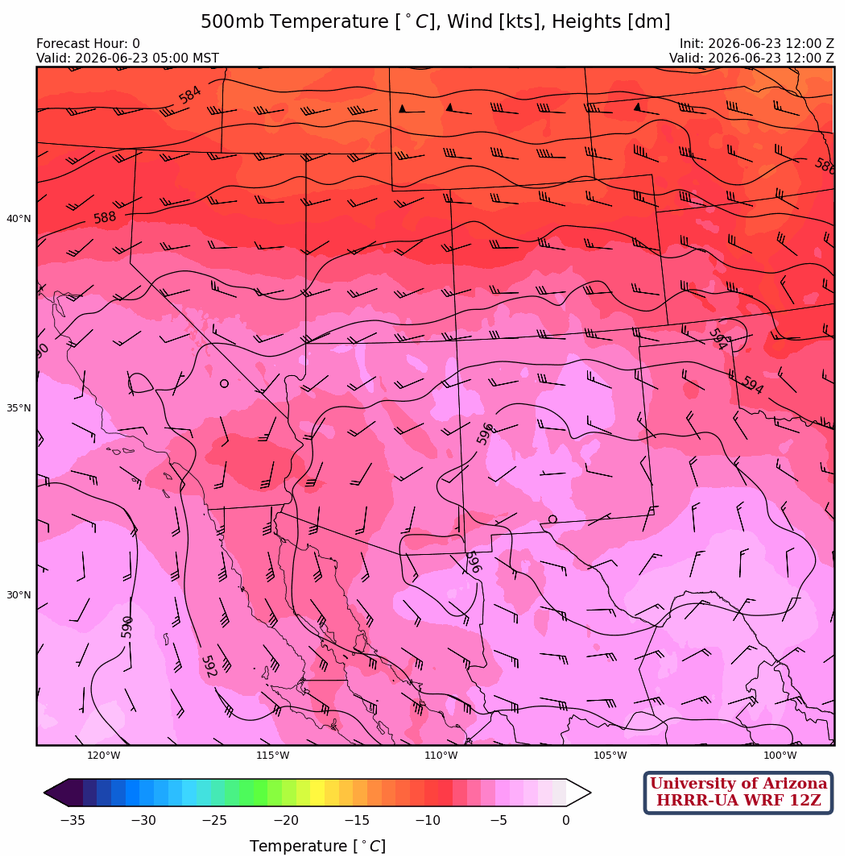
At 500mb, the monsoon ridge is over El Paso this morning with winds aloft at 10 to 20 knots from the south and southwest. Temperatures have warmed from last week’s values, a little too warm perhaps. The -10°C to -5°C range would be better.
The 700 mb ridge is in about the same location as the 500mb ridge, with easterly flow south of the ridge axis and westerly winds to the north. The moisture flow around the ridge is shown with the green line, but there is not much moisture to work with.

Today
Forecast SkewT soundings for Tucson (left) and Prescott (right) at 3:30 pm are below. Some Convective Available Potential Energy (CAPE) is available in Prescott, with cloud bases around 12,000 feet, but precipitable water values are low across both locations (< 23mm).

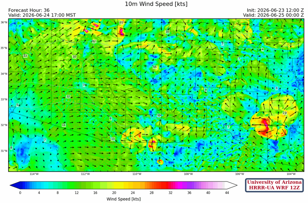
By afternoon, the main area of storms is in northeast Arizona and western New Mexico. Note that the microburst potential is low.
Overnight storms form further west, but there is not much in the way of total precipitation.
Tomorrow
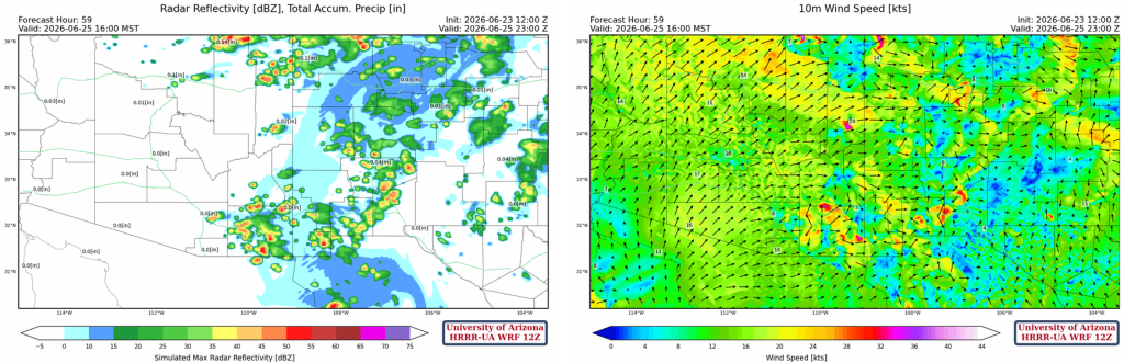
The moisture flow shifts to the Tucson area, then into Cochise County, and finally into the northern portion of Arizona. Most of the thunderstorms will be in the mountains, and they seem to be small cells due to the lack of abundant moisture.
Some stronger downdrafts are associated with the storms that form in southeast New Mexico.
Outlook
Less moisture is available on Thursday, and thunderstorms shift eastward. Storms again will be confined to the mountains.
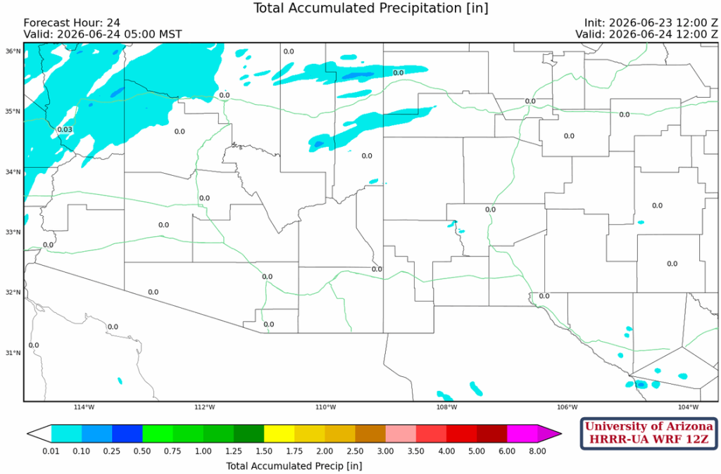
The total precipitation through Thursday evening is mainly in the mountains.

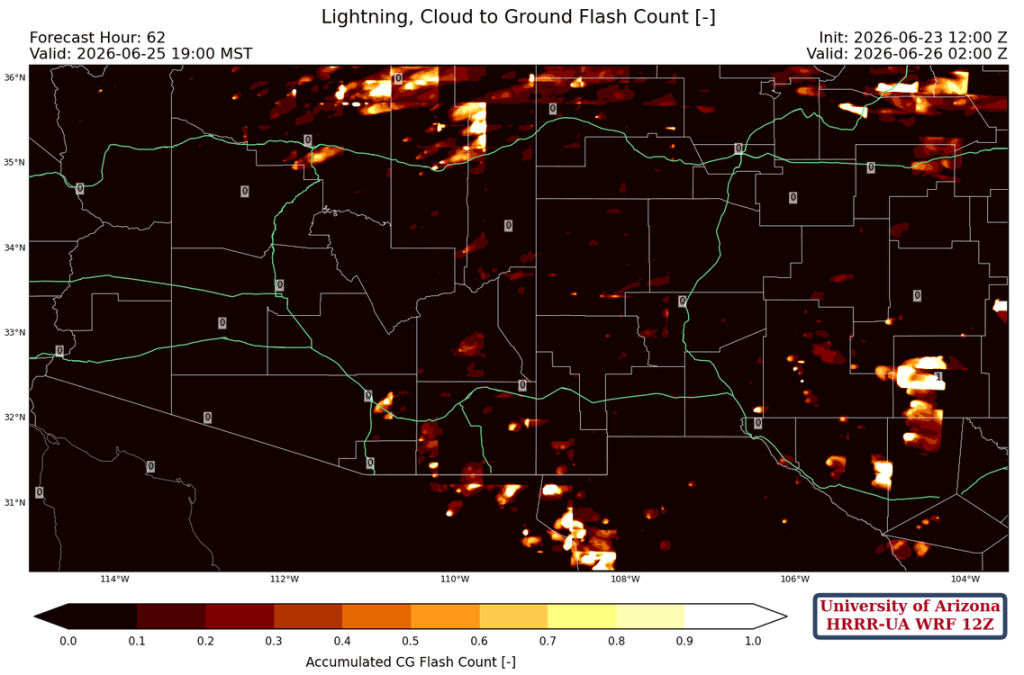
Not much rain, so the main risk over these 3 days is lightning starting fires in the mountains and not getting enough wetting rain to put them out. Below is the cumulative number of cloud-to-ground strikes predicted over the next few days. The scale doesn’t mean much in physical terms (it’s a normalized value, so more strikes mean a value closer to 1), but the location of the strikes is the key information here. Hot spots in the Chiricahuas and Rincon Mountains, so hopefully no fires are started there.
The longer-ranging global models are showing monsoon precipitation beginning in Tucson at the end of the month. The storms will initially be around the mountains, as the moisture is only borderline good enough with precipitable water at about 1 inch (25mm). Though, as shown by the spread of the ensemble members, the forecast that far out is highly uncertain.

Discussion written by Pat Holbrook and Patrick Bunn