

Summary
Low-level water vapor satellite imagery shows significant moisture moving into the Southwest from the tropical Pacific, resulting in cloud cover and precipitation across the region. In Arizona, precipitation and thunderstorms are linked to an upper-level low near San Diego.
Today, storms are likely to develop where surface heating is strong enough, aided by synoptic lift ahead of the low’s eastward movement. Forecasts indicate isolated strong storms with hail and heavy rain could form this evening, mainly in Yavapai County and the Mogollon Rim. Storms may develop in southern Pima and eastern Arizona. New Mexico is expected to see the heaviest rainfall.
By tomorrow, most of Arizona should see a lull in storm activity, while thunderstorms continue in New Mexico’s mountains. The remnants of Hurricane Polo are expected to bring another moisture push and rainfall, though given its current predicted track, most of it will be along and south of the international border in AZ/NM as the system weakens and moves eastward into Mexico.
Yesterday’s Weather
For the past two days, an upper-level low near San Diego has interacted with tropical moisture across Arizona and New Mexico. Yesterday, wind shear was low, with surface flow and winds aloft all from the same direction. Without shear, storms forming in the mountains could not move northward into the valleys, as cirrus anvils cut off surface heating.
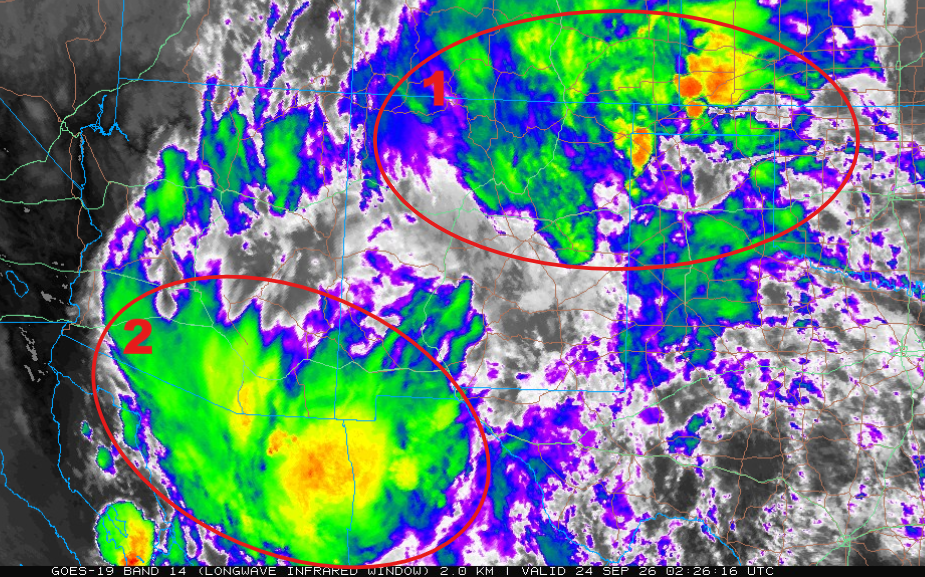
The infrared satellite image from 7:30 pm on Wednesday shows two thunderstorm areas. The first area, over the border of New Mexico, Colorado, and the Oklahoma panhandle, was remnants of Tuesday’s storms associated with the first shortwave trough rotating around the upper-level low. The second area shows storms in southern Arizona and northern Mexico from a second embedded shortwave trough. Once again, anvils from the storms blew north, cutting off surface heating in Arizona.
All forecast models have struggled with this system, as it is moving in from the Pacific Ocean, where there are few to no surface or upper-air observations.
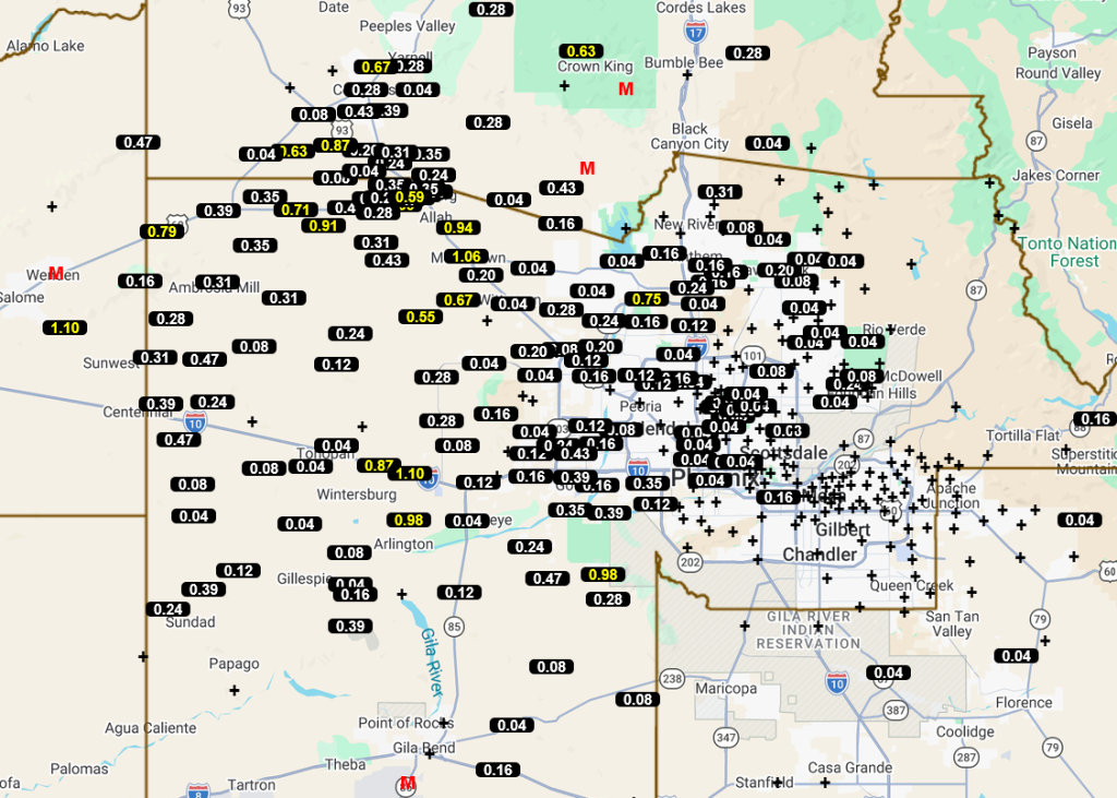
The rainfall totals through 7 am from the Maricopa County Alert System rain gauges are shown below; western and northern Maricopa County saw the heaviest precipitation.
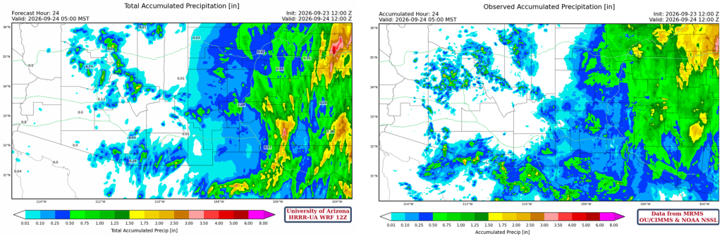
The HRRR-UA WRF 12Z 24-hour accumulated precipitation forecast (left) and corresponding observed precipitation from MRMS (right) show that the forecast captured the pattern in Arizona, though it missed the westerly extent of the two precipitation bands. The focus of activity is in New Mexico, and the forecast was better toward the northeastern corner of the state rather than the southeastern.
Analysis
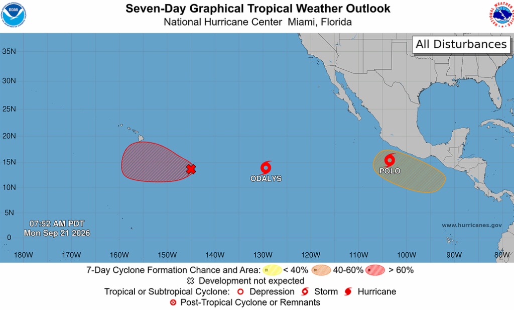
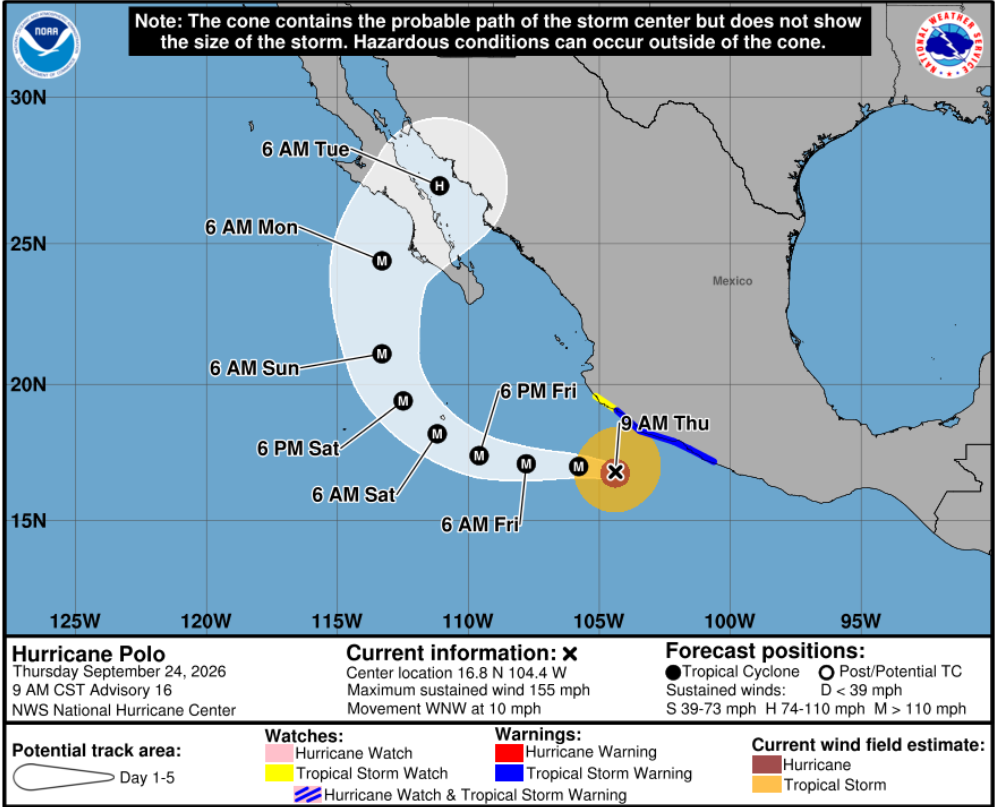
Hurricane Polo is much further south and is not currently interacting with the upper low. Polo underwent rapid intensification and has produced sustained winds of 180 mph. It may affect Arizona weather early next week, though it will be much weaker by then. Current forecasts show the center moving into the central Baja Peninsula on Tuesday.
The 6:30 am low-level water vapor satellite image shows moisture transport from the tropical Pacific between Hurricanes Polo and Odalys. An area of clouds and precipitation spans the Southwest region. Precipitation in western Arizona is linked to cold air aloft associated with the upper-level low near San Diego. With a moist atmosphere across the region, it won’t take much surface heating to initiate storms; cold air advecting from the low to the west will cause vertical ascent and thunderstorm development ahead of its path as it moves east.

Surface dew point temperatures are dry in northern Arizona and New Mexico, though there’s more surface moisture to the south of the dry air.

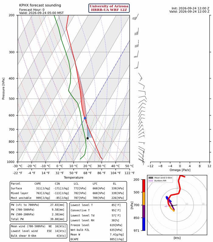
The observed sounding data from Phoenix was not available today. The 12Z HRRR-UA WRF initialization shows the showers and thunderstorms developing in an unstable layer above 640 mb.
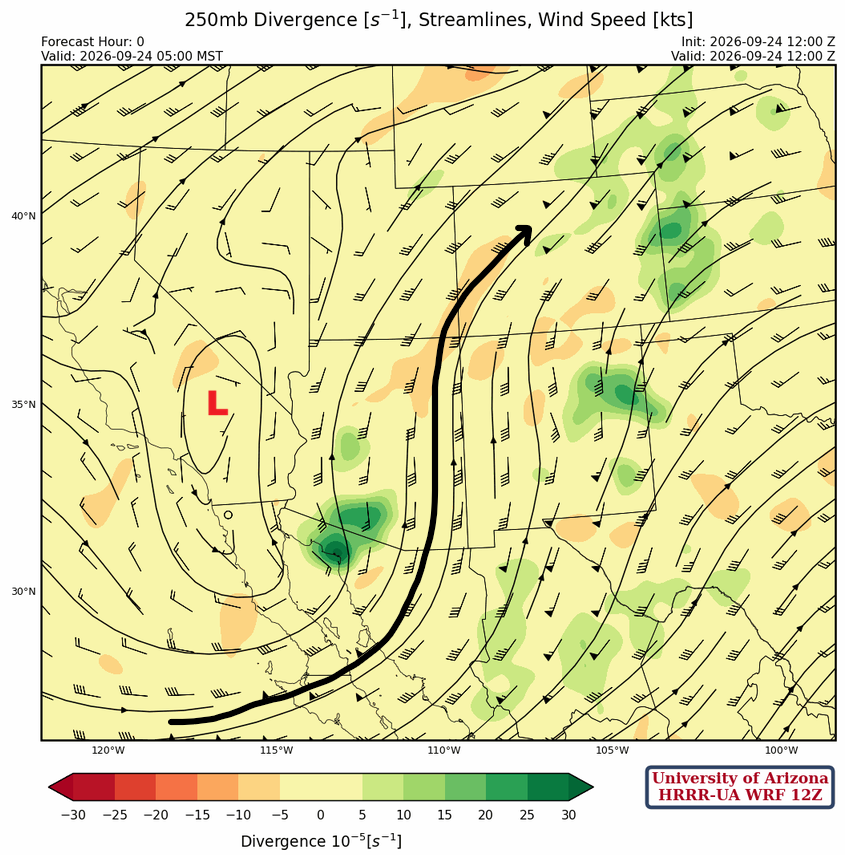
The upper low has moved northeast into south-central California, with the jet stream from central Baja into New Mexico and Colorado.
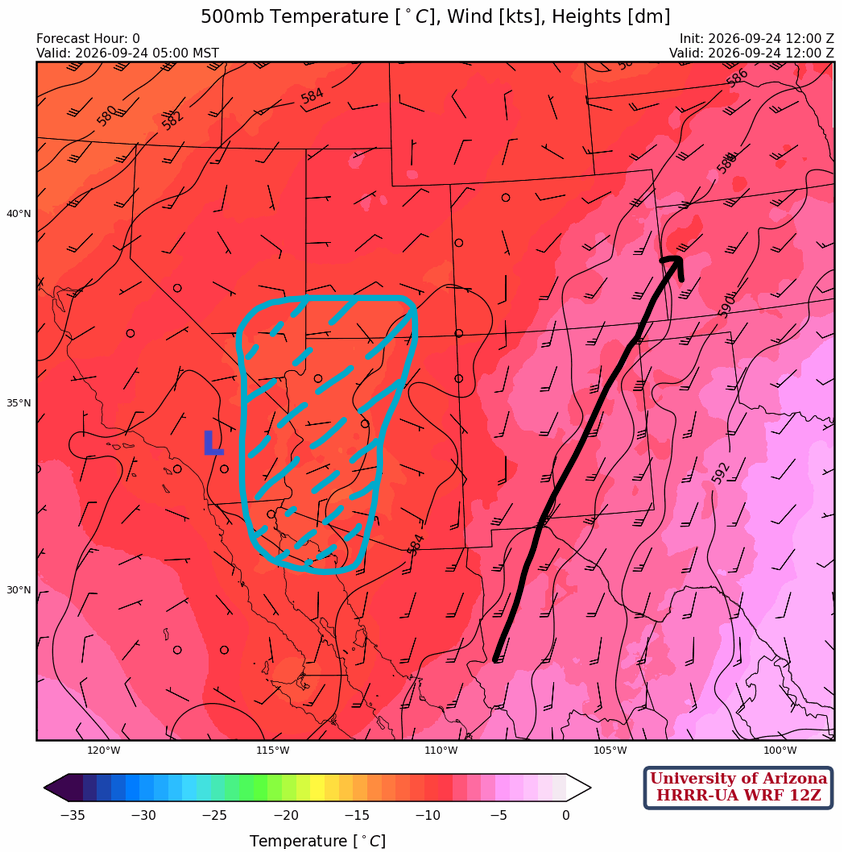
The upper low is over south-central California. The shaded area represents –10°C temperatures ahead of the upper low, a prime location for synoptic-scale vertical ascent that can develop thunderstorms.
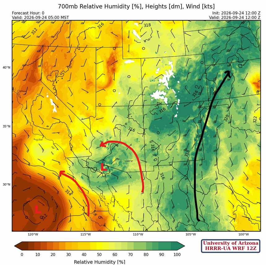
A low in the northern Gulf of California reflects the upper-level low in California. Another low is centered farther west in the Pacific Ocean. The monsoon flow has shifted eastward into eastern New Mexico. There remains moisture in southern Arizona but is cut off from the monsoon flow.
Today
This morning’s cloud cover and precipitation complicate this afternoon and evening’s forecast. Some areas will get enough surface heating for storms to develop, while others will not. The 12Z HRRR-UA WRF forecast Tucson forecast sounding for 5 pm shows potential for isolated strong storms. The soundings show good wind shear and enough precipitable water.

The forecast predicts storms forming in eastern Pima County this evening and moving northward into eastern Pinal County and western and central Graham County. Some storms may contain hail and locally heavy rain. Overnight, storms are forecast to develop in the Phoenix metro area under the coldest air aloft. Strong thunderstorms will continue moving across eastern New Mexico.
Total precipitation through midnight tonight shows heavier rain along the Mogollon Rim and Yavapai County, but most precipitation is in southern and eastern New Mexico.
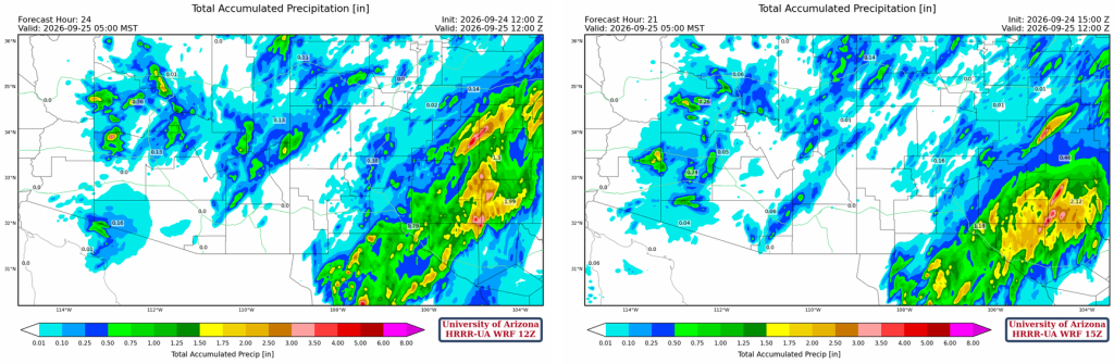
Tomorrow
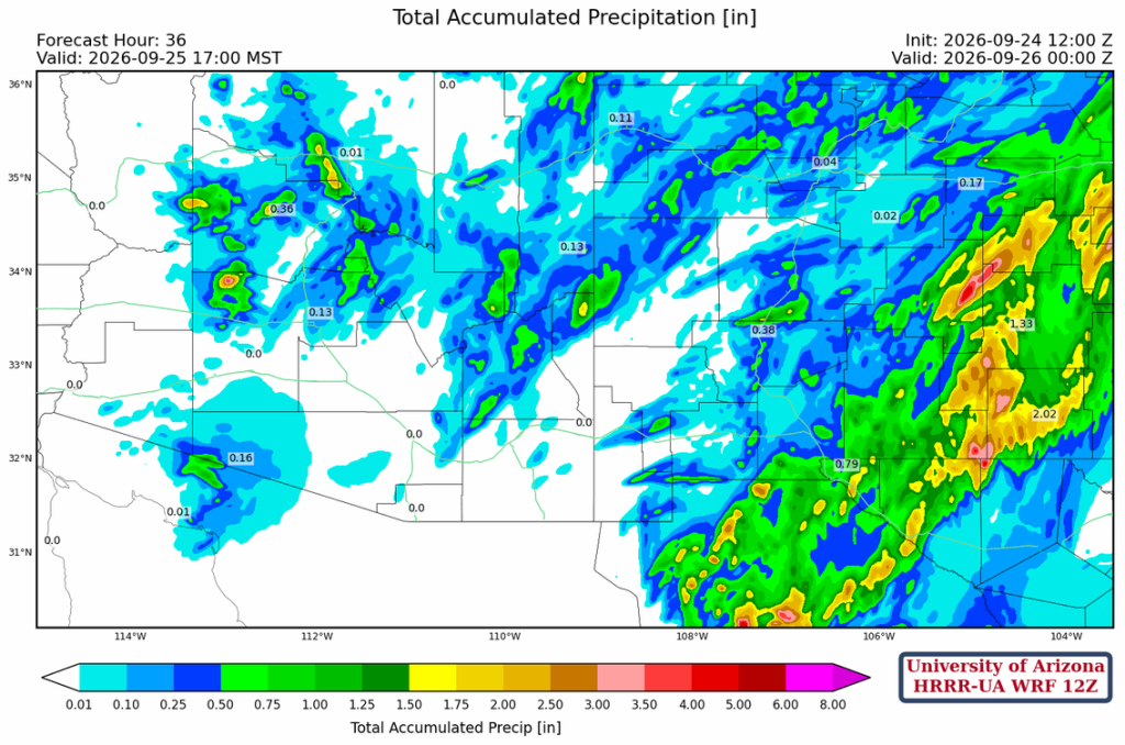
It should be a down day for most of Arizona, while thunderstorms in New Mexico will be in the mountains of central and southwest New Mexico.
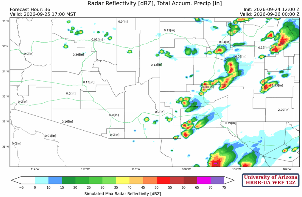
The total accumulated precipitation through 36 hours is shown below; northern Arizona and New Mexico are still where the majority of precipitation is expected.
Outlook
The National Hurricane Center’s forecast for Hurricane Polo is below. Polo will weaken as it crosses the central Baja Peninsula and is predicited to move eastward into Mexico. Given the current track, most precipitation associated with Polo will be along and south of the international border.
Discussion written by Pat Holbrook and Patrick Bunn